close
-
Layers w
- Weather Layers
- Pro
- Pro
- Pro
- Pro
- Pro
- Pro
- More Layers
- Pro
- Pro
- Pro
- Pro
-
Upgrade to

3D
Trail Conditions
- Unknown
- Snow Groomed
- Snow Packed
- Snow Covered
- Snow Cover Partial
- Freeze/thaw Cycle
- Icy
- Prevalent Mud
- Wet
- Variable
- Ideal
- Dry
- Very Dry
Trail Flow (Ridden Direction)
Trailforks scans users ridelogs to determine the most popular direction each trail is ridden. A good flowing trail network will have most trails flowing in a single direction according to their intension.
The colour categories are based on what percentage of riders are riding a trail in its intended direction.
The colour categories are based on what percentage of riders are riding a trail in its intended direction.
- > 96%
- > 90%
- > 80%
- > 70%
- > 50%
- < 50%
- bi-directional trail
- no data
Trail Last Ridden
Trailforks scans ridelogs to determine the last time a trail was ridden.
- < 2 days
- < 1 week
- < 2 weeks
- < 1 month
- < 6 months
- > 6 months
Trail Ridden Direction
The intended direction a trail should be ridden.
- Downhill Only
- Downhill Primary
- Both Directions
- Uphill Primary
- Uphill Only
- One Direction
Contribute Details
Colors indicate trail is missing specified detail.
- Description
- Photos
- Description & Photos
- Videos
Trail Popularity ?
Trailforks scans ridelogs to determine which trails are ridden the most in the last 9 months.
Trails are compared with nearby trails in the same city region with a possible 25 colour shades.
Think of this as a heatmap, more rides = more kinetic energy = warmer colors.
- most popular
- popular
- less popular
- not popular
ATV/ORV/OHV Filter
Max Vehicle Width
inches
US Cell Coverage
Legend

Radar Time
Activity Recordings
Trailforks uses anonymized public activity data.
?
Activity Recordings
Trailforks uses anonymized public activity data.
?
Personal Heatmap
▶
Activity Types
all
/
none
▶
Options
2
Date range
month
–
Winter Trails
Warning
A routing network for winter maps does not exist. Selecting trails using the winter trails layer has been disabled.
Missing Trails
Most Popular
Least Popular
Trails are colored based on popularity. The more popular a trail is, the more red. Less popular trails trend towards green.
Jump Magnitude Heatmap
Heatmap of where riders jump on trails. Zoom in to see individual jumps, click circles to view jump details.
BC Backroad Status
![map legend]()
Service Road Atlas is a free to use, community-driven service for viewing and creating reports on the numerous back-country service roads around B.C. and Alberta.

Slope Aspect
Direction the slope faces
Trails Deemphasized
Trails are shown in grey.
Only show trails with no bike usage.
Suggested Layers
Based on selected activity type
Save the current map location and zoom level as your default home location whenever this page is loaded.
Save
No description for Queens has been added yet!
Login or register to submit one.
Activities Click to view
- Mountain Bike
28 trails
- Gravel Bike
0 trails
- Adaptive Bike
0 trails
- Winter Fat Bike
0 trails
- Hike
26 trails
- Trail Running
26 trails
Region Details
- 7
- 7
- 8
- 6
Region Status
Open as of Jun 18, 2026Stats
- Avg Trail Rating
- Trails (view details)
- 28
- Trails Mountain Bike
- 28
- Trails Hike
- 26
- Trails Trail Running
- 26
- Total Distance
- 16 miles
- Total Descent Distance
- 5 miles
- Total Descent
- 501 ft
- Total Vertical
- 190 ft
- Highest Trailhead
- 191 ft
- Reports
- 806
- Photos
- 474
- Ridden Counter
- 10,655
Sub Regions
-
Cunningham Park
- 6
- 8
- 6
-
Forest Park
- 1
-
Kissena Park
Popular Queens Mountain Biking Trails
• 90 ★ 3.7 • 2,054 ft • 23 ft • 753 • • mtb
is a trail that helped build to train our volunteers on sustainable trail design. This trail starts off with a chicane to a log riding feature then surfs it's way along the contours then climbs back up and past a few more log features...
• 80 ★ 4.2 • 4,908 ft • 17 ft • 732 • • mtb
starts with a few ramps to launch or roll then twists it's way through the jungle of greenery constantly going up and down a few tiny hills which brings you to the play station where there are three different sized jumps to practice on...
• 100 ★ 3.5 • 4,199 ft • 29 ft • 731 • • mtb
was named after a that was found in the woods at this location. This trail has a little bit of everything, log overs, berms, launches, rock gardens and swoopy xc sections.
• 75 ★ 3.1 • 1 mile • 56 ft • 707 • • mtb
This trail was predominately built with the help from the Corps and is one of the longest trails in the park. It's the most difficult blue square trail bordering on black diamond for a few technical trail features, a small half pipe...
• 95 ★ 4.0 • 1,086 ft • 5 ft • 666 • • mtb
winds it's way through a gnarly boulder field, some can be rolled over. Twist your way through but watch out for the ankle biting boulders.
• 100 ★ 4.5 • 771 ft • 0 ft • 634 • • mtb
This often missed loop is a short but sweet trail that keeps you busy as you fly up and down the hills until it spits you right back out where you started.
Queens Mountain Bike Routes
Cunningham Blue Featured
★ 5.0 • 5 miles • 173 ft • 10 • Loop •
This route included BLUE trails at Cunningham Park.
Cunningham Complete Featured
★ 5.0 • 8 miles • 280 ft • 16 • Loop •
This route included ALL trails at Cunningham Park.
• 13 miles • 474 ft • 28 •
• 17 miles • 683 ft • 26 •
• 14 miles • 501 ft • 25 •
• 11 miles • 427 ft • 27 •
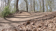
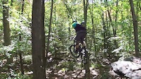
Photos of Queens Mountain Bike


Current Trail Warnings
| status | trail | date | condition | user | info |
|---|---|---|---|---|---|
| Viper East | May 29, 2026 @ 8:27am (America/New_York) May 29, 2026 | Ideal | krka73 | Tree down... | |
| Ringer | May 29, 2026 @ 8:28am (America/New_York) May 29, 2026 | Ideal | krka73 | Tree down... |
Recent Trail Reports
| status | trail | date | condition | info | user |
|---|---|---|---|---|---|
| Poison Rock | Jun 18, 2026 @ 6:32pm (America/New_York) Jun 18, 2026 | Ideal | Apestesi87 CLIMB-CU | ||
| Teepee | May 30, 2026 @ 4:20pm (America/New_York) May 30, 2026 | Unknown | sick4surf CLIMB | ||
| West Loop | May 30, 2026 @ 4:20pm (America/New_York) May 30, 2026 | Unknown | sick4surf CLIMB | ||
| Iguana | May 29, 2026 @ 8:29am (America/New_York) May 29, 2026 | Ideal | krka73 | ||
| Green Apple | May 8, 2026 @ 3:36pm (America/New_York) May 8, 2026 | Unknown | Figman5000 | ||
| Thrilla | May 1, 2026 @ 4:03pm (America/New_York) May 1, 2026 | Unknown | sick4surf CLIMB | ||
| East Loop | Mar 14, 2026 @ 2:03pm (America/New_York) Mar 14, 2026 | Unknown | sick4surf CLIMB | ||
| Boomerang | Nov 20, 2025 @ 1:13pm (America/New_York) Nov 20, 2025 | Ideal | Chetdoo | ||
| IMBA | Nov 20, 2025 @ 1:13pm (America/New_York) Nov 20, 2025 | Freeze/thaw Cycle | Chetdoo | ||
| Old Skool | Nov 20, 2025 @ 1:13pm (America/New_York) Nov 20, 2025 | Ideal | Chetdoo |
Activity Feed
| username | action | type | title | date |
|---|---|---|---|---|
| valo_cas | wishlist | region | activity #97388211 | Jun 20, 2026 @ 6:28am Jun 20, 2026 |
| valo_cas | ridden | route | activity #97387436 | Jun 20, 2026 @ 6:15am Jun 20, 2026 |
| Apestesi87 | add | report | activity #97279420 | Jun 18, 2026 @ 3:32pm Jun 18, 2026 |
| sick4surf | add | report | activity #95882251 and 1 more | May 30, 2026 @ 1:20pm May 30, 2026 |
| krka73 | add | report | activity #95769450 and 3 more | May 29, 2026 @ 5:23am May 29, 2026 |
Recent Comments
| username | type | title | comment | date |
|---|---|---|---|---|
| report | Thanks! The picture helps. We’ll send... | May 8, 2026 @ 3:13pm May 8, 2026 | ||
| report | Thank you! | Dec 23, 2025 @ 1:03pm Dec 23, 2025 | ||
| report | 😂😂 | Nov 22, 2025 @ 8:51pm Nov 22, 2025 | ||
| report | Thank you for reporting! | Nov 21, 2025 @ 6:17am Nov 21, 2025 | ||
| report | Thank you for reporting with great details! | Oct 15, 2025 @ 4:50pm Oct 15, 2025 |
Local Badges
-

Epic Ride Climb 2k1 awarded -

Climbing 10k Badge14 awarded -

Climbing 100k Badge0 awarded -

Epic Ride Descent 2k1 awarded -

Descent 10k Badge14 awarded -

Descent 100k Badge0 awarded
Activity Type Stats
| activitytype | trails | distance | descent | descent distance | total vertical | rating | global rank | state rank | photos | reports | routes | ridelogs |
|---|---|---|---|---|---|---|---|---|---|---|---|---|
| Mountain Bike | 28 | 16 miles | 502 ft | 5 miles | 190 ft | #1,741 | #643 | 471 | 806 | 2 | 12,054 | |
| Hike | 26 | 15 miles | 479 ft | 5 miles | 190 ft | #8,904 | #3,122 | 5 | 799 | 158 | ||
| Trail Running | 26 | 15 miles | 479 ft | 5 miles | 190 ft | #8,499 | #2,829 | 799 | 103 |
Frequently Asked Questions About Queens
▼
What are the best places to ride in Queens?
Queens has 3 areas to explore for mountain biking. The top rated areas are:
▼
What are the highest rated mountain biking trails in Queens?
The highest rated mountain biking trails in Queens are:
- Thrilla (4.1/5)
- Poison Rock (4.1/5)
- Boomerang (4.1/5)
- Mustang Loop (4/5)
- East Loop (3.9/5)
▼
What is the best time of the year to ride in Queens?
Based on ride log data, the most popular months to ride in Queens are:
- July (263 activities)
- September (250 activities)
- August (219 activities)
▼
Where can I park to ride in Queens?
There are 1 parking locations listed in Queens. The most popular parking spots are:
Trails
Points of Interest
- By brenthillier
 NSMBA TRAILFORKS & contributors
 - Admins: CLIMB
- #9216 - 4,415 views
- queens activity log | embed map of Queens mountain bike trails | queens mountain biking points of interest
Downloading of trail gps tracks in kml & gpx formats is enabled for Queens.
You must login to download files.