close
-
Layers w
- Weather Layers
- Pro
- Pro
- Pro
- Pro
- Pro
- Pro
- More Layers
- Pro
- Pro
- Pro
- Pro
-
Upgrade to

3D
Trail Conditions
- Unknown
- Snow Groomed
- Snow Packed
- Snow Covered
- Snow Cover Partial
- Freeze/thaw Cycle
- Icy
- Prevalent Mud
- Wet
- Variable
- Ideal
- Dry
- Very Dry
Trail Flow (Ridden Direction)
Trailforks scans users ridelogs to determine the most popular direction each trail is ridden. A good flowing trail network will have most trails flowing in a single direction according to their intension.
The colour categories are based on what percentage of riders are riding a trail in its intended direction.
The colour categories are based on what percentage of riders are riding a trail in its intended direction.
- > 96%
- > 90%
- > 80%
- > 70%
- > 50%
- < 50%
- bi-directional trail
- no data
Trail Last Ridden
Trailforks scans ridelogs to determine the last time a trail was ridden.
- < 2 days
- < 1 week
- < 2 weeks
- < 1 month
- < 6 months
- > 6 months
Trail Ridden Direction
The intended direction a trail should be ridden.
- Downhill Only
- Downhill Primary
- Both Directions
- Uphill Primary
- Uphill Only
- One Direction
Contribute Details
Colors indicate trail is missing specified detail.
- Description
- Photos
- Description & Photos
- Videos
Trail Popularity ?
Trailforks scans ridelogs to determine which trails are ridden the most in the last 9 months.
Trails are compared with nearby trails in the same city region with a possible 25 colour shades.
Think of this as a heatmap, more rides = more kinetic energy = warmer colors.
- most popular
- popular
- less popular
- not popular
ATV/ORV/OHV Filter
Max Vehicle Width
inches
US Cell Coverage
Legend

Radar Time
Activity Recordings
Trailforks uses anonymized public activity data.
?
Activity Recordings
Trailforks uses anonymized public activity data.
?
Personal Heatmap
▶
Activity Types
all
/
none
▶
Options
2
Date range
month
–
Winter Trails
Warning
A routing network for winter maps does not exist. Selecting trails using the winter trails layer has been disabled.
Missing Trails
Most Popular
Least Popular
Trails are colored based on popularity. The more popular a trail is, the more red. Less popular trails trend towards green.
Jump Magnitude Heatmap
Heatmap of where riders jump on trails. Zoom in to see individual jumps, click circles to view jump details.
BC Backroad Status
![map legend]()
Service Road Atlas is a free to use, community-driven service for viewing and creating reports on the numerous back-country service roads around B.C. and Alberta.

Slope Aspect
Direction the slope faces
Trails Deemphasized
Trails are shown in grey.
Only show trails with no bike usage.
Suggested Layers
Based on selected activity type
Save the current map location and zoom level as your default home location whenever this page is loaded.
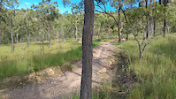
SaveThe mountains of Far North Queensland were on the UCI World Cup circuit in the 90s. Those walking tracks that were ridden by MTB pioneers are still ridden and the region has not had the explosion of machine groomed development like the rest of the country. Boomerang Bike Park in the Gold Coast Hinterland is at the other end of the scale with enormous jump lines and shuttles.
Stats
- Avg Trail Rating
- Trails (view details)
- 3,633
- Trails Mountain Bike
- 3,019
- Trails E-Bike
- 2,693
- Trails Gravel Bike
- 384
- Trails Adaptive Bike
- 528
- Trails Winter Fat Bike
- 159
- Trails Horse
- 276
- Trails Hike
- 2,794
- Trails Trail Running
- 2,784
- Trails Dirtbike/Moto
- 70
- Trails Observed Trials
- 1
- Trails ATV/ORV/OHV
- 53
- Total Distance
- 4,393 miles
- Total Descent
- 581,988 ft
- Total Vertical
- 5,260 ft
- Highest Trailhead
- 5,261 ft
- Reports
- 34,450
- Photos
- 8,008
- Ridden Counter
- 850,910
Articles
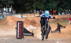
Photo Report: Crankworx Cairns Dual Slalom 2025
May 27, 2025 from pinkbike.com
The final event of Crankworx Cairns wrapped up an epic week in the jungle.
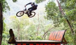
Photo Epic: Crankworx Cairns Slopestyle 2025
May 26, 2025 from pinkbike.com
Super Sunday delivered in the jungle of Cairns.

Results: Slopestyle - Crankworx Cairns 2025
May 24, 2025 from pinkbike.com
The results are in from the Crankworx Cairns Slopestyle.
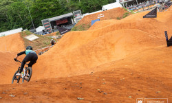
Photo Report: Crankworx Cairns Full Tilt 2025
May 24, 2025 from pinkbike.com
Crankworx Cairns saw the refreshing debut of the brand-new Full Tilt format, and the crowds showed up in full force to witness the chaos unfold.
Popular Trail Networks
view all areas »Sub Regions
- Central Queensland Region (159)
- Agnes Water (15)
- Bluff (1)
- Charters Towers (1)
- Emerald (5)
- Gladstone (71)
- Rockhampton (65)
- Expedition National Park (0)
- Agnes Water (15)
- Darling Downs and South West Queensland Region (12)
- Far North Queensland Region (221)
- Atherton (34)
- Cairns (116)
- Bel-air Trails (5)
- Copperlode Dam (9)
- Kuranda Downhill (3)
- Marino's Hill (3)
- Misty Mountains Trail Network (13)
- Palmer's Bike Park (5)
- Smithfield (55)
- Southside Edmonton Trails (10)
- Cardwell (10)
- Croydon (19)
- Port Douglas (18)
- Weipa (22)
- Horn Island (21)
- Weipa Region (1)
- Wujal Wujal (2)
- Yungaburra (0)
- Mackay, Isaac & Whitsunday Region (104)
- Airlie Beach (24)
- Hamilton Island (13)
- South Molle Island (5)
- Ball Bay (4)
- Finch Hatton (36)
- Mackay (48)
- Rowallan Park (42)
- Netherdale (1)
- Eungella (1)
- Airlie Beach (24)
- Moreton Bay (4)
- Redcliffe (2)
- Redcliffe (2)
- North Queensland Region (102)
- Ingham (29)
- Abergowrie (29)
- Mount Surprise (2)
- Townsville (152)
- Trebonne (0)
- Clump Mountain National Park (0)
- Lannercost State Forest (0)
- Porcupine Gorge National Park (0)
- Ingham (29)
- North Stradbroke Island (1)
- North West Queensland Region (39)
- South East Queensland Region (197)
- Kooralbyn (26)
- Springbrook (8)
- Toogoolawah (4)
- Toowoomba (148)
- Jubilee Park (55)
- Mount Peel (41)
- Mountain Bike Mecca (7)
- Neilson Park (4)
- Picnic Point Parklands (10)
- Redwood Park (6)
- NV Gravity Bike Park (11)
- Sunshine Coast Region (354)
- Ballandean (5)
- Beaudesert (40)
- Blackwater (25)
- Brisbane (678)
- Banks Street Reserve (2)
- Belmont Hills Reserve (6)
- Bunyaville Conservation Park (47)
- Chelsea Road Reserve (9)
- Cicada Park (1)
- Clear Mountain Conservation Park (8)
- Cornubia Forest Park (23)
- Daisy Hill (70)
- D’Aguilar National Park (147)
- Eildon Hill Reserve / Constitution (1)
- Enoggera Reservoir (14)
- Fort Bushland Reserve (1)
- Gap Creek Reserve (44)
- Glasshouse Mountains Conservation Park (30)
- Grange Forest Park (4)
- House Mountain (6)
- John Oxley Reserve (0)
- Karawatha Forest (19)
- Keperra Brushland (2)
- Moggill Regional Park (12)
- Mount Coot-tha Forest (52)
- Mount Gravatt (21)
- Mount Ommaney Bushland Reserve (1)
- Pooh Corner Bushland Reserve (4)
- Pullen Reach Bushland Reserve (1)
- Raven Street Reserve (6)
- Rocks Riverside Park (6)
- Samford Conservation Park (37)
- Sergeant Dan Stiller Memorial Reserve (1)
- Toohey Forest (73)
- Tyler Reserve (6)
- Venman Bushland National Park (15)
- Whites Hill Reserve (1)
- Wolston Creek Bushland Reserve (8)
- Wyaribah (2)
- Bunya Mountains (0)
- Burpengary East (10)
- Clermont (1)
- Conondale (5)
- Flaxton (0)
- Gatton (1)
- Adare Homestead (0)
- Gold Coast (170)
- Bonogin (8)
- Boomerang Farm Bike Park (24)
- Coombabah Lakelands Conservation Area (12)
- Glossy Black Reserve (15)
- Hinze Dam (9)
- Illinbah (1)
- Lamington National Park (5)
- Nerang National Park (81)
- Old Tambo (6)
- Gold Coast (150)
- Ipswich (238)
- Kuranda (4)
- Logan (97)
- Bahrs Scrub (5)
- Spring Mountain (86)
- Underwood Park (11)
- Logan City (39)
- Mapleton (2)
- Mareeba (15)
- Moogerah (0)
- Moreton Island (1)
- Mount Kelly (5)
- North Tamborine (0)
- Paluma (12)
- Paluma Dam (11)
- Proserpine (7)
- Rathdowney (0)
- Redland Bay (6)
- Redland City (181)
- Upper Caboolture (0)
- Warwick (2)
- Whitsunday Region (2)
- Shute Harbor (2)
- Shute Harbor (2)
- Wide Bay Burnet Region (273)
- Amamoor (1)
- Bundaberg (54)
- Promisedland Road (52)
- Gympie (43)
- Hervey Bay (62)
- K'gari (5)
- Kingaroy (13)
- Kybong (22)
- Maryborough (48)
- Mundubbera (0)
- Nanango (3)
- Wondai (22)
- McEuen State Forest (17)
- Cooloola (0)
- Beerburrum (20)
- Boreen Point (4)
- Buderim (1)
- Caloundra (22)
- Cootharaba (6)
- Eumundi (4)
- Kenilworth (26)
- Kobble Creek (3)
- Maleny (1)
- Mooloolah (59)
- Boneyards (39)
- Dularcha National Park (12)
- Ewen Maddock Dam (8)
- Mountain Creek (1)
- Nambour (72)
- Parklands (69)
- Noosa Heads (32)
- Noosa National Park (13)
- Noosa Trail Network (17)
- Noosa Shire (3)
- Tewantin (95)
- Woondum (4)
- Weyba (0)
Popular Queensland Mountain Biking Trails
• 100 ★ 3.5 • 2 miles • 196 ft • 3,990 •
An essential part of the valley trail network. This track was an alternative to the old track. It's now a favorite way in and out for many riders.
• 100 ★ 4.0 • 4,285 ft • 13 ft • 3,233 •
One of Daisy Hill's most popular trails. Flowy, one-direction singletrack with plenty of berms and pump sections across its 1.4km.
• 100 ★ 4.0 • 3,481 ft • 18 ft • 3,193 •
The trail flows nicely from /Tunnel of Love and is an easy trail with only one slightly rocky gentle descent. A popular trail at Daisy Hill as it helps connect riders from to and beyond. A couple of nice berms will allow beginners to...
• 100 ★ 4.4 • 2,260 ft • 12 ft • 3,151 •
Great flow track with a lot of fun features including a rock garden to start with and a couple of gap jumps which can be pumped as well. Used to be named "Tunnel of Love".
• 100 ★ 3.7 • 3,983 ft • 71 ft • 2,984 •
A great flow track that goes from the 5 ways & has a few berms near the top of the trail. It opens out into a faster run towards the last third. It ends on the fire trail which you can follow back around to the five ways (which actually...
• 100 ★ 3.2 • 1,765 ft • 6 ft • 2,784 •
Easy connection trail that has a minor creek crossing midway. When exiting the trail at the trail end, there's a small but difficult climb over a number of tree roots that sit proud. is named after Gillian Duncan, the author of "Where...
Queensland Mountain Bike Routes
Castle Hill Mega Loop Featured
★ 5.0 • 13 miles • 1,948 ft • 143 • Loop •
Every singletrack on the hill linked up into one mega ride.
Rookie Route Featured
★ 1.0 • 3 miles • 252 ft • 3 • Loop •
This route takes in the new access trail (Rookie Road) and beginners loop (Yet as of writing). Both trails...
MAD: Rowallan's Easy Flow Featured
3 miles • 360 ft • 14 • Out & Back •
Haven't got much time?? or Want an easy introduction to Rowallan Park MTB?? This is the route for you. Get...
Winter Solstice Ride - Super Easy Featured
5 miles • 810 ft • 7 • Loop •
The super easy version of the Winter Solstice Night Ride, taking in , into & before upping back into...
MAD: short 102 to 101 Featured
1 mile • 114 ft • 2 • Loop •
From Carpark across and down into 102 with a shortcut across to 101 and down back to the Carpark
Winter Solstice Ride - Moderate Featured
6 miles • 1,081 ft • 20 • Loop •
The moderate version of the Winter Solstice Night Ride, taking in the succulent blue airflow trails. Start...
Photos of Queensland Mountain Bike
Videos of Queensland Mountain Bike
trail: Oh What A Feeling
0:18 |
15 |
Mar 17, 2026
0:09 |
7 |
Feb 26, 2026
trail: Container Drop
0:13 |
6 |
Feb 23, 2026
trail: R and B
0:20 |
10 |
Feb 23, 2026
trail: Container Drop
0:14 |
7 |
Feb 23, 2026
trail: Green With NV
0:39 |
11 |
Feb 23, 2026
trail: Gillian's
0:07 |
35 |
Jul 9, 2025
trail: Gillian's
0:12 |
|
Jun 15, 2025
Current Trail Warnings
| status | trail | date | condition | user | info |
|---|---|---|---|---|---|
| Skyfall Hidden Vale Adventure Park | Jun 20, 2026 @ 7:46am (Australia/Brisbane) 2 days | Ideal | JamesM1302 | E-Bike Messy, needs a clean up. | |
| Wombats Connection Nerang National Park | Jun 20, 2026 @ 5:56am (Australia/Brisbane) 2 days | Variable | sutto47 | ||
| Beginner Jump Line Smithfield | Jun 16, 2026 @ 3:37pm (Australia/Brisbane) Jun 15, 2026 | Variable | MeLLeR |
Recent Trail Reports
| status | trail | date | condition | info | user |
|---|---|---|---|---|---|
| Mad Max 3 Brisbane | Jun 21, 2026 @ 12:05pm (Australia/Brisbane) 21 hours | Ideal | tomaley68 | ||
| Bees Knees Daisy Hill | Jun 21, 2026 @ 12:05pm (Australia/Brisbane) 21 hours | Ideal | tomaley68 | ||
| Bronzewing Daisy Hill | Jun 21, 2026 @ 12:05pm (Australia/Brisbane) 21 hours | Variable | tomaley68 | ||
| Jim's Track Daisy Hill | Jun 21, 2026 @ 12:05pm (Australia/Brisbane) 21 hours | Ideal | tomaley68 | ||
| Lace Monitor Daisy Hill | Jun 21, 2026 @ 12:05pm (Australia/Brisbane) 21 hours | Variable | tomaley68 | ||
| Jim Finch Daisy Hill | Jun 21, 2026 @ 12:05pm (Australia/Brisbane) 21 hours | Ideal | tomaley68 | ||
| Flying Cloud Daisy Hill | Jun 21, 2026 @ 12:05pm (Australia/Brisbane) 21 hours | Ideal | tomaley68 | ||
| Glossy Black Extension Daisy Hill | Jun 21, 2026 @ 12:05pm (Australia/Brisbane) 21 hours | Ideal | tomaley68 | ||
| Grass Tree Link Daisy Hill | Jun 21, 2026 @ 12:05pm (Australia/Brisbane) 21 hours | Ideal | tomaley68 | ||
| Koala Daisy Hill | Jun 21, 2026 @ 12:05pm (Australia/Brisbane) 21 hours | Ideal | tomaley68 |
Activity Feed
| username | action | type | title | date |
|---|---|---|---|---|
| tomaley68 | add | report | activity #97469980 | Jun 21, 2026 @ 4:03am 12 hours |
| tomaley68 | add | report | activity #97469974 and 10 more | Jun 21, 2026 @ 4:03am 12 hours |
| PeteBarb | wishlist | region | activity #97460894 | Jun 21, 2026 @ 1:11am 15 hours |
| MartinNewby | wishlist | region | activity #97458243 | Jun 21, 2026 @ 12:00am 16 hours |
| Fridgefish | wishlist | region | activity #97456497 | Jun 20, 2026 @ 10:53pm 17 hours |
Recent Comments
| username | type | title | comment | date |
|---|---|---|---|---|
| trail | Tree across track on grass tree link hard to... | Jun 19, 2026 @ 5:58pm 2 days | ||
| trail | Awesome trail! Has some fast sections, some... | Jun 15, 2026 @ 5:18pm Jun 15, 2026 | ||
| trail | Cool trail, especially if you like steep blown... | Jun 15, 2026 @ 5:10pm Jun 15, 2026 | ||
| trail | Really enjoyed Route 65, didn’t fully... | Jun 14, 2026 @ 1:52am Jun 14, 2026 | ||
| trail | Sick but so many hills haha. Worth a trip if... | Jun 6, 2026 @ 10:54pm Jun 6, 2026 |
Local Badges
-

10 Green Trails155 awarded -

Top 10 Trails0 awarded -

10 Blue Trails155 awarded -
10 Blue Trails237 awarded -

Epic Ride Climb 2k48 awarded -
Epic Ride Climb 2k246 awarded
Bike & Skill Parks
| name | type | city | rating |
|---|---|---|---|
| Hidden Vale Adventure Park | bike park | Ipswich | |
| Tamrookum Creek Mountain Bike Park | bike park | Beaudesert | |
| Garapine | bike park | Kybong | |
| NV Gravity Bike Park | bike park | Gold Coast | |
| Samford Conservation Park Skills Park (Ironbark Gully) | skill park | Brisbane |
Upcoming Local Events
-
-
-
Local Trail Supporters
![]()
![Hit Bikes]()
![Trail Queens]()
![Tenmen Electrical]()
![On The Edge Events]()
![Bike On]()
- Logan City Trail Alliance
![Too Easy Transfers]()
![]()
- Dirty Possum
- D.I.R.T Club
![First National Caloundra]()
![]()
- DH Crew
- Zack Weight HVAP
![Oz Bearings & Industrial]()
- Townsville City Council
![Trek Kawana]()
![Epic Events Management]()
Activity Type Stats
| activitytype | trails | distance | descent | descent distance | total vertical | rating | global rank | state rank | photos | reports | routes | ridelogs |
|---|---|---|---|---|---|---|---|---|---|---|---|---|
| Mountain Bike | 3,018 | 3,595 miles | 444,682 ft | 1,570 miles | 4,072 ft | 7,620 | 34,345 | 522 | 1,187,465 | |||
| E-Bike | 2,693 | 3,212 miles | 402,949 ft | 1,397 miles | 4,072 ft | 149 | 31,214 | 190 | 108,284 | |||
| Gravel Bike | 384 | 571 miles | 62,664 ft | 243 miles | 3,691 ft | 4 | 3,476 | 41 | 2,524 | |||
| Adaptive Bike | 528 | 853 miles | 80,020 ft | 379 miles | 3,691 ft | 1 | 4,027 | 5 | 36 | |||
| Winter Fat Bike | 159 | 181 miles | 18,258 ft | 77 miles | 3,524 ft | 2,341 | 8 | |||||
| Horse | 276 | 495 miles | 51,362 ft | 214 miles | 4,062 ft | 4 | 8,343 | 2 | 252 | |||
| Hike | 2,794 | 3,696 miles | 457,789 ft | 1,581 miles | 5,259 ft | 159 | 30,360 | 41 | 39,895 | |||
| Trail Running | 2,784 | 3,705 miles | 456,755 ft | 1,584 miles | 5,259 ft | 27 | 30,366 | 84 | 45,222 | |||
| Dirtbike/Moto | 70 | 198 miles | 20,692 ft | 94 miles | 3,688 ft | 5 | 7,695 | 2 | 1,005 | |||
| Observed Trials | 1 | 1 mile | 112 ft | 2,736 ft | 112 ft | 1 | 41 | 95 | ||||
| ATV/ORV/OHV | 53 | 131 miles | 16,588 ft | 60 miles | 3,235 ft | 7,686 | 305 |
Activities
- Queensland Mountain Biking Trails
- Queensland E-Biking Trails
- Queensland Gravel Biking Trails
- Queensland Adaptive Biking Trails
- Queensland Winter Fat Biking Trails
- Queensland Horseback Trails
- Queensland Hiking Trails
- Queensland Trail Running Trails
- Queensland Dirtbiking Trails
- Queensland ATVing/Offroading Trails
Trails
Points of Interest
- Warrigal view of Lake Ross Viewpoint
- DCK Shelter (Private Property) Camping
- Rock garden TTF
- Ironbark trail hub Viewpoint
- Power pole bridge TTF
- Bridge TTF
- Meat grinder TTF
- Steep rock face TTF
- Rock Face TTF
- Rock n Roll 2 Fly Over Bridge TTF
- Puncak Jaya (4,820 m)
- Carstensz Timur (4,798 m)
- Sumantri (4,745 m)
- By brenthillier
 NSMBA TRAILFORKS & contributors
 - Admins: Jake-Hannah, Addzz
- #3454 - 66,930 views
- queensland activity log | embed map of Queensland mountain bike trails | queensland mountain biking points of interest polygons
Downloading of trail gps tracks in kml & gpx formats is enabled for Queensland.
You must login to download files.