close
-
Layers w
- Weather Layers
- Pro
- Pro
- Pro
- Pro
- Pro
- Pro
- More Layers
- Pro
- Pro
- Pro
- Pro
-
Upgrade to

3D
Trail Conditions
- Unknown
- Snow Groomed
- Snow Packed
- Snow Covered
- Snow Cover Partial
- Freeze/thaw Cycle
- Icy
- Prevalent Mud
- Wet
- Variable
- Ideal
- Dry
- Very Dry
Trail Flow (Ridden Direction)
Trailforks scans users ridelogs to determine the most popular direction each trail is ridden. A good flowing trail network will have most trails flowing in a single direction according to their intension.
The colour categories are based on what percentage of riders are riding a trail in its intended direction.
The colour categories are based on what percentage of riders are riding a trail in its intended direction.
- > 96%
- > 90%
- > 80%
- > 70%
- > 50%
- < 50%
- bi-directional trail
- no data
Trail Last Ridden
Trailforks scans ridelogs to determine the last time a trail was ridden.
- < 2 days
- < 1 week
- < 2 weeks
- < 1 month
- < 6 months
- > 6 months
Trail Ridden Direction
The intended direction a trail should be ridden.
- Downhill Only
- Downhill Primary
- Both Directions
- Uphill Primary
- Uphill Only
- One Direction
Contribute Details
Colors indicate trail is missing specified detail.
- Description
- Photos
- Description & Photos
- Videos
Trail Popularity ?
Trailforks scans ridelogs to determine which trails are ridden the most in the last 9 months.
Trails are compared with nearby trails in the same city region with a possible 25 colour shades.
Think of this as a heatmap, more rides = more kinetic energy = warmer colors.
- most popular
- popular
- less popular
- not popular
ATV/ORV/OHV Filter
Max Vehicle Width
inches
US Cell Coverage
Legend

Radar Time
Activity Recordings
Trailforks uses anonymized public activity data.
?
Activity Recordings
Trailforks uses anonymized public activity data.
?
Personal Heatmap
▶
Activity Types
all
/
none
▶
Options
2
Date range
month
–
Winter Trails
Warning
A routing network for winter maps does not exist. Selecting trails using the winter trails layer has been disabled.
Missing Trails
Most Popular
Least Popular
Trails are colored based on popularity. The more popular a trail is, the more red. Less popular trails trend towards green.
Jump Magnitude Heatmap
Heatmap of where riders jump on trails. Zoom in to see individual jumps, click circles to view jump details.
BC Backroad Status
![map legend]()
Service Road Atlas is a free to use, community-driven service for viewing and creating reports on the numerous back-country service roads around B.C. and Alberta.

Slope Aspect
Direction the slope faces
Trails Deemphasized
Trails are shown in grey.
Only show trails with no bike usage.
Suggested Layers
Based on selected activity type
Save the current map location and zoom level as your default home location whenever this page is loaded.
Save
No description for Queyras has been added yet!
Login or register to submit one.
 google parking directions
google parking directionsThis region uses the Uk/Euro style trail grading system.
Activities Click to view
- Mountain Bike
28 trails
- E-Bike
26 trails
- Hike
28 trails
- Trail Running
26 trails
Region Details
- 7
- 1
- 6
- 10
- 4
Region Status
Open as of May 30, 2026Local Trail Association
Stats
- Avg Trail Rating
- Trails (view details)
- 29
- Trails Mountain Bike
- 28
- Trails E-Bike
- 26
- Trails Hike
- 28
- Trails Trail Running
- 26
- Total Distance
- 44 miles
- Total Descent Distance
- 31 miles
- Total Descent
- 24,858 ft
- Total Vertical
- 6,730 ft
- Highest Trailhead
- 10,299 ft
- Reports
- 50
- Photos
- 142
- Ridden Counter
- 763
Articles
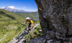
Photo Epic: The First Stone King Rally
Jul 6, 2022 from pinkbike.com
Sven Martin and Wills Harrison-Wright's photography takes you to the wild and raw Stone King Rally.
Popular Queyras Mountain Biking Trails
• 100 ★ 4.3 • 5 miles • 132 ft • 119 • • hike
Popular black difficulty singletrack. This hike primary trail can be used downhill primary and has a hard overall physical rating with a 132 ft black diamond climb. Trail visibility is always easy to follow. On average it takes 1 hour4 minutes to complete this trail.
• 95 ★ 4.0 • 1 mile • 0 ft • 33 •
Popular red difficulty singletrack. This multi-use trail can be used downhill only. On average it takes 11 minutes to complete this trail.
• 75 ★ 4.0 • 2 miles • 0 ft • 26 •
Popular red difficulty singletrack. This multi-use trail can be used downhill only. On average it takes 19 minutes to complete this trail.
• 90 ★ 0.0 • 1,939 ft • 36 ft • 23 •
Petit bout de sentier sympa et roulant sous les mélèzes
• 100 ★ 5.0 • 4,488 ft • 79 ft • 23 •
Trail created in 2015. Many switcbacks in forest.
• 5 ★ 0.0 • 1 mile • 41 ft • 15 •
Less popular red difficulty singletrack. This mountain bike primary trail can be used downhill only. On average it takes 8 minutes to complete this trail.
• 50 ★ 4.5 • 1 mile • 0 ft • 14 •
Moderately popular red difficulty singletrack. This multi-use trail can be used downhill only. On average it takes 27 minutes to complete this trail.
• 70 ★ 0.0 • 1 mile • 638 ft • 12 •
Steep climb on a singletrack, some parts you have to push or carry your bike, stunning view, and a 2900m pass. Montée raide sur un sentier, certaines parties ce pédale et d'autre il faudra pousser et porter le vélo ! Vue magnifique...
Photos of Queyras Mountain Bike
Videos of Queyras Mountain Bike

trail: Col Vieux des Lacs
13:11 |
6 |
May 26, 2026 , My City
Recent Trail Reports
| status | trail | date | condition | info | user |
|---|---|---|---|---|---|
| Coupe Piste 1 | May 30, 2026 @ 5:40pm (Europe/Paris) May 30, 2026 | Ideal | zestyman | ||
| Coupe Piste 2 | May 30, 2026 @ 5:36pm (Europe/Paris) May 30, 2026 | Ideal | zestyman | ||
| Col Vieux des Lacs | Sep 19, 2025 @ 8:19am (Europe/Monaco) Sep 18, 2025 | Ideal | Kajanda | ||
| Les esponces | Sep 18, 2025 @ 7:52am (Europe/Monaco) Sep 17, 2025 | Ideal | Kajanda | ||
| Piste Fort Claous | Jul 19, 2025 @ 12:06pm Jul 19, 2025 | Wet | freerider48 TRAILFORKS | ||
| Col Girardin : Versant N | Jun 14, 2025 @ 10:09am Jun 14, 2025 | Snow Cover Partial | zestyman | ||
| Bois de la Cube | Oct 6, 2024 @ 7:56am Oct 6, 2024 | Ideal | dterri Lo Podall | ||
| Pervou | Oct 8, 2024 @ 8:14am Oct 8, 2024 | Ideal | dterri Lo Podall | ||
| Piste du Col Valante | Sep 28, 2024 @ 9:34am Sep 28, 2024 | Ideal | Fab82 | ||
| Route Du Chateau Queyras | Aug 22, 2024 @ 11:18am Aug 22, 2024 | Dry | Tofito |
Activity Feed
| username | action | type | title | date |
|---|---|---|---|---|
| RogerNjynTK | wishlist | trail | activity #96815182 | Jun 12, 2026 @ 10:50am Jun 12, 2026 |
| cavalollo | wishlist | region | activity #96064158 | Jun 1, 2026 @ 11:10pm Jun 1, 2026 |
| zestyman | add | report | activity #95855935 and 2 more | May 30, 2026 @ 8:37am May 30, 2026 |
| zestyman | ridden | trail | activity #95855784 | May 30, 2026 @ 8:35am May 30, 2026 |
| zestyman | vote | trail | activity #95855776 and 1 more | May 30, 2026 @ 8:35am May 30, 2026 |
Recent Comments
| username | type | title | comment | date |
|---|---|---|---|---|
| trail | Good morning. I'm going to do the tour du... | Aug 12, 2024 @ 10:07am Aug 12, 2024 | ||
| trail | Well, you can ride it in early morning before... | Jun 27, 2024 @ 1:41pm Jun 27, 2024 | ||
| trail | All track is forbidden, or just some parts? If... | Jun 27, 2024 @ 9:39am Jun 27, 2024 | ||
| trail | It's now forbidden to ride this trail... | Aug 4, 2023 @ 5:01am Aug 4, 2023 | ||
| trail | sick trail....almost infinite..... | Aug 17, 2022 @ 1:55am Aug 17, 2022 |
Nearby Areas
| name | distance | ||||
|---|---|---|---|---|---|
| Arvieux | 1 | 7.9 km | |||
| Guillestre | 2 | 9.7 km | |||
| Abries Bike Park | 4 | 10 | 11 km | ||
| Champcella | 4 | 13.2 km | |||
| Val Pellice | 3 | 12 | 10 | 2 | 14.5 km |
Local Badges
-

Completionist0 awarded
Activity Type Stats
| activitytype | trails | distance | descent | descent distance | total vertical | rating | global rank | state rank | photos | reports | routes | ridelogs |
|---|---|---|---|---|---|---|---|---|---|---|---|---|
| Mountain Bike | 28 | 42 miles | 24,767 ft | 31 miles | 6,729 ft | #4,057 | #85 | 142 | 50 | 479 | ||
| E-Bike | 26 | 36 miles | 21,470 ft | 27 miles | 6,729 ft | #393 | #26 | 47 | 54 | |||
| Hike | 28 | 43 miles | 23,740 ft | 30 miles | 5,643 ft | #3,416 | #61 | 49 | 158 | |||
| Trail Running | 26 | 41 miles | 23,031 ft | 29 miles | 5,643 ft | #2,854 | #66 | 49 | 42 |
Frequently Asked Questions About Queyras
▼
What are the highest rated mountain biking trails in Queyras?
The highest rated mountain biking trails in Queyras are:
- Coupe Piste 2 (4.1/5)
- DH lac du Guil (4.1/5)
- Lac Sainte-Anne (4.1/5)
- Col Vieux des Lacs (4.1/5)
- Col Girardin : Versant N (4/5)
▼
What is the best time of the year to ride in Queyras?
Based on ride log data, the most popular months to ride in Queyras are:
- April (5 activities)
- August (5 activities)
- September (2 activities)
▼
Where can I park to ride in Queyras?
There are 3 parking locations listed in Queyras. The most popular parking spots are: View all parking and trailhead locations on the map to plan your visit.
▼
What is the longest trail in Queyras?
The longest trail in Queyras is Col Vieux des Lacs at 8.5 km. View all trails sorted by distance.
Activities
Trails
Points of Interest
- By hpman83
 TRAILFORKS TFFRANCE & contributors
 - Admins: tomzaniroli, freerider48, provencemb
- #31050 - 4,529 views
- queyras activity log | embed map of Queyras mountain bike trails | queyras mountain biking points of interest
Downloading of trail gps tracks in kml & gpx formats is enabled for Queyras.
You must login to download files.