close
-
Layers w
- Weather Layers
- Pro
- Pro
- Pro
- Pro
- Pro
- Pro
- More Layers
- Pro
- Pro
- Pro
- Pro
-
Upgrade to

3D
Trail Conditions
- Unknown
- Snow Groomed
- Snow Packed
- Snow Covered
- Snow Cover Partial
- Freeze/thaw Cycle
- Icy
- Prevalent Mud
- Wet
- Variable
- Ideal
- Dry
- Very Dry
Trail Flow (Ridden Direction)
Trailforks scans users ridelogs to determine the most popular direction each trail is ridden. A good flowing trail network will have most trails flowing in a single direction according to their intension.
The colour categories are based on what percentage of riders are riding a trail in its intended direction.
The colour categories are based on what percentage of riders are riding a trail in its intended direction.
- > 96%
- > 90%
- > 80%
- > 70%
- > 50%
- < 50%
- bi-directional trail
- no data
Trail Last Ridden
Trailforks scans ridelogs to determine the last time a trail was ridden.
- < 2 days
- < 1 week
- < 2 weeks
- < 1 month
- < 6 months
- > 6 months
Trail Ridden Direction
The intended direction a trail should be ridden.
- Downhill Only
- Downhill Primary
- Both Directions
- Uphill Primary
- Uphill Only
- One Direction
Contribute Details
Colors indicate trail is missing specified detail.
- Description
- Photos
- Description & Photos
- Videos
Trail Popularity ?
Trailforks scans ridelogs to determine which trails are ridden the most in the last 9 months.
Trails are compared with nearby trails in the same city region with a possible 25 colour shades.
Think of this as a heatmap, more rides = more kinetic energy = warmer colors.
- most popular
- popular
- less popular
- not popular
ATV/ORV/OHV Filter
Max Vehicle Width
inches
US Cell Coverage
Legend

Radar Time
Activity Recordings
Trailforks uses anonymized public activity data.
?
Activity Recordings
Trailforks uses anonymized public activity data.
?
Personal Heatmap
▶
Activity Types
all
/
none
▶
Options
2
Date range
month
–
Winter Trails
Warning
A routing network for winter maps does not exist. Selecting trails using the winter trails layer has been disabled.
Missing Trails
Most Popular
Least Popular
Trails are colored based on popularity. The more popular a trail is, the more red. Less popular trails trend towards green.
Jump Magnitude Heatmap
Heatmap of where riders jump on trails. Zoom in to see individual jumps, click circles to view jump details.
BC Backroad Status
![map legend]()
Service Road Atlas is a free to use, community-driven service for viewing and creating reports on the numerous back-country service roads around B.C. and Alberta.

Slope Aspect
Direction the slope faces
Trails Deemphasized
Trails are shown in grey.
Only show trails with no bike usage.
Suggested Layers
Based on selected activity type
Save the current map location and zoom level as your default home location whenever this page is loaded.
Save
No description for Ravenna has been added yet!
Login or register to submit one.
This region uses the Uk/Euro style trail grading system.
Activities Click to view
- Mountain Bike
62 trails
- E-Bike
51 trails
- Horse
9 trails
- Hike
60 trails
- Trail Running
61 trails
Region Details
- 15
- 3
- 16
- 17
Stats
- Avg Trail Rating
- Trails (view details)
- 60
- Trails Mountain Bike
- 62
- Trails E-Bike
- 51
- Trails Horse
- 9
- Trails Hike
- 60
- Trails Trail Running
- 61
- Total Distance
- 66 miles
- Total Descent
- 16,133 ft
- Total Vertical
- 1,533 ft
- Highest Trailhead
- 1,768 ft
- Reports
- 626
- Photos
- 26
- Ridden Counter
- 2,592
Sub Regions
Popular Ravenna Mountain Biking Trails
• 100 ★ 2.3 • 2,940 ft • 5 ft • 72 •
Popular green difficulty dirt/gravel road. This mountain bike primary trail can be used both directions and has a easy overall physical rating with a 5 ft green climb. It features other. Trail visibility is always easy to follow. On average it takes 3 minutes to complete this trail.
• 85 ★ 4.4 • 1 mile • 162 ft • 71 •
Popular green difficulty singletrack. This mountain bike primary trail can be used downhill primary and has a hard overall physical rating with a 162 ft black diamond climb. It features skinny. On average it takes 12 minutes to complete this trail.
• 80 ★ 4.8 • 4,577 ft • 109 ft • 68 •
Highly rated popular blue difficulty singletrack. This mountain bike primary trail can be used downhill primary and has a easy overall physical rating with a 109 ft black diamond climb. It features rock garden and skinny. On average it takes 10 minutes to complete this trail.
• 95 ★ 4.5 • 3,871 ft • 26 ft • 62 •
Highly rated popular blue difficulty singletrack. This mountain bike primary trail can be used downhill only. It features rock garden and skinny. Trail visibility is always easy to follow. On average it takes 6 minutes to complete this trail.
• 95 ★ 4.3 • 925 ft • 0 ft • 60 •
Popular blue difficulty singletrack. This mountain bike primary trail can be used downhill only with a 0 ft black diamond climb. It features rock face and rock garden. On average it takes 1 minutes to complete this trail.
• 95 ★ 3.8 • 1,749 ft • 230 ft • 51 •
Dalla sella di Ca' faggia per ritornare sulla strada che risale a Monte Mauro. La prima parte è salita dura e tecnica, poi scende per un breve ma molto divertente nel bosco.
• 85 ★ 4.5 • 558 ft • 0 ft • 40 •
Highly rated popular red difficulty singletrack. This mountain bike primary trail can be used downhill only. It features rock face and rock garden. On average it takes 2 minutes to complete this trail.
• 45 ★ 4.0 • 2,789 ft • 30 ft • 40 •
Moderately popular green difficulty singletrack. This mountain bike primary trail can be used both directions and has a moderate overall physical rating with a 30 ft blue climb. It features skinny. Trail visibility is always easy to follow. On average it takes 3 minutes to complete this trail.
Ravenna Mountain Bike Routes
29 miles • 4,237 ft • 0 •
Giro a M.te Mauro, M.te Albano fino a Casola Valsenio.
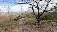
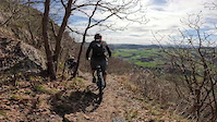
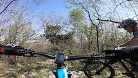
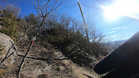
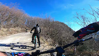
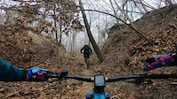
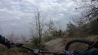
Photos of Ravenna Mountain Bike
Videos of Ravenna Mountain Bike
trail: Monte Volpe
4:01 |
13 |
Mar 14, 2026
trail: Lucerna Trail
5:49 |
17 |
Mar 14, 2026

trail: Destra Chiesa
0:02 |
15 |
Apr 6, 2025
trail: Ca Faggia Freeride
2:57 |
16 |
Apr 6, 2025
trail: Sentiero dei Cristalli
6:00 |
79 |
Feb 6, 2024
trail: Lucerna Trail
6:50 |
89 |
Feb 6, 2024
trail: Covid Trail
4:08 |
29 |
Dec 31, 2023
trail: Monte Volpe
4:05 |
76 |
Dec 31, 2023
Recent Trail Reports
Activity Feed
| username | action | type | title | date |
|---|---|---|---|---|
| gion86 | add | report | activity #96962960 and 1 more | Jun 14, 2026 @ 6:43am Jun 14, 2026 |
| gpaoloconti | add | report | activity #95856073 and 10 more | May 30, 2026 @ 8:39am May 30, 2026 |
| gion86 | add | report | activity #95407466 | May 24, 2026 @ 7:26am May 24, 2026 |
| Crimoponfo | vote | trail | activity #93534480 and 6 more | Apr 27, 2026 @ 12:33pm Apr 27, 2026 |
| gab-pulga | add | report | activity #91839255 and 19 more | Apr 3, 2026 @ 11:44am Apr 3, 2026 |
Recent Comments
| username | type | title | comment | date |
|---|---|---|---|---|
| trail | Prima parte molto bella su roccia, poi nel... | Mar 14, 2026 @ 3:14pm Mar 14, 2026 | ||
| trail | Non difficile e divertente, il dolcetto a fine... | Mar 14, 2026 @ 2:48pm Mar 14, 2026 | ||
| trail | Forse il più bello della zona, un mix di... | Mar 14, 2026 @ 2:44pm Mar 14, 2026 | ||
| trail | Livello tecnico S2 con un paio di ripidi quasi... | Nov 17, 2025 @ 11:33pm Nov 17, 2025 | ||
| trail | Livello generale S2/S3, con parte iniziale... | Nov 17, 2025 @ 11:30pm Nov 17, 2025 |
Local Badges
-

Completionist0 awarded
Bike & Skill Parks
| name | type | city | rating |
|---|---|---|---|
| Crossdromo Ravenna | skill park | Ravenna | |
| Faenza MX | skill park | ||
| San Giuseppe-Pomposa | skill park | Ravenna | |
| Crossdromo Baracca (Lugo) | skill park |
Activity Type Stats
| activitytype | trails | distance | descent | descent distance | total vertical | rating | global rank | state rank | photos | reports | routes | ridelogs |
|---|---|---|---|---|---|---|---|---|---|---|---|---|
| Mountain Bike | 62 | 66 miles | 16,132 ft | 32 miles | 1,532 ft | 24 | 626 | 2 | 5,282 | |||
| E-Bike | 51 | 52 miles | 14,229 ft | 26 miles | 1,532 ft | 2 | 610 | 1 | 1,221 | |||
| Horse | 9 | 12 miles | 3,684 ft | 7 miles | 1,299 ft | 4 | ||||||
| Hike | 60 | 65 miles | 15,007 ft | 30 miles | 1,532 ft | 610 | 71 | |||||
| Trail Running | 61 | 66 miles | 15,646 ft | 31 miles | 1,532 ft | 622 | 40 |
Frequently Asked Questions About Ravenna
▼
What are the best places to ride in Ravenna?
Ravenna has 1 areas to explore for mountain biking. The top rated areas are:
▼
What are the highest rated mountain biking trails in Ravenna?
The highest rated mountain biking trails in Ravenna are:
- Monte Volpe (4.5/5)
- Sentiero dei Cristalli (4.5/5)
- Vedove (4.4/5)
- Lucerna Trail (4.3/5)
- Doraimon (4.3/5)
▼
What is the best time of the year to ride in Ravenna?
Based on ride log data, the most popular months to ride in Ravenna are:
- July (32 activities)
- September (27 activities)
- May (25 activities)
▼
What is the longest trail in Ravenna?
The longest trail in Ravenna is Argine degli Angeli at 9.3 miles. View all trails sorted by distance.
Activities
- By denitopia
 TRAILFORKS VTA & contributors
 - Admins: denitopia, marcoangeletti, cemoorelife
- #11677 - 2,021 views
- ravenna activity log | embed map of Ravenna mountain bike trails | ravenna mountain biking points of interest
Downloading of trail gps tracks in kml & gpx formats is enabled for Ravenna.
You must login to download files.