close
-
Layers w
- Weather Layers
- Pro
- Pro
- Pro
- Pro
- Pro
- Pro
- More Layers
- Pro
- Pro
- Pro
- Pro
-
Upgrade to

3D
Trail Conditions
- Unknown
- Snow Groomed
- Snow Packed
- Snow Covered
- Snow Cover Partial
- Freeze/thaw Cycle
- Icy
- Prevalent Mud
- Wet
- Variable
- Ideal
- Dry
- Very Dry
Trail Flow (Ridden Direction)
Trailforks scans users ridelogs to determine the most popular direction each trail is ridden. A good flowing trail network will have most trails flowing in a single direction according to their intension.
The colour categories are based on what percentage of riders are riding a trail in its intended direction.
The colour categories are based on what percentage of riders are riding a trail in its intended direction.
- > 96%
- > 90%
- > 80%
- > 70%
- > 50%
- < 50%
- bi-directional trail
- no data
Trail Last Ridden
Trailforks scans ridelogs to determine the last time a trail was ridden.
- < 2 days
- < 1 week
- < 2 weeks
- < 1 month
- < 6 months
- > 6 months
Trail Ridden Direction
The intended direction a trail should be ridden.
- Downhill Only
- Downhill Primary
- Both Directions
- Uphill Primary
- Uphill Only
- One Direction
Contribute Details
Colors indicate trail is missing specified detail.
- Description
- Photos
- Description & Photos
- Videos
Trail Popularity ?
Trailforks scans ridelogs to determine which trails are ridden the most in the last 9 months.
Trails are compared with nearby trails in the same city region with a possible 25 colour shades.
Think of this as a heatmap, more rides = more kinetic energy = warmer colors.
- most popular
- popular
- less popular
- not popular
ATV/ORV/OHV Filter
Max Vehicle Width
inches
US Cell Coverage
Legend

Radar Time
Activity Recordings
Trailforks uses anonymized public activity data.
?
Activity Recordings
Trailforks uses anonymized public activity data.
?
Personal Heatmap
▶
Activity Types
all
/
none
▶
Options
2
Date range
month
–
Winter Trails
Warning
A routing network for winter maps does not exist. Selecting trails using the winter trails layer has been disabled.
Missing Trails
Most Popular
Least Popular
Trails are colored based on popularity. The more popular a trail is, the more red. Less popular trails trend towards green.
Jump Magnitude Heatmap
Heatmap of where riders jump on trails. Zoom in to see individual jumps, click circles to view jump details.
BC Backroad Status
![map legend]()
Service Road Atlas is a free to use, community-driven service for viewing and creating reports on the numerous back-country service roads around B.C. and Alberta.

Slope Aspect
Direction the slope faces
Trails Deemphasized
Trails are shown in grey.
Only show trails with no bike usage.
Suggested Layers
Based on selected activity type
Save the current map location and zoom level as your default home location whenever this page is loaded.
Save
No description for Ravensburg has been added yet!
Login or register to submit one.
This region uses the Uk/Euro style trail grading system.
Activities Click to view
- Mountain Bike
44 trails
- E-Bike
44 trails
- Adaptive Bike
0 trails
- Hike
37 trails
- Trail Running
37 trails
Region Details
- 9
- 1
- 18
- 10
- 2
- 2
Region Status
Open as of 23 hoursStats
- Avg Trail Rating
- Trails (view details)
- 42
- Trails Mountain Bike
- 44
- Trails E-Bike
- 44
- Trails Horse
- 2
- Trails Hike
- 37
- Trails Trail Running
- 37
- Total Distance
- 16 miles
- Total Descent
- 2,928 ft
- Total Vertical
- 636 ft
- Highest Trailhead
- 2,217 ft
- Reports
- 140
- Photos
- 21
- Ridden Counter
- 872
Popular Ravensburg Mountain Biking Trails
• 100 ★ 4.7 • 1,765 ft • 2 ft • 90 •
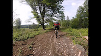
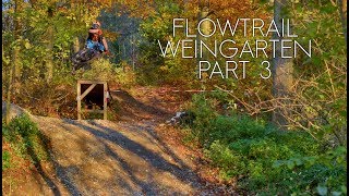
Flowtrail Weingarten is a public trail operated by the Radfahrer-Verein Weingarten and the city of Weingarten. The Flowtrail is a fast, fun and fairly wide trail with lots of berms, rollers and jumps and consists out of three sections....
• 100 ★ 4.0 • 922 ft • 0 ft • 52 •
Popular blue difficulty singletrack. This mountain bike primary trail can be used downhill primary and has a easy overall physical rating with a 0 ft blue climb. It features jump. Trail visibility is always easy to follow. On average it takes minutes to complete this trail.
• 85 ★ 5.0 • 890 ft • 2 ft • 45 •
The final section of the Kickach-Trail. Some rocky sections and one steep rocky section. A little double at the beginning and jump at the end.
• 50 ★ 5.0 • 3 miles • 397 ft • 35 •
Moderately popular green difficulty singletrack. This mountain bike primary trail can be used both directions. It features jump. On average it takes 45 minutes to complete this trail.
• 90 ★ 4.0 • 377 ft • 0 ft • 33 •
Easy short trail. Trail ends above the wastewater treatment plant (Kläralag)
• 55 ★ 0.0 • 1,581 ft • 2 ft • 31 •
Flowy trail with some sharp corners and small climbs. Make a whole lot of fun if you power through it.
• 40 ★ 4.5 • 3,168 ft • 5 ft • 31 •
Funny singletrack with roots and smal jumps
• 40 ★ 3.0 • 535 ft • 0 ft • 30 •
Moderately popular green difficulty singletrack. This mountain bike primary trail can be used downhill primary and has a easy overall physical rating with a 0 ft blue climb. Trail visibility is always easy to follow. On average it takes minutes to complete this trail.
Photos of Ravensburg Mountain Bike
Videos of Ravensburg Mountain Bike

trail: Flowtrail Weingarten
3:04 |
463 |
Nov 7, 2017
trail: Flowtrail Weingarten
6:06 |
449 |
May 30, 2015
youtuber
![black segment - Flowtrail Weingarten]()
trail: Flowtrail Weingarten
3:58 |
875 |
Jun 17, 2018 , Ravensburg
Recent Trail Reports
| status | trail | date | condition | info | user |
|---|---|---|---|---|---|
| Parkplatz Lanzenreute | Oct 17, 2025 @ 3:41pm (Europe/Vaduz) Oct 17, 2025 | Unknown | Bunnyhop0815 | ||
| Kläranlagentrail 1 | Oct 17, 2025 @ 3:41pm (Europe/Vaduz) Oct 17, 2025 | Wet | Bunnyhop0815 | ||
| O(range)-Line | Oct 17, 2025 @ 3:41pm (Europe/Vaduz) Oct 17, 2025 | Unknown | Bunnyhop0815 | ||
| Zufahrt Orange-Line | Oct 17, 2025 @ 3:41pm (Europe/Vaduz) Oct 17, 2025 | Unknown | Bunnyhop0815 | ||
| Alp(L)ine - Alpine Line | Mar 3, 2025 @ 12:28pm Mar 3, 2025 | Variable | Bunnyhop0815 | ||
| Fox Trail | Mar 29, 2024 @ 2:11pm Mar 29, 2024 | Dry | Bunnyhop0815 | ||
| Saubadtrail | Feb 7, 2024 @ 5:47am Feb 7, 2024 | Variable | VanToff | ||
| Flowtrail Weingarten | May 18, 2023 @ 2:57am May 18, 2023 | Variable | Pwegmann | ||
| Albertshofen Jumpline | Oct 25, 2022 @ 12:36am Oct 25, 2022 | Variable | ekanoianer | ||
| Kickach Section 3 (Regular Final Section) | Oct 17, 2022 @ 1:06am Oct 17, 2022 | Variable | ekanoianer |
Activity Feed
| username | action | type | title | date |
|---|---|---|---|---|
| sutbalazs | ridden | trail | activity #95131660 | May 20, 2026 @ 1:58pm May 20, 2026 |
| michikautt | add | trail | activity #94627294 and 3 more | May 13, 2026 @ 7:55am May 13, 2026 |
| Hmncrshpd | ridden | trail | activity #93598728 | Apr 28, 2026 @ 12:25pm Apr 28, 2026 |
| Hmncrshpd | ridden | trail | activity #93355495 | Apr 25, 2026 @ 7:49am Apr 25, 2026 |
| Hmncrshpd | ridden | trail | activity #92778042 and 1 more | Apr 17, 2026 @ 4:12am Apr 17, 2026 |
Recent Comments
| username | type | title | comment | date |
|---|---|---|---|---|
| report | Alles wieder perfekt…, unglaublich | Mar 29, 2024 @ 2:10pm Mar 29, 2024 | ||
| trail | Super Trail. XC lastig mit verschiedenen... | Jan 11, 2024 @ 1:25am Jan 11, 2024 | ||
| trail | Updated... | Oct 13, 2023 @ 1:08pm Oct 13, 2023 | ||
| trail | Leider nicht mehr vorhanden. Oben links auf... | Aug 4, 2023 @ 1:37pm Aug 4, 2023 | ||
| trail | Öl | Jul 7, 2023 @ 12:47pm Jul 7, 2023 |
Local Badges
-

Epic Mountain Bike Climb 2k15 awarded -

Climbing 10k Badge8 awarded -

Mountain Biking 100k Badge0 awarded -

Epic Ride Descent 2k15 awarded -

Descent 10k Badge8 awarded -

Descent 100k Badge0 awarded
Activity Type Stats
| activitytype | trails | distance | descent | descent distance | total vertical | rating | global rank | state rank | photos | reports | routes | ridelogs |
|---|---|---|---|---|---|---|---|---|---|---|---|---|
| Mountain Bike | 44 | 16 miles | 2,927 ft | 8 miles | 636 ft | #4,034 | #65 | 20 | 140 | 1,995 | ||
| E-Bike | 44 | 16 miles | 2,927 ft | 8 miles | 636 ft | #3,445 | #81 | 1 | 130 | 506 | ||
| Horse | 2 | 4,039 ft | 59 ft | 1,417 ft | 194 ft | 22 | ||||||
| Hike | 37 | 16 miles | 2,605 ft | 7 miles | 636 ft | #5,846 | #64 | 133 | 59 | |||
| Trail Running | 37 | 16 miles | 2,605 ft | 7 miles | 636 ft | #5,274 | #62 | 133 | 52 |
Frequently Asked Questions About Ravensburg
▼
What are the highest rated mountain biking trails in Ravensburg?
The highest rated mountain biking trails in Ravensburg are:
- Flowtrail Weingarten (4.4/5)
- Saubadtrail (4.2/5)
- Kickach Section 3 (Regular Final Section) (4.1/5)
- Eckbach Trail (Alternative Kickach Final) (4.1/5)
- 3-Herzen (Klein-Kickach) (4.1/5)
▼
What is the best time of the year to ride in Ravensburg?
Based on ride log data, the most popular months to ride in Ravensburg are:
- April (12 activities)
- July (11 activities)
- May (9 activities)
▼
Where can I park to ride in Ravensburg?
Check the Ravensburg trail map for trailhead and parking information. Community members regularly update access and parking details for trails in the area.
▼
What is the longest trail in Ravensburg?
The longest trail in Ravensburg is Saubadtrail at 2.5 miles. View all trails sorted by distance.
Activities
Trails
Points of Interest
- By gryphon85 & contributors
- Admins: HDRiders, Sasse82, sp00n82, martywis
- #5927 - 7,209 views
- ravensburg activity log | embed map of Ravensburg mountain bike trails |
Downloading of trail gps tracks in kml & gpx formats is enabled for Ravensburg.
You must login to download files.