close
-
Layers w
- Weather Layers
- Pro
- Pro
- Pro
- Pro
- Pro
- Pro
- More Layers
- Pro
- Pro
- Pro
- Pro
-
Upgrade to

3D
Trail Conditions
- Unknown
- Snow Groomed
- Snow Packed
- Snow Covered
- Snow Cover Partial
- Freeze/thaw Cycle
- Icy
- Prevalent Mud
- Wet
- Variable
- Ideal
- Dry
- Very Dry
Trail Flow (Ridden Direction)
Trailforks scans users ridelogs to determine the most popular direction each trail is ridden. A good flowing trail network will have most trails flowing in a single direction according to their intension.
The colour categories are based on what percentage of riders are riding a trail in its intended direction.
The colour categories are based on what percentage of riders are riding a trail in its intended direction.
- > 96%
- > 90%
- > 80%
- > 70%
- > 50%
- < 50%
- bi-directional trail
- no data
Trail Last Ridden
Trailforks scans ridelogs to determine the last time a trail was ridden.
- < 2 days
- < 1 week
- < 2 weeks
- < 1 month
- < 6 months
- > 6 months
Trail Ridden Direction
The intended direction a trail should be ridden.
- Downhill Only
- Downhill Primary
- Both Directions
- Uphill Primary
- Uphill Only
- One Direction
Contribute Details
Colors indicate trail is missing specified detail.
- Description
- Photos
- Description & Photos
- Videos
Trail Popularity ?
Trailforks scans ridelogs to determine which trails are ridden the most in the last 9 months.
Trails are compared with nearby trails in the same city region with a possible 25 colour shades.
Think of this as a heatmap, more rides = more kinetic energy = warmer colors.
- most popular
- popular
- less popular
- not popular
ATV/ORV/OHV Filter
Max Vehicle Width
inches
US Cell Coverage
Legend

Radar Time
Activity Recordings
Trailforks uses anonymized public activity data.
?
Activity Recordings
Trailforks uses anonymized public activity data.
?
Personal Heatmap
▶
Activity Types
all
/
none
▶
Options
2
Date range
month
–
Winter Trails
Warning
A routing network for winter maps does not exist. Selecting trails using the winter trails layer has been disabled.
Missing Trails
Most Popular
Least Popular
Trails are colored based on popularity. The more popular a trail is, the more red. Less popular trails trend towards green.
Jump Magnitude Heatmap
Heatmap of where riders jump on trails. Zoom in to see individual jumps, click circles to view jump details.
BC Backroad Status
![map legend]()
Service Road Atlas is a free to use, community-driven service for viewing and creating reports on the numerous back-country service roads around B.C. and Alberta.

Slope Aspect
Direction the slope faces
Trails Deemphasized
Trails are shown in grey.
Only show trails with no bike usage.
Suggested Layers
Based on selected activity type
Save the current map location and zoom level as your default home location whenever this page is loaded.
Save
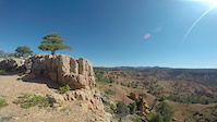
No description for Red Canyon has been added yet!
Login or register to submit one.
 google parking directions
Primary Trail Type: Cross-Country
Land Status: National Forest
google parking directionsLinks
Activities Click to view
- Mountain Bike
20 trails
- E-Bike
4 trails
- Horse
10 trails
- Hike
27 trails
- Trail Running
27 trails
- Dirtbike/Moto
4 trails
- ATV/ORV/OHV
4 trails
Region Details
- 9
- 1
- 2
- 5
- 2
Region Status
Caution as of May 31, 2026Stats
- Avg Trail Rating
- Trails (view details)
- 27
- Trails Mountain Bike
- 21
- Trails E-Bike
- 4
- Trails Horse
- 10
- Trails Hike
- 27
- Trails Trail Running
- 27
- Trails Dirtbike/Moto
- 4
- Trails ATV/ORV/OHV
- 4
- Total Distance
- 70 miles
- Total Descent
- 7,145 ft
- Total Vertical
- 1,945 ft
- Highest Trailhead
- 9,023 ft
- Reports
- 239
- Photos
- 587
- Ridden Counter
- 9,144
Articles

Bike-to-Climb Is Taking Off. Here’s How to Start.
Apr 18, 2025 from climbing.com
Enjoy the journey and reduce your impact with ecopointing
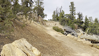
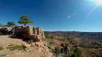
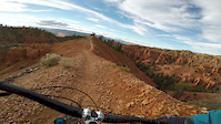
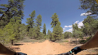
Popular Red Canyon Mountain Biking Trails
• 100 ★ 4.7 • 8 miles • 751 ft • 3,182 •
Trail is best known for its amazing scenery reminiscent of its neighbor Bryce Canyon. If you have ever wanted to ride terrain like Bryce Canyon and Cedar Breaks, this is the place. Red rock and smooth singletrack mixed in with some...
• 85 ★ 3.0 • 13 miles • 770 ft • 325 •
The Red Canyon Bicycle Trail (a National Recreation Trail), running for more than 8 paved miles, is appropriately named. This must-do path travels through scenic red canyons in an area referred to as "Little Bryce," after the nearby...
• 90 ★ 4.1 • 8 miles • 1,663 ft • 299 •
The Trail is a little-known but awesome ride. The trail is upper-intermediate technical, moderate aerobic. Trailhead is at 7200 feet, rising to 7900. The trail starts on Highway 12 in Red Canyon, and connects to the Canyon and Canyon...
• 95 ★ 3.2 • 3 miles • 0 ft • 271 •
An easy moderate climb to connect to , doesn't have the views of but still gives some nice rock formations. Mostly frequented by horseback riders as they have torn up the hard pack making most of the trail quite soft and loose. it looks...
• 90 ★ 3.0 • 2,829 ft • 120 ft • 198 •
Popular blue difficulty singletrack. This mountain bike primary trail can be used both directions. On average it takes 10 minutes to complete this trail.
• 85 ★ 4.4 • 2,041 ft • 81 ft • 178 •
The makes a nice loop when joined with the Trail. The has a pretty good climb. Once on top of the views are amazing. The first vista looks south into Red Canyon. The Trail then travels North and re joins the Cassity Trail. Stay to the...
• 85 ★ 3.8 • 2 miles • 480 ft • 174 •
This trail can be used in conjunction with the Trail #093 for half or all day trail rides or hikes. The beauty of the red rock formations and the variety of trees and vegetation are spectacular
• 80 ★ 0.0 • 3,451 ft • 36 ft • 111 •
This short but scenic trail passes through old growth ponderosa pine. It takes you to a viewpoint overlooking Red Canyon and Highway 12 to the south.
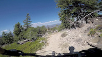
Red Canyon Mountain Bike Routes
Thunder Mountain Shuttle Yourself Featured
★ 3.8 • 15 miles • 1,767 ft • 2 • Loop •
This is the most common way to ride . There is a small percentage of people that like to ride it as an...
★ 4.0 • 16 miles • 1,901 ft • 2 •
Utah Relive Your Rides At the Panguitch End of Scenic Hwy 12 this is a MUST DO RIDE! While the scenic...
15 miles • 1,768 ft • 2 • Loop •
This is the most common way to ride . There is a small percentage of people that like to ride it as an...
28 miles • 2,571 ft • 2 • Point to Point •
Aquarius trail Day 2 Mountain Bike Route
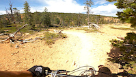
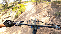
Photos of Red Canyon Mountain Bike
Videos of Red Canyon Mountain Bike
trail: Thunder Mountain
0:11 |
|
Jul 16, 2024
trail: Thunder Mountain
8:50 |
69 |
Jul 26, 2020
trail: Thunder Mountain
6:24 |
34 |
Jul 26, 2020
trail: Ledges Point
2:56 |
64 |
Jun 7, 2020
trail: Ledges Point
0:57 |
14 |
Jun 5, 2020
trail: Thunder Mountain
0:22 |
197 |
Sep 26, 2019
trail: Thunder Mountain
0:41 |
323 |
Jan 28, 2017
trail: Thunder Mountain
2:12 |
194 |
Jan 28, 2017
Recent Trail Reports
| status | trail | date | condition | info | user |
|---|---|---|---|---|---|
| Thunder Mountain | May 14, 2026 @ 6:29pm (America/Denver) May 14, 2026 | Unknown | kokopellikayaker | ||
| Coyote Hollow Road #113 | Dec 21, 2025 @ 11:35am (America/Phoenix) Dec 21, 2025 | Dry | mountainmaneuvers | ||
| Freemont ATV | Nov 14, 2025 @ 1:36pm (America/Denver) Nov 14, 2025 | Variable | ev-dog SDMBA | ||
| Losee Canyon | Nov 3, 2025 @ 12:11pm (America/Phoenix) Nov 3, 2025 | Ideal | bikems | ||
| Rich Trail #092 | Aug 10, 2025 @ 9:25am Aug 10, 2025 | Very Dry | mccsomthin | ||
| Cassidy | Jun 2, 2025 @ 9:38am Jun 2, 2025 | Dry | Hoontar | ||
| Marcus' Campground Loop | May 25, 2025 @ 10:20am May 25, 2025 | Dry | UtahJohn TRAILFORKS | ||
| Casto | Oct 12, 2024 @ 10:06am Oct 12, 2024 | Dry | mikebherpz | ||
| Ledges Point | May 25, 2024 @ 9:09am May 25, 2024 | Dry | Lindasiepert | ||
| Red Canyon Bike Trail | Oct 21, 2023 @ 10:22am Oct 21, 2023 | Ideal | ritzy114 |
Activity Feed
| username | action | type | title | date |
|---|---|---|---|---|
| Dsharpsand | wishlist | trail | activity #97296751 | Jun 18, 2026 @ 9:53pm 3 days |
| Jaime4hpjVT | wishlist | trail | activity #97294577 | Jun 18, 2026 @ 8:38pm 3 days |
| mid-c | wishlist | trail | activity #97244234 | Jun 18, 2026 @ 5:07am Jun 18, 2026 |
| eodjosh | wishlist | route | activity #97189906 | Jun 17, 2026 @ 9:31am Jun 17, 2026 |
| t0vGn | comment | route | activity #97003745 | Jun 14, 2026 @ 2:11pm Jun 14, 2026 |
Recent Comments
| username | type | title | comment | date |
|---|---|---|---|---|
| trail | Beautiful location. Boring ride. | Jun 1, 2026 @ 3:24pm Jun 1, 2026 | ||
| trail | Fun trail, thanks to the couple that was... | May 28, 2026 @ 5:54pm May 28, 2026 | ||
| trail | Perfect conditions at the end of March 2026.... | Mar 30, 2026 @ 9:35am Mar 30, 2026 | ||
| trail | With the big warm up, mud is becoming much... | Mar 19, 2026 @ 3:36pm Mar 19, 2026 | ||
| trail | Rode it for about the 5th time last week. A... | Oct 3, 2025 @ 12:47pm Oct 3, 2025 |
Nearby Areas
| name | distance | ||||
|---|---|---|---|---|---|
| Bryce Canyon National Park | 2 | 12.9 km | |||
| Mount Dutton | 1 | 2 | 3 | 17.2 km | |
| Paunsaugunt Plateau | 2 | 11 | 17 | 17.8 km | |
| Powell Point | 2 | 5 | 3 | 23 km | |
| Kodachrome Basin State Park | 2 | 23.5 km |
Activity Type Stats
| activitytype | trails | distance | descent | descent distance | total vertical | rating | global rank | state rank | photos | reports | routes | ridelogs |
|---|---|---|---|---|---|---|---|---|---|---|---|---|
| Mountain Bike | 20 | 63 miles | 5,906 ft | 26 miles | 1,946 ft | #2,789 | #969 | 557 | 239 | 7 | 5,395 | |
| E-Bike | 4 | 25 miles | 509 ft | 9 miles | 997 ft | #5,038 | #1,397 | 149 | 344 | |||
| Horse | 10 | 35 miles | 4,121 ft | 15 miles | 1,194 ft | #1,100 | #560 | 2 | 119 | 7 | ||
| Hike | 27 | 64 miles | 6,447 ft | 26 miles | 1,946 ft | #1,628 | #725 | 36 | 242 | 513 | ||
| Trail Running | 27 | 64 miles | 6,447 ft | 26 miles | 1,946 ft | #3,101 | #817 | 3 | 242 | 1 | 137 | |
| Dirtbike/Moto | 4 | 12 miles | 289 ft | 3 miles | 997 ft | #888 | #378 | 50 | 3 | |||
| ATV/ORV/OHV | 4 | 12 miles | 289 ft | 3 miles | 997 ft | #528 | #209 | 50 | 4 |
Frequently Asked Questions About Red Canyon
▼
What are the highest rated mountain biking trails in Red Canyon?
The highest rated mountain biking trails in Red Canyon are:
- Thunder Mountain (4.6/5)
- Rich Trail #092 (4.1/5)
- Cassidy (4/5)
- Johnson Canyon (4/5)
- Rich Trail (3.9/5)
▼
What is the best time of the year to ride in Red Canyon?
Based on ride log data, the most popular months to ride in Red Canyon are:
- October (111 activities)
- May (89 activities)
- June (89 activities)
▼
Where can I park to ride in Red Canyon?
There are 3 parking locations listed in Red Canyon. The most popular parking spots are: View all parking and trailhead locations on the map to plan your visit.
▼
What is the longest trail in Red Canyon?
The longest trail in Red Canyon is Red Canyon Bike Trail at 12.5 miles. View all trails sorted by distance.
Activities
Trails
Points of Interest
- By todd
 Trailforks & contributors
 - Admins: jkwilliamz, UtahJohn, jpmcghee, jasonmalczyk
- #4863 - 13,025 views
- red canyon activity log | embed map of Red Canyon mountain bike trails | red canyon mountain biking points of interest
Downloading of trail gps tracks in kml & gpx formats is enabled for Red Canyon.
You must login to download files.