close
-
Layers w
- Weather Layers
- Pro
- Pro
- Pro
- Pro
- Pro
- Pro
- More Layers
- Pro
- Pro
- Pro
- Pro
-
Upgrade to

3D
Trail Conditions
- Unknown
- Snow Groomed
- Snow Packed
- Snow Covered
- Snow Cover Partial
- Freeze/thaw Cycle
- Icy
- Prevalent Mud
- Wet
- Variable
- Ideal
- Dry
- Very Dry
Trail Flow (Ridden Direction)
Trailforks scans users ridelogs to determine the most popular direction each trail is ridden. A good flowing trail network will have most trails flowing in a single direction according to their intension.
The colour categories are based on what percentage of riders are riding a trail in its intended direction.
The colour categories are based on what percentage of riders are riding a trail in its intended direction.
- > 96%
- > 90%
- > 80%
- > 70%
- > 50%
- < 50%
- bi-directional trail
- no data
Trail Last Ridden
Trailforks scans ridelogs to determine the last time a trail was ridden.
- < 2 days
- < 1 week
- < 2 weeks
- < 1 month
- < 6 months
- > 6 months
Trail Ridden Direction
The intended direction a trail should be ridden.
- Downhill Only
- Downhill Primary
- Both Directions
- Uphill Primary
- Uphill Only
- One Direction
Contribute Details
Colors indicate trail is missing specified detail.
- Description
- Photos
- Description & Photos
- Videos
Trail Popularity ?
Trailforks scans ridelogs to determine which trails are ridden the most in the last 9 months.
Trails are compared with nearby trails in the same city region with a possible 25 colour shades.
Think of this as a heatmap, more rides = more kinetic energy = warmer colors.
- most popular
- popular
- less popular
- not popular
ATV/ORV/OHV Filter
Max Vehicle Width
inches
US Cell Coverage
Legend

Radar Time
Activity Recordings
Trailforks uses anonymized public activity data.
?
Activity Recordings
Trailforks uses anonymized public activity data.
?
Personal Heatmap
▶
Activity Types
all
/
none
▶
Options
2
Date range
month
–
Winter Trails
Warning
A routing network for winter maps does not exist. Selecting trails using the winter trails layer has been disabled.
Missing Trails
Most Popular
Least Popular
Trails are colored based on popularity. The more popular a trail is, the more red. Less popular trails trend towards green.
Jump Magnitude Heatmap
Heatmap of where riders jump on trails. Zoom in to see individual jumps, click circles to view jump details.
BC Backroad Status
![map legend]()
Service Road Atlas is a free to use, community-driven service for viewing and creating reports on the numerous back-country service roads around B.C. and Alberta.

Slope Aspect
Direction the slope faces
Trails Deemphasized
Trails are shown in grey.
Only show trails with no bike usage.
Suggested Layers
Based on selected activity type
Save the current map location and zoom level as your default home location whenever this page is loaded.
Save
No description for Redcliff has been added yet!
Login or register to submit one.
Activities Click to view
- Mountain Bike
26 trails
- E-Bike
1 trails
- Gravel Bike
0 trails
- Adaptive Bike
0 trails
- Hike
26 trails
- Trail Running
26 trails
Region Details
- 6
- 3
- 7
- 10
Region Status
Open as of Jun 8, 2026Local Trail Association
Stats
- Avg Trail Rating
- Trails (view details)
- 26
- Trails Mountain Bike
- 26
- Trails E-Bike
- 1
- Trails Hike
- 26
- Trails Trail Running
- 26
- Trails Snowshoe
- 1
- Total Distance
- 14 miles
- Total Descent
- 2,514 ft
- Total Vertical
- 267 ft
- Highest Trailhead
- 2,431 ft
- Reports
- 400
- Photos
- 166
- Ridden Counter
- 4,711
Popular Redcliff Mountain Biking Trails
• 95 ★ 4.4 • 1 mile • 240 ft • 366 •
Tequila is a feeder trail between and . The trail itself is fairly mild as it includes several bypasses around harder trails such as and .
• 100 ★ 4.0 • 2,246 ft • 106 ft • 320 •
Crossing the border between Medicine Hat and Redcliff, this trail is fun in both directions and contains a few small berms, rock features, and a water crossing. A great connector between two growing trail networks.
• 95 ★ 4.9 • 1 mile • 153 ft • 318 •
Although not quite as difficult as it once was, still provides a challenge with a few of its steep climbs and rough terrain. This trail provides users with a true badlands riding experience. The most difficult sections have a bypass...
• 65 ★ 4.4 • 1 mile • 143 ft • 270 •
Named after the slowly smoldering coal seam that collapsed part of the trail a few years back, is probably the most mild trail in the area. The trail was re-routed away from the problem spot but users still ride parallel to the old burn...
• 50 ★ 0.0 • 483 ft • 19 ft • 264 •
Nobody knows why its called Lumpy Gravy, but it is, and it will get you around a short punchy climb in the middle of .
• 100 ★ 0.0 • 1,526 ft • 30 ft • 235 •
Popular white difficulty paved path. This multi-use trail. On average it takes 1 minutes to complete this trail.
• 75 ★ 4.8 • 2,010 ft • 34 ft • 233 •
is a blue square machine built flow trail full of berms, rollers and the occasional table top jump. Perfect for riders of all skill levels. Is easily looped when connected with the climb, or by grinding up the west side gravel path. If...
• 80 ★ 5.0 • 2,704 ft • 110 ft • 228 •
A lot of people have asked who Carl is. Some have even asked why he is so vengeful. Very few know the real truth. Carl's is a great side loop on your way between Redcliff and Medicine Hat and it also makes a fun technical turn around...
Redcliff Mountain Bike Routes
15 miles • 2,098 ft • 18 • Loop •
Hardcore Cycling Club May long weekend 2023 Tentative ride plan
• 15 miles • 1,316 ft • 11 •
• 16 miles • 1,824 ft • 13 •
• 4 miles • 246 ft • 1 •
• 10 miles • 858 ft • 6 •
• 12 miles • 1,309 ft • 11 •
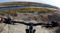
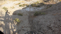
Photos of Redcliff Mountain Bike
Videos of Redcliff Mountain Bike
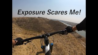
trail: Falcon Punch
0:14 |
321 |
Oct 12, 2020
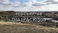
trail: Dialpack 500
0:19 |
319 |
Oct 4, 2020
trail: Dialpack 500
2:21 |
271 |
Oct 28, 2017

trail: Higher Learning
21:38 |
102 |
Sep 10, 2024 , Redcliff

trail: Old School
21:38 |
93 |
Sep 10, 2024 , Redcliff
21:38 |
70 |
Sep 10, 2024

trail: DMZ
0:31 |
233 |
Nov 1, 2021 , Redcliff

trail: Death Valley
0:31 |
355 |
Nov 1, 2021 , Redcliff
Recent Trail Reports
Activity Feed
| username | action | type | title | date |
|---|---|---|---|---|
| JBetke | wishlist | region | activity #95480806 | May 25, 2026 @ 5:44am May 25, 2026 |
| CJD49 | add | report | activity #92992531 and 13 more | Apr 19, 2026 @ 5:07pm Apr 19, 2026 |
| Wiltco1972 | ridden | trail | activity #89204523 | Feb 19, 2026 @ 6:05pm Feb 19, 2026 |
| deatg | wishlist | trail | activity #87821382 and 25 more | Jan 25, 2026 @ 3:12pm Jan 25, 2026 |
| verynicebike | wishlist | route | activity #84179024 | Nov 15, 2025 @ 8:28am Nov 15, 2025 |
Recent Comments
| username | type | title | comment | date |
|---|---|---|---|---|
| trail | From out of town? Ride this trail clockwise... | May 25, 2021 @ 1:37pm May 25, 2021 | ||
| trail | Really well built! | Apr 7, 2021 @ 5:10pm Apr 7, 2021 | ||
| trail | Great use of terrain and gradient to keep it fun. | Apr 7, 2021 @ 5:08pm Apr 7, 2021 | ||
| trail | Such a good trail! Punchy little climbs and... | Apr 7, 2021 @ 5:07pm Apr 7, 2021 | ||
| trail | I love this trail. Feels very Joshua Tree park... | May 18, 2020 @ 11:06am May 18, 2020 |
Local Badges
-

Epic Ride Climb 2k0 awarded -

Climbing 10k Badge18 awarded -

Climbing 100k Badge1 awarded -

Epic Ride Descent 2k0 awarded -

Descent 10k Badge18 awarded -

Descent 100k Badge2 awarded
Bike & Skill Parks
| name | type | city | rating |
|---|---|---|---|
| Redcliff Bike Skills Park | skill park | Redcliff |
Activity Type Stats
| activitytype | trails | distance | descent | descent distance | total vertical | rating | global rank | state rank | photos | reports | routes | ridelogs |
|---|---|---|---|---|---|---|---|---|---|---|---|---|
| Mountain Bike | 26 | 14 miles | 2,513 ft | 6 miles | 266 ft | #2,908 | #27 | 166 | 400 | 1 | 4,658 | |
| E-Bike | 1 | 1,447 ft | 52 ft | 335 ft | 72 ft | #6,231 | #43 | 296 | 87 | |||
| Hike | 26 | 14 miles | 2,513 ft | 6 miles | 266 ft | #6,876 | #44 | 388 | 137 | |||
| Trail Running | 26 | 14 miles | 2,513 ft | 6 miles | 266 ft | #6,093 | #39 | 388 | 219 | |||
| Snowshoe | 1 | 3,251 ft | 344 ft | 1,535 ft | 148 ft | 9 |
Frequently Asked Questions About Redcliff
▼
What are the highest rated mountain biking trails in Redcliff?
The highest rated mountain biking trails in Redcliff are:
- Death Valley (4.5/5)
- Dialpack 500 (4.4/5)
- Tombstone (4.3/5)
- Dirt Nap (4.2/5)
- Higher Learning (4.2/5)
▼
What is the best time of the year to ride in Redcliff?
Based on ride log data, the most popular months to ride in Redcliff are:
- July (91 activities)
- August (80 activities)
- May (68 activities)
▼
Where can I park to ride in Redcliff?
There are 1 parking locations listed in Redcliff. The most popular parking spots are:
▼
What is the longest trail in Redcliff?
The longest trail in Redcliff is River Valley Trail at 1.7 miles. View all trails sorted by distance.
- By kfbradley
 & contributors
 - Admins: kfbradley, CJD49, 670, mhatridr, kfbradley
- #8410 - 24,389 views
- redcliff activity log | embed map of Redcliff mountain bike trails | redcliff mountain biking points of interest
Downloading of trail gps tracks in kml & gpx formats is enabled for Redcliff.
You must login to download files.