close
-
Layers w
- Weather Layers
- Pro
- Pro
- Pro
- Pro
- Pro
- Pro
- More Layers
- Pro
- Pro
- Pro
- Pro
-
Upgrade to

3D
Trail Conditions
- Unknown
- Snow Groomed
- Snow Packed
- Snow Covered
- Snow Cover Partial
- Freeze/thaw Cycle
- Icy
- Prevalent Mud
- Wet
- Variable
- Ideal
- Dry
- Very Dry
Trail Flow (Ridden Direction)
Trailforks scans users ridelogs to determine the most popular direction each trail is ridden. A good flowing trail network will have most trails flowing in a single direction according to their intension.
The colour categories are based on what percentage of riders are riding a trail in its intended direction.
The colour categories are based on what percentage of riders are riding a trail in its intended direction.
- > 96%
- > 90%
- > 80%
- > 70%
- > 50%
- < 50%
- bi-directional trail
- no data
Trail Last Ridden
Trailforks scans ridelogs to determine the last time a trail was ridden.
- < 2 days
- < 1 week
- < 2 weeks
- < 1 month
- < 6 months
- > 6 months
Trail Ridden Direction
The intended direction a trail should be ridden.
- Downhill Only
- Downhill Primary
- Both Directions
- Uphill Primary
- Uphill Only
- One Direction
Contribute Details
Colors indicate trail is missing specified detail.
- Description
- Photos
- Description & Photos
- Videos
Trail Popularity ?
Trailforks scans ridelogs to determine which trails are ridden the most in the last 9 months.
Trails are compared with nearby trails in the same city region with a possible 25 colour shades.
Think of this as a heatmap, more rides = more kinetic energy = warmer colors.
- most popular
- popular
- less popular
- not popular
ATV/ORV/OHV Filter
Max Vehicle Width
inches
US Cell Coverage
Legend

Radar Time
Activity Recordings
Trailforks uses anonymized public activity data.
?
Activity Recordings
Trailforks uses anonymized public activity data.
?
Personal Heatmap
▶
Activity Types
all
/
none
▶
Options
2
Date range
month
–
Winter Trails
Warning
A routing network for winter maps does not exist. Selecting trails using the winter trails layer has been disabled.
Missing Trails
Most Popular
Least Popular
Trails are colored based on popularity. The more popular a trail is, the more red. Less popular trails trend towards green.
Jump Magnitude Heatmap
Heatmap of where riders jump on trails. Zoom in to see individual jumps, click circles to view jump details.
BC Backroad Status
![map legend]()
Service Road Atlas is a free to use, community-driven service for viewing and creating reports on the numerous back-country service roads around B.C. and Alberta.

Slope Aspect
Direction the slope faces
Trails Deemphasized
Trails are shown in grey.
Only show trails with no bike usage.
Suggested Layers
Based on selected activity type
Save the current map location and zoom level as your default home location whenever this page is loaded.
Save
No description for Redland City has been added yet!
Login or register to submit one.
Activities Click to view
- Mountain Bike
181 trails
- E-Bike
179 trails
- Gravel Bike
0 trails
- Adaptive Bike
0 trails
- Horse
61 trails
- Hike
174 trails
- Trail Running
173 trails
Region Details
- 81
- 2
- 53
- 33
- 2
Region Status
Open as of Jun 1, 2026Stats
- Avg Trail Rating
- Trails (view details)
- 171
- Trails Mountain Bike
- 181
- Trails E-Bike
- 179
- Trails Horse
- 61
- Trails Hike
- 174
- Trails Trail Running
- 173
- Total Distance
- 99 miles
- Total Descent
- 10,487 ft
- Total Vertical
- 701 ft
- Highest Trailhead
- 746 ft
- Reports
- 2,881
- Photos
- 503
- Ridden Counter
- 40,759
Sub Regions
-
Bayview Conservation Area
- 15
- 14
-
Eastern Escarpment Conservation Area
- 4
- 10
- 2
-
Emu Street Bushland Refuge
-
Greater Glider Conservation Area
- 1
-
Heinemann Road Conservation Area
-
Redlands Track Park
- 2
- 30
- 9
-
Sandy Creek Conservation Area
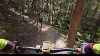
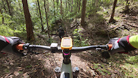
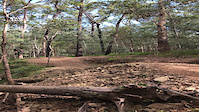
Popular Redland City Mountain Biking Trails
• 95 ★ 4.4 • 1 mile • 122 ft • 1,657 •
is a one-way trail, ridden from the hill at the top of toward the Main Day-use Area entrance. This more advanced trail rises and falls, and ‘surfs’ the terrain with climbing turns and descending berms.
• 95 ★ 3.9 • 1 mile • 166 ft • 1,576 •
is a one-way, easy, flowing trail. The trail gently climbs to it’s highest point, before it descends with switchbacks. It then flows along the valley floor to connect with Puck Rd.
• 100 ★ 5.0 • 2,287 ft • 2 ft • 1,527 •
is named after the Powerful Owl which is a notable bird species species in the reserve. Get ready to Howl with delight with the many small jumps double and singles on this trail. This trail is a first and privilege for the city to cater...
• 100 ★ 5.0 • 4,232 ft • 2 ft • 1,486 •
Flow down some wide packed trails and hit the clay packed berms and pumpy bumps. The fern gully down the bottom might catch out the average rider as it leads into a fall line but the armoured decent is pretty grippy with an easy climb...
• 100 ★ 4.7 • 4,009 ft • 227 ft • 1,442 •
provides an enjoyable climb to the downhill hub at the top of . For the trip down, there are small jump features, doubles and big berms to enjoy.
• 100 ★ 3.8 • 3,028 ft • 152 ft • 1,357 •
This trail joins the bottom of with the top of . It drops in and out of some steep ferny gullies so be prepared to use your speed wisely.
• 95 ★ 3.4 • 1,060 ft • 41 ft • 1,350 •
Popular green difficulty singletrack. This mountain bike primary trail can be used both directions with a 41 ft green climb. On average it takes 1 minutes to complete this trail.
• 90 ★ 4.3 • 2,362 ft • 98 ft • 1,259 •
Highly rated popular blue difficulty singletrack. This mountain bike primary trail can be used downhill primary and has a moderate overall physical rating with a 98 ft blue climb. It features berm. On average it takes 2 minutes to complete this trail.
Redland City Mountain Bike Routes
★ 5.0 • 12 miles • 887 ft • 11 • Loop •
This was my third time to Bayview. I planned this route to avoid the hardest trails ( and ). It still...
★ 3.7 • 17 miles • 1,107 ft • 13 • Loop •
Get back to Nature right in the heart of the Redlands Shire. Great mountain bike and walking trails for...
12 miles • 1,025 ft • 12 • Loop •
20km Loop from Ford Rd Car park. Heading down Wiry Panic, and over to Flying Cloud & Jim Finch before...
★ 4.0 • 9 miles • 893 ft • 18 • Loop •
nice not too hard route a Redlands track park
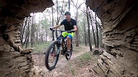
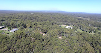
Photos of Redland City Mountain Bike
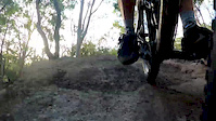
Videos of Redland City Mountain Bike
trail: Shenanigans
0:13 |
46 |
Dec 24, 2024
trail: Metamorphic A-line
0:16 |
10 |
Dec 24, 2024

trail: Blacking Out
12:26 |
87 |
May 13, 2022
trail: Shenanigans
11:00 |
86 |
May 12, 2022
trail: Blacking Out
0:06 |
|
May 2, 2022
trail: Whispering Woods
2:52 |
176 |
Aug 23, 2020
trail: Sorceress
3:00 |
340 |
Aug 23, 2020
trail: Wolf Peach
0:20 |
326 |
Jan 5, 2020
Current Trail Warnings
| status | trail | date | condition | user | info |
|---|---|---|---|---|---|
| Car Wash Link down | May 31, 2026 @ 5:49pm (Australia/Brisbane) May 31, 2026 | Wet | ngkdez | Tree down across track about 50m into track |
Recent Trail Reports
| status | trail | date | condition | info | user |
|---|---|---|---|---|---|
| Shenanigans | Jun 2, 2026 @ 11:18am (Australia/Brisbane) Jun 1, 2026 | Ideal | njf015 | ||
| Upper Main trail | Jun 2, 2026 @ 11:18am (Australia/Brisbane) Jun 1, 2026 | Ideal | njf015 | ||
| Powerful Howl | Jun 2, 2026 @ 11:18am (Australia/Brisbane) Jun 1, 2026 | Ideal | njf015 | ||
| Platypus Loop | May 24, 2026 @ 2:07pm (Australia/Brisbane) May 23, 2026 | Variable | dbrand87 | ||
| Whispering Woods | May 23, 2026 @ 6:02am (Australia/Brisbane) May 22, 2026 | Variable | ChrisWD | ||
| Cotton Canyon Part 1 | May 21, 2026 @ 10:41am (Australia/Brisbane) May 20, 2026 | Ideal | njf015 | ||
| Leo Lands | May 21, 2026 @ 10:41am (Australia/Brisbane) May 20, 2026 | Ideal | njf015 | ||
| Escalade | May 3, 2026 @ 10:15am (Australia/Brisbane) May 2, 2026 | Variable | lucascroft | ||
| Rise over Run | May 3, 2026 @ 10:15am (Australia/Brisbane) May 2, 2026 | Variable | lucascroft | ||
| Veloway 1 Gravatt - Nathan | Apr 26, 2026 @ 7:10am (Australia/Brisbane) Apr 25, 2026 | Wet | DavidQMITc3 |
Activity Feed
| username | action | type | title | date |
|---|---|---|---|---|
| DanielLp9HN6 | ridden | trail | activity #97971905 | Jun 28, 2026 @ 2:58am 1 day |
| Stevennoahseb | add | photo | activity #97951034 and 2 more | Jun 27, 2026 @ 5:52pm 2 days |
| theboomeranga03 | wishlist | route | activity #97653229 | Jun 23, 2026 @ 2:44pm Jun 23, 2026 |
| theboomeranga03 | add | route | activity #97559646 | Jun 22, 2026 @ 7:14am Jun 22, 2026 |
| Brod77 | comment | trail | activity #97357573 | Jun 19, 2026 @ 5:58pm Jun 19, 2026 |
Recent Comments
| username | type | title | comment | date |
|---|---|---|---|---|
| trail | Tree across track on grass tree link hard to... | Jun 19, 2026 @ 5:58pm Jun 19, 2026 | ||
| trail | If you don't take the loop that's a crazy... | May 23, 2026 @ 9:06pm May 23, 2026 | ||
| trail | Agree with others - southern end is relatively... | May 23, 2026 @ 9:05pm May 23, 2026 | ||
| trail | Some berms are very eroded. Not really... | Oct 9, 2025 @ 9:26pm Oct 9, 2025 | ||
| report | 🤣🤣❤️ | Sep 13, 2025 @ 4:32pm Sep 13, 2025 |
Local Badges
-

10 Blue Trails863 awarded -

Epic Mountain Bike Climb 2k41 awarded -

Climbing 10k Badge303 awarded -

Mountain Biking 100k Badge10 awarded -

Epic Ride Descent 2k41 awarded -

Descent 10k Badge304 awarded
Bike & Skill Parks
| name | type | city | rating |
|---|---|---|---|
| Bayview Skillpark | skill park | Redland City |
Activity Type Stats
| activitytype | trails | distance | descent | descent distance | total vertical | rating | global rank | state rank | photos | reports | routes | ridelogs |
|---|---|---|---|---|---|---|---|---|---|---|---|---|
| Mountain Bike | 181 | 99 miles | 10,486 ft | 46 miles | 702 ft | #150 | #10 | 459 | 2,853 | 38 | 79,505 | |
| E-Bike | 179 | 98 miles | 10,463 ft | 46 miles | 702 ft | #224 | #35 | 3 | 2,744 | 10 | 7,495 | |
| Horse | 61 | 39 miles | 3,579 ft | 18 miles | 702 ft | #812 | #39 | 339 | 24 | |||
| Hike | 174 | 92 miles | 9,577 ft | 42 miles | 702 ft | #1,239 | #46 | 40 | 2,820 | 1 | 1,600 | |
| Trail Running | 173 | 92 miles | 9,475 ft | 42 miles | 702 ft | #1,350 | #44 | 2,817 | 1 | 1,532 |
Frequently Asked Questions About Redland City
▼
What are the best places to ride in Redland City?
Redland City has 7 areas to explore for mountain biking. The top rated areas are:
▼
What are the highest rated mountain biking trails in Redland City?
The highest rated mountain biking trails in Redland City are:
- Powerful Howl (4.6/5)
- Westy's (4.5/5)
- Shenanigans (4.4/5)
- Blacking Out (4.4/5)
- Firing Line (4.3/5)
▼
What is the best time of the year to ride in Redland City?
Based on ride log data, the most popular months to ride in Redland City are:
- July (812 activities)
- August (694 activities)
- May (676 activities)
▼
Where can I park to ride in Redland City?
Activities
Trails
- By Trailsplanner
 & contributors
 - Admins: Jake-Hannah, Addzz, RedlandsCC
- #28815 - 4,529 views
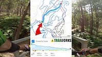
- redland city activity log | embed map of Redland City mountain bike trails | redland city mountain biking points of interest
Downloading of trail gps tracks in kml & gpx formats is enabled for Redland City.
You must login to download files.