close
-
Layers w
- Weather Layers
- Pro
- Pro
- Pro
- Pro
- Pro
- Pro
- More Layers
- Pro
- Pro
- Pro
- Pro
-
Upgrade to

3D
Trail Conditions
- Unknown
- Snow Groomed
- Snow Packed
- Snow Covered
- Snow Cover Partial
- Freeze/thaw Cycle
- Icy
- Prevalent Mud
- Wet
- Variable
- Ideal
- Dry
- Very Dry
Trail Flow (Ridden Direction)
Trailforks scans users ridelogs to determine the most popular direction each trail is ridden. A good flowing trail network will have most trails flowing in a single direction according to their intension.
The colour categories are based on what percentage of riders are riding a trail in its intended direction.
The colour categories are based on what percentage of riders are riding a trail in its intended direction.
- > 96%
- > 90%
- > 80%
- > 70%
- > 50%
- < 50%
- bi-directional trail
- no data
Trail Last Ridden
Trailforks scans ridelogs to determine the last time a trail was ridden.
- < 2 days
- < 1 week
- < 2 weeks
- < 1 month
- < 6 months
- > 6 months
Trail Ridden Direction
The intended direction a trail should be ridden.
- Downhill Only
- Downhill Primary
- Both Directions
- Uphill Primary
- Uphill Only
- One Direction
Contribute Details
Colors indicate trail is missing specified detail.
- Description
- Photos
- Description & Photos
- Videos
Trail Popularity ?
Trailforks scans ridelogs to determine which trails are ridden the most in the last 9 months.
Trails are compared with nearby trails in the same city region with a possible 25 colour shades.
Think of this as a heatmap, more rides = more kinetic energy = warmer colors.
- most popular
- popular
- less popular
- not popular
ATV/ORV/OHV Filter
Max Vehicle Width
inches
US Cell Coverage
Legend

Radar Time
Activity Recordings
Trailforks uses anonymized public activity data.
?
Activity Recordings
Trailforks uses anonymized public activity data.
?
Personal Heatmap
▶
Activity Types
all
/
none
▶
Options
2
Date range
month
–
Winter Trails
Warning
A routing network for winter maps does not exist. Selecting trails using the winter trails layer has been disabled.
Missing Trails
Most Popular
Least Popular
Trails are colored based on popularity. The more popular a trail is, the more red. Less popular trails trend towards green.
Jump Magnitude Heatmap
Heatmap of where riders jump on trails. Zoom in to see individual jumps, click circles to view jump details.
BC Backroad Status
![map legend]()
Service Road Atlas is a free to use, community-driven service for viewing and creating reports on the numerous back-country service roads around B.C. and Alberta.

Slope Aspect
Direction the slope faces
Trails Deemphasized
Trails are shown in grey.
Only show trails with no bike usage.
Suggested Layers
Based on selected activity type
Save the current map location and zoom level as your default home location whenever this page is loaded.
Save
No description for Redmond has been added yet!
Login or register to submit one.
Activities Click to view
- Mountain Bike
77 trails
- E-Bike
50 trails
- Gravel Bike
1 trails
- Adaptive Bike
1 trails
- Horse
17 trails
- Hike
106 trails
- Trail Running
106 trails
Region Details
- 11
- 8
- 46
- 6
- 1
Region Status
Open as of Jun 2, 2026Local Trail Association
Stats
- Avg Trail Rating
- Trails (view details)
- 103
- Trails Mountain Bike
- 77
- Trails E-Bike
- 50
- Trails Gravel Bike
- 1
- Trails Adaptive Bike
- 1
- Trails Horse
- 17
- Trails Hike
- 106
- Trails Trail Running
- 106
- Total Distance
- 53 miles
- Total Descent
- 4,069 ft
- Total Vertical
- 584 ft
- Highest Trailhead
- 611 ft
- Reports
- 279
- Photos
- 50
- Ridden Counter
- 11,910
Sub Regions
-
Farrel McWhirter Park
- 1
-
Hartman Park
- 1
- 7
- 1
- 1
-
Juel Community Park
- 1
-
Marymoor Park
-
Nike Park
- 2
- 2
- 2
-
Redmond Watershed Preserve
- 2
- 31
- 1
-
Willows Fjords
- 1
- 1
Popular Redmond Mountain Biking Trails
• 90 ★ 0.0 • 4,928 ft • 26 ft • 715 •
Gravel path that follows the powerlines. Mostly used as a connector trail that is part of the Thrilla route.
• 95 ★ 4.0 • 1 mile • 70 ft • 691 •
Connects the Tolt Trail with the . Majority of the trail consists of packed dirt with some sections of gravel. There is one street crossing.
• 100 ★ 0.0 • 4,173 ft • 55 ft • 599 •
Popular green difficulty singletrack. This multi-use trail can be used both directions. On average it takes 4 minutes to complete this trail.
• 65 ★ 3.0 • 2 miles • 163 ft • 537 •
Easy going dirt trail with some sections of gravel. The trail goes in and out of gullys with a couple tighter turns. Make sure not to go full speed as the trail has blind corners and is shared with hikers and equestrians. Not really...
• 95 ★ 4.0 • 640 ft • 2 ft • 243 •
Mainly used as a perimeter walking trail but is also fun to fly through on a bike.
• 90 ★ 3.0 • 1 mile • 25 ft • 235 •
Popular green difficulty family friendly gravel path. This multi-use trail can be used both directions and has a easy overall physical rating with a 25 ft green climb. On average it takes 8 minutes to complete this trail.
• 85 ★ 0.0 • 3,520 ft • 31 ft • 218 •
Some areas of bigger crushed rock that is lose on the trail/road
Redmond Mountain Bike Routes
★ 4.0 • 18 miles • 809 ft • 1 • Loop •
Primarily double track and paved bike trail, with some wide singletrack through the Redmond watershed....
★ 4.0 • 5 miles • 322 ft • 4 • Loop •
Easygoing loop around the Redmond Watershed Preserve. The trail is two-way and is multi-use, so watch for...
4 miles • 925 ft • 0 • Out & Back •
Short-but-challenging twisty singletrack in the dense woods just west of Willows Road in Redmond. Steep...
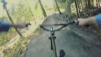
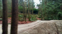
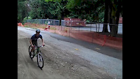
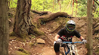
Photos of Redmond Mountain Bike
Videos of Redmond Mountain Bike

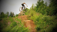
trail: Shredmond
0:42 |
61 |
Sep 8, 2023

trail: Easy-A
3:08 |
393 |
May 15, 2017
trail: Outer Space
0:02 |
512 |
Mar 9, 2015
trail: Outer Space
0:14 |
346 |
Dec 23, 2014
trail: Outer Space
2:01 |
650 |
Jul 23, 2014

trail: Diamonds
0:57 |
561 |
Nov 13, 2013
trail: Diamonds
2:20 |
59578 |
Aug 9, 2011
trail: Diamonds
2:06 |
899 |
Jun 24, 2011
Recent Trail Reports
| status | trail | date | condition | info | user |
|---|---|---|---|---|---|
| West Sammamish river trail | Jun 2, 2026 @ 3:12pm (America/Los_Angeles) Jun 2, 2026 | Ideal | amckech | ||
| Collin Creek Trail | Mar 23, 2026 @ 6:23pm (America/Los_Angeles) Mar 23, 2026 | Variable | kayakbiker | ||
| Redmond Central Connector | Mar 20, 2026 @ 12:51pm (America/Los_Angeles) Mar 20, 2026 | Ideal | badfishnomad | ||
| Farrel McWhirter To Watershed | Dec 19, 2025 @ 1:20pm (America/Vancouver) Dec 19, 2025 | Wet | Joannax2OVCa | ||
| Pipeline-Watershed Connector Trail | Dec 19, 2025 @ 1:20pm (America/Vancouver) Dec 19, 2025 | Variable | Joannax2OVCa | ||
| Powerline Regional Trail | Nov 28, 2025 @ 11:18am (America/Los_Angeles) Nov 28, 2025 | Ideal | ckohlmeier | ||
| King County Regional Trail | Nov 28, 2025 @ 11:18am (America/Los_Angeles) Nov 28, 2025 | Ideal | ckohlmeier | ||
| South Pipeline Trail Access | Nov 28, 2025 @ 11:18am (America/Los_Angeles) Nov 28, 2025 | Ideal | ckohlmeier | ||
| Adair Creek Trail | Nov 28, 2025 @ 11:18am (America/Los_Angeles) Nov 28, 2025 | Ideal | ckohlmeier | ||
| Sunrise Loop Trail | Nov 28, 2025 @ 11:18am (America/Los_Angeles) Nov 28, 2025 | Ideal | ckohlmeier |
Activity Feed
| username | action | type | title | date |
|---|---|---|---|---|
| atomc3 | wishlist | route | activity #96847699 | Jun 12, 2026 @ 9:22pm Jun 12, 2026 |
| amckech | add | report | activity #96112918 | Jun 2, 2026 @ 3:19pm Jun 2, 2026 |
| JxV606N | wishlist | trail | activity #94498766 | May 11, 2026 @ 9:11am May 11, 2026 |
| mdbrdy | difficultyvote | trail | activity #93535263 | Apr 27, 2026 @ 12:48pm Apr 27, 2026 |
| seamussmd | wishlist | route | activity #91936135 | Apr 4, 2026 @ 3:13pm Apr 4, 2026 |
Recent Comments
| username | type | title | comment | date |
|---|---|---|---|---|
| trail | Trail was gated with signs that its private... | Jan 8, 2024 @ 10:57am Jan 8, 2024 | ||
| trail | This trail is sick needs some more work but it... | May 22, 2022 @ 7:59pm May 22, 2022 | ||
| trail | Trail covered by leaves. A broken little... | Mar 10, 2022 @ 11:55pm Mar 10, 2022 | ||
| report | Treeforks wouldn’t allow me to add photo.... | Oct 21, 2021 @ 5:08pm Oct 21, 2021 | ||
| skillpark | My ten year old loves this place. The blue... | Apr 21, 2021 @ 3:24pm Apr 21, 2021 |
Local Badges
-

10 Green Trails180 awarded -

Epic Ride Climb 2k4 awarded -

Climbing 10k Badge87 awarded -

Climbing 100k Badge2 awarded -

Epic Ride Descent 2k4 awarded -

Descent 10k Badge87 awarded
Bike & Skill Parks
| name | type | city | rating |
|---|---|---|---|
| Redmond Bike Park | skill park | Redmond |
Activity Type Stats
| activitytype | trails | distance | descent | descent distance | total vertical | rating | global rank | state rank | photos | reports | routes | ridelogs |
|---|---|---|---|---|---|---|---|---|---|---|---|---|
| Mountain Bike | 77 | 41 miles | 2,484 ft | 12 miles | 584 ft | #2,473 | #885 | 50 | 278 | 3 | 24,205 | |
| E-Bike | 50 | 26 miles | 971 ft | 7 miles | 584 ft | #3,544 | #1,234 | 250 | 1 | 1,846 | ||
| Gravel Bike | 1 | #453 | #1,034 | 4 | 2 | 428 | ||||||
| Adaptive Bike | 1 | #562 | #1,854 | |||||||||
| Horse | 17 | 8 miles | 682 ft | 2 miles | 456 ft | #2,036 | #1,137 | 43 | 34 | |||
| Hike | 106 | 52 miles | 4,065 ft | 16 miles | 584 ft | #3,243 | #1,141 | 271 | 4 | 1,110 | ||
| Trail Running | 106 | 52 miles | 4,065 ft | 16 miles | 584 ft | #926 | #349 | 271 | 1 | 2,159 |
Frequently Asked Questions About Redmond
▼
What are the best places to ride in Redmond?
Redmond has 8 areas to explore for mountain biking. The top rated areas are:
▼
What are the highest rated mountain biking trails in Redmond?
The highest rated mountain biking trails in Redmond are:
- Easy-A (4.2/5)
- Shredmond (4.1/5)
- Bridle Crest Trail (4.1/5)
- RMS Trail (4.1/5)
- 88th street trail (4.1/5)
▼
What is the best time of the year to ride in Redmond?
Based on ride log data, the most popular months to ride in Redmond are:
- July (96 activities)
- May (79 activities)
- April (77 activities)
▼
Where can I park to ride in Redmond?
There are 12 parking locations listed in Redmond. The most popular parking spots are: View all parking and trailhead locations on the map to plan your visit.
Activities
Trails
Points of Interest
- By konadelux
 & contributors
 - Admins: EMBA-C2S, EMBA-C2S
- #5719 - 9,289 views
- redmond activity log | embed map of Redmond mountain bike trails | redmond mountain biking points of interest
Downloading of trail gps tracks in kml & gpx formats is enabled for Redmond.
You must login to download files.