close
-
Layers w
- Weather Layers
- Pro
- Pro
- Pro
- Pro
- Pro
- Pro
- More Layers
- Pro
- Pro
- Pro
- Pro
-
Upgrade to

3D
Trail Conditions
- Unknown
- Snow Groomed
- Snow Packed
- Snow Covered
- Snow Cover Partial
- Freeze/thaw Cycle
- Icy
- Prevalent Mud
- Wet
- Variable
- Ideal
- Dry
- Very Dry
Trail Flow (Ridden Direction)
Trailforks scans users ridelogs to determine the most popular direction each trail is ridden. A good flowing trail network will have most trails flowing in a single direction according to their intension.
The colour categories are based on what percentage of riders are riding a trail in its intended direction.
The colour categories are based on what percentage of riders are riding a trail in its intended direction.
- > 96%
- > 90%
- > 80%
- > 70%
- > 50%
- < 50%
- bi-directional trail
- no data
Trail Last Ridden
Trailforks scans ridelogs to determine the last time a trail was ridden.
- < 2 days
- < 1 week
- < 2 weeks
- < 1 month
- < 6 months
- > 6 months
Trail Ridden Direction
The intended direction a trail should be ridden.
- Downhill Only
- Downhill Primary
- Both Directions
- Uphill Primary
- Uphill Only
- One Direction
Contribute Details
Colors indicate trail is missing specified detail.
- Description
- Photos
- Description & Photos
- Videos
Trail Popularity ?
Trailforks scans ridelogs to determine which trails are ridden the most in the last 9 months.
Trails are compared with nearby trails in the same city region with a possible 25 colour shades.
Think of this as a heatmap, more rides = more kinetic energy = warmer colors.
- most popular
- popular
- less popular
- not popular
ATV/ORV/OHV Filter
Max Vehicle Width
inches
US Cell Coverage
Legend

Radar Time
Activity Recordings
Trailforks uses anonymized public activity data.
?
Activity Recordings
Trailforks uses anonymized public activity data.
?
Personal Heatmap
▶
Activity Types
all
/
none
▶
Options
2
Date range
month
–
Winter Trails
Warning
A routing network for winter maps does not exist. Selecting trails using the winter trails layer has been disabled.
Missing Trails
Most Popular
Least Popular
Trails are colored based on popularity. The more popular a trail is, the more red. Less popular trails trend towards green.
Jump Magnitude Heatmap
Heatmap of where riders jump on trails. Zoom in to see individual jumps, click circles to view jump details.
BC Backroad Status
![map legend]()
Service Road Atlas is a free to use, community-driven service for viewing and creating reports on the numerous back-country service roads around B.C. and Alberta.

Slope Aspect
Direction the slope faces
Trails Deemphasized
Trails are shown in grey.
Only show trails with no bike usage.
Suggested Layers
Based on selected activity type
Save the current map location and zoom level as your default home location whenever this page is loaded.
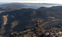
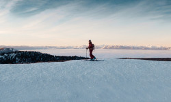
SaveReno (otherwise known as the Biggest Little City in the World) is home to several beautiful and amazing mountain biking trails. Situated right next to Tahoe and the Sierra Nevadas, this city offers and variety of trails from jumps on a former golf course to just plain old speed riding down the Peavine Mountain. This city is sure to offer you some good-natured fun This area is e-bike friendly, but please be careful and acknowledge the places in which e-bikes are not allowed.
Activities Click to view
- Mountain Bike
302 trails
- E-Bike
288 trails
- Gravel Bike
28 trails
- Adaptive Bike
143 trails
- Winter Fat Bike
115 trails
- Horse
22 trails
- Hike
291 trails
- Trail Running
292 trails
- Dirtbike/Moto
20 trails
- ATV/ORV/OHV
4 trails
- Downhill Ski
21 trails
- Nordic Ski
4 trails
Region Details
- 136
- 8
- 44
- 75
- 27
- 12
Region Status
Open as of Jun 9, 2026Stats
- Avg Trail Rating
- Trails (view details)
- 335
- Trails Mountain Bike
- 302
- Trails E-Bike
- 288
- Trails Gravel Bike
- 28
- Trails Adaptive Bike
- 143
- Trails Winter Fat Bike
- 115
- Trails Horse
- 22
- Trails Hike
- 292
- Trails Trail Running
- 292
- Trails Dirtbike/Moto
- 20
- Trails Observed Trials
- 1
- Trails ATV/ORV/OHV
- 4
- Trails Downhill Ski
- 21
- Trails Nordic Ski
- 4
- Total Distance
- 262 miles
- Total Descent
- 46,912 ft
- Total Vertical
- 5,387 ft
- Highest Trailhead
- 9,770 ft
- Reports
- 3,462
- Photos
- 668
- Ridden Counter
- 66,516
Articles
How Reno Tahoe Became an Adventure Capital of the West
Oct 12, 2023 from outsideonline.com
The Biggest Little City has earned major clout as a base camp for outdoor activities, and everyone—from vacationers to adventurers looking to...
Slopes to City: The Best Way to Spend 48 Hours in Reno and Tahoe
Jan 11, 2022 from skimag.com
With plenty of good food and drinks, events, and nightlife, there’s a lot more to Reno-Tahoe than its phenomenal skiing
Sub Regions
-
Ballardini Ranch
- 3
- 2
-
Caughlin Ranch
- 4
- 1
- 6
- 4
- 1
-
North Valleys Regional Park
- 8
-
Peavine Mountain
- 3
- 9
- 22
- 7
- 4
-
Sierra Vista Park
- 1
- 16
- 7
- 2
-
Sky Tavern Bike Park
- 2
- 6
- 5
- 2
-
Thomas Creek/Whites Creek
- 5
- 10
- 3
- 2
-
Verdi
- 3
- 14
- 5
- 1
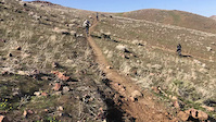
Popular Reno Mountain Biking Trails
• 100 ★ 3.8 • 2 miles • 331 ft • 1,207 •
Popular and fairly simple ride through , up the remains of the primary northern road out of Reno during the late 1800s. Some short rocky sections are challenging to ride for beginners and intermediates, but easy to walk.
• 95 ★ 3.2 • 3 miles • 968 ft • 1,002 •
is a fairly smooth trail with lots of berms and good flow. It's also a pretty gradual climb/descent making it one of the easier routes up Peavine Mt.
• 95 ★ 3.6 • 3,106 ft • 245 ft • 987 •
Popular blue difficulty singletrack. This mountain bike primary trail can be used one direction and has a moderate overall physical rating with a 245 ft blue climb. On average it takes 8 minutes to complete this trail.
• 95 ★ 4.0 • 2 miles • 0 ft • 985 •
Trail from Hoge Rd TH to Bench on Trail. Middle section of trail has been rerouted spring 2025. New reroute makes trail more continuous grade with a few features. Trail has been enhanced and improved spring of 2020. Top portion of trail...
• 95 ★ 2.8 • 2,675 ft • 5 ft • 962 •
Connector trail, not really its own thing. Couple fun bits near the top off the aqueduct though.
• 90 ★ 3.8 • 2 miles • 231 ft • 929 •
Popular blue difficulty singletrack. This mountain bike primary trail can be used one direction and has a moderate overall physical rating with a 231 ft blue climb. On average it takes 15 minutes to complete this trail.
• 100 ★ 3.0 • 1,644 ft • 104 ft • 918 •
A few marginal rock jumps in the downhill direction, and some dusty lumps in the uphill direction.
Reno Mountain Bike Routes
★ 4.5 • 6 miles • 1,100 ft • 4 • Loop •
A regular loop in the Reno area with a fun descent on the North side. Keep speed low and manageable to...
★ 5.0 • 12 miles • 1,971 ft • 6 • Loop •
Great tour of some peavine hits. , and fisticuffs
★ 5.0 • 2 miles • 228 ft • 3 •
An easy trail that takes you from the top of the park to the bottom. There aren't too many features on the...
★ 3.7 • 6 miles • 862 ft • 4 • Loop •
A quick loop from the Trailhead that highlights a fun and flowy trail, Colpo Canyon. 1. Start at the radio...
★ 5.0 • 5,020 ft • 100 ft • 2 •
A nice little loop around the Sierra Vista Bike Park
★ 4.0 • 18 miles • 2,597 ft • 13 • Loop •
Buttery XC climbs and traverse with some fast descents. Several technical features on the UNR descent with...
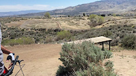
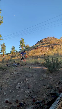
Photos of Reno Mountain Bike
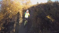
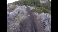
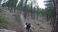
Videos of Reno Mountain Bike
trail: Galena Creek
0:29 |
29 |
Jul 29, 2025

trail: Rick Sutherland
0:55 |
|
Jul 19, 2023
trail: Lower "N" Trail
0:19 |
100 |
Apr 21, 2023
0:22 |
415 |
Apr 23, 2021

0:49 |
564 |
Sep 21, 2020
trail: Lower Alum Creek Trail
0:24 |
227 |
Jul 1, 2020
trail: Whites Creek Trail
0:37 |
419 |
Mar 22, 2018
trail: Brown's Creek
0:54 |
483 |
Aug 12, 2017
Current Trail Warnings
| status | trail | date | condition | user | info |
|---|---|---|---|---|---|
| Top of Sky Access Road | May 30, 2026 @ 6:03am (America/Los_Angeles) May 30, 2026 | Unknown | trailforks Trailforks | ||
| Skyline | May 30, 2026 @ 6:03am (America/Los_Angeles) May 30, 2026 | Unknown | trailforks Trailforks | ||
| Sky Tavern Road | May 30, 2026 @ 6:03am (America/Los_Angeles) May 30, 2026 | Unknown | trailforks Trailforks |
Recent Trail Reports
| status | trail | date | condition | info | user |
|---|---|---|---|---|---|
| Melton School Access Trail | Jun 9, 2026 @ 5:52pm (America/Boise) Jun 9, 2026 | Ideal | Cmoberg | ||
| Lower Keystone Canyon | Jun 9, 2026 @ 5:52pm (America/Boise) Jun 9, 2026 | Ideal | Cmoberg | ||
| Snow Terrace | Jun 9, 2026 @ 5:52pm (America/Boise) Jun 9, 2026 | Ideal | Cmoberg | ||
| B-Lite | Jun 9, 2026 @ 5:52pm (America/Boise) Jun 9, 2026 | Ideal | Cmoberg | ||
| Las Brisas Trail Access from Sage Bluff Ct | Jun 9, 2026 @ 5:52pm (America/Boise) Jun 9, 2026 | Ideal | Cmoberg | ||
| Another Bike Trail | May 31, 2026 @ 9:18pm (America/Los_Angeles) May 31, 2026 | Dry | Belltron42 | ||
| Sierra Front Trail Belli | May 30, 2026 @ 6:41pm (America/Los_Angeles) May 30, 2026 | Ideal | flameffects | ||
| Toaster Boy | May 30, 2026 @ 6:03am (America/Los_Angeles) May 30, 2026 | Unknown | trailforks Trailforks | ||
| Sky Ridge Access Road (East) | May 30, 2026 @ 6:03am (America/Los_Angeles) May 30, 2026 | Unknown | trailforks Trailforks | ||
| Shark Bait | May 30, 2026 @ 6:03am (America/Los_Angeles) May 30, 2026 | Unknown | trailforks Trailforks |
Activity Feed
| username | action | type | title | date |
|---|---|---|---|---|
| Homicycle666 | ridden | trail | activity #97120231 | Jun 16, 2026 @ 10:14am 1 day |
| nemtb42 | wishlist | route | activity #97018320 | Jun 14, 2026 @ 6:54pm 3 days |
| ghyork12 | ridden | trail | activity #96816895 | Jun 12, 2026 @ 11:11am Jun 12, 2026 |
| uF5U7RXl | wishlist | trail | activity #96714734 | Jun 10, 2026 @ 7:59pm Jun 10, 2026 |
| Cmoberg | add | report | activity #96697450 | Jun 10, 2026 @ 2:52pm Jun 10, 2026 |
Recent Comments
| username | type | title | comment | date |
|---|---|---|---|---|
| trail | The trail has been maintained by BLTS and its... | Apr 6, 2026 @ 5:38pm Apr 6, 2026 | ||
| trail | What a great trail!!! Super fun, well made!! | Mar 22, 2026 @ 3:36pm Mar 22, 2026 | ||
| trail | 95% dry with a little mud and smaller snow... | Feb 4, 2026 @ 3:58pm Feb 4, 2026 | ||
| trail | 90% dry with a few small muddy patches and... | Feb 4, 2026 @ 3:57pm Feb 4, 2026 | ||
| trail | Is this open yet? | Jan 31, 2026 @ 5:51pm Jan 31, 2026 |
Local Badges
-

Completionist0 awarded -

Big Ride 30k6,557 awarded -

Epic Ride 50k2,029 awarded -

Top 10 Trails13 awarded -
Completionist0 awarded -
Completionist1 awarded
Bike & Skill Parks
| name | type | city | rating |
|---|---|---|---|
| Sky Tavern Bike Park | bike park | Reno | |
| Sky Tavern Pump Track | skill park | Reno | |
| Sky Tavern Slim Gym | skill park | Reno | |
| Sky Tavern Progression Skills Zone | skill park | Reno |
Local Trail Supporters
![]()
- Sierra Trail Works
- Another Bike Shop
- High Fives Foundation
Activity Type Stats
| activitytype | trails | distance | descent | descent distance | total vertical | rating | global rank | state rank | photos | reports | routes | ridelogs |
|---|---|---|---|---|---|---|---|---|---|---|---|---|
| Mountain Bike | 302 | 246 miles | 43,327 ft | 104 miles | 4,403 ft | #169 | #65 | 728 | 3,462 | 56 | 68,667 | |
| E-Bike | 288 | 230 miles | 39,580 ft | 96 miles | 4,403 ft | #185 | #663 | 17 | 3,261 | 9 | 5,385 | |
| Gravel Bike | 28 | 50 miles | 2,733 ft | 10 miles | 3,622 ft | #84 | #810 | 2 | 239 | 2 | 886 | |
| Adaptive Bike | 143 | 86 miles | 7,690 ft | 27 miles | 3,865 ft | #22 | #1,258 | 679 | 2 | |||
| Winter Fat Bike | 115 | 39 miles | 3,438 ft | 15 miles | 1,841 ft | #19 | #821 | 673 | ||||
| Horse | 22 | 44 miles | 7,940 ft | 19 miles | 3,957 ft | #733 | #557 | 693 | 1 | 3 | ||
| Hike | 291 | 251 miles | 41,539 ft | 101 miles | 5,387 ft | #220 | #113 | 13 | 3,386 | 19 | 4,417 | |
| Trail Running | 292 | 251 miles | 41,539 ft | 101 miles | 5,387 ft | #311 | #125 | 8 | 3,386 | 19 | 8,238 | |
| Dirtbike/Moto | 20 | 39 miles | 11,112 ft | 18 miles | 3,812 ft | #236 | #126 | 690 | 1 | 114 | ||
| Observed Trials | 1 | 5,203 ft | 469 ft | 6 | 6 | |||||||
| ATV/ORV/OHV | 4 | 11 miles | 289 ft | 2 miles | 3,694 ft | #253 | #83 | 675 | 1 | 15 | ||
| Downhill Ski | 21 | 4 miles | 2,762 ft | 3 miles | 646 ft | #317 | #126 | 78 | ||||
| Nordic Ski | 4 | 4,101 ft | 82 ft | 1,604 ft | 584 ft | #482 | #144 | 69 | 64 |
Frequently Asked Questions About Reno
▼
What are the best places to ride in Reno?
Reno has 9 areas to explore for mountain biking. The top rated areas are:
▼
What are the highest rated mountain biking trails in Reno?
The highest rated mountain biking trails in Reno are:
- Lower Intermediate Flow Line Trail (4.5/5)
- Rick Sutherland (4.4/5)
- Intermediate Flow Trail (4.4/5)
- Galena Creek (4.4/5)
- Snake Run (4.4/5)
▼
What is the best time of the year to ride in Reno?
Based on ride log data, the most popular months to ride in Reno are:
- July (818 activities)
- May (687 activities)
- June (664 activities)
▼
Where can I park to ride in Reno?
There are 27 parking locations listed in Reno. The most popular parking spots are:
- Sky Tavern Parking
- East Keystone Parking
- Hoge Road Parking
- Cow Canyon Parking
- Kings Row USFS Parking Lot
Activities
Trails
- By TheAngryTomato
 TRAILFORKS & contributors
 - Admins: BLTS, TAMBA
- #6633 - 70,760 views
- reno activity log | embed map of Reno mountain bike trails | reno mountain biking points of interest
Downloading of trail gps tracks in kml & gpx formats is enabled for Reno.
You must login to download files.