close
-
Layers w
- Weather Layers
- Pro
- Pro
- Pro
- Pro
- Pro
- Pro
- More Layers
- Pro
- Pro
- Pro
- Pro
-
Upgrade to

3D
Trail Conditions
- Unknown
- Snow Groomed
- Snow Packed
- Snow Covered
- Snow Cover Partial
- Freeze/thaw Cycle
- Icy
- Prevalent Mud
- Wet
- Variable
- Ideal
- Dry
- Very Dry
Trail Flow (Ridden Direction)
Trailforks scans users ridelogs to determine the most popular direction each trail is ridden. A good flowing trail network will have most trails flowing in a single direction according to their intension.
The colour categories are based on what percentage of riders are riding a trail in its intended direction.
The colour categories are based on what percentage of riders are riding a trail in its intended direction.
- > 96%
- > 90%
- > 80%
- > 70%
- > 50%
- < 50%
- bi-directional trail
- no data
Trail Last Ridden
Trailforks scans ridelogs to determine the last time a trail was ridden.
- < 2 days
- < 1 week
- < 2 weeks
- < 1 month
- < 6 months
- > 6 months
Trail Ridden Direction
The intended direction a trail should be ridden.
- Downhill Only
- Downhill Primary
- Both Directions
- Uphill Primary
- Uphill Only
- One Direction
Contribute Details
Colors indicate trail is missing specified detail.
- Description
- Photos
- Description & Photos
- Videos
Trail Popularity ?
Trailforks scans ridelogs to determine which trails are ridden the most in the last 9 months.
Trails are compared with nearby trails in the same city region with a possible 25 colour shades.
Think of this as a heatmap, more rides = more kinetic energy = warmer colors.
- most popular
- popular
- less popular
- not popular
ATV/ORV/OHV Filter
Max Vehicle Width
inches
US Cell Coverage
Legend

Radar Time
Activity Recordings
Trailforks uses anonymized public activity data.
?
Activity Recordings
Trailforks uses anonymized public activity data.
?
Personal Heatmap
▶
Activity Types
all
/
none
▶
Options
2
Date range
month
–
Winter Trails
Warning
A routing network for winter maps does not exist. Selecting trails using the winter trails layer has been disabled.
Missing Trails
Most Popular
Least Popular
Trails are colored based on popularity. The more popular a trail is, the more red. Less popular trails trend towards green.
Jump Magnitude Heatmap
Heatmap of where riders jump on trails. Zoom in to see individual jumps, click circles to view jump details.
BC Backroad Status
![map legend]()
Service Road Atlas is a free to use, community-driven service for viewing and creating reports on the numerous back-country service roads around B.C. and Alberta.

Slope Aspect
Direction the slope faces
Trails Deemphasized
Trails are shown in grey.
Only show trails with no bike usage.
Suggested Layers
Based on selected activity type
Save the current map location and zoom level as your default home location whenever this page is loaded.
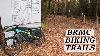
SaveThe Bracebridge Resource Management Centre (BRMC) trails are a mix of double track and single track trails on the edge of the Muskoka River. The single track trails are being developed and maintained by the Muskoka Off Road Cycling Association (MORCA). These trails include some rocky technical trails with punchy ups and downs and some mellow fun trails that wind through pine forests. The trails near the main parking lot tend to be more mellow and less rocky, while the trails south of the main lot highlight the amazing exposed Canadian shield. Please note that wearing a helmet while riding is mandatory.
South lot address (911 number) in case of emergency: 591 Holiday Park Dr
North lot address (911 number) in case of emergency: 5140 Highway 11
There are honour boxes at both the main and south parking lots to help support volunteer efforts to build and maintain the trails. There are several spots to stop and enjoy the view along the Muskoka River. There are outhouses located at the main parking lot and at the Pavilion. There are several benches located along the trails for a break after a long climb.
E-bikes must meet federal rules of 500 watts output @ 32 km maximum. Units exceeding this or modified are not authorized. All e-bikes must have 1 million liability in force while using club trails.
***WINTER NOTE: Please be respectful and avoid Fat Biking and Hiking on Double track trails as it will damage the grooming that is done for Cross country Skiing. ***
Primary Trail Type: Cross-Country
Land Status: Crown Land
Land Manager: Ontario MNRF
 google parking directions
Links
Files
- BRMC-map2025Print.pdf (932 KB)
- BMRC(winter_2025)Final.v1.pdf (1.31 MB)
Region Supporters & Maintainers
![Bracebridge Machine]()
Bracebridge MachineSponsor![Bubbler Buddy]()
Bubbler BuddySponsor![Cavalcade Ford]()
Cavalcade FordSponsor![Climb Muskoka]()
Climb MuskokaSponsor![Daleman & Westcott]()
Daleman & WestcottSponsor![]()
Ecclestone CycleSponsor![Fresh Kutz]()
Fresh KutzSponsor![Kelly Project Management]()
Kelly Project ManagementSponsor![Kona Bikess]()
Kona BikessSponsor![Lake of Bays Brewery]()
Lake of Bays BrewerySponsor![Leon's]()
Leon'sSponsor![Mica Sports/Scott Sports]()
Mica Sports/Scott SportsSponsor![Rally Beer]()
Rally BeerSponsor![Sawdust City Brewery]()
Sawdust City BrewerySponsor![Superfly Racing]()
Superfly RacingSponsor![Virtual Tour Visions]()
Virtual Tour VisionsSponsor![]()
Muskoka Bicycle Pro ShopSponsor![Muskoka Tourism]()
Muskoka TourismSponsor![Delancy Sports Club]()
Delancy Sports ClubSponsor![Crank and Sprocket]()
Crank and SprocketSponsor![Port Carling Dental]()
Port Carling DentalSponsor- The Earth OdysseySponsor
![Muskoka Beer Spa]()
Muskoka Beer SpaSponsor![Steven's Your Independent Grocer]()
Steven's Your Independent GrocerSponsor
Activities Click to view
- Mountain Bike
42 trails
- E-Bike
34 trails
- Hike
44 trails
- Trail Running
42 trails
- Snowshoe
32 trails
- Backcountry Ski
4 trails
- Nordic Ski
16 trails
Region Details
- 5
- 25
- 2
- 7
- 3
Region Status
Caution as of May 22, 2026Stats
- Avg Trail Rating
- Trails (view details)
- 42
- Trails Mountain Bike
- 45
- Trails E-Bike
- 34
- Trails Winter Fat Bike
- 1
- Trails Hike
- 44
- Trails Trail Running
- 42
- Trails Snowshoe
- 32
- Trails Backcountry Ski
- 4
- Trails Nordic Ski
- 16
- Total Distance
- 15 miles
- Total Descent Distance
- 6 miles
- Total Descent
- 1,483 ft
- Total Vertical
- 177 ft
- Highest Trailhead
- 1,057 ft
- Reports
- 3,433
- Photos
- 150
- Ridden Counter
- 13,943
Popular Resource Management Centre Trails
• 100 ★ 4.6 • 2,359 ft • 6 ft • 576 •
One of the more flowy trails in BRMC. This blue trail is most fun if ridden in a northerly direction. It starts with a quick little decent after squeezing through a couple of pine trees and continues towards some whoops and roots. There...
• 100 ★ 4.6 • 2,477 ft • 44 ft • 535 •
Winter's Coming is a classic BRMC trail. Starts with a rocky consistent climbing section and finishes with a longer rocky downhill. Halfway through the trail at the peak, you can split off into which is an easier downhill option.
• 80 ★ 3.0 • 4,833 ft • 63 ft • 530 •
When ridden from the , is a gradual climb up towards some of the more challenging trails at the BRMC. Be aware of the wet sections that are prevalent in the early spring. This is a double track trail. This is a groomed (track set)...
• 100 ★ 3.6 • 640 ft • 0 ft • 488 •
is another fun green trail that is easily accessible from the parking lot. It is a good connector from the parking lot or from to . There are a number of rooty turns and a squeeze between two large pines to keep you on your toes.
• 95 ★ 4.0 • 4,656 ft • 143 ft • 460 •
Wide open single track with mild ups and downs winding through the mixed forest next to a granite rock ridge.
• 90 ★ 4.3 • 2,575 ft • 24 ft • 450 •
Splintting off of , is a technical blue trail with a lot of exposed granite. It is advisable to start this trail from and ride it to the Pavillion. This trail holds moisture more than average and work has been done to help it drain and...
• 95 ★ 5.0 • 4,104 ft • 37 ft • 422 •
The rational yin to the yang of . This trail continues along the exposed Canadian Shield that looms over highway 11. There are several rock rollers, a tough climb (in either direction) and lots of quick punchy moves up onto the exposed...
Mountain Bike Routes
6 miles • 554 ft • 11 •
Optional Add-ons: - add on when near - add on - its too fun not to... - once done , add on a , loop
7 miles • 552 ft • 11 • Loop •
Starting from the South Lot, this intermediate route lets you ride the diverse terrain at the BRMC. You...
6 miles • 567 ft • 14 •
In the intermediate, there is a little bit of everything! Some green, some rocky and flowy blue, a sample...
3 miles • 156 ft • 11 • Loop •
Great initial loop for some green trails and all single track! This route starts with a warm-up on and ....
3 miles • 144 ft • 9 •
Start and end at the pavillion! Follow the route to enjoy the BRMC's northern green single track. If you...
3 miles • 107 ft • 8 •
The proposed route for the "easy" group ride. Pine Peddler is ridden in both directions.
Photos of Resource Management Centre Mountain Bike
Videos of Resource Management Centre Mountain Bike
trail: Winter's Coming
0:34 |
17 |
Jun 10, 2026 , Bracebridge
19:00 |
203 |
Nov 14, 2023

trail: Jake Brake
3:44 |
407 |
Aug 4, 2021 , Bracebridge

trail: Gnarnia
0:01 |
324 |
Jul 14, 2021 , Bracebridge

trail: Rational Goat
0:01 |
519 |
Jul 14, 2021 , Bracebridge

trail: Area 51
16:39 |
380 |
Jul 7, 2021 , Bracebridge

16:39 |
234 |
Jul 7, 2021

trail: Area 51
8:47 |
408 |
Jun 29, 2021 , Bracebridge
Recent Trail Reports
| status | trail | date | condition | info | user |
|---|---|---|---|---|---|
| Jake Brake | May 22, 2026 @ 7:06pm (America/Toronto) May 22, 2026 | Dry | EmilyAo83oL | ||
| Triple Crown | May 18, 2026 @ 8:00am (America/Toronto) May 18, 2026 | Ideal | carpediem1 | ||
| Lower Baby Goat | May 18, 2026 @ 8:00am (America/Toronto) May 18, 2026 | Ideal | carpediem1 | ||
| Upper Baby Goat | May 18, 2026 @ 8:00am (America/Toronto) May 18, 2026 | Ideal | carpediem1 | ||
| Slimer | May 18, 2026 @ 8:00am (America/Toronto) May 18, 2026 | Ideal | carpediem1 | ||
| Pinevillion | May 18, 2026 @ 8:00am (America/Toronto) May 18, 2026 | Ideal | carpediem1 | ||
| Pine Pedaller | May 18, 2026 @ 8:00am (America/Toronto) May 18, 2026 | Ideal | carpediem1 | ||
| Dark Green | May 18, 2026 @ 8:00am (America/Toronto) May 18, 2026 | Ideal | carpediem1 | ||
| Dark Green | May 18, 2026 @ 8:00am (America/Toronto) May 18, 2026 | Ideal | carpediem1 | ||
| Winter's Coming | May 18, 2026 @ 8:00am (America/Toronto) May 18, 2026 | Ideal | carpediem1 |
Activity Feed
| username | action | type | title | date |
|---|---|---|---|---|
| B-rad191919 | ridden | trail | activity #98116920 | Jun 30, 2026 @ 3:03am 57 mins |
| Canadmos | add | video | activity #96680060 | Jun 10, 2026 @ 9:55am Jun 10, 2026 |
| Verris1 | vote | trail | activity #96674562 and 15 more | Jun 10, 2026 @ 8:23am Jun 10, 2026 |
| lpl5iA | wishlist | region | activity #96403228 | Jun 6, 2026 @ 1:43pm Jun 6, 2026 |
| sospeedy | ridden | trail | activity #96192396 | Jun 3, 2026 @ 5:18pm Jun 3, 2026 |
Recent Comments
| username | type | title | comment | date |
|---|---|---|---|---|
| trail | Looked, rolled up, decided to wait for a less... | Jul 13, 2025 @ 6:07pm Jul 13, 2025 | ||
| report | Zs B dad * s; D did YG CC S x Z’ ... | Jul 13, 2025 @ 11:14am Jul 13, 2025 | ||
| report | M | Jul 11, 2025 @ 8:16am Jul 11, 2025 | ||
| trail | Curly is the best of the three, and probably... | Aug 14, 2024 @ 7:35am Aug 14, 2024 | ||
| trail | Correction to description… Curly is the... | Aug 10, 2024 @ 6:33am Aug 10, 2024 |
Nearby Areas
| name | distance | ||||
|---|---|---|---|---|---|
| Bonnie Lake | 1 | 2.7 km | |||
| Wilson's Falls | 5 | 3 | 3.4 km | ||
| Upjohn Nature Reserve | 3 | 3.7 km | |||
| South Monck | 27 | 12 | 1 | 4.2 km | |
| Riverside Bike Park | 4 | 6 | 5.5 km |
Local Badges
-

Completionist1 awarded
Activity Type Stats
| activitytype | trails | distance | descent | descent distance | total vertical | rating | global rank | state rank | photos | reports | routes | ridelogs |
|---|---|---|---|---|---|---|---|---|---|---|---|---|
| Mountain Bike | 42 | 15 miles | 1,483 ft | 6 miles | 177 ft | #1,123 | #33 | 145 | 3,402 | 8 | 5,421 | |
| E-Bike | 34 | 14 miles | 1,371 ft | 6 miles | 177 ft | #4,537 | #101 | 3,376 | 1 | 156 | ||
| Winter Fat Bike | 1 | #1,173 | #39 | 7 | 25 | 3 | 7 | |||||
| Hike | 44 | 15 miles | 1,473 ft | 6 miles | 177 ft | #7,053 | #138 | 2 | 3,400 | 363 | ||
| Trail Running | 42 | 15 miles | 1,247 ft | 6 miles | 177 ft | #6,767 | #91 | 3,398 | 228 | |||
| Snowshoe | 32 | 9 miles | 1,033 ft | 3 miles | 174 ft | #384 | #29 | 2,820 | 2 | 90 | ||
| Backcountry Ski | 4 | 3,533 ft | 89 ft | 1,722 ft | 56 ft | #315 | #3 | 123 | 15 | |||
| Nordic Ski | 16 | 6 miles | 614 ft | 3 miles | 154 ft | #751 | #50 | 2,775 | 196 |
Frequently Asked Questions About Resource Management Centre
▼
What are the highest rated mountain biking trails in Resource Management Centre?
The highest rated mountain biking trails in Resource Management Centre are:
- Crazy Goat (4.5/5)
- Dark Green (4.4/5)
- Dark Green (4.4/5)
- Three Stooges - Curly (4.4/5)
- Rational Goat (4.4/5)
▼
What is the best time of the year to ride in Resource Management Centre?
Based on ride log data, the most popular months to ride in Resource Management Centre are:
- July (156 activities)
- August (98 activities)
- September (75 activities)
▼
Where can I park to ride in Resource Management Centre?
There are 2 parking locations listed in Resource Management Centre. The most popular parking spots are:
▼
What is the longest trail in Resource Management Centre?
The longest trail in Resource Management Centre is Trail 2C at 1.0 mile. View all trails sorted by distance.
Activities
Trails
- Hard trails in Resource Management Centre
- Easy trails in Resource Management Centre
- Favorite trails in Resource Management Centre
- Most ridden trails in Resource Management Centre
- Singletrack in Resource Management Centre
- Viewpoint trails in Resource Management Centre
- Trails with technical features in Resource Management Centre
- Race routes in Resource Management Centre
- By markholloway
 Trailforks Map Team & contributors
 - Admins: MORCA, MORRA, HMBA
- #9865 - 23,389 views
- resource management centre activity log | embed map of Resource Management Centre mountain bike trails | resource management centre mountain biking points of interest polygons
Downloading of trail gps tracks in kml & gpx formats is enabled for Resource Management Centre.
You must login to download files.