close
-
Layers w
- Weather Layers
- Pro
- Pro
- Pro
- Pro
- Pro
- Pro
- More Layers
- Pro
- Pro
- Pro
- Pro
-
Upgrade to

3D
Trail Conditions
- Unknown
- Snow Groomed
- Snow Packed
- Snow Covered
- Snow Cover Partial
- Freeze/thaw Cycle
- Icy
- Prevalent Mud
- Wet
- Variable
- Ideal
- Dry
- Very Dry
Trail Flow (Ridden Direction)
Trailforks scans users ridelogs to determine the most popular direction each trail is ridden. A good flowing trail network will have most trails flowing in a single direction according to their intension.
The colour categories are based on what percentage of riders are riding a trail in its intended direction.
The colour categories are based on what percentage of riders are riding a trail in its intended direction.
- > 96%
- > 90%
- > 80%
- > 70%
- > 50%
- < 50%
- bi-directional trail
- no data
Trail Last Ridden
Trailforks scans ridelogs to determine the last time a trail was ridden.
- < 2 days
- < 1 week
- < 2 weeks
- < 1 month
- < 6 months
- > 6 months
Trail Ridden Direction
The intended direction a trail should be ridden.
- Downhill Only
- Downhill Primary
- Both Directions
- Uphill Primary
- Uphill Only
- One Direction
Contribute Details
Colors indicate trail is missing specified detail.
- Description
- Photos
- Description & Photos
- Videos
Trail Popularity ?
Trailforks scans ridelogs to determine which trails are ridden the most in the last 9 months.
Trails are compared with nearby trails in the same city region with a possible 25 colour shades.
Think of this as a heatmap, more rides = more kinetic energy = warmer colors.
- most popular
- popular
- less popular
- not popular
ATV/ORV/OHV Filter
Max Vehicle Width
inches
US Cell Coverage
Legend

Radar Time
Activity Recordings
Trailforks uses anonymized public activity data.
?
Activity Recordings
Trailforks uses anonymized public activity data.
?
Personal Heatmap
▶
Activity Types
all
/
none
▶
Options
2
Date range
month
–
Winter Trails
Warning
A routing network for winter maps does not exist. Selecting trails using the winter trails layer has been disabled.
Missing Trails
Most Popular
Least Popular
Trails are colored based on popularity. The more popular a trail is, the more red. Less popular trails trend towards green.
Jump Magnitude Heatmap
Heatmap of where riders jump on trails. Zoom in to see individual jumps, click circles to view jump details.
BC Backroad Status
![map legend]()
Service Road Atlas is a free to use, community-driven service for viewing and creating reports on the numerous back-country service roads around B.C. and Alberta.

Slope Aspect
Direction the slope faces
Trails Deemphasized
Trails are shown in grey.
Only show trails with no bike usage.
Suggested Layers
Based on selected activity type
Save the current map location and zoom level as your default home location whenever this page is loaded.
SaveBike Park Closed for Season. Opens on July 11
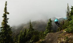
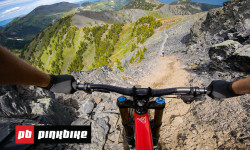
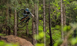
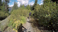
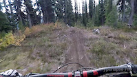
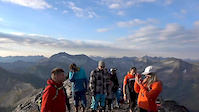
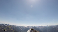
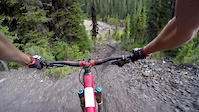
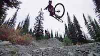
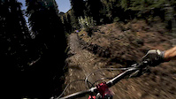
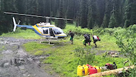
Retallack is a world leader in heli-biking and professionally guided backcountry mountain biking. Their exclusive commercial network of downhill, all-mountain / enduro, and freeride trails is dispersed in the Selkirk and Purcell Mountains of the West Kootenays. Government authorization to expand tenure to create the world’s largest heli-biking and backcountry mountain biking operating area – over 1.5 millions acres. Presently, Retallack is continuing to develop a plethora of trails that will enable customers to access additional descents of up to 6,000 vertical feet via a combination of helicopters, off-road shuttle vans, and boats.
Prices range from $378 to $539 per day.
Prices range from $378 to $539 per day.
Primary Trail Type: All-Mountain & Downhill
Shuttleable: YES
Links
Activities Click to view
- Mountain Bike
14 trails
- Hike
0 trails
- Trail Running
0 trails
Bike Park Details
- 3
- 10
- 1
Region Status
Open as of Aug 22, 2025- Uplift Type
- Shuttle
- Season start
- Jul 11
- Season end
- Oct 10
Stats
- Avg Trail Rating
- Global Ranking
- #4,383
- State Ranking
- #186
- Trails (view details)
- 14
- Trails Mountain Bike
- 14
- Total Distance
- 12 miles
- Total Descent
- 10,446 ft
- Total Vertical
- 4,842 ft
- Highest Trailhead
- 8,217 ft
- Reports
- 10
- Photos
- 98
- Ridden Counter
- 1,646
Articles
Video: Retallack Dream Lines in 'Back to Basics' with Micayla Gatto
Jul 9, 2020 from pinkbike.com
Micayla Gatto gets back to her roots.
First Impressions: One Insane Lap Down Retallack with Casey Brown, Ryan Howard, & Thomas Vanderham
Sep 23, 2019 from pinkbike.com
Earlier this summer, about half of the Pinkbike office made the pilgrimage to the famed Retallack Lodge along with some rad friends.
Video: Vink, Neethling, KJ & More Shred Chatel, Retallack & Nelson
Jun 28, 2019 from pinkbike.com
A full feature from Shaperideshoot shot around the globe.
Photos of Retallack Mountain Bike
Videos of Retallack Mountain Bike
0:55 |
78 |
May 10, 2018
0:42 |
81 |
Apr 11, 2018
2:57 |
81 |
Apr 11, 2018
0:53 |
237 |
Nov 16, 2017
0:32 |
68 |
Sep 20, 2017
2:29 |
37606 |
Nov 1, 2016
2:01 |
7669 |
Jun 9, 2016
4:16 |
172 |
Dec 8, 2015
Recent Trail Reports
| status | trail | date | condition | info | user |
|---|---|---|---|---|---|
| Lower Kessel | Aug 22, 2025 @ 12:44pm Aug 22, 2025 | Ideal | Coachp | ||
| Jump Line | Sep 8, 2023 @ 2:40am Sep 8, 2023 | Ideal | bperkins | ||
| Connector | Sep 8, 2023 @ 2:40am Sep 8, 2023 | Ideal | bperkins | ||
| No Brakes | Sep 8, 2023 @ 2:40am Sep 8, 2023 | Ideal | bperkins | ||
| Swayze | Sep 8, 2023 @ 2:40am Sep 8, 2023 | Ideal | bperkins | ||
| Unknown | Jul 19, 2020 @ 12:05pm Jul 19, 2020 | Dry | tmowat |
Activity Feed
| username | action | type | title | date |
|---|---|---|---|---|
| dalbaz | wishlist | region | activity #95756013 | May 28, 2026 @ 9:28pm May 28, 2026 |
| Pat7FVJez | wishlist | region | activity #95542483 | May 25, 2026 @ 9:16pm May 25, 2026 |
| jamiewallace81 | add | video | activity #92497507 | Apr 12, 2026 @ 2:00pm Apr 12, 2026 |
| leahB | wishlist | region | activity #91847249 | Apr 3, 2026 @ 1:53pm Apr 3, 2026 |
| Alan-d | wishlist | region | activity #91672692 | Mar 31, 2026 @ 3:22pm Mar 31, 2026 |
Recent Comments
| username | type | title | comment | date |
|---|---|---|---|---|
| report | Ugh | Sep 3, 2024 @ 7:17am Sep 3, 2024 |
Nearby Areas
| name | distance | ||||
|---|---|---|---|---|---|
| Idaho Peak | 6 | 4 | 2 | 6.1 km | |
| Dennis Creek Basin Recreation Site | 1 | 8.5 km | |||
| Kaslo Interpretive Forest Recreation Area | 2 | 4 | 1 | 1 | 10.2 km |
| Mount Buchanan (East) | 1 | 2 | 2 | 11.5 km | |
| Rosebery | 3 | 7 | 1 | 11.6 km |
Frequently Asked Questions About Retallack
▼
What is the best time of the year to ride in Retallack?
Based on ride log data, the most popular months to ride in Retallack are:
- September (16 activities)
- August (16 activities)
- July (14 activities)
▼
Where can I park to ride in Retallack?
Check the Retallack trail map for trailhead and parking information. Community members regularly update access and parking details for trails in the area.
▼
How many trails are in Retallack?
Retallack has a total of 14 trails. Browse top mountain biking trails in Retallack to find detailed information including difficulty ratings, distances, and trail conditions.
▼
What activities are most popular in Retallack?
Retallack supports the following activities: Mountain Biking, Hiking, Trail Running.
- By canadaka
 Trailforks & contributors
 - Admins: BCBR, TrailsBC, BCORMA, DSBC, wheelmaniac3, bcpunk, NSTS
- #6021 - 17,602 views
- retallack activity log | embed map of Retallack mountain bike trails |
Downloading of trail gps tracks in kml & gpx formats is disabled for Retallack.