close
-
Layers w
- Weather Layers
- Pro
- Pro
- Pro
- Pro
- Pro
- Pro
- More Layers
- Pro
- Pro
- Pro
- Pro
-
Upgrade to

3D
Trail Conditions
- Unknown
- Snow Groomed
- Snow Packed
- Snow Covered
- Snow Cover Partial
- Freeze/thaw Cycle
- Icy
- Prevalent Mud
- Wet
- Variable
- Ideal
- Dry
- Very Dry
Trail Flow (Ridden Direction)
Trailforks scans users ridelogs to determine the most popular direction each trail is ridden. A good flowing trail network will have most trails flowing in a single direction according to their intension.
The colour categories are based on what percentage of riders are riding a trail in its intended direction.
The colour categories are based on what percentage of riders are riding a trail in its intended direction.
- > 96%
- > 90%
- > 80%
- > 70%
- > 50%
- < 50%
- bi-directional trail
- no data
Trail Last Ridden
Trailforks scans ridelogs to determine the last time a trail was ridden.
- < 2 days
- < 1 week
- < 2 weeks
- < 1 month
- < 6 months
- > 6 months
Trail Ridden Direction
The intended direction a trail should be ridden.
- Downhill Only
- Downhill Primary
- Both Directions
- Uphill Primary
- Uphill Only
- One Direction
Contribute Details
Colors indicate trail is missing specified detail.
- Description
- Photos
- Description & Photos
- Videos
Trail Popularity ?
Trailforks scans ridelogs to determine which trails are ridden the most in the last 9 months.
Trails are compared with nearby trails in the same city region with a possible 25 colour shades.
Think of this as a heatmap, more rides = more kinetic energy = warmer colors.
- most popular
- popular
- less popular
- not popular
ATV/ORV/OHV Filter
Max Vehicle Width
inches
US Cell Coverage
Legend

Radar Time
Activity Recordings
Trailforks uses anonymized public activity data.
?
Activity Recordings
Trailforks uses anonymized public activity data.
?
Personal Heatmap
▶
Activity Types
all
/
none
▶
Options
2
Date range
month
–
Winter Trails
Warning
A routing network for winter maps does not exist. Selecting trails using the winter trails layer has been disabled.
Missing Trails
Most Popular
Least Popular
Trails are colored based on popularity. The more popular a trail is, the more red. Less popular trails trend towards green.
Jump Magnitude Heatmap
Heatmap of where riders jump on trails. Zoom in to see individual jumps, click circles to view jump details.
BC Backroad Status
![map legend]()
Service Road Atlas is a free to use, community-driven service for viewing and creating reports on the numerous back-country service roads around B.C. and Alberta.

Slope Aspect
Direction the slope faces
Trails Deemphasized
Trails are shown in grey.
Only show trails with no bike usage.
Suggested Layers
Based on selected activity type
Save the current map location and zoom level as your default home location whenever this page is loaded.
Save
No description for Rialto has been added yet!
Login or register to submit one.
 google parking directions
Primary Trail Type: All-Mountain & Downhill
Shuttleable: YES
AKA: Robson
google parking directions Activities Click to view
- Mountain Bike
22 trails
- E-Bike
19 trails
- Hike
20 trails
- Trail Running
19 trails
- Dirtbike/Moto
4 trails
- ATV/ORV/OHV
4 trails
Region Details
- 8
- 6
- 3
- 1
Region Status
Caution as of May 29, 2026Stats
- Avg Trail Rating
- Trails (view details)
- 18
- Trails Mountain Bike
- 23
- Trails E-Bike
- 19
- Trails Hike
- 20
- Trails Trail Running
- 19
- Trails Dirtbike/Moto
- 4
- Trails ATV/ORV/OHV
- 4
- Trails Snowmobile
- 3
- Trails Snowshoe
- 2
- Total Distance
- 25 miles
- Total Descent
- 6,280 ft
- Total Vertical
- 3,487 ft
- Highest Trailhead
- 4,961 ft
- Reports
- 238
- Photos
- 177
- Ridden Counter
- 4,447
Popular Rialto Mountain Biking Trails
• 85 ★ 4.5 • 3 miles • 15 ft • 703 •
Highly rated popular black diamond difficulty singletrack. This mountain bike primary trail can be used downhill only and has a moderate overall physical rating. It features a-frame, bridge, drop, jump, gap jump, log ride, rock face, rock garden, roller coaster and skinny. Trail visibility is always easy to follow. On average it takes 39 minutes to complete this trail.
• 95 ★ 4.1 • 2,927 ft • 6 ft • 651 •
Short and sweet flowy downhill. The trail consists of sweet single track, swooping corners and several side jump options. It is sandy and steep in some areas. Some more technical rocky sections at the very end.
• 90 ★ 4.0 • 4,928 ft • 31 ft • 438 •
this is now the lower , we lost access to the previous lower trail.
• 95 ★ 4.6 • 1 mile • 546 ft • 326 •
Multi directional trail built to access down hill trails in area
• 70 ★ 4.7 • 3 miles • 54 ft • 301 •
This trail is a must ride if you are in the area. It has a mix of old and new woodwork, most of which is still intact. Sections from top to bottom include: 40 foot starting skinny, bomber straightaways, a set of jumps going from 5-35...
• 90 ★ 4.8 • 5 miles • 2,941 ft • 285 •
This is a multidirectional trail used to access the down trail in the area. great early season riding, hiking and trail running.
• 95 ★ 5.0 • 1,549 ft • 18 ft • 124 •
A fun and flowing intermediate trail with some optional jumps that connects the climb trail to the descend trail and avoids the Rialto Road.
Rialto Mountain Bike Routes
★ 5.0 • 14 miles • 3,923 ft • 6 • Race •
9 miles • 2,275 ft • 4 • Race •
• 15 miles • 4,386 ft • 10 •
• 18 miles • 4,265 ft • 6 •
• 16 miles • 2,933 ft • 7 •
• 9 miles • 2,389 ft • 7 •
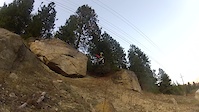
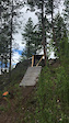
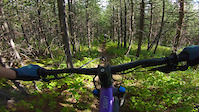
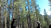
Photos of Rialto Mountain Bike
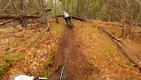
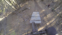
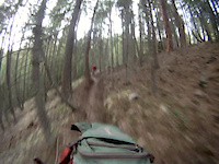
Videos of Rialto Mountain Bike
trail: Dirty Dreams
0:10 |
324 |
Mar 26, 2021
trail: Grandiflorum
0:08 |
177 |
Feb 11, 2021
trail: Grandiflorum
2:04 |
161 |
Jan 28, 2021
trail: The Awakener
2:24 |
543 |
Apr 8, 2019
trail: Dirty Dreams
0:39 |
401 |
Mar 22, 2017

trail: The Awakener
3:14 |
829 |
Jul 28, 2016
trail: The Awakener
0:29 |
697 |
Apr 8, 2016
trail: The Awakener
3:06 |
498 |
May 17, 2014
Recent Trail Reports
| status | trail | date | condition | info | user |
|---|---|---|---|---|---|
| The Awakener | May 29, 2026 @ 3:58pm (America/Vancouver) May 29, 2026 | Unknown | Cgalligos | ||
| Dirty Dreams Climb Trail | May 29, 2026 @ 3:57pm (America/Vancouver) May 29, 2026 | Unknown | Cgalligos | ||
| parking lot connector | May 15, 2026 @ 2:40pm (America/Vancouver) May 15, 2026 | Ideal | Bricklin69 | ||
| Dirty Dreams | May 15, 2026 @ 2:40pm (America/Vancouver) May 15, 2026 | Ideal | Bricklin69 | ||
| Grand Connector | May 15, 2026 @ 2:40pm (America/Vancouver) May 15, 2026 | Ideal | Bricklin69 | ||
| Grandiflorum | May 15, 2026 @ 2:40pm (America/Vancouver) May 15, 2026 | Ideal | Bricklin69 | ||
| Grand 10KM ENTRANCE | May 15, 2026 @ 2:40pm (America/Vancouver) May 15, 2026 | Ideal | Bricklin69 | ||
| Grand Climb | May 15, 2026 @ 2:40pm (America/Vancouver) May 15, 2026 | Ideal | Bricklin69 | ||
| Grandwazoo | Aug 21, 2025 @ 11:14am Aug 21, 2025 | Ideal | Belasoff38 | ||
| Powerline Road | Jul 21, 2024 @ 1:45am Jul 21, 2024 | Very Dry | Jochen54 |
Activity Feed
| username | action | type | title | date |
|---|---|---|---|---|
| gdunn01 | wishlist | trail | activity #97930537 | Jun 27, 2026 @ 12:58pm 2 days |
| Priebec | wishlist | region | activity #97924133 | Jun 27, 2026 @ 11:45am 2 days |
| andrecormier31 | wishlist | trail | activity #97633750 | Jun 23, 2026 @ 9:43am Jun 23, 2026 |
| rocdoc | ridden | trail | activity #97625569 | Jun 23, 2026 @ 7:28am Jun 23, 2026 |
| PatiwDv5P | wishlist | trail | activity #97560962 | Jun 22, 2026 @ 7:39am Jun 22, 2026 |
Recent Comments
| username | type | title | comment | date |
|---|---|---|---|---|
| trail | This is not enywhere close to be blue trail,... | Jul 31, 2025 @ 4:45pm Jul 31, 2025 | ||
| trail | Amazing trail. Much respect to the trail... | Jul 2, 2025 @ 4:21pm Jul 2, 2025 | ||
| trail | Beautiful climb. Props to the builders! | May 24, 2025 @ 2:10pm May 24, 2025 | ||
| trail | Absolutely beautiful climb. There’s a wooden... | May 24, 2025 @ 2:09pm May 24, 2025 | ||
| trail | Climb is in good shape as far as the 110... | Apr 19, 2025 @ 10:58am Apr 19, 2025 |
Nearby Areas
| name | distance | ||||
|---|---|---|---|---|---|
| Goose Creek | 5.3 km | ||||
| Millennium Park | 1 | 5.5 km | |||
| Merry Creek | 1 | 3 | 5 | 1 | 5.7 km |
| Selkirk College | 11 | 7 | 6.3 km | ||
| Syringa Provincial Park | 4 | 3 | 6.7 km |
Activity Type Stats
| activitytype | trails | distance | descent | descent distance | total vertical | rating | global rank | state rank | photos | reports | routes | ridelogs |
|---|---|---|---|---|---|---|---|---|---|---|---|---|
| Mountain Bike | 22 | 25 miles | 6,280 ft | 9 miles | 3,488 ft | #3,206 | #151 | 176 | 238 | 2 | 3,205 | |
| E-Bike | 19 | 24 miles | 5,922 ft | 9 miles | 3,488 ft | #3,986 | #145 | 205 | 183 | |||
| Hike | 20 | 16 miles | 6,102 ft | 9 miles | 3,451 ft | #7,890 | #312 | 1 | 231 | 91 | ||
| Trail Running | 19 | 16 miles | 6,099 ft | 9 miles | 3,451 ft | #7,415 | #277 | 231 | 17 | |||
| Dirtbike/Moto | 4 | 10 miles | 177 ft | 3,491 ft | 3,448 ft | #677 | #62 | 23 | 8 | |||
| ATV/ORV/OHV | 4 | 10 miles | 177 ft | 3,491 ft | 3,448 ft | #465 | #43 | 23 | 1 | |||
| Snowmobile | 3 | 9 miles | 3 ft | 456 ft | 3,448 ft | 3 | ||||||
| Snowshoe | 2 | 2 miles | 39 ft | 814 ft | 860 ft | 1 |
Frequently Asked Questions About Rialto
▼
What are the highest rated mountain biking trails in Rialto?
The highest rated mountain biking trails in Rialto are:
- The Awakener (4.5/5)
- Grand Climb (4.5/5)
- Grandiflorum (4.4/5)
- Dirty Dreams Climb Trail (4.3/5)
- Grandwazoo (4.1/5)
▼
What is the best time of the year to ride in Rialto?
Based on ride log data, the most popular months to ride in Rialto are:
- July (43 activities)
- April (25 activities)
- May (22 activities)
▼
Where can I park to ride in Rialto?
There are 2 parking locations listed in Rialto. The most popular parking spots are:
▼
What is the longest trail in Rialto?
The longest trail in Rialto is Grand Climb at 5.5 miles. View all trails sorted by distance.
Activities
- By barry-mclane & contributors
- Admins: CPTS, sawalaskwa, KCTS
- #5795 - 12,943 views
- rialto activity log | embed map of Rialto mountain bike trails | rialto mountain biking points of interest
Downloading of trail gps tracks in kml & gpx formats is enabled for Rialto.
You must login to download files.