close
-
Layers w
- Weather Layers
- Pro
- Pro
- Pro
- Pro
- Pro
- Pro
- More Layers
- Pro
- Pro
- Pro
- Pro
-
Upgrade to

3D
Trail Conditions
- Unknown
- Snow Groomed
- Snow Packed
- Snow Covered
- Snow Cover Partial
- Freeze/thaw Cycle
- Icy
- Prevalent Mud
- Wet
- Variable
- Ideal
- Dry
- Very Dry
Trail Flow (Ridden Direction)
Trailforks scans users ridelogs to determine the most popular direction each trail is ridden. A good flowing trail network will have most trails flowing in a single direction according to their intension.
The colour categories are based on what percentage of riders are riding a trail in its intended direction.
The colour categories are based on what percentage of riders are riding a trail in its intended direction.
- > 96%
- > 90%
- > 80%
- > 70%
- > 50%
- < 50%
- bi-directional trail
- no data
Trail Last Ridden
Trailforks scans ridelogs to determine the last time a trail was ridden.
- < 2 days
- < 1 week
- < 2 weeks
- < 1 month
- < 6 months
- > 6 months
Trail Ridden Direction
The intended direction a trail should be ridden.
- Downhill Only
- Downhill Primary
- Both Directions
- Uphill Primary
- Uphill Only
- One Direction
Contribute Details
Colors indicate trail is missing specified detail.
- Description
- Photos
- Description & Photos
- Videos
Trail Popularity ?
Trailforks scans ridelogs to determine which trails are ridden the most in the last 9 months.
Trails are compared with nearby trails in the same city region with a possible 25 colour shades.
Think of this as a heatmap, more rides = more kinetic energy = warmer colors.
- most popular
- popular
- less popular
- not popular
ATV/ORV/OHV Filter
Max Vehicle Width
inches
US Cell Coverage
Legend

Radar Time
Activity Recordings
Trailforks uses anonymized public activity data.
?
Activity Recordings
Trailforks uses anonymized public activity data.
?
Personal Heatmap
▶
Activity Types
all
/
none
▶
Options
2
Date range
month
–
Winter Trails
Warning
A routing network for winter maps does not exist. Selecting trails using the winter trails layer has been disabled.
Missing Trails
Most Popular
Least Popular
Trails are colored based on popularity. The more popular a trail is, the more red. Less popular trails trend towards green.
Jump Magnitude Heatmap
Heatmap of where riders jump on trails. Zoom in to see individual jumps, click circles to view jump details.
BC Backroad Status
![map legend]()
Service Road Atlas is a free to use, community-driven service for viewing and creating reports on the numerous back-country service roads around B.C. and Alberta.

Slope Aspect
Direction the slope faces
Trails Deemphasized
Trails are shown in grey.
Only show trails with no bike usage.
Suggested Layers
Based on selected activity type
Save the current map location and zoom level as your default home location whenever this page is loaded.
Save
No description for Richfield has been added yet!
Login or register to submit one.
Activities Click to view
- Mountain Bike
66 trails
- E-Bike
28 trails
- Gravel Bike
0 trails
- Adaptive Bike
0 trails
- Winter Fat Bike
0 trails
- Horse
27 trails
- Hike
57 trails
- Trail Running
54 trails
- Dirtbike/Moto
15 trails
- ATV/ORV/OHV
20 trails
- Snowmobile
5 trails
Region Details
- 13
- 3
- 8
- 24
- 15
- 1
Region Status
Caution as of 45 minsStats
- Avg Trail Rating
- Trails (view details)
- 73
- Trails Mountain Bike
- 66
- Trails E-Bike
- 28
- Trails Horse
- 27
- Trails Hike
- 57
- Trails Trail Running
- 54
- Trails Dirtbike/Moto
- 15
- Trails ATV/ORV/OHV
- 20
- Trails Snowmobile
- 5
- Total Distance
- 175 miles
- Total Descent
- 31,540 ft
- Total Vertical
- 6,195 ft
- Highest Trailhead
- 11,538 ft
- Reports
- 850
- Photos
- 438
- Ridden Counter
- 26,425
Sub Regions
-
Fremont Indian State Park
- 1
- 5
- 2
-
Pahvant Trail System
- 1
- 5
- 9
- 6
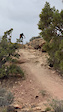
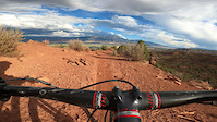
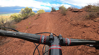
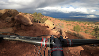
Popular Richfield Mountain Biking Trails
• 100 ★ 4.8 • 4 miles • 59 ft • 2,166 •
Downhill only trail that runs down ridges, rock spines, and slick rock with flow sections, technical descents, drops, berms, and amazing views. This trail is not for beginner or intermediate riders and has no nearby access so be...
• 100 ★ 4.3 • 5 miles • 254 ft • 1,822 •
Middle is a 5-mile extension of the Lower . The trail starts with gentle slow rolling slopes with awesome views for about a mile. The trail then gets rowdy with steep descents, large banked turns, and plenty of jumps followed by a 1/4...
• 100 ★ 4.2 • 1,322 ft • 5 ft • 1,725 •
Fast and flowy singletrack trail that connects to Cairnage. Trail includes several rock rollers, drops, and berms. This is part of the Pahvant Trail System
• 95 ★ 4.7 • 2 miles • 44 ft • 1,484 •
This trail gets its namesake from the old poles and wire that you will see scattered along portions of this trail. The trail begins with a short easy climb to get to the top of the ridge and then its all downhill from there. The trail...
• 95 ★ 4.8 • 2 miles • 56 ft • 1,468 •
Single track trail that follows through natural and man-made "cairn" rock features. Lots of drops, jumps, rock gardens, and flow sections. This trail is downhill only and is a great intermediate trail.
• 90 ★ 4.2 • 2 miles • 126 ft • 1,442 •
is an extension of the existing trail. The trail crosses a large fault line and provides access to the DH, One In a Pinion, and Spinal Tap Trails.
• 90 ★ 4.6 • 4 miles • 879 ft • 1,405 •
Bi-directional trail that is part of thePahvant MTB trail system. Trail follows gentle climbing slopes with generous berms on turns, slick rock sections, and amazing scenery. The higher up you go the more technical challenges you will...
• 90 ★ 4.1 • 2 miles • 28 ft • 1,378 •
This is the latest extension of the trail that traverses the huge fault line and connects the and trails. This is an easy climbing trail that leads you to amazing views of the cottonwood canyon below. Its worth stopping at the ridge...
Richfield Mountain Bike Routes
★ 4.7 • 19 miles • 504 ft • 3 • Shuttled •
The full route, top to bottom. Typically you shuttle to the top, then make the drop. Dirt roads to the top...
★ 5.0 • 13 miles • 1,840 ft • 14 • Loop •
Loop ride to get to while taking single track trails.
★ 5.0 • 15 miles • 2,283 ft • 23 • Loop •
Two loops in order to hit Juniper Drop, and Cairn-age. Hits most of the trails other than Spinal Tap.
★ 3.0 • 12 miles • 1,676 ft • 5 •
For the more adventurous take this route to the top to enjoy the full downhill experience. The trail is...
★ 5.0 • 29 miles • 4,264 ft • 16 •
Hit all best trails in one epic ride
★ 1.0 • 8 miles • 1,027 ft • 3 •
This is a great loop if you want to go a little longer than the shorter loop. The hi-line segment is worth...
Photos of Richfield Mountain Bike
Videos of Richfield Mountain Bike
trail: Lower Spinal Tap
0:07 |
33 |
May 24, 2026
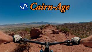
trail: Cairn-Age
0:33 |
194 |
Aug 6, 2022
trail: Kiln-It
0:12 |
151 |
Aug 6, 2022
trail: Kiln-It
0:14 |
83 |
Aug 6, 2022

trail: Lower Spinal Tap
27:03 |
106 |
Mar 28, 2026 , Richfield

trail: Middle Spinal Tap
27:03 |
109 |
Mar 28, 2026 , Richfield

trail: Upper Spinal Tap
27:03 |
85 |
Mar 28, 2026 , Richfield
Current Trail Warnings
| status | trail | date | condition | user | info |
|---|---|---|---|---|---|
| Fishlake Overlook | Jun 21, 2026 @ 11:47am (America/Denver) 45 mins | Unknown | scottmorris | Still *so* many downed trees, on the... |
Recent Trail Reports
| status | trail | date | condition | info | user |
|---|---|---|---|---|---|
| Kiln-It | May 23, 2026 @ 9:33pm (America/Denver) May 23, 2026 | Ideal | Sdhmccullough | ||
| Lower Spinal Tap | May 16, 2026 @ 11:57am (America/Phoenix) May 16, 2026 | Very Dry | iBam | ||
| Middle Spinal Tap | May 16, 2026 @ 11:57am (America/Phoenix) May 16, 2026 | Very Dry | iBam | ||
| Upper Spinal Tap | May 16, 2026 @ 11:57am (America/Phoenix) May 16, 2026 | Very Dry | iBam | ||
| Cairn-Age | May 9, 2026 @ 9:25am (America/Phoenix) May 9, 2026 | Ideal | Otisredwood | ||
| Big Red | May 9, 2026 @ 9:25am (America/Phoenix) May 9, 2026 | Ideal | Otisredwood | ||
| Tank Run | May 9, 2026 @ 9:25am (America/Phoenix) May 9, 2026 | Ideal | Otisredwood | ||
| Lower Faulty | May 2, 2026 @ 11:50am (America/Phoenix) May 2, 2026 | Dry | PapaChip WTF | ||
| Dos Equis | Apr 4, 2026 @ 1:35pm (America/Phoenix) Apr 4, 2026 | Dry | rhowe96 | ||
| Telegraph Connector | Apr 4, 2026 @ 1:35pm (America/Phoenix) Apr 4, 2026 | Ideal | rhowe96 |
National Scenic Trails & Official Routes
-
Great Western Trail
- Mountain Bike
- E-Bike
- Horse
- Hike
- Trail Running
- Dirtbike/Moto
- ATV/ORV/OHV

Activity Feed
| username | action | type | title | date |
|---|---|---|---|---|
| scottmorris | add | report | activity #97501259 | Jun 21, 2026 @ 10:50am 41 mins |
| RyanS13 | ridden | trail | activity #97446044 and 1 more | Jun 20, 2026 @ 5:46pm 18 hours |
| Linzar | wishlist | route | activity #97355900 | Jun 19, 2026 @ 5:27pm 2 days |
| IVQ51Oh1 | ridden | trail | activity #97269582 and 6 more | Jun 18, 2026 @ 12:26pm 3 days |
| Junnyhda | wishlist | route | activity #97214853 | Jun 17, 2026 @ 4:05pm Jun 17, 2026 |
Recent Comments
| username | type | title | comment | date |
|---|---|---|---|---|
| report | We s | Jun 13, 2026 @ 11:01am Jun 13, 2026 | ||
| report | And a | Jun 11, 2026 @ 4:47pm Jun 11, 2026 | ||
| trail | An absolute masterpiece of trail. | Jun 4, 2026 @ 9:51pm Jun 4, 2026 | ||
| trail | On May 28 2026, saw a rattlesnake laying... | May 28, 2026 @ 11:09am May 28, 2026 | ||
| report | Ehe b | May 23, 2026 @ 9:05am May 23, 2026 |
Local Badges
-

Epic Ride Climb 2k28 awarded -

Climbing 10k Badge31 awarded -

Climbing 100k Badge4 awarded -

Epic Ride Descent 2k67 awarded -

Descent 10k Badge74 awarded -

Descent 100k Badge4 awarded
Bike & Skill Parks
| name | type | city | rating |
|---|---|---|---|
| Red Hills BMX | skill park | Richfield | |
| Richfield Pump Track | skill park | Richfield |
Activity Type Stats
| activitytype | trails | distance | descent | descent distance | total vertical | rating | global rank | state rank | photos | reports | routes | ridelogs |
|---|---|---|---|---|---|---|---|---|---|---|---|---|
| Mountain Bike | 66 | 167 miles | 29,045 ft | 76 miles | 6,194 ft | #732 | #284 | 429 | 850 | 16 | 15,546 | |
| E-Bike | 28 | 92 miles | 12,740 ft | 35 miles | 5,453 ft | #1,504 | #870 | 540 | 1 | 1,275 | ||
| Horse | 27 | 76 miles | 14,728 ft | 34 miles | 5,837 ft | #568 | #518 | 41 | 3 | |||
| Hike | 57 | 135 miles | 21,555 ft | 57 miles | 6,194 ft | #1,525 | #685 | 9 | 738 | 367 | ||
| Trail Running | 54 | 136 miles | 21,545 ft | 57 miles | 6,194 ft | #459 | #179 | 739 | 1 | 199 | ||
| Dirtbike/Moto | 15 | 54 miles | 10,545 ft | 24 miles | 5,381 ft | #418 | #155 | 42 | 10 | |||
| ATV/ORV/OHV | 20 | 67 miles | 11,289 ft | 27 miles | 5,381 ft | #155 | #67 | 1 | 42 | 7 | ||
| Snowmobile | 5 | 18 miles | 1,447 ft | 5 miles | 2,060 ft | #76 | #47 |
Frequently Asked Questions About Richfield
▼
What are the best places to ride in Richfield?
Richfield has 2 areas to explore for mountain biking. The top rated areas are:
▼
What are the highest rated mountain biking trails in Richfield?
The highest rated mountain biking trails in Richfield are:
- Lower Spinal Tap (4.7/5)
- Cairn-Age (4.7/5)
- Telegraph (4.6/5)
- Juniper Drop (4.5/5)
- Kiln-It (4.5/5)
▼
What is the best time of the year to ride in Richfield?
Based on ride log data, the most popular months to ride in Richfield are:
- October (96 activities)
- May (88 activities)
- September (60 activities)
▼
Where can I park to ride in Richfield?
There are 16 parking locations listed in Richfield. The most popular parking spots are:
- South Trailhead Parking
- Pahvant South Trailhead Parking
- Lower Shuttle Parking
- Middle Spinal Tap Parking
- PARKING (Kiln-It)
Activities
Trails
- By Devinway & contributors
- Admins: jkwilliamz, UtahJohn, jpmcghee, jasonmalczyk, RCTC
- #18590 - 66,324 views
- richfield activity log | embed map of Richfield mountain bike trails | richfield mountain biking points of interest
Downloading of trail gps tracks in kml & gpx formats is enabled for Richfield.
You must login to download files.