close
-
Layers w
- Weather Layers
- Pro
- Pro
- Pro
- Pro
- Pro
- Pro
- More Layers
- Pro
- Pro
- Pro
- Pro
-
Upgrade to

3D
Trail Conditions
- Unknown
- Snow Groomed
- Snow Packed
- Snow Covered
- Snow Cover Partial
- Freeze/thaw Cycle
- Icy
- Prevalent Mud
- Wet
- Variable
- Ideal
- Dry
- Very Dry
Trail Flow (Ridden Direction)
Trailforks scans users ridelogs to determine the most popular direction each trail is ridden. A good flowing trail network will have most trails flowing in a single direction according to their intension.
The colour categories are based on what percentage of riders are riding a trail in its intended direction.
The colour categories are based on what percentage of riders are riding a trail in its intended direction.
- > 96%
- > 90%
- > 80%
- > 70%
- > 50%
- < 50%
- bi-directional trail
- no data
Trail Last Ridden
Trailforks scans ridelogs to determine the last time a trail was ridden.
- < 2 days
- < 1 week
- < 2 weeks
- < 1 month
- < 6 months
- > 6 months
Trail Ridden Direction
The intended direction a trail should be ridden.
- Downhill Only
- Downhill Primary
- Both Directions
- Uphill Primary
- Uphill Only
- One Direction
Contribute Details
Colors indicate trail is missing specified detail.
- Description
- Photos
- Description & Photos
- Videos
Trail Popularity ?
Trailforks scans ridelogs to determine which trails are ridden the most in the last 9 months.
Trails are compared with nearby trails in the same city region with a possible 25 colour shades.
Think of this as a heatmap, more rides = more kinetic energy = warmer colors.
- most popular
- popular
- less popular
- not popular
ATV/ORV/OHV Filter
Max Vehicle Width
inches
US Cell Coverage
Legend

Radar Time
Activity Recordings
Trailforks uses anonymized public activity data.
?
Activity Recordings
Trailforks uses anonymized public activity data.
?
Personal Heatmap
▶
Activity Types
all
/
none
▶
Options
2
Date range
month
–
Winter Trails
Warning
A routing network for winter maps does not exist. Selecting trails using the winter trails layer has been disabled.
Missing Trails
Most Popular
Least Popular
Trails are colored based on popularity. The more popular a trail is, the more red. Less popular trails trend towards green.
Jump Magnitude Heatmap
Heatmap of where riders jump on trails. Zoom in to see individual jumps, click circles to view jump details.
BC Backroad Status
![map legend]()
Service Road Atlas is a free to use, community-driven service for viewing and creating reports on the numerous back-country service roads around B.C. and Alberta.

Slope Aspect
Direction the slope faces
Trails Deemphasized
Trails are shown in grey.
Only show trails with no bike usage.
Suggested Layers
Based on selected activity type
Save the current map location and zoom level as your default home location whenever this page is loaded.
Save
No description for Ridgemont has been added yet!
Login or register to submit one.
Activities Click to view
- Mountain Bike
71 trails
- E-Bike
64 trails
- Gravel Bike
5 trails
- Hike
71 trails
- Trail Running
71 trails
- Snowshoe
32 trails
Region Details
- 10
- 11
- 36
- 12
- 2
Region Status
Caution as of 9 hoursStats
- Avg Trail Rating
- Trails (view details)
- 72
- Trails Mountain Bike
- 71
- Trails E-Bike
- 64
- Trails Gravel Bike
- 5
- Trails Hike
- 71
- Trails Trail Running
- 71
- Trails Snowshoe
- 32
- Trails Nordic Ski
- 1
- Total Distance
- 52 miles
- Total Descent
- 13,941 ft
- Total Vertical
- 2,583 ft
- Highest Trailhead
- 5,912 ft
- Reports
- 3,909
- Photos
- 474
- Ridden Counter
- 38,442
Popular Ridgemont Mountain Biking Trails
• 100 ★ 4.4 • 1,886 ft • 151 ft • 2,521 •
An easy switchback climb parallel to Ridgemont Rd up to the Eco Terrorist Boardwalks.
• 100 ★ 3.6 • 2,451 ft • 78 ft • 2,468 •
Fun section of of wooden boardwalks, a few inches off the ground but definitely make you focus on keeping your wheel straight.
• 100 ★ 3.0 • 2,254 ft • 148 ft • 2,431 •
This trail by-passes the cemetery to access Ridgemont via . Easy little section through the tress, over a little wooden bridge and then a bit of grunt up to the water plant.
• 100 ★ 2.2 • 1,532 ft • 23 ft • 2,309 •
Part of the Elk Valley / TransCanada Trail; This can be accessed at either end for a very mellow ride through the forest near Coal Creek Road. Couple of minor climbs but nothing too tough. All the local kids' bike maps use it to...
• 100 ★ 3.5 • 722 ft • 0 ft • 2,300 •
Easier climb - stay right and enjoy a switch back to avoid the first steeper pitch. Re-engineered in Fall 2017 for an even easier, bermier route.
• 100 ★ 4.8 • 1,578 ft • 0 ft • 2,201 •
Fun run down into town, including a crazy over the trail loop.
• 100 ★ 4.6 • 2,274 ft • 189 ft • 2,056 •
The easiest climb up into Ridgemont. Designed to help kids climb into Ridgemont, so don't try and Strava it on the down...
Ridgemont Mountain Bike Routes
★ 3.5 • 5 miles • 865 ft • 9 • Point to Point •
This is our standard ridgemont ride. The decent is a real decent and this would not be suitable for...
★ 4.0 • 6 miles • 1,081 ft • 3 • Loop •
Blue Ride climb up Coal Discovery Trail to TR3 (Blue). Then use KUSH (Dn) which is a moderate Black. Then...
★ 5.0 • 4 miles • 763 ft • 29 •
Great intermediate route, or an early season warm-up. Try Face Shots for something more challenging
★ 4.0 • 22 miles • 4,085 ft • 14 •
FMBC's Low Roller 2018 - do as much or as little as you want!
4 miles • 1,974 ft • 4 • Out & Back •
The Hike This hike starts off pretty mellow and progressively gets steeper. The beauty of it is there are...
★ 5.0 • 2 miles • 510 ft • 18 •
Easiest approach to riding Will take approximately 45 minutes to 1 hour.
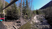
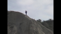
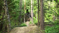
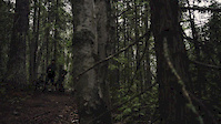
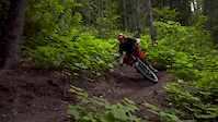
Photos of Ridgemont Mountain Bike
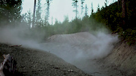
Videos of Ridgemont Mountain Bike
0:25 |
12 |
Apr 27, 2026
trail: Brads Trail
0:56 |
100 |
Aug 14, 2024
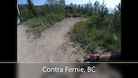
trail: Contra
4:03 |
130 |
Jul 17, 2021

trail: Contra
0:42 |
454 |
May 8, 2019
trail: Contra
3:45 |
8128 |
Aug 9, 2018
trail: Brads Trail
0:27 |
782 |
Aug 7, 2018
trail: Ridgemont Road
2:42 |
8895 |
Jun 30, 2018
trail: Brads Trail
0:02 |
9697 |
May 20, 2017
Current Trail Warnings
| status | trail | date | condition | user | info |
|---|---|---|---|---|---|
| Eco-Terrorist | Jun 12, 2026 @ 11:06am (America/Creston) Jun 12, 2026 | Wet | scottg FTA |
Recent Trail Reports
| status | trail | date | condition | info | user |
|---|---|---|---|---|---|
| Contra | Jun 17, 2026 @ 12:12pm (America/Edmonton) 9 hours | Unknown | Benwfmartin FTA | ||
| Coal Creek Heritage Trail (East) | Jun 15, 2026 @ 10:59am (America/Edmonton) 2 days | Ideal | FernieBC | ||
| Coal Creek Heritage Trail | Jun 15, 2026 @ 10:59am (America/Edmonton) 2 days | Ideal | FernieBC | ||
| Space Unicorn Up | Jun 13, 2026 @ 10:18am (America/Edmonton) Jun 13, 2026 | Variable | Nutrifit | ||
| Kids Stuff Upper | Jun 14, 2026 @ 7:03am (America/Edmonton) Jun 14, 2026 | Ideal | scottg FTA | ||
| Old Stumpy | Jun 13, 2026 @ 8:34am (America/Creston) Jun 13, 2026 | Ideal | scottg FTA | ||
| Oh Dear | Jun 13, 2026 @ 8:34am (America/Creston) Jun 13, 2026 | Ideal | scottg FTA | ||
| R-Trail | Jun 13, 2026 @ 8:34am (America/Creston) Jun 13, 2026 | Variable | scottg FTA | ||
| Up Dog | Jun 13, 2026 @ 8:34am (America/Creston) Jun 13, 2026 | Ideal | scottg FTA | ||
| Coal Creek Heritage Trail | Jun 13, 2026 @ 8:34am (America/Creston) Jun 13, 2026 | Ideal | scottg FTA |
Activity Feed
| username | action | type | title | date |
|---|---|---|---|---|
| Evalchuis | wishlist | trail | activity #97210665 | Jun 17, 2026 @ 2:49pm 5 hours |
| Benwfmartin | add | report | activity #97197421 | Jun 17, 2026 @ 11:12am 9 hours |
| Lucas0976 | wishlist | trail | activity #97123800 | Jun 16, 2026 @ 10:57am 1 day |
| garrettmeunier1 | wishlist | route | activity #97059920 | Jun 15, 2026 @ 12:40pm 2 days |
| FernieBC | add | report | activity #97049122 and 1 more | Jun 15, 2026 @ 10:00am 2 days |
Recent Comments
| username | type | title | comment | date |
|---|---|---|---|---|
| report | Note- i left one 4” log which is easily... | Apr 26, 2026 @ 5:49pm Apr 26, 2026 | ||
| report | Apologies I should have taken a picture, they... | Apr 22, 2026 @ 6:28am Apr 22, 2026 | ||
| report | How big are the trees? | Apr 21, 2026 @ 5:34pm Apr 21, 2026 | ||
| trail | COW MOOSE up before bench near Ridgemont road,... | Apr 8, 2026 @ 10:40am Apr 8, 2026 | ||
| trail | Back up and fully operational! | Jul 27, 2025 @ 6:01pm Jul 27, 2025 |
Nearby Areas
| name | distance | ||||
|---|---|---|---|---|---|
| Montane Fernie | 8 | 17 | 1 | 1.3 km | |
| Fernie Ridge | 1.5 km | ||||
| Castle Mountain | 1 | 10 | 9 | 1 | 2.1 km |
| Mount Proctor | 4 | 9 | 1 | 2.6 km | |
| Mount Fernie Provincial Park | 24 | 18 | 10 | 2.6 km |
Local Badges
-

Completionist0 awarded
Bike & Skill Parks
| name | type | city | rating |
|---|---|---|---|
| Fernie Dirt Jump Park | skill park | Fernie |
Local Mountain Biking Directory
-
Mystic Mountain Adventures
![Mystic Mountain Adventures]()
-
Tourism Fernie
![Tourism Fernie]()
-
Fernie Trails AllianceTrail Association
![Fernie Trails Alliance]()
-
Fernie Mountain Bike ClubClub
![Fernie Mountain Bike Club]()
-
GearHub SportsBike Shop
![GearHub Sports]()
-
The Guide's HutBike Shop
![The Guide's Hut]()
Activity Type Stats
| activitytype | trails | distance | descent | descent distance | total vertical | rating | global rank | state rank | photos | reports | routes | ridelogs |
|---|---|---|---|---|---|---|---|---|---|---|---|---|
| Mountain Bike | 71 | 52 miles | 13,930 ft | 22 miles | 2,582 ft | #165 | #24 | 469 | 3,906 | 24 | 18,201 | |
| E-Bike | 64 | 49 miles | 12,808 ft | 20 miles | 2,582 ft | #2,026 | #69 | 1 | 4,168 | 2 | 367 | |
| Gravel Bike | 5 | 5 miles | 95 ft | 2,024 ft | 814 ft | #40 | #5 | 193 | 31 | |||
| Hike | 71 | 51 miles | 13,888 ft | 22 miles | 2,582 ft | #3,125 | #142 | 4 | 4,318 | 1 | 460 | |
| Trail Running | 71 | 51 miles | 13,888 ft | 22 miles | 2,582 ft | #1,779 | #53 | 4,318 | 1 | 1,505 | ||
| Snowshoe | 32 | 25 miles | 4,341 ft | 9 miles | 1,070 ft | #303 | #22 | 380 | 41 | |||
| Nordic Ski | 1 | 2 miles | 7 ft | 482 ft | 869 ft | 80 | 127 |
Frequently Asked Questions About Ridgemont
▼
What are the highest rated mountain biking trails in Ridgemont?
The highest rated mountain biking trails in Ridgemont are:
- Broken Hip aka Space Unicorn (4.7/5)
- Big Money (4.6/5)
- Kiddy Up (4.4/5)
- Contra (4.3/5)
- Queen V (4.3/5)
▼
What is the best time of the year to ride in Ridgemont?
Based on ride log data, the most popular months to ride in Ridgemont are:
- July (463 activities)
- August (397 activities)
- June (362 activities)
▼
Where can I park to ride in Ridgemont?
Check the Ridgemont trail map for trailhead and parking information. Community members regularly update access and parking details for trails in the area.
▼
What is the longest trail in Ridgemont?
The longest trail in Ridgemont is Coal Creek Heritage Trail (East) at 8.4 km. View all trails sorted by distance.
Activities
Trails
Points of Interest
- By canadaka
 Trailforks & contributors
 - Admins: FTA, scottg, skibum6969, STMS, RDEK
- #1963 - 30,240 views
- ridgemont activity log | embed map of Ridgemont mountain bike trails | ridgemont mountain biking points of interest polygons
Downloading of trail gps tracks in kml & gpx formats is enabled for Ridgemont.
You must login to download files.