close
-
Layers w
- Weather Layers
- Pro
- Pro
- Pro
- Pro
- Pro
- Pro
- More Layers
- Pro
- Pro
- Pro
- Pro
-
Upgrade to

3D
Trail Conditions
- Unknown
- Snow Groomed
- Snow Packed
- Snow Covered
- Snow Cover Partial
- Freeze/thaw Cycle
- Icy
- Prevalent Mud
- Wet
- Variable
- Ideal
- Dry
- Very Dry
Trail Flow (Ridden Direction)
Trailforks scans users ridelogs to determine the most popular direction each trail is ridden. A good flowing trail network will have most trails flowing in a single direction according to their intension.
The colour categories are based on what percentage of riders are riding a trail in its intended direction.
The colour categories are based on what percentage of riders are riding a trail in its intended direction.
- > 96%
- > 90%
- > 80%
- > 70%
- > 50%
- < 50%
- bi-directional trail
- no data
Trail Last Ridden
Trailforks scans ridelogs to determine the last time a trail was ridden.
- < 2 days
- < 1 week
- < 2 weeks
- < 1 month
- < 6 months
- > 6 months
Trail Ridden Direction
The intended direction a trail should be ridden.
- Downhill Only
- Downhill Primary
- Both Directions
- Uphill Primary
- Uphill Only
- One Direction
Contribute Details
Colors indicate trail is missing specified detail.
- Description
- Photos
- Description & Photos
- Videos
Trail Popularity ?
Trailforks scans ridelogs to determine which trails are ridden the most in the last 9 months.
Trails are compared with nearby trails in the same city region with a possible 25 colour shades.
Think of this as a heatmap, more rides = more kinetic energy = warmer colors.
- most popular
- popular
- less popular
- not popular
ATV/ORV/OHV Filter
Max Vehicle Width
inches
US Cell Coverage
Legend

Radar Time
Activity Recordings
Trailforks uses anonymized public activity data.
?
Activity Recordings
Trailforks uses anonymized public activity data.
?
Personal Heatmap
▶
Activity Types
all
/
none
▶
Options
2
Date range
month
–
Winter Trails
Warning
A routing network for winter maps does not exist. Selecting trails using the winter trails layer has been disabled.
Missing Trails
Most Popular
Least Popular
Trails are colored based on popularity. The more popular a trail is, the more red. Less popular trails trend towards green.
Jump Magnitude Heatmap
Heatmap of where riders jump on trails. Zoom in to see individual jumps, click circles to view jump details.
BC Backroad Status
![map legend]()
Service Road Atlas is a free to use, community-driven service for viewing and creating reports on the numerous back-country service roads around B.C. and Alberta.

Slope Aspect
Direction the slope faces
Trails Deemphasized
Trails are shown in grey.
Only show trails with no bike usage.
Suggested Layers
Based on selected activity type
Save the current map location and zoom level as your default home location whenever this page is loaded.
SaveRiver Bends Park contains 8.5 miles of trails, both dirt two-track, and CRAMBA-maintained single track. An asphalt path runs throughout the park, crossing the Clinton River to Woodall Neighborhood Park, and it will eventually connect to downtown Utica.
Containing a paved path, wide two track, and single track trail, River Bends is a park for everyone. The single track trail winds its way south along beautifully wooded, terraced ridge before turning north and snaking through trees and heavy brush tunnels. The single track trails are beginner friendly but present enough of a challenge that seasoned riders won't be bored.
Containing a paved path, wide two track, and single track trail, River Bends is a park for everyone. The single track trail winds its way south along beautifully wooded, terraced ridge before turning north and snaking through trees and heavy brush tunnels. The single track trails are beginner friendly but present enough of a challenge that seasoned riders won't be bored.
Primary Trail Type: Cross-Country
eBikes Allowed:
No
Land Status: Municipal Park
Land Manager: Shelby Township Parks and Recreation
 google parking directions
 Access Info:
Use entrance off 22 Mile road west of Shelby road. Park in the southeast corner of parking lot. Regular Tuesday Night CRAMBA rides start at 6:30 from the Utica Police Parking Lot off of Auburn Rd accessing the trail from the southern end when trail conditions are favorable.
Files
Activities Click to view
- Mountain Bike
12 trails
- Hike
13 trails
- Trail Running
13 trails
Region Details
- 2
- 1
- 6
- 3
Region Status
Open as of Jun 13, 2026Stats
- Avg Trail Rating
- Trails (view details)
- 12
- Trails Mountain Bike
- 14
- Trails Hike
- 13
- Trails Trail Running
- 13
- Total Distance
- 13 miles
- Total Descent
- 744 ft
- Total Vertical
- 77 ft
- Highest Trailhead
- 702 ft
- Reports
- 1,218
- Photos
- 22
- Ridden Counter
- 6,184
Popular River Bends Park Mountain Biking Trails
• 100 ★ 3.7 • 1 mile • 42 ft • 558 •
Popular blue difficulty singletrack. This mountain bike primary trail can be used both directions. On average it takes 6 minutes to complete this trail.
• 50 ★ 4.4 • 2 miles • 110 ft • 547 •
Highly rated moderately popular blue difficulty family friendly singletrack. This mountain bike primary trail can be used one direction and has a easy overall physical rating with a 110 ft green climb. It features roller coaster. On average it takes 10 minutes to complete this trail.
• 70 ★ 5.0 • 2,270 ft • 10 ft • 539 •
Highly rated popular blue difficulty singletrack. This mountain bike primary trail can be used one direction. On average it takes 2 minutes to complete this trail.
• 55 ★ 5.0 • 1 mile • 10 ft • 530 •
Moderately popular blue difficulty singletrack. This mountain bike primary trail can be used one direction. On average it takes 4 minutes to complete this trail.
• 75 ★ 5.0 • 692 ft • 0 ft • 527 •
Popular blue difficulty singletrack. This mountain bike primary trail can be used one direction. On average it takes minutes to complete this trail.
• 60 ★ 5.0 • 909 ft • 3 ft • 515 •
Moderately popular blue difficulty singletrack. This mountain bike primary trail can be used downhill primary. On average it takes minutes to complete this trail.
• 90 ★ 5.0 • 1,138 ft • 0 ft • 513 •
Popular blue difficulty singletrack. This mountain bike primary trail can be used one direction with a 0 ft blue climb. On average it takes minutes to complete this trail.
• 80 ★ 4.3 • 3 miles • 47 ft • 423 •
Easier 3.0 mile loops located between the railroad tracks and the Historic Clinton-Kalamazoo canal.
River Bends Park Mountain Bike Routes
5 miles • 186 ft • 4 • Loop •
Merging in a single route Yellow and tracks
8 miles • 235 ft • 9 • Loop •
These are beginner friendly XC trails that you can access from the main parking. This route includes all...
456 ft • 7 ft • 0 • Point to Point •
2-way red loop to yellow loop connecter route
Photos of River Bends Park Mountain Bike
Videos of River Bends Park Mountain Bike
youtuber
![What makes older Trails Better?]()

3:15 |
197 |
May 14, 2023
youtuber
![First time on a trail at River Bends Park near...]()
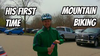
13:31 |
418 |
Jun 21, 2020
youtuber
![Robbins Ridge at River Bends Park with @dukeofmtb]()
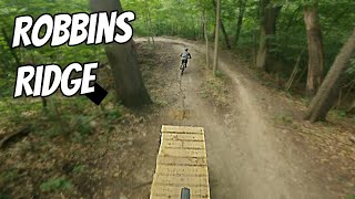
trail: Robbins Ridge - Black
8:24 |
549 |
Apr 26, 2023 , Utica

7:12 |
332 |
Jan 27, 2020 , Utica

trail: Yellow: Ridge Trail
7:12 |
581 |
Jan 27, 2020 , Utica

7:12 |
299 |
Jan 27, 2020

9:29 |
273 |
Jul 23, 2019
20:18 |
458 |
Jul 23, 2019
Recent Trail Reports
Activity Feed
| username | action | type | title | date |
|---|---|---|---|---|
| jer091 | add | report | activity #96895460 and 9 more | Jun 13, 2026 @ 10:46am Jun 13, 2026 |
| Patrick6uzJ8G | wishlist | region | activity #96233342 | Jun 4, 2026 @ 9:23am Jun 4, 2026 |
| Kz44tz | add | report | activity #91610247 and 7 more | Mar 30, 2026 @ 2:59pm Mar 30, 2026 |
| seankkowalski | wishlist | route | activity #90892937 | Mar 19, 2026 @ 5:47pm Mar 19, 2026 |
| seankkowalski | wishlist | route | activity #90490854 | Mar 13, 2026 @ 8:06am Mar 13, 2026 |
Recent Comments
| username | type | title | comment | date |
|---|---|---|---|---|
| trail | Down tree in the back part of the Red... | Oct 18, 2025 @ 12:47pm Oct 18, 2025 | ||
| report | Thanks for the report. Was out there today... | Aug 20, 2022 @ 1:54pm Aug 20, 2022 | ||
| report | Checked with the Utica Mayor and he said the... | Nov 24, 2020 @ 6:45am Nov 24, 2020 | ||
| trail | Enjoyable | Aug 7, 2020 @ 3:41am Aug 7, 2020 | ||
| trail | Great flow, tons of fun | May 2, 2020 @ 5:46pm May 2, 2020 |
Nearby Areas
| name | distance | ||||
|---|---|---|---|---|---|
| Chief Gene Shepherd Park | 11 | 2.3 km | |||
| Bloomer Park | 1 | 3.4 km | |||
| Clinton River Park Trails | 2 | 3 | 4.3 km | ||
| Stony Creek Metropark | 13 | 5 | 6 | 6 km | |
| Wolcott Mill Metropark | 2 | 2 | 10.3 km |
Activity Type Stats
| activitytype | trails | distance | descent | descent distance | total vertical | rating | global rank | state rank | photos | reports | routes | ridelogs |
|---|---|---|---|---|---|---|---|---|---|---|---|---|
| Mountain Bike | 12 | 13 miles | 745 ft | 4 miles | 75 ft | #1,219 | #419 | 24 | 1,234 | 5 | 10,533 | |
| Hike | 13 | 12 miles | 692 ft | 4 miles | 75 ft | #10,200 | #4,007 | 1 | 1,231 | 2 | 287 | |
| Trail Running | 13 | 12 miles | 692 ft | 4 miles | 75 ft | #9,591 | #3,481 | 1,231 | 67 |
Frequently Asked Questions About River Bends Park
▼
What are the highest rated mountain biking trails in River Bends Park?
The highest rated mountain biking trails in River Bends Park are:
- Yellow: Entrance Trail (4.5/5)
- Yellow: Between The Trails (BTT) Trail (4.4/5)
- Yellow: Ridge Trail (4.2/5)
- Ridge Trail Drop (4.2/5)
- Dragstrip (4.1/5)
▼
What is the best time of the year to ride in River Bends Park?
Based on ride log data, the most popular months to ride in River Bends Park are:
- August (143 activities)
- July (139 activities)
- September (109 activities)
▼
Where can I park to ride in River Bends Park?
There are 3 parking locations listed in River Bends Park. The most popular parking spots are: View all parking and trailhead locations on the map to plan your visit.
▼
What is the longest trail in River Bends Park?
The longest trail in River Bends Park is Clinton-Kalamazoo (CK) - Red loop at 2.5 miles. View all trails sorted by distance.
Activities
- By markholloway
 Trailforks Map Team & contributors
 - Admins: CRAMBA, CRAMBA, CRAMBA
- #11282 - 22,097 views
- river bends park activity log | embed map of River Bends Park mountain bike trails | river bends park mountain biking points of interest
Downloading of trail gps tracks in kml & gpx formats is enabled for River Bends Park.
You must login to download files.