close
-
Layers w
- Weather Layers
- Pro
- Pro
- Pro
- Pro
- Pro
- Pro
- More Layers
- Pro
- Pro
- Pro
- Pro
-
Upgrade to

3D
Trail Conditions
- Unknown
- Snow Groomed
- Snow Packed
- Snow Covered
- Snow Cover Partial
- Freeze/thaw Cycle
- Icy
- Prevalent Mud
- Wet
- Variable
- Ideal
- Dry
- Very Dry
Trail Flow (Ridden Direction)
Trailforks scans users ridelogs to determine the most popular direction each trail is ridden. A good flowing trail network will have most trails flowing in a single direction according to their intension.
The colour categories are based on what percentage of riders are riding a trail in its intended direction.
The colour categories are based on what percentage of riders are riding a trail in its intended direction.
- > 96%
- > 90%
- > 80%
- > 70%
- > 50%
- < 50%
- bi-directional trail
- no data
Trail Last Ridden
Trailforks scans ridelogs to determine the last time a trail was ridden.
- < 2 days
- < 1 week
- < 2 weeks
- < 1 month
- < 6 months
- > 6 months
Trail Ridden Direction
The intended direction a trail should be ridden.
- Downhill Only
- Downhill Primary
- Both Directions
- Uphill Primary
- Uphill Only
- One Direction
Contribute Details
Colors indicate trail is missing specified detail.
- Description
- Photos
- Description & Photos
- Videos
Trail Popularity ?
Trailforks scans ridelogs to determine which trails are ridden the most in the last 9 months.
Trails are compared with nearby trails in the same city region with a possible 25 colour shades.
Think of this as a heatmap, more rides = more kinetic energy = warmer colors.
- most popular
- popular
- less popular
- not popular
ATV/ORV/OHV Filter
Max Vehicle Width
inches
US Cell Coverage
Legend

Radar Time
Activity Recordings
Trailforks uses anonymized public activity data.
?
Activity Recordings
Trailforks uses anonymized public activity data.
?
Personal Heatmap
▶
Activity Types
all
/
none
▶
Options
2
Date range
month
–
Winter Trails
Warning
A routing network for winter maps does not exist. Selecting trails using the winter trails layer has been disabled.
Missing Trails
Most Popular
Least Popular
Trails are colored based on popularity. The more popular a trail is, the more red. Less popular trails trend towards green.
Jump Magnitude Heatmap
Heatmap of where riders jump on trails. Zoom in to see individual jumps, click circles to view jump details.
BC Backroad Status
![map legend]()
Service Road Atlas is a free to use, community-driven service for viewing and creating reports on the numerous back-country service roads around B.C. and Alberta.

Slope Aspect
Direction the slope faces
Trails Deemphasized
Trails are shown in grey.
Only show trails with no bike usage.
Suggested Layers
Based on selected activity type
Save the current map location and zoom level as your default home location whenever this page is loaded.
SaveBicycling is not permitted at Rocky Point from November 1 through March 31 due to hunting seasons, or as posted. Trails may also remain closed until as late as April 1, or as posted, due to excessive impacts from the late winter freeze and thaw cycles.
Bicycling is permitted April 1st through April 30th; May 1st through May 31st, after noon only; and June 1st through October 31st, or as otherwise posted.
Rocky Point has a variety of trails from some family friendly areas to more advanced sections. There are lots of intersections between trails and fire roads, so keep an eye out for other users. The trail is well-marked, so watch for signage and you should be fine. There are a variety of wildlife that appear on the trails (deer, turtles, turkeys, pheasant, fox, etc.), so watch for them, too. The trail is closed from November to early April. The is a race on the site each September, so be aware of possible trail closure that weekend. Check for ticks after riding any trail in this area.
Disclaimer:
Bicycling is not permitted at Rocky Point from November 1 through March 31 due to hunting seasons, or as posted. Trails may also remain closed until as late as April 1, or as posted, due to excessive impacts from the late winter freeze and thaw cycles.
Bicycling is permitted April 1st through April 30th; May 1st through May 31st, after noon only; and June 1st through October 31st, or as otherwise posted.
DEC access and parking permits are necessary. https://www.dec.ny.gov/docs/regions_pdf/newaccessprmt.pdf
Bicycling is permitted April 1st through April 30th; May 1st through May 31st, after noon only; and June 1st through October 31st, or as otherwise posted.
DEC access and parking permits are necessary. https://www.dec.ny.gov/docs/regions_pdf/newaccessprmt.pdf
Links
Region Supporters & Maintainers
Activities Click to view
- Mountain Bike
35 trails
- Gravel Bike
0 trails
- Adaptive Bike
0 trails
- Winter Fat Bike
0 trails
- Hike
33 trails
- Trail Running
33 trails
Region Details
- 2
- 1
- 9
- 3
- 17
- 3
Region Status
Closed as of 3 daysStats
- Avg Trail Rating
- Trails (view details)
- 38
- Trails Mountain Bike
- 35
- Trails Hike
- 33
- Trails Trail Running
- 33
- Total Distance
- 46 miles
- Total Descent Distance
- 13 miles
- Total Descent
- 1,104 ft
- Total Vertical
- 135 ft
- Highest Trailhead
- 204 ft
- Reports
- 1,141
- Photos
- 131
- Ridden Counter
- 9,605
Sub Regions
-
Rocky Point Conservation Area
- 1
- 8
- 3
- 17
- 3
Popular Rocky Point Mountain Biking Trails
• 95 ★ 4.4 • 1,293 ft • 0 ft • 520 •
A fun little excursion. No major challenges or threats.
• 90 ★ 4.8 • 4,491 ft • 38 ft • 513 •
is a series of moguls, climbs, and descents. The tread early in the loop can be a bit sketchy, with roots, but it smooths out and becomes a hard, fast treat. There is a telephone pole feature at one point (watch your chainring).
• 90 ★ 4.5 • 1,211 ft • 2 ft • 507 •
Popular blue difficulty singletrack. This mountain bike primary trail can be used one direction. On average it takes 1 minutes to complete this trail.
• 55 ★ 4.0 • 1,250 ft • 25 ft • 466 •
Trail starts of in a descent with lots of roots where people lose their water bottles. Once at the bottom there’s a right turn into a sandy section before starting back a root filled climb. Because of the sand pit it’s tricky to...
Rocky Point Mountain Bike Routes
Rocky Point Main Blue Loop Featured
★ 3.7 • 11 miles • 193 ft • 2 • Loop •
This is the CLIMB beginner ride route main look blue only. No optional sections are included.
Rocky Point Complete Featured
★ 5.0 • 20 miles • 648 ft • 22 • Loop •
This route includes all trails at Rocky Point Conservation Area.
Rocky Point Blue Only Featured
★ 5.0 • 15 miles • 326 ft • 2 • Loop •
This route includes only blue trails at Rocky Point Conservation Area.
★ 5.0 • 16 miles • 517 ft • 16 • Loop • Race •
This route is a 17-mile loop used by the RP50 race. The full 50 mile race will use loop the route three...
• 21 miles • 618 ft • 19 •
• 17 miles • 326 ft • 7 •
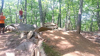
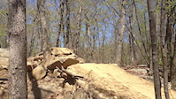
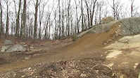
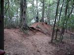
Photos of Rocky Point Mountain Bike
Current Trail Warnings
| status | trail | date | condition | user | info |
|---|---|---|---|---|---|
| Half Pipe | Jun 15, 2026 @ 8:01am (America/New_York) 3 days | Variable | krka73 | Large tree down about 3/4's of the way... | |
| Rock N Roll | Jun 15, 2026 @ 7:59am (America/New_York) 3 days | Variable | krka73 | Large tree down about midway through,... | |
| Campsite | Jun 15, 2026 @ 7:55am (America/New_York) 3 days | Variable | krka73 | Large tree down between the entrance... |
Recent Trail Reports
| status | trail | date | condition | info | user |
|---|---|---|---|---|---|
| Big Birch | Jun 15, 2026 @ 8:04am (America/New_York) 3 days | Variable | krka73 | ||
| Whiskey Rd Connector | Jun 4, 2026 @ 10:02pm (America/New_York) Jun 4, 2026 | Unknown | sick4surf CLIMB | ||
| Main Loop | May 27, 2026 @ 6:32pm (America/New_York) May 27, 2026 | Unknown | Polecatwillie | ||
| Mogul Three | May 26, 2026 @ 4:38pm (America/New_York) May 26, 2026 | Ideal | Polecatwillie | ||
| Pine Loop | May 19, 2026 @ 6:34pm (America/New_York) May 19, 2026 | Ideal | Polecatwillie | ||
| Westside Side Bail-Out | Mar 31, 2026 @ 9:31pm (America/New_York) Mar 31, 2026 | Variable | MTBMarcin CLIMB | ||
| West Side Mogul Two | Mar 31, 2026 @ 9:31pm (America/New_York) Mar 31, 2026 | Variable | MTBMarcin CLIMB | ||
| West Side Mogul One | Mar 31, 2026 @ 9:31pm (America/New_York) Mar 31, 2026 | Variable | MTBMarcin CLIMB | ||
| West Side Loop | Mar 31, 2026 @ 9:31pm (America/New_York) Mar 31, 2026 | Variable | MTBMarcin CLIMB | ||
| Waterbottle Hil | Mar 31, 2026 @ 9:31pm (America/New_York) Mar 31, 2026 | Variable | MTBMarcin CLIMB |
Activity Feed
| username | action | type | title | date |
|---|---|---|---|---|
| MTBMarcin | comment | report | activity #97035038 and 1 more | Jun 15, 2026 @ 5:45am 3 days |
| MTBMarcin | like | report | activity #97035030 and 1 more | Jun 15, 2026 @ 5:45am 3 days |
| krka73 | add | report | activity #97033312 and 3 more | Jun 15, 2026 @ 4:58am 3 days |
| MTBMarcin | comment | report | activity #96283288 | Jun 5, 2026 @ 3:03am Jun 5, 2026 |
| MTBMarcin | like | report | activity #96283284 | Jun 5, 2026 @ 3:03am Jun 5, 2026 |
Recent Comments
| username | type | title | comment | date |
|---|---|---|---|---|
| report | Thank you for great details in the report. | Jun 15, 2026 @ 5:46am 3 days | ||
| report | Thank you for reporting. | Jun 15, 2026 @ 5:45am 3 days | ||
| report | Thank you! | Jun 5, 2026 @ 3:03am Jun 5, 2026 | ||
| report | Thank you for reporting and trail work! | May 26, 2026 @ 4:24pm May 26, 2026 | ||
| report | Team work! Thanks! | May 17, 2026 @ 6:48pm May 17, 2026 |
Local Badges
-

Completed Six of Rocky Point Moguls48 awarded -

10 Black Trails294 awarded -

Epic Ride Climb 2k1 awarded -

Climbing 10k Badge11 awarded -

Climbing 100k Badge0 awarded -

Epic Ride Descent 2k1 awarded
Activity Type Stats
| activitytype | trails | distance | descent | descent distance | total vertical | rating | global rank | state rank | photos | reports | routes | ridelogs |
|---|---|---|---|---|---|---|---|---|---|---|---|---|
| Mountain Bike | 35 | 35 miles | 758 ft | 9 miles | 128 ft | #1,879 | #689 | 134 | 1,141 | 4 | 7,665 | |
| Hike | 33 | 39 miles | 991 ft | 10 miles | 135 ft | #5,935 | #2,081 | 3 | 1,128 | 113 | ||
| Trail Running | 33 | 39 miles | 991 ft | 10 miles | 135 ft | #5,363 | #1,688 | 1,128 | 122 |
Frequently Asked Questions About Rocky Point
▼
What are the best places to ride in Rocky Point?
Rocky Point has 1 areas to explore for mountain biking. The top rated areas are:
▼
What are the highest rated mountain biking trails in Rocky Point?
The highest rated mountain biking trails in Rocky Point are:
- Fern Valley (4.4/5)
- Rocky Point Moguls (4.3/5)
- Main Loop (4.3/5)
- Mogul Two (4.2/5)
- Rattle Snake (4.2/5)
▼
What is the best time of the year to ride in Rocky Point?
Based on ride log data, the most popular months to ride in Rocky Point are:
- June (218 activities)
- July (210 activities)
- May (205 activities)
▼
Where can I park to ride in Rocky Point?
There are 7 parking locations listed in Rocky Point. The most popular parking spots are: View all parking and trailhead locations on the map to plan your visit.
Activities
Trails
Points of Interest
- By donkirb
 & contributors
 - Admins: CLIMB
- #6698 - 11,758 views
- rocky point activity log | embed map of Rocky Point mountain bike trails | rocky point mountain biking points of interest
Downloading of trail gps tracks in kml & gpx formats is enabled for Rocky Point.
You must login to download files.