close
-
Layers w
- Weather Layers
- Pro
- Pro
- Pro
- Pro
- Pro
- Pro
- More Layers
- Pro
- Pro
- Pro
- Pro
-
Upgrade to

3D
Trail Conditions
- Unknown
- Snow Groomed
- Snow Packed
- Snow Covered
- Snow Cover Partial
- Freeze/thaw Cycle
- Icy
- Prevalent Mud
- Wet
- Variable
- Ideal
- Dry
- Very Dry
Trail Flow (Ridden Direction)
Trailforks scans users ridelogs to determine the most popular direction each trail is ridden. A good flowing trail network will have most trails flowing in a single direction according to their intension.
The colour categories are based on what percentage of riders are riding a trail in its intended direction.
The colour categories are based on what percentage of riders are riding a trail in its intended direction.
- > 96%
- > 90%
- > 80%
- > 70%
- > 50%
- < 50%
- bi-directional trail
- no data
Trail Last Ridden
Trailforks scans ridelogs to determine the last time a trail was ridden.
- < 2 days
- < 1 week
- < 2 weeks
- < 1 month
- < 6 months
- > 6 months
Trail Ridden Direction
The intended direction a trail should be ridden.
- Downhill Only
- Downhill Primary
- Both Directions
- Uphill Primary
- Uphill Only
- One Direction
Contribute Details
Colors indicate trail is missing specified detail.
- Description
- Photos
- Description & Photos
- Videos
Trail Popularity ?
Trailforks scans ridelogs to determine which trails are ridden the most in the last 9 months.
Trails are compared with nearby trails in the same city region with a possible 25 colour shades.
Think of this as a heatmap, more rides = more kinetic energy = warmer colors.
- most popular
- popular
- less popular
- not popular
ATV/ORV/OHV Filter
Max Vehicle Width
inches
US Cell Coverage
Legend

Radar Time
Activity Recordings
Trailforks uses anonymized public activity data.
?
Activity Recordings
Trailforks uses anonymized public activity data.
?
Personal Heatmap
▶
Activity Types
all
/
none
▶
Options
2
Date range
month
–
Winter Trails
Warning
A routing network for winter maps does not exist. Selecting trails using the winter trails layer has been disabled.
Missing Trails
Most Popular
Least Popular
Trails are colored based on popularity. The more popular a trail is, the more red. Less popular trails trend towards green.
Jump Magnitude Heatmap
Heatmap of where riders jump on trails. Zoom in to see individual jumps, click circles to view jump details.
BC Backroad Status
![map legend]()
Service Road Atlas is a free to use, community-driven service for viewing and creating reports on the numerous back-country service roads around B.C. and Alberta.

Slope Aspect
Direction the slope faces
Trails Deemphasized
Trails are shown in grey.
Only show trails with no bike usage.
Suggested Layers
Based on selected activity type
Save the current map location and zoom level as your default home location whenever this page is loaded.
Save
No description for Rogers has been added yet!
Login or register to submit one.
Activities Click to view
- Mountain Bike
120 trails
- E-Bike
107 trails
- Adaptive Bike
0 trails
- Horse
2 trails
- Hike
123 trails
- Trail Running
123 trails
Region Details
- 67
- 27
- 13
- 9
Region Status
Open as of 1 dayStats
- Avg Trail Rating
- Trails (view details)
- 121
- Trails Mountain Bike
- 120
- Trails E-Bike
- 107
- Trails Horse
- 2
- Trails Hike
- 123
- Trails Trail Running
- 123
- Total Distance
- 99 miles
- Total Descent
- 7,703 ft
- Total Vertical
- 295 ft
- Highest Trailhead
- 1,430 ft
- Reports
- 1,187
- Photos
- 372
- Ridden Counter
- 39,384
Sub Regions
-
Hobbs State Park
- 10
- 4
- 1
-
Lake Atalanta
- 8
- 10
- 9
- 8
Popular Rogers Mountain Biking Trails
• 100 ★ 4.7 • 8 miles • 898 ft • 1,992 •
This trail has it all. Counter-clockwise the trail starts with a short, well-designed climb before miles of rolling ridgeline riding. Once you think you've had enough of that a short downhill takes you to the lake where you are...
• 100 ★ 4.7 • 2 miles • 145 ft • 1,942 •
Easy/Beginners trail going downhill connecting the end of the coming from the Park Visitor Center to the intersection. Flowy, one way singletrack, no obstacles nor any other technical feature, Feels a little bit exposed if going fast.
• 95 ★ 4.2 • 2 miles • 362 ft • 1,857 •
This trail can be ridden in both directions but is the quickest way back to the and parking.
• 100 ★ 3.7 • 2 miles • 158 ft • 1,209 •
Beautiful, rolling trail crossing several cedar bridges that acts as the conduit to the two downhill trails, the , and connections to the northern trails. While riding from the parking lot, stay left at all trail intersections until you...
• 100 ★ 3.8 • 1,827 ft • 18 ft • 1,193 •
Popular green difficulty singletrack. This multi-use trail can be used one direction. On average it takes 2 minutes to complete this trail.
• 80 ★ 4.3 • 4,875 ft • 0 ft • 1,128 •
The second downhill of the system is a fun fast ride with plenty of jump opportunities or slow it down a bit and roll the whole thing. This is downhill only, use the to get back to the top. Also, bike only, no hikers or runners please.
Rogers Mountain Bike Routes
17 miles • 1,836 ft • 5 • Loop •
This route is one of our group's favorites. Starting out it flows along a great bench cut to the tunnel...
★ 5.0 • 30 miles • 2,430 ft • 20 • Loop •
Made a route for a big day out with the buddies
★ 1.0 • 10 miles • 1,299 ft • 23 • Loop •
Good loop around , I tend to go back up and add in the black Dimond part of for some extra credit features
★ 3.5 • 15 miles • 306 ft • 2 • Loop •
The Railyard Loop connects downtown Rogers and the Railyard Bike Park to the Razorback Regional Greenway....
18 miles • 1,942 ft • 6 •
Ride all of the trails at Hobbs (east) for an awesome cross-country day!
Photos of Rogers Mountain Bike
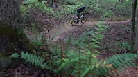
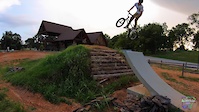
Videos of Rogers Mountain Bike
trail: Railyard Perimeter
0:08 |
185 |
Aug 28, 2021
trail: Karst Trail
0:24 |
78 |
Jul 29, 2021
trail: Karst Trail
0:02 |
892 |
Jul 8, 2021
trail: Railyard Perimeter
2:42 |
485 |
Aug 27, 2019

trail: Karst Trail
40:08 |
46 |
May 1, 2026 , Rogers

trail: Wolf Den East
14:43 |
23 |
May 1, 2026 , Rogers

trail: Tunnel Connector
15:16 |
46 |
May 1, 2026 , Rogers
9:12 |
14 |
May 1, 2026 , Rogers
Recent Trail Reports
| status | trail | date | condition | info | user |
|---|---|---|---|---|---|
| Little Clifty Creek Loop | Jun 21, 2026 @ 4:07pm (America/Chicago) 1 day | Variable | Mikie-imtbtrails | ||
| Bashore Ridge Point | Jun 19, 2026 @ 11:20am (America/Chicago) Jun 19, 2026 | Ideal | Mikie-imtbtrails | ||
| Bashore Ridge | Jun 19, 2026 @ 11:20am (America/Chicago) Jun 19, 2026 | Ideal | Mikie-imtbtrails | ||
| Dutton Hollow Loop | Jun 19, 2026 @ 11:20am (America/Chicago) Jun 19, 2026 | Ideal | Mikie-imtbtrails | ||
| Connector | Jun 19, 2026 @ 11:20am (America/Chicago) Jun 19, 2026 | Ideal | Mikie-imtbtrails | ||
| War Eagle Valley Loop | Jun 19, 2026 @ 11:20am (America/Chicago) Jun 19, 2026 | Ideal | Mikie-imtbtrails | ||
| Little Clifty Creek Access | Jun 19, 2026 @ 11:20am (America/Chicago) Jun 19, 2026 | Ideal | Mikie-imtbtrails | ||
| Controlled Burn | Jun 14, 2026 @ 2:24pm (America/Chicago) Jun 14, 2026 | Unknown | Nusfut | ||
| Backbone | Jun 14, 2026 @ 2:22pm (America/Chicago) Jun 14, 2026 | Variable | Nusfut | ||
| Wolf Den West | Jun 10, 2026 @ 2:18pm (America/Chicago) Jun 10, 2026 | Ideal | robbiethetrailtroll OORC |
Activity Feed
| username | action | type | title | date |
|---|---|---|---|---|
| Mikie-imtbtrails | add | report | activity #97535474 | Jun 21, 2026 @ 6:07pm 23 hours |
| Mikie-imtbtrails | add | report | activity #97438307 and 6 more | Jun 20, 2026 @ 3:37pm 2 days |
| gtowndude | wishlist | trail | activity #97385804 | Jun 20, 2026 @ 5:51am 2 days |
| gtowndude | wishlist | badge | activity #97244734 | Jun 18, 2026 @ 5:19am Jun 18, 2026 |
| lperry34 | ridden | trail | activity #97015389 | Jun 14, 2026 @ 5:33pm Jun 14, 2026 |
Recent Comments
| username | type | title | comment | date |
|---|---|---|---|---|
| trail | Looks fun but closed today (I was told for... | Nov 21, 2025 @ 9:26am Nov 21, 2025 | ||
| trail | Rode clockwise. | Oct 20, 2025 @ 1:15pm Oct 20, 2025 | ||
| trail | Don't ride this if you don't want to have fun!... | Oct 20, 2025 @ 1:10pm Oct 20, 2025 | ||
| trail | Maybe not "knock your socks off!", but lots of... | Oct 20, 2025 @ 1:06pm Oct 20, 2025 | ||
| trail | As good of a climb as you're going to find. | Oct 20, 2025 @ 1:00pm Oct 20, 2025 |
Local Badges
-

10 Blue Trails255 awarded -

Epic Ride Climb 2k4 awarded -

Climbing 10k Badge61 awarded -

Climbing 100k Badge3 awarded -

Epic Ride Descent 2k4 awarded -

Descent 10k Badge61 awarded
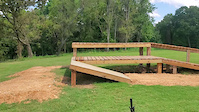
Bike & Skill Parks
| name | type | city | rating |
|---|---|---|---|
| The Rail Yard Bike Park | skill park | Rogers |
Activity Type Stats
| activitytype | trails | distance | descent | descent distance | total vertical | rating | global rank | state rank | photos | reports | routes | ridelogs |
|---|---|---|---|---|---|---|---|---|---|---|---|---|
| Mountain Bike | 120 | 91 miles | 6,572 ft | 34 miles | 295 ft | #909 | #356 | 351 | 1,187 | 10 | 21,523 | |
| E-Bike | 107 | 88 miles | 6,490 ft | 33 miles | 295 ft | #861 | #770 | 14 | 1,080 | 3 | 1,695 | |
| Horse | 2 | 5 miles | 568 ft | 2 miles | 243 ft | #2,560 | #1,416 | 86 | 1 | |||
| Hike | 123 | 96 miles | 7,293 ft | 37 miles | 295 ft | #2,094 | #877 | 7 | 1,148 | 937 | ||
| Trail Running | 123 | 96 miles | 7,293 ft | 37 miles | 295 ft | #1,608 | #553 | 2 | 1,148 | 1 | 1,866 |
Frequently Asked Questions About Rogers
▼
What are the best places to ride in Rogers?
Rogers has 2 areas to explore for mountain biking. The top rated areas are:
▼
What are the highest rated mountain biking trails in Rogers?
The highest rated mountain biking trails in Rogers are:
- Karst Trail (4.5/5)
- Wolf Den West (4.4/5)
- Railyard Perimeter (4.4/5)
- Timberjack (4.2/5)
- Groms (4.2/5)
▼
What is the best time of the year to ride in Rogers?
Based on ride log data, the most popular months to ride in Rogers are:
- October (192 activities)
- September (138 activities)
- April (136 activities)
▼
Where can I park to ride in Rogers?
There are 15 parking locations listed in Rogers. The most popular parking spots are: View all parking and trailhead locations on the map to plan your visit.
Activities
Trails
- By todd
 Trailforks & contributors
 - Admins: Trailblazers, FAST, OZ TRAILS, thomcerny
- #13008 - 9,170 views
- rogers activity log | embed map of Rogers mountain bike trails | rogers mountain biking points of interest
Downloading of trail gps tracks in kml & gpx formats is enabled for Rogers.
You must login to download files.