close
-
Layers w
- Weather Layers
- Pro
- Pro
- Pro
- Pro
- Pro
- Pro
- More Layers
- Pro
- Pro
- Pro
- Pro
-
Upgrade to

3D
Trail Conditions
- Unknown
- Snow Groomed
- Snow Packed
- Snow Covered
- Snow Cover Partial
- Freeze/thaw Cycle
- Icy
- Prevalent Mud
- Wet
- Variable
- Ideal
- Dry
- Very Dry
Trail Flow (Ridden Direction)
Trailforks scans users ridelogs to determine the most popular direction each trail is ridden. A good flowing trail network will have most trails flowing in a single direction according to their intension.
The colour categories are based on what percentage of riders are riding a trail in its intended direction.
The colour categories are based on what percentage of riders are riding a trail in its intended direction.
- > 96%
- > 90%
- > 80%
- > 70%
- > 50%
- < 50%
- bi-directional trail
- no data
Trail Last Ridden
Trailforks scans ridelogs to determine the last time a trail was ridden.
- < 2 days
- < 1 week
- < 2 weeks
- < 1 month
- < 6 months
- > 6 months
Trail Ridden Direction
The intended direction a trail should be ridden.
- Downhill Only
- Downhill Primary
- Both Directions
- Uphill Primary
- Uphill Only
- One Direction
Contribute Details
Colors indicate trail is missing specified detail.
- Description
- Photos
- Description & Photos
- Videos
Trail Popularity ?
Trailforks scans ridelogs to determine which trails are ridden the most in the last 9 months.
Trails are compared with nearby trails in the same city region with a possible 25 colour shades.
Think of this as a heatmap, more rides = more kinetic energy = warmer colors.
- most popular
- popular
- less popular
- not popular
ATV/ORV/OHV Filter
Max Vehicle Width
inches
US Cell Coverage
Legend

Radar Time
Activity Recordings
Trailforks uses anonymized public activity data.
?
Activity Recordings
Trailforks uses anonymized public activity data.
?
Personal Heatmap
▶
Activity Types
all
/
none
▶
Options
2
Date range
month
–
Winter Trails
Warning
A routing network for winter maps does not exist. Selecting trails using the winter trails layer has been disabled.
Missing Trails
Most Popular
Least Popular
Trails are colored based on popularity. The more popular a trail is, the more red. Less popular trails trend towards green.
Jump Magnitude Heatmap
Heatmap of where riders jump on trails. Zoom in to see individual jumps, click circles to view jump details.
BC Backroad Status
![map legend]()
Service Road Atlas is a free to use, community-driven service for viewing and creating reports on the numerous back-country service roads around B.C. and Alberta.

Slope Aspect
Direction the slope faces
Trails Deemphasized
Trails are shown in grey.
Only show trails with no bike usage.
Suggested Layers
Based on selected activity type
Save the current map location and zoom level as your default home location whenever this page is loaded.
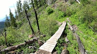
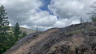
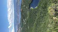
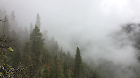
SaveRose Valley Regional Park has an extensive trail network that is marked by usage rather than signage. It is recommended for the moderately fit as there are some steep climbs and one should be aware there are some sudden steep drop-offs. Hikers should be aware that this is not a looped trail, so they will need to retrace their steps. Hikers will be rewarded with panoramic views, wildlife sightings and volcanic cliffs marked by caves that are believed to have been created by large air bubbles in the lava. There are plateaus of grassland, wooded areas and steep cliffs. For mountain bikers, there are no stunts in the regional park, but the ride rewards you with amazing views.
CAUTION: These trails are shared by hikers and mountain bikers. Take care to avoid contaminating the Rose Valley Reservoir – it is an important source of public water supply.
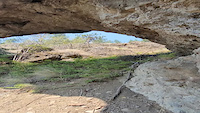
Features: volcanic cliffs, caves, flora & fauna, grassland plateau, panoramic views, Goldies Pond, man-made reservoir, bird watching, wildlife
CAUTION: These trails are shared by hikers and mountain bikers. Take care to avoid contaminating the Rose Valley Reservoir – it is an important source of public water supply.
Features: volcanic cliffs, caves, flora & fauna, grassland plateau, panoramic views, Goldies Pond, man-made reservoir, bird watching, wildlife
Primary Trail Type: Cross-Country
Land Status: Crown Land
 google parking directions
 Access Info:
The main access to the park is from Westlake Road near the pond and Rose Valley Elementary School. There is a small parking area to the south of the pond and across from the West Kelowna fire hall.
The popular mountain biking access is from Rosewood Drive by the new water reservoir, with a full parking lot, kiosk and bike servicing and washing equipment at the corner of Rosewood Drive and Rosealee Lane.
A new larger gated parking area is available in Spring, Summer and Fall (closed during winter months) at Westlake Road and Starlight Crescent. This parking area is closed each evening and opened each morning. Vehicles left in the lot after closing are subject to the Regional Parks Regulation Bylaw No. 1105 section 16 (15). After hours vehicle access and towing policy posted at lot entrance.
Links
Activities Click to view
- Mountain Bike
69 trails
- E-Bike
5 trails
- Hike
68 trails
- Trail Running
65 trails
Region Details
- 6
- 13
- 38
- 9
- 3
Region Status
Caution as of Jun 14, 2026Stats
- Avg Trail Rating
- Trails (view details)
- 70
- Trails Mountain Bike
- 69
- Trails E-Bike
- 5
- Trails Horse
- 1
- Trails Hike
- 68
- Trails Trail Running
- 65
- Trails Dirtbike/Moto
- 1
- Trails ATV/ORV/OHV
- 1
- Trails Snowmobile
- 1
- Trails Snowshoe
- 1
- Total Distance
- 53 miles
- Total Descent
- 13,638 ft
- Total Vertical
- 3,496 ft
- Highest Trailhead
- 4,997 ft
- Reports
- 2,142
- Photos
- 501
- Ridden Counter
- 18,512
Popular Rose Valley Mountain Biking Trails
• 90 ★ 4.6 • 3 miles • 1,323 ft • 891 •
So many switchbacks you'll be in a daze... This is a purpose built climb trail with plenty of switchbacks to keep the grade from getting too steep - there are a few short punchy sections to keep you on your toes though. There are plenty...
• 90 ★ 3.6 • 1 mile • 86 ft • 731 •
Nice alternative start to Rose Valley Around The Lake, or finish on if you're starting from .
Red Rock Permanently Closed
• 85 ★ 3.5 • 3,461 ft • 231 ft • 649 •
The last hard stretch to the top pf Rose Valley Trails. The view is worth the effort. Single tracks are wide and forgiving but there is some steep technical required in some sections. Originally known as "sh1t face", it's a bit of a...
Camels Hump Permanently Closed
• 90 ★ 3.0 • 2,204 ft • 211 ft • 601 •
Alternate to the connector which can get quite wet in the spring.
Swamp Donkey Permanently Closed
• 80 ★ 4.6 • 1 mile • 435 ft • 590 •
Great set of switch backs that climb out of Rose Valley reservoir and get you back to vehicles at the top of West Kelowna Rd or Rose Valley Elementary. Trail starts appx 100mtrs uphill from the lake shore via the main hiking trails and...
• 85 ★ 4.2 • 2 miles • 284 ft • 584 •
is the quickest trail from the top Rose Valley Peak to get to the Rose Valley Dam to continue the . Not overly technical but the last section of the trail is called and that 300 meters is better rated as advanced rather than intermediate.
The Elevator Permanently Closed
• 80 ★ 3.5 • 2,884 ft • 188 ft • 576 •
This connector works in both directions. On the way up you can avoid the peak and still make it down to the reservoir and on the way out you can connect to Rose Valley trails again without losing most of the altitude back down to the...
Rose Valley Mountain Bike Routes
★ 4.0 • 8 miles • 1,664 ft • 6 • Loop •
For this Sovereign Grouper we've got something for everyone - punchy climbs, loose switchbacks, tech rock...
★ 4.0 • 5 miles • 1,136 ft • 14 • Loop •
For SVRN Grouper Rose.BearBones we will be riding up Slick50 connecting into ending at the top of Redrock,...
★ 3.0 • 5 miles • 1,258 ft • 18 • Loop •
For SVRN Grouper Rose. #2 we will be riding up , coming down , and taking the easy out bypassing .
★ 1.0 • 7 miles • 1,306 ft • 4 • Loop •
This Sovereign Cycle group we plan to climb up to access the fun rock lines on the trail. We'll then...
8 miles • 1,476 ft • 6 • Loop •
On this Sovereign Cycle group ride we're sampling a couple trails from the East side of the network for...
8 miles • 2,025 ft • 9 • Loop •
Because two trails are better than one, on this Sovereign Cycle group ride we'll test our skill on a...
Photos of Rose Valley Mountain Bike
Videos of Rose Valley Mountain Bike
trail: No Left Turn Unstoned
2:21 |
|
Jun 24, 2023
trail: Daze Of Roses
0:21 |
47 |
Sep 3, 2022
trail: No Left Turn Unstoned
2:29 |
56 |
Jun 3, 2022
trail: City On The Edge Of Forever
0:09 |
148 |
Jul 25, 2021

trail: City On The Edge Of Forever
0:07 |
87 |
Jul 25, 2021
trail: Reservoir Backside
0:17 |
|
Jun 7, 2020
trail: City On The Edge Of Forever
0:29 |
|
Jul 1, 2019
trail: City On The Edge Of Forever
0:10 |
304 |
Nov 26, 2018
Current Trail Warnings
| status | trail | date | condition | user | info |
|---|---|---|---|---|---|
| No Left Turn Unstoned | Jun 14, 2026 @ 1:49pm (America/Vancouver) Jun 14, 2026 | Unknown | Trailbender | Overgrown vegetation, trail should be... |
Recent Trail Reports
Activity Feed
| username | action | type | title | date |
|---|---|---|---|---|
| Spyrus | comment | report | activity #97062958 | Jun 15, 2026 @ 1:35pm 2 days |
| Trailbender | comment | report | activity #97022379 | Jun 14, 2026 @ 9:30pm Jun 14, 2026 |
| Trailbender | comment | report | activity #97015388 | Jun 14, 2026 @ 5:33pm Jun 14, 2026 |
| Spyrus | comment | report | activity #97003765 | Jun 14, 2026 @ 2:11pm Jun 14, 2026 |
| Trailbender | add | report | activity #97002664 | Jun 14, 2026 @ 1:55pm Jun 14, 2026 |
Recent Comments
| username | type | title | comment | date |
|---|---|---|---|---|
| report | there's a nice way of saying it needs... | Jun 15, 2026 @ 1:35pm 2 days | ||
| report | Its pretty ridiculous you guys posting this... | Jun 14, 2026 @ 9:30pm Jun 14, 2026 | ||
| report | Actually do realize this, but if you're from... | Jun 14, 2026 @ 5:33pm Jun 14, 2026 | ||
| report | join the trail crew! | Jun 14, 2026 @ 2:11pm Jun 14, 2026 | ||
| report | Awesome. Thanks Doug! | Jun 13, 2026 @ 8:46pm Jun 13, 2026 |
Nearby Areas
| name | distance | ||||
|---|---|---|---|---|---|
| Bear Creek Provincial Park | 3 km | ||||
| Kalamoir Regional Park | 4 | 3.8 km | |||
| Knox Mountain Park | 19 | 21 | 6 | 1 | 4 km |
| Smith Creek | 5 | 10 | 9 | 4.8 km | |
| Knox Mountain Park East | 15 | 26 | 10 | 1 | 5.1 km |
Local Badges
-

Completionist0 awarded
Activity Type Stats
| activitytype | trails | distance | descent | descent distance | total vertical | rating | global rank | state rank | photos | reports | routes | ridelogs |
|---|---|---|---|---|---|---|---|---|---|---|---|---|
| Mountain Bike | 69 | 47 miles | 13,579 ft | 22 miles | 3,054 ft | #851 | #72 | 465 | 2,142 | 23 | 12,768 | |
| E-Bike | 5 | 5 miles | 1,079 ft | 2 miles | 2,700 ft | #4,165 | #154 | 6 | 1,630 | 1 | 735 | |
| Horse | 1 | 6 miles | 59 ft | 1,873 ft | 2,680 ft | 580 | ||||||
| Hike | 68 | 52 miles | 13,081 ft | 22 miles | 3,497 ft | #1,280 | #74 | 30 | 2,117 | 1 | 1,495 | |
| Trail Running | 65 | 51 miles | 12,874 ft | 21 miles | 3,497 ft | #2,270 | #68 | 2,115 | 1 | 836 | ||
| Dirtbike/Moto | 1 | 6 miles | 59 ft | 1,873 ft | 2,680 ft | 580 | 9 | |||||
| ATV/ORV/OHV | 1 | 6 miles | 59 ft | 1,873 ft | 2,680 ft | 580 | 4 | |||||
| Snowmobile | 1 | 6 miles | 59 ft | 1,873 ft | 2,680 ft | |||||||
| Snowshoe | 1 | 6 miles | 59 ft | 1,873 ft | 2,680 ft | 3 |
Frequently Asked Questions About Rose Valley
▼
What are the highest rated mountain biking trails in Rose Valley?
The highest rated mountain biking trails in Rose Valley are:
- Rock Candy (4.5/5)
- Daze Of Roses (4.4/5)
- Bear Bones (4.2/5)
- Turkey Vulture Loop (4.2/5)
- Jabbarocky (4.2/5)
▼
What is the best time of the year to ride in Rose Valley?
Based on ride log data, the most popular months to ride in Rose Valley are:
- April (308 activities)
- May (305 activities)
- July (263 activities)
▼
Where can I park to ride in Rose Valley?
There are 5 parking locations listed in Rose Valley. The most popular parking spots are:
- Parking
- Parking and bike wash (1949 Rosealee Lane)
- Rose Valley Parking (2040 Westlake Road)
- Top of Rosewood parking
- Parking
▼
What is the longest trail in Rose Valley?
The longest trail in Rose Valley is Lake Loop at 3.4 miles. View all trails sorted by distance.
Activities
Trails
Points of Interest
- By bcpunk
 CL IMBA Canada & contributors
 - Admins: MTBCOW, MTBco
- #6744 - 66,216 views
- rose valley activity log | embed map of Rose Valley mountain bike trails | rose valley mountain biking points of interest
Downloading of trail gps tracks in kml & gpx formats is enabled for Rose Valley.
You must login to download files.