close
-
Layers w
- Weather Layers
- Pro
- Pro
- Pro
- Pro
- Pro
- Pro
- More Layers
- Pro
- Pro
- Pro
- Pro
-
Upgrade to

3D
Trail Conditions
- Unknown
- Snow Groomed
- Snow Packed
- Snow Covered
- Snow Cover Partial
- Freeze/thaw Cycle
- Icy
- Prevalent Mud
- Wet
- Variable
- Ideal
- Dry
- Very Dry
Trail Flow (Ridden Direction)
Trailforks scans users ridelogs to determine the most popular direction each trail is ridden. A good flowing trail network will have most trails flowing in a single direction according to their intension.
The colour categories are based on what percentage of riders are riding a trail in its intended direction.
The colour categories are based on what percentage of riders are riding a trail in its intended direction.
- > 96%
- > 90%
- > 80%
- > 70%
- > 50%
- < 50%
- bi-directional trail
- no data
Trail Last Ridden
Trailforks scans ridelogs to determine the last time a trail was ridden.
- < 2 days
- < 1 week
- < 2 weeks
- < 1 month
- < 6 months
- > 6 months
Trail Ridden Direction
The intended direction a trail should be ridden.
- Downhill Only
- Downhill Primary
- Both Directions
- Uphill Primary
- Uphill Only
- One Direction
Contribute Details
Colors indicate trail is missing specified detail.
- Description
- Photos
- Description & Photos
- Videos
Trail Popularity ?
Trailforks scans ridelogs to determine which trails are ridden the most in the last 9 months.
Trails are compared with nearby trails in the same city region with a possible 25 colour shades.
Think of this as a heatmap, more rides = more kinetic energy = warmer colors.
- most popular
- popular
- less popular
- not popular
ATV/ORV/OHV Filter
Max Vehicle Width
inches
US Cell Coverage
Legend

Radar Time
Activity Recordings
Trailforks uses anonymized public activity data.
?
Activity Recordings
Trailforks uses anonymized public activity data.
?
Personal Heatmap
▶
Activity Types
all
/
none
▶
Options
2
Date range
month
–
Winter Trails
Warning
A routing network for winter maps does not exist. Selecting trails using the winter trails layer has been disabled.
Missing Trails
Most Popular
Least Popular
Trails are colored based on popularity. The more popular a trail is, the more red. Less popular trails trend towards green.
Jump Magnitude Heatmap
Heatmap of where riders jump on trails. Zoom in to see individual jumps, click circles to view jump details.
BC Backroad Status
![map legend]()
Service Road Atlas is a free to use, community-driven service for viewing and creating reports on the numerous back-country service roads around B.C. and Alberta.

Slope Aspect
Direction the slope faces
Trails Deemphasized
Trails are shown in grey.
Only show trails with no bike usage.
Suggested Layers
Based on selected activity type
Save the current map location and zoom level as your default home location whenever this page is loaded.
Save
No description for Roseburg has been added yet!
Login or register to submit one.
Activities Click to view
- Mountain Bike
36 trails
- E-Bike
3 trails
- Gravel Bike
0 trails
- Adaptive Bike
0 trails
- Horse
7 trails
- Hike
48 trails
- Trail Running
48 trails
- Dirtbike/Moto
1 trails
- ATV/ORV/OHV
1 trails
- Snowshoe
2 trails
Region Details
- 2
- 2
- 8
- 17
- 6
Region Status
Caution as of Jun 6, 2026Stats
- Avg Trail Rating
- Trails (view details)
- 41
- Trails Mountain Bike
- 36
- Trails E-Bike
- 3
- Trails Horse
- 7
- Trails Hike
- 48
- Trails Trail Running
- 48
- Trails Dirtbike/Moto
- 1
- Trails ATV/ORV/OHV
- 1
- Trails Snowshoe
- 2
- Trails Backcountry Ski
- 1
- Trails Nordic Ski
- 2
- Total Distance
- 141 miles
- Total Descent
- 25,347 ft
- Total Vertical
- 7,915 ft
- Highest Trailhead
- 8,349 ft
- Reports
- 233
- Photos
- 164
- Ridden Counter
- 1,303
Sub Regions
-
North Umpqua Trail
- 1
- 8
- 15
- 4
Popular Roseburg Mountain Biking Trails
• 80 ★ 4.4 • 12 miles • 594 ft • 122 •
Probably the most spectacular (and popular) of the North Umpqua Trail segments. The trail features fast downhills, technical rock gardens and punchy climbs. This segment has waterfall views and even a 'waterfall' rock garden on the...
• 95 ★ 3.4 • 9 miles • 1,304 ft • 96 •
No matter which direction you take it, there is one long, rolling climb and one long, rolling descent. Trail is surprisingly smooth, considering how many boulders there are along it! The high point on the trail is a rock outcropping...
• 90 ★ 0.0 • 2 miles • 321 ft • 93 •
Rolling section of trail through lush forest with big trees. Parts are close to the river. Trail surface is mostly smooth but there are some rocks and roots. Mostly fast, but there are a few short, punchy climbs that sneak up on you....
• 85 ★ 2.0 • 2 miles • 366 ft • 84 •
Rolling section of trail through lush forest with big trees. Parts are close to the river. Trail surface is mostly smooth but there are some rocks and roots. Mostly fast, but there are a few short, punchy climbs that sneak up on you....
• 100 ★ 5.0 • 11 miles • 525 ft • 68 •
Paved path around the entire lake. Minimal climbing and descending as the trail is mostly flat. This is a great family ride. The scenery is good, and, as you get away from the resort area, the trail is uncrowded.
• 5 ★ 5.0 • 3 miles • 487 ft • 57 •
This could easily be a black trail due to the up and down terrain.
• 5 ★ 3.4 • 5 miles • 189 ft • 48 •
Probably the most underrated segment of the North Umpqua Trail. It starts at the Kelsay Valley Trailhead. The first part meanders along the beginnings of the North Umpqua River, where wildflowers abound in springtime. It then pops out...
• 5 ★ 0.0 • 4 miles • 961 ft • 46 •
Trail segment follows the river through scenic forest. Recent fires have changed the landscape somewhat.
Roseburg Mountain Bike Routes
69 miles • 8,844 ft • 6 •
• 19 miles • 3,893 ft • 3 •
• 12 miles • 539 ft • 0 •
• 10 miles • 761 ft • 2 •
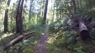
Photos of Roseburg Mountain Bike
Videos of Roseburg Mountain Bike
17:56 |
546 |
Jan 15, 2018
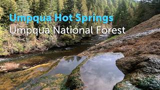
trail: Umpqua Hot Springs
2:48 |
12 |
Mar 12, 2026 , Roseburg
Recent Trail Reports
| status | trail | date | condition | info | user |
|---|---|---|---|---|---|
| North Umpqua Trail - Deer Leap Segment | Jun 6, 2026 @ 6:03pm (America/Los_Angeles) Jun 6, 2026 | Dry | Barry0ezCMo | ||
| Windigo Pass | Nov 14, 2025 @ 7:42am (America/Los_Angeles) Nov 14, 2025 | Ideal | ifrankie | ||
| Lemolo Lake Extension | Sep 23, 2025 @ 5:10pm (America/Los_Angeles) Sep 23, 2025 | Ideal | scottmorris | ||
| Lemolo Lake | Sep 23, 2025 @ 5:10pm (America/Los_Angeles) Sep 23, 2025 | Ideal | scottmorris | ||
| Lemolo Lake | Sep 23, 2025 @ 5:10pm (America/Los_Angeles) Sep 23, 2025 | Ideal | scottmorris | ||
| North Umpqua Trail - Dread and Terror Segment | Aug 19, 2025 @ 9:56am Aug 19, 2025 | Ideal | bdc101 | ||
| Dread and Terror | Aug 19, 2025 @ 9:56am Aug 19, 2025 | Ideal | bdc101 | ||
| North Umpqua Trail - Lemolo Segment | Aug 19, 2025 @ 9:56am Aug 19, 2025 | Ideal | bdc101 | ||
| Lemolo Falls | Aug 19, 2025 @ 9:56am Aug 19, 2025 | Ideal | bdc101 | ||
| Silent Creek Trail | Aug 6, 2025 @ 3:44pm Aug 6, 2025 | Ideal | twrenz57 |
Activity Feed
| username | action | type | title | date |
|---|---|---|---|---|
| 5R7vNkMp | vote | trail | activity #97067260 | Jun 15, 2026 @ 2:57pm Jun 15, 2026 |
| Barry0ezCMo | comment | trail | activity #96420844 | Jun 6, 2026 @ 6:10pm Jun 6, 2026 |
| Barry0ezCMo | add | report | activity #96420436 and 1 more | Jun 6, 2026 @ 6:01pm Jun 6, 2026 |
| BrandonxaCMIz | wishlist | trail | activity #95122422 | May 20, 2026 @ 11:26am May 20, 2026 |
| BillR10nng | wishlist | trail | activity #94948172 | May 17, 2026 @ 4:17pm May 17, 2026 |
Recent Comments
| username | type | title | comment | date |
|---|---|---|---|---|
| trail | Rode 6/4/26 from Toketee TH to Slip Creek... | Jun 6, 2026 @ 6:10pm Jun 6, 2026 | ||
| trail | Trail described as accessible but many... | Aug 12, 2025 @ 1:53pm Aug 12, 2025 | ||
| report | There's one downd tree..... | Jul 29, 2025 @ 9:51am Jul 29, 2025 | ||
| trail | Attempted from horseshoe bend campground,... | Jul 13, 2025 @ 8:58am Jul 13, 2025 | ||
| trail | Not clear. Attempted riding from the "end" got... | Jul 12, 2025 @ 5:17pm Jul 12, 2025 |
Local Badges
-

10 Blue Trails4 awarded -

Epic Ride Climb 2k27 awarded -

Climbing 10k Badge6 awarded -

Climbing 100k Badge0 awarded -

Epic Ride Descent 2k42 awarded -

Descent 10k Badge6 awarded
Activity Type Stats
| activitytype | trails | distance | descent | descent distance | total vertical | rating | global rank | state rank | photos | reports | routes | ridelogs |
|---|---|---|---|---|---|---|---|---|---|---|---|---|
| Mountain Bike | 36 | 120 miles | 23,881 ft | 60 miles | 5,407 ft | #2,500 | #896 | 159 | 229 | 1 | 2,018 | |
| E-Bike | 3 | 6 miles | 1,007 ft | 3 miles | 1,768 ft | #7,848 | #2,369 | 49 | 40 | |||
| Horse | 7 | 23 miles | 5,755 ft | 13 miles | 5,151 ft | #1,709 | #974 | 41 | ||||
| Hike | 48 | 138 miles | 25,322 ft | 64 miles | 7,917 ft | #666 | #308 | 4 | 233 | 580 | ||
| Trail Running | 48 | 138 miles | 25,322 ft | 64 miles | 7,917 ft | #1,414 | #507 | 233 | 339 | |||
| Dirtbike/Moto | 1 | 5 miles | 974 ft | 3 miles | 738 ft | #1,219 | #495 | 31 | 3 | |||
| ATV/ORV/OHV | 1 | 5 miles | 974 ft | 3 miles | 738 ft | #928 | #427 | 31 | 2 | |||
| Snowshoe | 2 | 4 miles | 26 ft | 1,043 ft | 627 ft | #1,621 | #924 | 3 | ||||
| Backcountry Ski | 1 | 4 miles | 26 ft | 1,043 ft | 627 ft | 4 | 86 | |||||
| Nordic Ski | 2 | 4 miles | 26 ft | 1,043 ft | 627 ft | 11 |
Frequently Asked Questions About Roseburg
▼
What are the best places to ride in Roseburg?
Roseburg has 2 areas to explore for mountain biking. The top rated areas are:
▼
What are the highest rated mountain biking trails in Roseburg?
The highest rated mountain biking trails in Roseburg are:
- North Umpqua Trail - Dread and Terror Segment (4.2/5)
- Dellenback Bike Path (4.1/5)
- North Umpqua Trail - Tioga Segment (4.1/5)
- North Umpqua Trail - Jessie Wright Segment (4.1/5)
- North Umpqua Trail - Calf Segment (4.1/5)
▼
What is the best time of the year to ride in Roseburg?
Based on ride log data, the most popular months to ride in Roseburg are:
- July (30 activities)
- June (23 activities)
- September (21 activities)
▼
Where can I park to ride in Roseburg?
There are 23 parking locations listed in Roseburg. The most popular parking spots are: View all parking and trailhead locations on the map to plan your visit.
Activities
Trails
Points of Interest
- Terwilliger (Cougar) Hot Springs Shelter Cabin
- Terwilliger (Cougar) Hot Springs Other
- National Falls Viewpoint
- [falls] National Falls Other
- Watson Falls Sight
- People Creek Campground Camping
- Toketee Falls Sight
- Kelsay Valley Trailhead Campground Camping
- Fall Creek Falls Sight
- Susan Creek Falls Sight
- Mount Bailey (2,551 m)
- Garwood Butte (2,113 m)
- Sherwood Butte (2,100 m)
- By ACree
 & contributors
 - Admins: SWO Admin
- #6116 - 7,181 views
- roseburg activity log | embed map of Roseburg mountain bike trails | roseburg mountain biking points of interest
Downloading of trail gps tracks in kml & gpx formats is enabled for Roseburg.
You must login to download files.