close
-
Layers w
- Weather Layers
- Pro
- Pro
- Pro
- Pro
- Pro
- Pro
- More Layers
- Pro
- Pro
- Pro
- Pro
-
Upgrade to

3D
Trail Conditions
- Unknown
- Snow Groomed
- Snow Packed
- Snow Covered
- Snow Cover Partial
- Freeze/thaw Cycle
- Icy
- Prevalent Mud
- Wet
- Variable
- Ideal
- Dry
- Very Dry
Trail Flow (Ridden Direction)
Trailforks scans users ridelogs to determine the most popular direction each trail is ridden. A good flowing trail network will have most trails flowing in a single direction according to their intension.
The colour categories are based on what percentage of riders are riding a trail in its intended direction.
The colour categories are based on what percentage of riders are riding a trail in its intended direction.
- > 96%
- > 90%
- > 80%
- > 70%
- > 50%
- < 50%
- bi-directional trail
- no data
Trail Last Ridden
Trailforks scans ridelogs to determine the last time a trail was ridden.
- < 2 days
- < 1 week
- < 2 weeks
- < 1 month
- < 6 months
- > 6 months
Trail Ridden Direction
The intended direction a trail should be ridden.
- Downhill Only
- Downhill Primary
- Both Directions
- Uphill Primary
- Uphill Only
- One Direction
Contribute Details
Colors indicate trail is missing specified detail.
- Description
- Photos
- Description & Photos
- Videos
Trail Popularity ?
Trailforks scans ridelogs to determine which trails are ridden the most in the last 9 months.
Trails are compared with nearby trails in the same city region with a possible 25 colour shades.
Think of this as a heatmap, more rides = more kinetic energy = warmer colors.
- most popular
- popular
- less popular
- not popular
ATV/ORV/OHV Filter
Max Vehicle Width
inches
US Cell Coverage
Legend

Radar Time
Activity Recordings
Trailforks uses anonymized public activity data.
?
Activity Recordings
Trailforks uses anonymized public activity data.
?
Personal Heatmap
▶
Activity Types
all
/
none
▶
Options
2
Date range
month
–
Winter Trails
Warning
A routing network for winter maps does not exist. Selecting trails using the winter trails layer has been disabled.
Missing Trails
Most Popular
Least Popular
Trails are colored based on popularity. The more popular a trail is, the more red. Less popular trails trend towards green.
Jump Magnitude Heatmap
Heatmap of where riders jump on trails. Zoom in to see individual jumps, click circles to view jump details.
BC Backroad Status
![map legend]()
Service Road Atlas is a free to use, community-driven service for viewing and creating reports on the numerous back-country service roads around B.C. and Alberta.

Slope Aspect
Direction the slope faces
Trails Deemphasized
Trails are shown in grey.
Only show trails with no bike usage.
Suggested Layers
Based on selected activity type
Save the current map location and zoom level as your default home location whenever this page is loaded.
Save
No description for Rosignano Marittimo has been added yet!
Login or register to submit one.
This region uses the Uk/Euro style trail grading system.
Activities Click to view
- Mountain Bike
170 trails
- E-Bike
170 trails
- Adaptive Bike
- Winter Fat Bike
0 trails
- Horse
20 trails
- Hike
103 trails
- Trail Running
78 trails
Region Details
- 34
- 14
- 24
Region Status
Caution as of Jun 20, 2026Stats
- Avg Trail Rating
- Trails (view details)
- 79
- Trails Mountain Bike
- 176
- Trails E-Bike
- 170
- Trails Horse
- 20
- Trails Hike
- 103
- Trails Trail Running
- 78
- Total Distance
- 39 miles
- Total Descent
- 11,184 ft
- Total Vertical
- 1,153 ft
- Highest Trailhead
- 1,213 ft
- Reports
- 1,540
- Photos
- 32
- Ridden Counter
- 4,998
Sub Regions
-
Rosignano Trail Area
- 13
- 19
Popular Rosignano Marittimo Mountain Biking Trails
• 95 ★ 4.7 • 1 mile • 12 ft • 135 •
Il trail piú flow e veloce della zona. Inizia come una versione piú facile de (terreno e pietre smosse), poi sorpassato e diventa completamente in terreno battuto e si va a cannone tra curve in roller coaster e piccoli salti, infine...
• 100 ★ 5.0 • 1 mile • 0 ft • 130 •
Trail di recente realizzazione che collega la cima del ai trail 3 - 4 - Kris/ e Curvone
• 90 ★ 4.4 • 486 ft • 0 ft • 107 •
Highly rated popular blue difficulty singletrack. This mountain bike primary trail can be used downhill primary and has a moderate overall physical rating. It features rock garden. On average it takes 6 minutes to complete this trail.
• 95 ★ 4.2 • 1,463 ft • 16 ft • 97 •
Trail recentemente ripristinato. Misto su roccia e terra che drena bene la pioggia, passaggi tecnici molteplici, parte finale con ripido e drop in sequenza (copiabile a basse velocità). Da unire a o .
• 85 ★ 4.5 • 4,695 ft • 0 ft • 96 •
Trail in terreno battuto molto flow e veloce, con una serie di piccoli salti lungo il percorso, adatti anche a principianti.
• 90 ★ 4.0 • 269 ft • 0 ft • 92 •
Popular blue difficulty gravel path. This mountain bike primary trail can be used downhill only. It features jump. On average it takes 2 minutes to complete this trail.
• 80 ★ 4.0 • 328 ft • 0 ft • 63 •
Popular blue difficulty singletrack. This mountain bike primary trail can be used downhill only. On average it takes minutes to complete this trail.
Rosignano Marittimo Mountain Bike Routes
★ 5.0 • 1 mile • 4 ft • 0 • Point to Point •
Permette di scendere dal Pelato fino alla strada che porta a Castiglioncello.
★ 5.0 • 2 miles • 817 ft • 0 • Point to Point •
Dall'alta via di Pian dei Lupi fino al campeggio di Fortullino sotto il ponte della superstrada.
Photos of Rosignano Marittimo Mountain Bike
Videos of Rosignano Marittimo Mountain Bike
youtuber
![Sir Robert - Poggio Pelato 2/5/'26]()
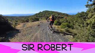
trail: Sir Robert
3:29 |
18 |
May 2, 2026 , Rosignano Marittimo
youtuber
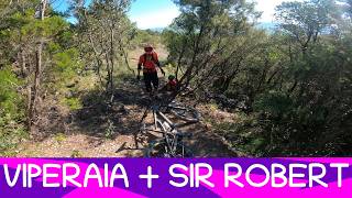
![Viperaia - Poggio Pelato 2/5/'26]()
trail: Sir Robert
2:45 |
18 |
May 2, 2026 , Rosignano Marittimo
youtuber
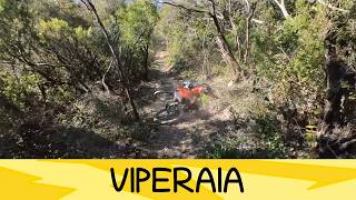
![MTB Poggio Pelato 02.05.2026 sentiero VIPERAIA...]()
trail: Sir Robert
6:26 |
22 |
May 2, 2026 , Rosignano Marittimo
youtuber
![Pietraia - Poggio Pelato 2/5/'26]()
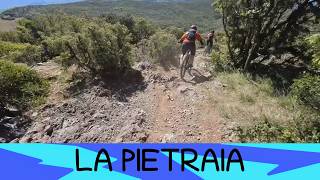
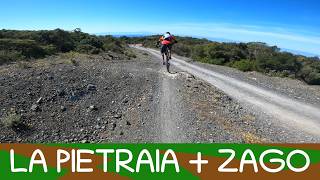
trail: La Pietraia
0:48 |
31 |
May 2, 2026 , Rosignano Marittimo
youtuber
![MTB Poggio Pelato 02.05.2026 sentiero LA...]()

trail: La Pietraia
4:45 |
23 |
May 2, 2026 , Rosignano Marittimo
youtuber
![Belvedere 2/5/'26]()
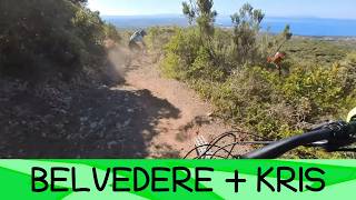
trail: Belvedere/Kris
6:38 |
58 |
May 2, 2026 , Rosignano Marittimo
Recent Trail Reports
| status | trail | date | condition | info | user |
|---|---|---|---|---|---|
| Sir Robert | Jun 21, 2026 @ 7:39am (Europe/San_Marino) Jun 20, 2026 | Dry | nadir63 | ||
| Belvedere/Kris | Jun 21, 2026 @ 7:39am (Europe/San_Marino) Jun 20, 2026 | Dry | nadir63 | ||
| Poggio Pelato | Jun 21, 2026 @ 7:39am (Europe/San_Marino) Jun 20, 2026 | Very Dry | nadir63 | ||
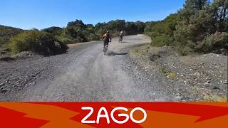
| Zago | Jun 21, 2026 @ 7:39am (Europe/San_Marino) Jun 20, 2026 | Dry | nadir63 | ||
| Massaccio | Jun 19, 2026 @ 7:01am (Europe/Rome) Jun 18, 2026 | Ideal | Ocram1959 | ||
| Raccordo | Jun 19, 2026 @ 7:01am (Europe/Rome) Jun 18, 2026 | Dry | Ocram1959 | ||
| Link Sir Robert - Zago | Jun 19, 2026 @ 7:01am (Europe/Rome) Jun 18, 2026 | Ideal | Ocram1959 | ||
| Access Mua | Jun 19, 2026 @ 7:01am (Europe/Rome) Jun 18, 2026 | Ideal | Ocram1959 | ||
| Cani | Jun 19, 2026 @ 7:01am (Europe/Rome) Jun 18, 2026 | Ideal | Ocram1959 | ||
| Pian Dei Lupi Sud | Jun 14, 2026 @ 7:48am (Europe/Rome) Jun 13, 2026 | Ideal | Ocram1959 |
Activity Feed
| username | action | type | title | date |
|---|---|---|---|---|
| RetoJZFPcg | wishlist | trail | activity #97510522 | Jun 21, 2026 @ 12:28pm Jun 21, 2026 |
| nadir63 | add | report | activity #97468316 and 3 more | Jun 21, 2026 @ 3:34am Jun 21, 2026 |
| Ocram1959 | add | report | activity #97303928 | Jun 19, 2026 @ 2:24am Jun 19, 2026 |
| Ocram1959 | add | report | activity #97303927 and 3 more | Jun 19, 2026 @ 2:24am Jun 19, 2026 |
| Ocram1959 | add | report | activity #96949053 and 1 more | Jun 14, 2026 @ 3:05am Jun 14, 2026 |
Recent Comments
| username | type | title | comment | date |
|---|---|---|---|---|
| trail | Hi, the Trailforks (IMBA) classification has... | Mar 30, 2026 @ 9:26am Mar 30, 2026 | ||
| trail | Good trail, would rated light black or dark blue. | Nov 29, 2025 @ 6:41am Nov 29, 2025 | ||
| trail | Similar to Kris/Miniera and Sir Robert trail,... | Nov 29, 2025 @ 4:43am Nov 29, 2025 | ||
| trail | Perfect flow in an old halfpipe! Similar to... | Nov 29, 2025 @ 4:37am Nov 29, 2025 | ||
| trail | Would rated easier than very difficult. Couple... | Nov 29, 2025 @ 4:35am Nov 29, 2025 |
Local Badges
-

Completionist0 awarded -

10 Blue Trails22 awarded -

10 Green Trails11 awarded -

Epic Mountain Bike Climb 2k14 awarded -

Climbing 10k Badge12 awarded -

Mountain Biking 100k Badge1 awarded
Activity Type Stats
| activitytype | trails | distance | descent | descent distance | total vertical | rating | global rank | state rank | photos | reports | routes | ridelogs |
|---|---|---|---|---|---|---|---|---|---|---|---|---|
| Mountain Bike | 170 | 39 miles | 11,184 ft | 24 miles | 1,155 ft | #2,842 | #138 | 30 | 1,583 | 2 | 2,793 | |
| E-Bike | 170 | 38 miles | 10,745 ft | 23 miles | 1,155 ft | #1,874 | #183 | 2 | 1,576 | 2 | 1,177 | |
| Horse | 20 | 6 miles | 774 ft | 2 miles | 840 ft | #2,375 | #163 | 20 | ||||
| Hike | 103 | 26 miles | 7,461 ft | 16 miles | 1,138 ft | #5,348 | #239 | 1,514 | 1 | 41 | ||
| Trail Running | 78 | 21 miles | 4,918 ft | 12 miles | 1,135 ft | #5,705 | #298 | 1,485 | 1 | 17 |
Frequently Asked Questions About Rosignano Marittimo
▼
What are the best places to ride in Rosignano Marittimo?
Rosignano Marittimo has 1 areas to explore for mountain biking. The top rated areas are:
▼
What are the highest rated mountain biking trails in Rosignano Marittimo?
The highest rated mountain biking trails in Rosignano Marittimo are:
- Belvedere/Kris (4.5/5)
- Sir Robert (4.5/5)
- Zago (4.3/5)
- La Stretta (4.2/5)
- Big Bang (4.1/5)
▼
What is the best time of the year to ride in Rosignano Marittimo?
Based on ride log data, the most popular months to ride in Rosignano Marittimo are:
- February (11 activities)
- August (9 activities)
- April (8 activities)
▼
Where can I park to ride in Rosignano Marittimo?
Activities
Trails
Points of Interest
- By ManuelVitiello
 & contributors
 - Admins: DanielePracchia
- #53826 - 1,384 views
- rosignano marittimo activity log | embed map of Rosignano Marittimo mountain bike trails | rosignano marittimo mountain biking points of interest
Downloading of trail gps tracks in kml & gpx formats is enabled for Rosignano Marittimo.
You must login to download files.