close
-
Layers w
- Weather Layers
- Pro
- Pro
- Pro
- Pro
- Pro
- Pro
- More Layers
- Pro
- Pro
- Pro
- Pro
-
Upgrade to

3D
Trail Conditions
- Unknown
- Snow Groomed
- Snow Packed
- Snow Covered
- Snow Cover Partial
- Freeze/thaw Cycle
- Icy
- Prevalent Mud
- Wet
- Variable
- Ideal
- Dry
- Very Dry
Trail Flow (Ridden Direction)
Trailforks scans users ridelogs to determine the most popular direction each trail is ridden. A good flowing trail network will have most trails flowing in a single direction according to their intension.
The colour categories are based on what percentage of riders are riding a trail in its intended direction.
The colour categories are based on what percentage of riders are riding a trail in its intended direction.
- > 96%
- > 90%
- > 80%
- > 70%
- > 50%
- < 50%
- bi-directional trail
- no data
Trail Last Ridden
Trailforks scans ridelogs to determine the last time a trail was ridden.
- < 2 days
- < 1 week
- < 2 weeks
- < 1 month
- < 6 months
- > 6 months
Trail Ridden Direction
The intended direction a trail should be ridden.
- Downhill Only
- Downhill Primary
- Both Directions
- Uphill Primary
- Uphill Only
- One Direction
Contribute Details
Colors indicate trail is missing specified detail.
- Description
- Photos
- Description & Photos
- Videos
Trail Popularity ?
Trailforks scans ridelogs to determine which trails are ridden the most in the last 9 months.
Trails are compared with nearby trails in the same city region with a possible 25 colour shades.
Think of this as a heatmap, more rides = more kinetic energy = warmer colors.
- most popular
- popular
- less popular
- not popular
ATV/ORV/OHV Filter
Max Vehicle Width
inches
US Cell Coverage
Legend

Radar Time
Activity Recordings
Trailforks uses anonymized public activity data.
?
Activity Recordings
Trailforks uses anonymized public activity data.
?
Personal Heatmap
▶
Activity Types
all
/
none
▶
Options
2
Date range
month
–
Winter Trails
Warning
A routing network for winter maps does not exist. Selecting trails using the winter trails layer has been disabled.
Missing Trails
Most Popular
Least Popular
Trails are colored based on popularity. The more popular a trail is, the more red. Less popular trails trend towards green.
Jump Magnitude Heatmap
Heatmap of where riders jump on trails. Zoom in to see individual jumps, click circles to view jump details.
BC Backroad Status
![map legend]()
Service Road Atlas is a free to use, community-driven service for viewing and creating reports on the numerous back-country service roads around B.C. and Alberta.

Slope Aspect
Direction the slope faces
Trails Deemphasized
Trails are shown in grey.
Only show trails with no bike usage.
Suggested Layers
Based on selected activity type
Save the current map location and zoom level as your default home location whenever this page is loaded.
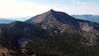
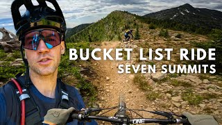
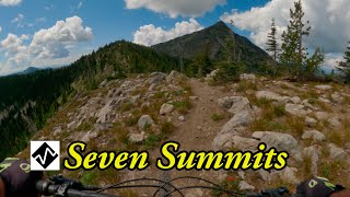
SaveThe Seven Summits trail, completed in the summer of 2004 by the Kootenay Columbia Trails Society (KCTS), is a spectacular point to point single-track traverse of the Rossland Range. Widely acclaimed by mountain bikers, acknowledged by the International Mountain Biking Association as an official Epic, and awarded the 2007 ‘Trail of the Year’ by Bike magazine, it is the crown jewel of the Rossland trail network. Challenging, adventurous, and spectacular, it is a true epic ride.
This riding area consists of the main Seven Summits trail, the optional portions and the Dewdney trail at the end.
This riding area consists of the main Seven Summits trail, the optional portions and the Dewdney trail at the end.
Primary Trail Type: Cross-Country
AKA: 7 Summits
 google parking directions
Links
Activities Click to view
- Mountain Bike
14 trails
- E-Bike
9 trails
- Hike
18 trails
- Trail Running
18 trails
- Snowshoe
4 trails
- Nordic Ski
4 trails
Region Details
- 4
- 1
- 2
- 1
- 6
Region Status
Caution as of Jun 14, 2026Stats
- Avg Trail Rating
- Trails (view details)
- 18
- Trails Mountain Bike
- 14
- Trails E-Bike
- 9
- Trails Horse
- 3
- Trails Hike
- 18
- Trails Trail Running
- 18
- Trails Dirtbike/Moto
- 1
- Trails ATV/ORV/OHV
- 1
- Trails Snowshoe
- 4
- Trails Backcountry Ski
- 3
- Trails Nordic Ski
- 4
- Total Distance
- 51 miles
- Total Descent
- 13,934 ft
- Total Vertical
- 5,424 ft
- Highest Trailhead
- 7,780 ft
- Reports
- 430
- Photos
- 489
- Ridden Counter
- 7,227
Articles

104km Adventure Across Interior BC's Rossland Range in a Day
Jul 27, 2019 from pinkbike.com
Sufferfest.
Popular Rossland Range Mountain Biking Trails
• 80 ★ 4.5 • 4 miles • 0 ft • 1,723 •
The trail was originally built nearly 150 years ago, and although the current route utilizes only small sections of the original prospector route, the historic character of the trail is difficult to escape. Today, the KCTS maintains and...
• 75 ★ 4.4 • 18 miles • 3,585 ft • 1,605 •
The trail, completed in the summer of 2004 by the Kootenay Columbia Trails Society (KCTS), is a spectacular point to point single-track traverse of the Rossland Range. Widely acclaimed by mountain bikers, acknowledged by the...
• 5 ★ 0.0 • 2 miles • 1,387 ft • 707 •
Less popular black diamond difficulty singletrack. This mountain bike primary trail can be used both directions and has a hard overall physical rating with a 1,387 ft black diamond climb. On average it takes 57 minutes to complete this trail.
• 5 ★ 0.0 • 2 miles • 648 ft • 677 •
Winter specific route for fat biking up/down the trail.
• 90 ★ 4.9 • 5 miles • 844 ft • 395 •
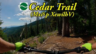
This finally (as of September 29th, 2023) completed upper section of Mxiɬp Xewílh (Cedar Trail) is Rossland's premier "moderate" trail. Entirely machine built, it rolls, dips and flows through sections of spectacular Old Growth...
• 40 ★ 3.3 • 3 miles • 4 ft • 132 • • hike
Primarily a hiking trail to access the Old Glory Summit or simply to gain the Ridge views. This trail is varied with steep sections of walking through the forest. As hikers gain elevation they reach the open Basin, trees become sparse...
• 45 ★ 0.0 • 3,642 ft • 46 ft • 74 •
Moderately popular white difficulty family friendly gravel path. This multi-use trail can be used both directions and has a easy overall physical rating with a 46 ft green climb. Adaptive MTB rating: amtb green. Trail visibility is always easy to follow. On average it takes 8 minutes to complete this trail.
• 40 ★ 3.0 • 2 miles • 1,110 ft • 66 • • hike
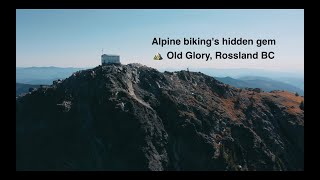
This is a Rossland Range classic trail which takes hikers to the highest summit in the Rossland Range. An old white weather station greets hikers at the top which showcases beautiful views of the region. The trail is narrow and steep in...
Rossland Range Mountain Bike Routes
★ 4.0 • 22 miles • 3,914 ft • 5 • Shuttled •
The trail followed by .
★ 5.0 • 38 miles • 7,280 ft • 28 • Loop •
A long ride, almost all singletrack. Redtop up and down, Caldera, Eddie J, lower Mongoose, KC, Techno...
98 miles • 10,381 ft • 5 • Point to Point •
Planned bikepacking route
60 miles • 8,924 ft • 4 • Point to Point •
Planned bikepacking route
22 miles • 3,917 ft • 4 • Race •
The third stage is a real treat and all-around adventure, utilizing the famous Trail; an IMBA epic. A...
• 3 miles • 176 ft • 1 •
Photos of Rossland Range Mountain Bike
Videos of Rossland Range Mountain Bike
trail: Upper Old Glory Trail
3:52 |
36 |
Oct 12, 2023
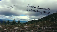
trail: Seven Summits
11:23 |
266 |
Apr 6, 2020
trail: Seven Summits
0:00 |
470 |
Jul 19, 2019
trail: Upper Mxiɬp Xewílh
4:26 |
39 |
Sep 23, 2025 , Rossland
youtuber
![Best mountain bike flow trail in Rossland, BC...]()
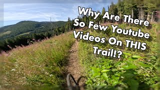
trail: Upper Mxiɬp Xewílh
19:50 |
195 |
Aug 29, 2025 , Rossland
youtuber
![One of the World’s Best Backcountry MTB...]()
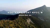
trail: Seven Summits
47:01 |
349 |
Aug 14, 2025 , Rossland
trail: Old Glory Trail (lower)
3:53 |
125 |
May 18, 2024 , Rossland
youtuber
![Seven Summits and Dewdney]()
trail: The Dewdney Trail
16:14 |
227 |
Jul 21, 2023 , Rossland
Recent Trail Reports
| status | trail | date | condition | info | user |
|---|---|---|---|---|---|
| Seven Summits | Jun 14, 2026 @ 7:56am (America/Vancouver) Jun 14, 2026 | Ideal | freerideposer KCTS | ||
| Plewman Trail | Jun 12, 2026 @ 6:18am (America/Vancouver) Jun 12, 2026 | Ideal | stewspooner KCTS | ||
| Upper Mxiɬp Xewílh | Jun 1, 2026 @ 5:19pm (America/Vancouver) Jun 1, 2026 | Ideal | stewspooner KCTS | ||
| The Dewdney Trail | May 30, 2026 @ 6:32pm (America/Vancouver) May 30, 2026 | Unknown | timeh69 RED | ||
| Old Glory Trail (lower) | May 25, 2026 @ 8:36am (America/Vancouver) May 25, 2026 | Dry | freerideposer KCTS | ||
| Sheep Creek | Sep 9, 2025 @ 9:08pm Sep 9, 2025 | Dry | greennorth | ||
| Upper Old Glory Trail | Jul 20, 2025 @ 1:30pm Jul 20, 2025 | Wet | timeh69 RED | ||
| Accessible Trail | Jul 19, 2025 @ 6:00am Jul 19, 2025 | Ideal | barbtyers | ||
| Nancy Greene Lake Loop | Jul 15, 2025 @ 6:52pm Jul 15, 2025 | Ideal | Bricklin69 | ||
| Elgood Spur FSR | Feb 15, 2024 @ 11:07am Feb 15, 2024 | Unknown | zLFJMR |
Activity Feed
| username | action | type | title | date |
|---|---|---|---|---|
| Parker23SitO | ridden | trail | activity #97063369 | Jun 15, 2026 @ 1:44pm 3 days |
| crobbin | wishlist | trail | activity #97054714 | Jun 15, 2026 @ 11:20am 3 days |
| freerideposer | add | report | activity #96968975 | Jun 14, 2026 @ 7:57am Jun 14, 2026 |
| freerideposer | comment | report | activity #96870941 | Jun 13, 2026 @ 6:44am Jun 13, 2026 |
| wildedge586 | wishlist | trail | activity #96855550 | Jun 13, 2026 @ 2:14am Jun 13, 2026 |
Recent Comments
| username | type | title | comment | date |
|---|---|---|---|---|
| report | Yes. Given this report, there will not be a... | Jun 13, 2026 @ 6:44am Jun 13, 2026 | ||
| report | How far up did you get? | Jun 12, 2026 @ 4:00pm Jun 12, 2026 | ||
| report | I saw a lot of mtb tire tracks up to just... | Jun 11, 2026 @ 4:51pm Jun 11, 2026 | ||
| report | That’s pretty high up. Best guess do you... | Jun 10, 2026 @ 6:54am Jun 10, 2026 | ||
| trail | What time of year does this ride typically... | Jan 16, 2026 @ 4:49pm Jan 16, 2026 |
Nearby Areas
| name | distance | ||||
|---|---|---|---|---|---|
| Neptune Creek | 2 | 3 | 2 | 3.8 km | |
| Red Mountain Resort Bike Park | 3 | 7 | 4 | 1 | 5.1 km |
| Red Mountain Community Trails | 2 | 8 | 2 | 6.4 km | |
| Monte Christo - KC | 7 | 25 | 11 | 4 | 7.3 km |
| Downtown Rossland | 9 | 4 | 7.4 km |
Activity Type Stats
| activitytype | trails | distance | descent | descent distance | total vertical | rating | global rank | state rank | photos | reports | routes | ridelogs |
|---|---|---|---|---|---|---|---|---|---|---|---|---|
| Mountain Bike | 14 | 47 miles | 13,494 ft | 26 miles | 4,869 ft | #3,218 | #151 | 408 | 427 | 5 | 2,808 | |
| E-Bike | 9 | 20 miles | 6,831 ft | 13 miles | 3,629 ft | #4,179 | #156 | 288 | 70 | |||
| Horse | 3 | 22 miles | 6,572 ft | 13 miles | 2,664 ft | 204 | ||||||
| Hike | 18 | 51 miles | 13,934 ft | 26 miles | 5,423 ft | #1,776 | #90 | 72 | 430 | 556 | ||
| Trail Running | 18 | 51 miles | 13,934 ft | 26 miles | 5,423 ft | #329 | #20 | 9 | 430 | 263 | ||
| Dirtbike/Moto | 1 | 2 miles | 36 ft | 1,047 ft | 587 ft | 145 | 1 | |||||
| ATV/ORV/OHV | 1 | 2 miles | 36 ft | 1,047 ft | 587 ft | 145 | 1 | |||||
| Snowshoe | 4 | 8 miles | 948 ft | 4 miles | 1,161 ft | #730 | #65 | 23 | 44 | |||
| Backcountry Ski | 3 | 7 miles | 909 ft | 3 miles | 1,161 ft | 23 | 30 | |||||
| Nordic Ski | 4 | 8 miles | 948 ft | 4 miles | 1,161 ft | #898 | #48 | 23 | 173 |
Frequently Asked Questions About Rossland Range
▼
What are the highest rated mountain biking trails in Rossland Range?
The highest rated mountain biking trails in Rossland Range are:
- Upper Mxiɬp Xewílh (4.5/5)
- The Dewdney Trail (4.4/5)
- Seven Summits (4.3/5)
- Nancy Greene Lake Loop (4.1/5)
- Sheep Creek (3.8/5)
▼
What is the best time of the year to ride in Rossland Range?
Based on ride log data, the most popular months to ride in Rossland Range are:
- July (82 activities)
- August (69 activities)
- September (55 activities)
▼
Where can I park to ride in Rossland Range?
There are 4 parking locations listed in Rossland Range. The most popular parking spots are: View all parking and trailhead locations on the map to plan your visit.
▼
What is the longest trail in Rossland Range?
The longest trail in Rossland Range is Seven Summits at 28.8 km. View all trails sorted by distance.
Activities
Trails
- By canadaka
 Trailforks & contributors
 - Admins: KCTS, BJSC, KCTS
- #2005 - 17,484 views
- rossland range activity log | embed map of Rossland Range mountain bike trails | rossland range mountain biking points of interest
Downloading of trail gps tracks in kml & gpx formats is enabled for Rossland Range.
You must login to download files.