close
-
Layers w
- Weather Layers
- Pro
- Pro
- Pro
- Pro
- Pro
- Pro
- More Layers
- Pro
- Pro
- Pro
- Pro
-
Upgrade to

3D
Trail Conditions
- Unknown
- Snow Groomed
- Snow Packed
- Snow Covered
- Snow Cover Partial
- Freeze/thaw Cycle
- Icy
- Prevalent Mud
- Wet
- Variable
- Ideal
- Dry
- Very Dry
Trail Flow (Ridden Direction)
Trailforks scans users ridelogs to determine the most popular direction each trail is ridden. A good flowing trail network will have most trails flowing in a single direction according to their intension.
The colour categories are based on what percentage of riders are riding a trail in its intended direction.
The colour categories are based on what percentage of riders are riding a trail in its intended direction.
- > 96%
- > 90%
- > 80%
- > 70%
- > 50%
- < 50%
- bi-directional trail
- no data
Trail Last Ridden
Trailforks scans ridelogs to determine the last time a trail was ridden.
- < 2 days
- < 1 week
- < 2 weeks
- < 1 month
- < 6 months
- > 6 months
Trail Ridden Direction
The intended direction a trail should be ridden.
- Downhill Only
- Downhill Primary
- Both Directions
- Uphill Primary
- Uphill Only
- One Direction
Contribute Details
Colors indicate trail is missing specified detail.
- Description
- Photos
- Description & Photos
- Videos
Trail Popularity ?
Trailforks scans ridelogs to determine which trails are ridden the most in the last 9 months.
Trails are compared with nearby trails in the same city region with a possible 25 colour shades.
Think of this as a heatmap, more rides = more kinetic energy = warmer colors.
- most popular
- popular
- less popular
- not popular
ATV/ORV/OHV Filter
Max Vehicle Width
inches
US Cell Coverage
Legend

Radar Time
Activity Recordings
Trailforks uses anonymized public activity data.
?
Activity Recordings
Trailforks uses anonymized public activity data.
?
Personal Heatmap
▶
Activity Types
all
/
none
▶
Options
2
Date range
month
–
Winter Trails
Warning
A routing network for winter maps does not exist. Selecting trails using the winter trails layer has been disabled.
Missing Trails
Most Popular
Least Popular
Trails are colored based on popularity. The more popular a trail is, the more red. Less popular trails trend towards green.
Jump Magnitude Heatmap
Heatmap of where riders jump on trails. Zoom in to see individual jumps, click circles to view jump details.
BC Backroad Status
![map legend]()
Service Road Atlas is a free to use, community-driven service for viewing and creating reports on the numerous back-country service roads around B.C. and Alberta.

Slope Aspect
Direction the slope faces
Trails Deemphasized
Trails are shown in grey.
Only show trails with no bike usage.
Suggested Layers
Based on selected activity type
Save the current map location and zoom level as your default home location whenever this page is loaded.
Save
No description for Roswell has been added yet!
Login or register to submit one.
Activities Click to view
- Mountain Bike
44 trails
- Adaptive Bike
11 trails
- Hike
56 trails
- Trail Running
55 trails
Region Details
- 11
- 1
- 6
- 9
- 13
- 4
Region Status
Open as of 19 hoursStats
- Avg Trail Rating
- Trails (view details)
- 73
- Trails Mountain Bike
- 44
- Trails E-Bike
- 4
- Trails Gravel Bike
- 11
- Trails Adaptive Bike
- 11
- Trails Hike
- 56
- Trails Trail Running
- 55
- Total Distance
- 24 miles
- Total Descent
- 2,663 ft
- Total Vertical
- 259 ft
- Highest Trailhead
- 1,115 ft
- Reports
- 680
- Photos
- 53
- Ridden Counter
- 18,707
Articles
Race Report: The 2023 Big Creek Quick Six Enduro
Oct 23, 2023 from pinkbike.com
RAMBO's recap from this weekend's event.
Sub Regions
-
Big Creek Park
- 1
- 5
- 9
- 13
- 4
Popular Roswell Mountain Biking Trails
• 80 ★ 4.4 • 1 mile • 144 ft • 1,214 •
Highly rated popular black diamond difficulty singletrack. This mountain bike primary trail and has a hard overall physical rating with a 144 ft black diamond climb. On average it takes 11 minutes to complete this trail.
• 70 ★ 4.4 • 1 mile • 107 ft • 850 •
Smooth and easy trail that takes you on a nice loop of the south part of the park. There are lots of little connections to Toll Bridge, so you can use this trail as an access trail to other loop options. Clockwise M/W/F/Sun Counter...
• 70 ★ 4.2 • 2,375 ft • 28 ft • 830 •
Highly rated popular blue difficulty singletrack. This mountain bike primary trail and has a moderate overall physical rating with a 28 ft green climb. On average it takes 2 minutes to complete this trail.
• 80 ★ 4.5 • 1 mile • 92 ft • 779 •
Highly rated popular blue difficulty family friendly singletrack. This mountain bike primary trail and has a moderate overall physical rating with a 92 ft blue climb. On average it takes 9 minutes to complete this trail.
• 35 ★ 2.0 • 2,503 ft • 25 ft • 773 •
Less popular green difficulty singletrack. This mountain bike primary trail can be used both directions. On average it takes 4 minutes to complete this trail.
• 80 ★ 4.5 • 3,284 ft • 51 ft • 725 •
Highly rated popular blue difficulty singletrack. This mountain bike primary trail. On average it takes 5 minutes to complete this trail.
Roswell Mountain Bike Routes
3,763 ft • 65 ft • 1 • Loop • Race •
Proposed race course for the 2027 Shorties! at Big Creek: The best short track race in the history of...
• 14 miles • 1,856 ft • 67 •
• 12 miles • 1,467 ft • 52 •
• 15 miles • 2,051 ft • 121 •
• 6 miles • 917 ft • 57 •
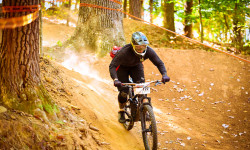
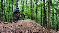
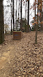
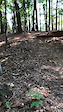
Photos of Roswell Mountain Bike
Videos of Roswell Mountain Bike
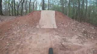
trail: Typhoon
0:13 |
105 |
May 24, 2025

trail: Typhoon
0:24 |
103 |
Nov 28, 2024
trail: El Scorcho
0:27 |
246 |
Apr 29, 2021
trail: El Scorcho
0:15 |
143 |
Apr 29, 2021

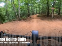
trail: Hurt's So Good
0:58 |
825 |
Apr 4, 2018
25:40 |
212 |
Jun 11, 2023
trail: Hollywood
0:53 |
601 |
Apr 5, 2023 , Roswell
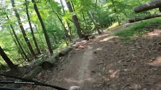
trail: Gully
0:05 |
462 |
Jun 5, 2021 , Roswell
Current Trail Warnings
| status | trail | date | condition | user | info |
|---|---|---|---|---|---|
| Skillet Express | May 28, 2026 @ 10:56am (America/New_York) May 28, 2026 | Unknown | lonniemilligan RAMBO | another tree |
Recent Trail Reports
Activity Feed
| username | action | type | title | date |
|---|---|---|---|---|
| lonniemilligan | add | poi | activity #97200478 | Jun 17, 2026 @ 11:52am Jun 17, 2026 |
| AllMtLemmon | add | photo | activity #96496244 and 1 more | Jun 7, 2026 @ 2:06pm Jun 7, 2026 |
| MelissaxNbW3 | wishlist | region | activity #96454300 | Jun 7, 2026 @ 6:31am Jun 7, 2026 |
| nateolmsted | vote | trail | activity #96417560 and 1 more | Jun 6, 2026 @ 5:13pm Jun 6, 2026 |
| Jamauller | wishlist | region | activity #96310431 | Jun 5, 2026 @ 11:22am Jun 5, 2026 |
Recent Comments
| username | type | title | comment | date |
|---|---|---|---|---|
| report | Dead tree in between Hollywood and Hawkeye... | May 29, 2026 @ 7:48am May 29, 2026 | ||
| trail | We've added a lot since this report. Aiming... | Apr 28, 2026 @ 7:07am Apr 28, 2026 | ||
| trail | Lots of technical stuff. Its fun for a... | Aug 13, 2025 @ 2:18am Aug 13, 2025 | ||
| trail | Fun trail. A little bit steep and a little bit... | Apr 23, 2024 @ 9:24am Apr 23, 2024 | ||
| trail | Beware. The main map shows 7 miles of blue... | Feb 17, 2024 @ 5:03pm Feb 17, 2024 |
Local Badges
-

Completionist15 awarded -

Epic Mountain Bike Climb 2k3 awarded -

Climbing 10k Badge65 awarded -

Mountain Biking 100k Badge2 awarded -

Epic Ride Descent 2k3 awarded -

Descent 10k Badge66 awarded
Bike & Skill Parks
| name | type | city | rating |
|---|---|---|---|
| Pumptrack | skill park | Roswell | |
| Skills Kitchen | skill park | Roswell |
Local Mountain Biking Directory
-
Roswell Alpharetta MTB Organization
![Roswell Alpharetta MTB Organization]()
-
Fresh Bike Service, IncBike Shop
-
Roswell BicyclesBike Shop
-
Atlanta CyclingBike Shop
![Atlanta Cycling]()
Activity Type Stats
| activitytype | trails | distance | descent | descent distance | total vertical | rating | global rank | state rank | photos | reports | routes | ridelogs |
|---|---|---|---|---|---|---|---|---|---|---|---|---|
| Mountain Bike | 44 | 15 miles | 1,883 ft | 6 miles | 240 ft | #493 | #182 | 52 | 680 | 2 | 25,067 | |
| E-Bike | 4 | 1 mile | 112 ft | 2,310 ft | 79 ft | 1 | 629 | 1 | 1,729 | |||
| Gravel Bike | 11 | 5 miles | 89 ft | 1 mile | 200 ft | #499 | #271 | 55 | 58 | |||
| Adaptive Bike | 11 | 5 miles | 89 ft | 1 mile | 200 ft | #456 | #1,788 | 48 | ||||
| Hike | 56 | 22 miles | 1,706 ft | 8 miles | 259 ft | #1,327 | #605 | 672 | 911 | |||
| Trail Running | 55 | 22 miles | 1,706 ft | 8 miles | 259 ft | #4,786 | #1,489 | 672 | 730 |
Frequently Asked Questions About Roswell
▼
What are the best places to ride in Roswell?
Roswell has 3 areas to explore for mountain biking. The top rated areas are:
▼
What are the highest rated mountain biking trails in Roswell?
The highest rated mountain biking trails in Roswell are:
- Lunch Line (4.4/5)
- Skillet Express (4.3/5)
- Troll Trail (4.2/5)
- Advanced Jump Line (4.2/5)
- Slalom (4.2/5)
▼
What is the best time of the year to ride in Roswell?
Based on ride log data, the most popular months to ride in Roswell are:
- July (180 activities)
- October (111 activities)
- November (100 activities)
▼
Where can I park to ride in Roswell?
There are 4 parking locations listed in Roswell. The most popular parking spots are: View all parking and trailhead locations on the map to plan your visit.
Activities
Trails
- By str8dwn
 & contributors
 - Admins: RAMBO, NGMBA
- #3341 - 7,340 views
- roswell activity log | embed map of Roswell mountain bike trails | roswell mountain biking points of interest polygons
Downloading of trail gps tracks in kml & gpx formats is enabled for Roswell.
You must login to download files.