close
-
Layers w
- Weather Layers
- Pro
- Pro
- Pro
- Pro
- Pro
- Pro
- More Layers
- Pro
- Pro
- Pro
- Pro
-
Upgrade to

3D
Trail Conditions
- Unknown
- Snow Groomed
- Snow Packed
- Snow Covered
- Snow Cover Partial
- Freeze/thaw Cycle
- Icy
- Prevalent Mud
- Wet
- Variable
- Ideal
- Dry
- Very Dry
Trail Flow (Ridden Direction)
Trailforks scans users ridelogs to determine the most popular direction each trail is ridden. A good flowing trail network will have most trails flowing in a single direction according to their intension.
The colour categories are based on what percentage of riders are riding a trail in its intended direction.
The colour categories are based on what percentage of riders are riding a trail in its intended direction.
- > 96%
- > 90%
- > 80%
- > 70%
- > 50%
- < 50%
- bi-directional trail
- no data
Trail Last Ridden
Trailforks scans ridelogs to determine the last time a trail was ridden.
- < 2 days
- < 1 week
- < 2 weeks
- < 1 month
- < 6 months
- > 6 months
Trail Ridden Direction
The intended direction a trail should be ridden.
- Downhill Only
- Downhill Primary
- Both Directions
- Uphill Primary
- Uphill Only
- One Direction
Contribute Details
Colors indicate trail is missing specified detail.
- Description
- Photos
- Description & Photos
- Videos
Trail Popularity ?
Trailforks scans ridelogs to determine which trails are ridden the most in the last 9 months.
Trails are compared with nearby trails in the same city region with a possible 25 colour shades.
Think of this as a heatmap, more rides = more kinetic energy = warmer colors.
- most popular
- popular
- less popular
- not popular
ATV/ORV/OHV Filter
Max Vehicle Width
inches
US Cell Coverage
Legend

Radar Time
Activity Recordings
Trailforks uses anonymized public activity data.
?
Activity Recordings
Trailforks uses anonymized public activity data.
?
Personal Heatmap
▶
Activity Types
all
/
none
▶
Options
2
Date range
month
–
Winter Trails
Warning
A routing network for winter maps does not exist. Selecting trails using the winter trails layer has been disabled.
Missing Trails
Most Popular
Least Popular
Trails are colored based on popularity. The more popular a trail is, the more red. Less popular trails trend towards green.
Jump Magnitude Heatmap
Heatmap of where riders jump on trails. Zoom in to see individual jumps, click circles to view jump details.
BC Backroad Status
![map legend]()
Service Road Atlas is a free to use, community-driven service for viewing and creating reports on the numerous back-country service roads around B.C. and Alberta.

Slope Aspect
Direction the slope faces
Trails Deemphasized
Trails are shown in grey.
Only show trails with no bike usage.
Suggested Layers
Based on selected activity type
Save the current map location and zoom level as your default home location whenever this page is loaded.
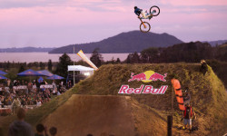
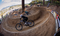
SaveThe Worlds Best Trails? It's a bold claim.
However, the thousands of locals and visitors who ride the Rotorua and Whakarewarewa trail network every year will all tell you they are a fantastic place to mountain bike.
In a country with some great mountain biking, this 220-kilometre trail network on the southern outskirts of the city are some of the finest. And research confirms the significant role they play in the lifestyle and economy of Rotorua with millions of dollars flowing in every year. The trails have evolved over the years with a lot of people involved in building, maintaining and developing them.
-Ride Rotorua
source: Ride Rotorua
Links
Activities Click to view
- Mountain Bike
328 trails
- E-Bike
321 trails
- Gravel Bike
1 trails
- Adaptive Bike
1 trails
- Winter Fat Bike
0 trails
- Horse
77 trails
- Hike
187 trails
- Trail Running
189 trails
Region Details
- 72
- 14
- 67
- 73
- 20
- 32
- 14
Region Status
Open as of 1 dayLocal Trail Association
Stats
- Avg Trail Rating
- Trails (view details)
- 359
- Trails Mountain Bike
- 331
- Trails E-Bike
- 321
- Trails Gravel Bike
- 1
- Trails Adaptive Bike
- 1
- Trails Horse
- 77
- Trails Hike
- 187
- Trails Trail Running
- 189
- Total Distance
- 286 miles
- Total Descent
- 62,281 ft
- Total Vertical
- 1,687 ft
- Highest Trailhead
- 2,525 ft
- Reports
- 19,469
- Photos
- 9,446
- Ridden Counter
- 459,534
Articles

Video: Crankworx Unfiltered Episode 4 Goes Deep in Rotorua
Apr 13, 2026 from pinkbike.com
Go inside the eleventh edition of Rotorua to see what life is actually like for Slopestyle pros between the tape, featuring backyard sessions and...

Video: Nicholi Rogatkin Recaps Crankworx Rotorua
Apr 7, 2026 from pinkbike.com
From Chance Moore’s history-making run to the "Cleanest Rider of the Week," Episode 2 of After the Run delivers the definitive slopestyle...
Matilda Melton and Chase Riggs Signal a Changing of the Guard in Rotorua
Mar 11, 2026 from pinkbike.com
On a day defined by veteran speed, the next generation stole the show with Melton taking an Elite Air DH podium and Riggs landing silver in his...
Everything You Need To Know Ahead of Crankworx Rotorua 2026
Mar 10, 2026 from pinkbike.com
Marking 10 years since the passing of Kelly McGarry, the world’s best return to Rotorua’s legendary course for the second stop of the...
Sub Regions
-
Okere Falls Scenic Reserve
-
Rainbow Mountain
- 1
-
Skyline - Rotorua
- 1
- 4
- 5
- 5
-
Te Ara Ahi
- 3
- 3
-
Whakarewarewa Forest
- 9
- 57
- 66
- 18
- 21
- 8
Popular Rotorua Mountain Biking Trails
• 100 ★ 4.1 • 1 mile • 43 ft • 4,193 •
In 2010/11 there was a major amount of harvesting in the area and the Rotorua Mountain Bike Club took the opportunity for a full rebuild. Part of the brief was to retain the shape and length of the original and in this the Club, along...
• 100 ★ 4.0 • 778 ft • 18 ft • 4,053 •
Highly rated popular green difficulty family friendly singletrack. This mountain bike primary trail and has a easy overall physical rating with a 18 ft green climb. On average it takes 1 minutes to complete this trail.
Ball and Chain Permanently Closed
• 95 ★ 3.4 • 2,100 ft • 26 ft • 3,447 •
A flat link trail that lets riders get between Nursery Rd. and the 8 Mile Gate entry to the forest without riding on the road or car park at the trailhead. The trail is two-way and it splits in places to allow for better flow, stay...
• 95 ★ 4.4 • 2,618 ft • 33 ft • 3,329 •
Fast, flowing machine built trail with jumps and table tops and bermed where you can pick up a lot of speed. Tends to get a bit rutted with lots of use and quite dusty in summer but rarely gets muddy so a good track to ride in the rain.
• 95 ★ 4.3 • 5,253 ft • 192 ft • 3,312 •
Previously known as A Trail, the name changed in June 2013 to Paddy's Run to commemorate Patrick 'Paddy' Avery, a fine young man and a very talented cyclist who passed away late in 2012. A fast, flowing trail showcasing Murray's...
• 95 ★ 3.6 • 1 mile • 0 ft • 3,301 •
ALL RIDERS MUST RIDE THIS TRAIL AND STAY OFF THE ROAD.
• 90 ★ 4.4 • 3,907 ft • 37 ft • 3,236 •
The Club’s brief for the extensive rebuild of the trail was to retain the shape, length and the style of the original as much as possible. While following the original line it now features a lot more berms, rollers and jumps (all...
• 100 ★ 4.0 • 1,066 ft • 0 ft • 3,144 •
Short flowy trail from end of Challenge ( ) to end of . Upper Link starts part way along this.
Rotorua Mountain Bike Routes
★ 3.7 • 22 miles • 3,487 ft • 4 • Loop •
The new Whakarewarewa Forest Loop is a 33km one-way route around the forest. The ride runs clockwise...
★ 4.0 • 18 miles • 3,050 ft • 42 • Loop •
A good intermediate - upper intermediate loop. A couple of good solid climbs but you will always be...
★ 5.0 • 16 miles • 2,488 ft • 14 • Loop •
Pick of the Whakarewarewa intermediate trails for a nice 25km loop
★ 4.0 • 17 miles • 2,894 ft • 29 • Loop •
Not sure what trails to ride in Whakarewarea Forest. Well these are a solid set of trails that offer...
★ 5.0 • 9 miles • 1,398 ft • 20 • Loop •
Yet another incredible ride in the Whakarewarewa Forest. This ride can be ridden as a cross country route...
★ 4.0 • 23 miles • 2,980 ft • 16 • Loop •
Loop from Tikitapu Blue Lake around Whaka Forest. Most of the ride is grade 2 and 3 mtb single track with...
Photos of Rotorua Mountain Bike
Videos of Rotorua Mountain Bike
0:20 |
13 |
Sep 3, 2025
0:13 |
7 |
Sep 3, 2025
trail: Maiden Voyage
0:12 |
|
Dec 2, 2024

trail: Rosebank
2:27 |
230 |
Nov 4, 2023

trail: Te Kōtukutuku
0:41 |
|
Oct 4, 2023

trail: Te Poaka
6:16 |
|
Jan 21, 2023
trail: Lower Sprint Warrior
0:07 |
47 |
Oct 22, 2022
trail: Tūteata
0:07 |
247 |
Apr 20, 2022
Recent Trail Reports
| status | trail | date | condition | info | user |
|---|---|---|---|---|---|
| Gunna Gotta | Jun 22, 2026 @ 7:05am (Pacific/Auckland) 2 days | Variable | MarkWestBike | ||
| Corners - Radius of the Lost Arcs | Jun 21, 2026 @ 7:32pm (Pacific/Auckland) 2 days | Dry | evilroyslade RTT | ||
| Challenge Roadside | Jun 20, 2026 @ 6:46pm (Pacific/Auckland) Jun 19, 2026 | Ideal | AjPWgZwp | ||
| Kung Fu Walrus | Jun 20, 2026 @ 11:11am (Pacific/Auckland) Jun 19, 2026 | Variable | scottcycles | ||
| Corridor rebuild | Jun 19, 2026 @ 5:51pm (Pacific/Auckland) Jun 18, 2026 | Unknown | Stewartfamily | ||
| Rainbow Mountain Summit Track | Jun 18, 2026 @ 1:33pm (Pacific/Auckland) Jun 17, 2026 | Unknown | windboy | ||
| Waipa Bypass Road | Jun 17, 2026 @ 12:55pm (Pacific/Auckland) Jun 16, 2026 | Ideal | windboy | ||
| No Brains | Jun 15, 2026 @ 8:47am (Pacific/Auckland) Jun 14, 2026 | Unknown | tonyoftheforest RTT | ||
| Tim Tams | Jun 14, 2026 @ 9:06pm (Pacific/Auckland) Jun 14, 2026 | Dry | evilroyslade RTT | ||
| Box of Birds + Fluffy Duck lines | Jun 13, 2026 @ 2:24pm (Pacific/Auckland) Jun 12, 2026 | Ideal | scottcycles |
Activity Feed
| username | action | type | title | date |
|---|---|---|---|---|
| KristensSssdB | wishlist | route | activity #97614561 | Jun 23, 2026 @ 3:06am 3 hours |
| HugeTrails97 | wishlist | trail | activity #97614304 and 20 more | Jun 23, 2026 @ 2:57am 3 hours |
| nickschryvers | ridden | trail | activity #97606921 | Jun 22, 2026 @ 10:59pm 7 hours |
| Rcobb | wishlist | route | activity #97571591 | Jun 22, 2026 @ 10:38am 19 hours |
| MarkWestBike | add | report | activity #97535279 | Jun 21, 2026 @ 6:02pm 1 day |
Recent Comments
| username | type | title | comment | date |
|---|---|---|---|---|
| report | Absolutely outstanding work. Better than when... | Jun 14, 2026 @ 9:32pm Jun 14, 2026 | ||
| report | Similar to the one noted on 2 June. | Jun 8, 2026 @ 7:52pm Jun 8, 2026 | ||
| report | Trees all sorted, sorry First Respond, just... | Jun 6, 2026 @ 10:25pm Jun 6, 2026 | ||
| report | Second location on the trail also cleared | Jun 6, 2026 @ 8:17pm Jun 6, 2026 | ||
| report | TV M. Nl lo. M. InMvm | Jun 3, 2026 @ 6:39pm Jun 3, 2026 |
Local Badges
-

Epic Ride Climb 2k3,427 awarded -

Climbing 10k Badge1,149 awarded -

Climbing 100k Badge116 awarded -

Epic Ride Descent 2k4,490 awarded -

Descent 10k Badge1,225 awarded -

Descent 100k Badge121 awarded
Bike & Skill Parks
| name | type | city | rating |
|---|---|---|---|
| Skyline - Rotorua | bike park | Rotorua | |
| Dodzy Skills Park | skill park | Rotorua | |
| Rotorua BMX Track | skill park | Rotorua | |
| Te Papa o Te Kauri BMX Track | skill park | Rotorua | |
| Wattles Dual Slalom Course | skill park | Rotorua |
Upcoming Local Events
Activity Type Stats
| activitytype | trails | distance | descent | descent distance | total vertical | rating | global rank | state rank | photos | reports | routes | ridelogs |
|---|---|---|---|---|---|---|---|---|---|---|---|---|
| Mountain Bike | 328 | 247 miles | 55,427 ft | 125 miles | 1,601 ft | #14 | #1 | 8,652 | 19,096 | 286 | 153,675 | |
| E-Bike | 321 | 245 miles | 53,957 ft | 124 miles | 1,601 ft | #29 | #4 | 230 | 18,230 | 77 | 17,242 | |
| Gravel Bike | 1 | #86 | #52 | 177 | 2 | 370 | ||||||
| Adaptive Bike | 1 | #47 | #62 | 23 | 11 | |||||||
| Horse | 77 | 74 miles | 9,183 ft | 29 miles | 1,444 ft | #79 | #3 | 55 | 3,296 | 3 | 81 | |
| Hike | 187 | 184 miles | 22,470 ft | 75 miles | 1,657 ft | #199 | #6 | 266 | 13,021 | 8 | 2,909 | |
| Trail Running | 189 | 185 miles | 22,470 ft | 75 miles | 1,657 ft | #200 | #6 | 211 | 13,065 | 12 | 13,097 |
Frequently Asked Questions About Rotorua
▼
What are the best places to ride in Rotorua?
Rotorua has 9 areas to explore for mountain biking. The top rated areas are:
▼
What are the highest rated mountain biking trails in Rotorua?
The highest rated mountain biking trails in Rotorua are:
- Te Poaka (4.8/5)
- Tumeke (4.7/5)
- Tūteata (4.7/5)
- Yellow Brick Return (4.7/5)
- Te Ranga (Rainbow Mountain Trail) (4.7/5)
▼
What is the best time of the year to ride in Rotorua?
Based on ride log data, the most popular months to ride in Rotorua are:
- January (1,231 activities)
- October (948 activities)
- February (922 activities)
▼
Where can I park to ride in Rotorua?
There are 12 parking locations listed in Rotorua. The most popular parking spots are:
- Nursery Rd Car Park
- Waipa Road Parking
- Hill Road Parking
- Tawa Forest Hub Carpark - Te Pūtake o Tawa
- Te Puia Carpark
Activities
Trails
Points of Interest
- [falls] Okere Falls Other
- Bridge TTF
- [Rentals] Electric Bike Rotorua E-bike Rentals Other
- Beginner's Bypass Gully TTF
- Dipper Gully TTF
- [falls] Okere Falls Other
- [falls] Trout Pool Falls Other
- [falls] Okere Falls Other
- [falls] Tutea Falls Other
- [falls] Okere Falls Other
- Ruawahia Dome (1,102 m)
- Koa (1,018 m)
- Wahanga Dome (1,013 m)
- By outhouse
 & contributors
 - Admins: kyleMichel, RTT, caseyking, Mcorbett415, Cha1ky, KrisOD, rockroll, Rotorua-Trails-Trust
- #4050 - 292,348 views
- rotorua activity log | embed map of Rotorua mountain bike trails | rotorua mountain biking points of interest
Downloading of trail gps tracks in kml & gpx formats is enabled for Rotorua.
You must login to download files.