close
-
Layers w
- Weather Layers
- Pro
- Pro
- Pro
- Pro
- Pro
- Pro
- More Layers
- Pro
- Pro
- Pro
- Pro
-
Upgrade to

3D
Trail Conditions
- Unknown
- Snow Groomed
- Snow Packed
- Snow Covered
- Snow Cover Partial
- Freeze/thaw Cycle
- Icy
- Prevalent Mud
- Wet
- Variable
- Ideal
- Dry
- Very Dry
Trail Flow (Ridden Direction)
Trailforks scans users ridelogs to determine the most popular direction each trail is ridden. A good flowing trail network will have most trails flowing in a single direction according to their intension.
The colour categories are based on what percentage of riders are riding a trail in its intended direction.
The colour categories are based on what percentage of riders are riding a trail in its intended direction.
- > 96%
- > 90%
- > 80%
- > 70%
- > 50%
- < 50%
- bi-directional trail
- no data
Trail Last Ridden
Trailforks scans ridelogs to determine the last time a trail was ridden.
- < 2 days
- < 1 week
- < 2 weeks
- < 1 month
- < 6 months
- > 6 months
Trail Ridden Direction
The intended direction a trail should be ridden.
- Downhill Only
- Downhill Primary
- Both Directions
- Uphill Primary
- Uphill Only
- One Direction
Contribute Details
Colors indicate trail is missing specified detail.
- Description
- Photos
- Description & Photos
- Videos
Trail Popularity ?
Trailforks scans ridelogs to determine which trails are ridden the most in the last 9 months.
Trails are compared with nearby trails in the same city region with a possible 25 colour shades.
Think of this as a heatmap, more rides = more kinetic energy = warmer colors.
- most popular
- popular
- less popular
- not popular
ATV/ORV/OHV Filter
Max Vehicle Width
inches
US Cell Coverage
Legend

Radar Time
Activity Recordings
Trailforks uses anonymized public activity data.
?
Activity Recordings
Trailforks uses anonymized public activity data.
?
Personal Heatmap
▶
Activity Types
all
/
none
▶
Options
2
Date range
month
–
Winter Trails
Warning
A routing network for winter maps does not exist. Selecting trails using the winter trails layer has been disabled.
Missing Trails
Most Popular
Least Popular
Trails are colored based on popularity. The more popular a trail is, the more red. Less popular trails trend towards green.
Jump Magnitude Heatmap
Heatmap of where riders jump on trails. Zoom in to see individual jumps, click circles to view jump details.
BC Backroad Status
![map legend]()
Service Road Atlas is a free to use, community-driven service for viewing and creating reports on the numerous back-country service roads around B.C. and Alberta.

Slope Aspect
Direction the slope faces
Trails Deemphasized
Trails are shown in grey.
Only show trails with no bike usage.
Suggested Layers
Based on selected activity type
Save the current map location and zoom level as your default home location whenever this page is loaded.
Save
No description for Royal Gorge has been added yet!
Login or register to submit one.
 google parking directions
Primary Trail Type: Cross-Country
Land Status: National Forest
Land Manager: USFS - Truckee Ranger District
google parking directions Region Supporters & Maintainers
Activities Click to view
- Mountain Bike
47 trails
- E-Bike
47 trails
- Horse
52 trails
- Hike
53 trails
- Trail Running
53 trails
Region Details
- 6
- 15
- 20
- 6
Region Status
Caution as of Jun 17, 2026Stats
- Avg Trail Rating
- Trails (view details)
- 56
- Trails Mountain Bike
- 47
- Trails E-Bike
- 47
- Trails Horse
- 52
- Trails Hike
- 53
- Trails Trail Running
- 53
- Trails Backcountry Ski
- 3
- Trails Nordic Ski
- 1
- Total Distance
- 33 miles
- Total Descent
- 4,846 ft
- Total Vertical
- 889 ft
- Highest Trailhead
- 7,590 ft
- Reports
- 318
- Photos
- 127
- Ridden Counter
- 5,218
Popular Royal Gorge Mountain Biking Trails
• 90 ★ 4.3 • 4,524 ft • 204 ft • 410 •
Popular blue difficulty singletrack. This multi-use trail can be used both directions and has a moderate overall physical rating with a 204 ft blue climb. On average it takes 11 minutes to complete this trail.
• 90 ★ 4.0 • 1 mile • 252 ft • 373 •
Part of the new singletrack installed by the TD Land Trust a couple of years back. This one climbs gradually with a nice, long traverse to the western saddle on . Really well designed and built, the trail is plenty wide and swoops...
• 90 ★ 3.5 • 3,688 ft • 217 ft • 365 •
Popular blue difficulty singletrack. This multi-use trail can be used both directions and has a moderate overall physical rating with a 217 ft blue climb. On average it takes 8 minutes to complete this trail.
• 90 ★ 0.0 • 673 ft • 0 ft • 355 •
Popular blue difficulty singletrack. This multi-use trail can be used both directions. On average it takes minutes to complete this trail.
• 90 ★ 4.4 • 3,806 ft • 3 ft • 345 •
This section of trail is a non-technical, fun downhill with some well-built switchbacks. Can certainly be ridden in either direction, but it's steeper than the "Reroute" trail just to the east, so probably a better descent.
• 85 ★ 1.0 • 1,670 ft • 20 ft • 335 •
Popular green difficulty doubletrack. This multi-use trail can be used both directions and has a moderate overall physical rating with a 20 ft green climb. On average it takes 2 minutes to complete this trail.
• 95 ★ 4.0 • 1,165 ft • 71 ft • 319 •
Popular blue difficulty singletrack. This multi-use trail can be used both directions and has a moderate overall physical rating with a 71 ft blue climb. On average it takes 2 minutes to complete this trail.
• 80 ★ 4.0 • 2,274 ft • 0 ft • 294 •
Popular blue difficulty singletrack. This mountain bike primary trail can be used both directions and has a hard overall physical rating with a 0 ft blue climb. On average it takes 3 minutes to complete this trail.
Royal Gorge Mountain Bike Routes
7 miles • 974 ft • 7 • Loop •
A super fun route around some of the Serene Lakes trails with great views and some of the better descents.
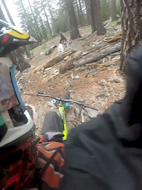
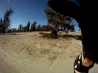
Photos of Royal Gorge Mountain Bike
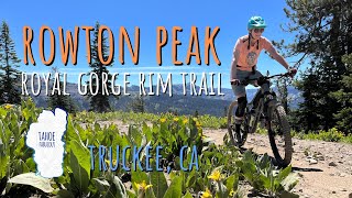
Videos of Royal Gorge Mountain Bike
trail: From the Top
0:57 |
123 |
Dec 31, 2014
trail: From the Top
3:04 |
283 |
Nov 10, 2013

12:10 |
192 |
Aug 13, 2023 , Truckee
12:10 |
131 |
Aug 13, 2023 , Truckee

12:10 |
142 |
Aug 13, 2023 , Truckee

trail: Razorback Reroute
10:45 |
427 |
Jul 31, 2020 , Truckee

6:26 |
384 |
Feb 22, 2020 , Truckee
Recent Trail Reports
Activity Feed
| username | action | type | title | date |
|---|---|---|---|---|
| mellokristen | wishlist | route | activity #97594324 | Jun 22, 2026 @ 5:28pm Jun 22, 2026 |
| bshefftz | add | report | activity #97205404 | Jun 17, 2026 @ 1:06pm Jun 17, 2026 |
| SosierJ371x | wishlist | trail | activity #96202756 | Jun 3, 2026 @ 8:05pm Jun 3, 2026 |
| Redhawk | add | report | activity #95898697 and 2 more | May 30, 2026 @ 5:10pm May 30, 2026 |
| Jmagik172 | add | report | activity #95524046 and 9 more | May 25, 2026 @ 2:31pm May 25, 2026 |
Recent Comments
| username | type | title | comment | date |
|---|---|---|---|---|
| trail | Sketch little section. Very narrow and rocky. | Oct 16, 2022 @ 7:13pm Oct 16, 2022 | ||
| report | Error | Jun 25, 2022 @ 8:58pm Jun 25, 2022 | ||
| trail | Super nice trail. Nice hairpins and great... | Sep 21, 2021 @ 9:32pm Sep 21, 2021 | ||
| trail | It's quite soft. Just needs a little traffic... | Aug 10, 2021 @ 7:21am Aug 10, 2021 | ||
| trail | I do this uphill on my ebike. Great way of... | Jul 31, 2021 @ 5:34pm Jul 31, 2021 |
Nearby Areas
| name | distance | ||||
|---|---|---|---|---|---|
| Sugar Bowl | 7 | 5 | 2.7 km | ||
| Summit Lakes | 1 | 2.7 km | |||
| North Fork American Headwaters | 1 | 1 | 2.8 km | ||
| Donner Summit | 4 | 5 | 2 | 3.1 km | |
| Boreal Mountain Resort | 4 | 1 | 1 | 3.4 km |
Local Badges
-

Completionist0 awarded
Activity Type Stats
| activitytype | trails | distance | descent | descent distance | total vertical | rating | global rank | state rank | photos | reports | routes | ridelogs |
|---|---|---|---|---|---|---|---|---|---|---|---|---|
| Mountain Bike | 47 | 26 miles | 3,720 ft | 12 miles | 889 ft | #5,301 | #1,919 | 115 | 316 | 2 | 1,350 | |
| E-Bike | 47 | 26 miles | 3,720 ft | 12 miles | 889 ft | #3,765 | #1,071 | 2 | 231 | 3 | 151 | |
| Horse | 52 | 31 miles | 4,314 ft | 14 miles | 889 ft | #1,251 | #639 | 113 | ||||
| Hike | 53 | 31 miles | 4,314 ft | 14 miles | 889 ft | #5,667 | #2,038 | 10 | 317 | 3 | 256 | |
| Trail Running | 53 | 31 miles | 4,314 ft | 14 miles | 889 ft | #4,915 | #1,456 | 317 | 3 | 218 | ||
| Backcountry Ski | 3 | 3,379 ft | 262 ft | 1,877 ft | 404 ft | 1 | 8 | |||||
| Nordic Ski | 1 | 2 miles | 269 ft | 2 miles | 269 ft | #507 | 1 | 57 |
Frequently Asked Questions About Royal Gorge
▼
What are the highest rated mountain biking trails in Royal Gorge?
The highest rated mountain biking trails in Royal Gorge are:
- Memorial Overland Emigrant Trail (4.2/5)
- Point Mariah (4.1/5)
- Royal Gorge Rim Trail: Bogus Basin to Razorback (4.1/5)
- Royal Gorge Rim Trail: Tiny Tim to Bogus Basin (4.1/5)
- Mariah Approach (4.1/5)
▼
Where can I park to ride in Royal Gorge?
There are 2 parking locations listed in Royal Gorge. The most popular parking spots are:
▼
What is the longest trail in Royal Gorge?
The longest trail in Royal Gorge is Memorial Overland Emigrant Trail at 2.7 miles. View all trails sorted by distance.
▼
What are the best & highest rated hiking trails in Royal Gorge?
The best hiking trails in Royal Gorge are:
- Rowton Peak Trail
- Switchback Connector I
- Upper Razorback
- Royal Gorge Rim Trail: Rowton Peak Spur
- Rowton Peak Trail
Activities
Trails
- By maddy03
 & contributors
 - Admins: BONC, TTF, TDLT, DPMR, elikat715, Redhawk, limbolizard, allisonbriney, BONC, TTF
- #56150 - 1,923 views
- royal gorge activity log | embed map of Royal Gorge mountain bike trails | royal gorge mountain biking points of interest
Downloading of trail gps tracks in kml & gpx formats is enabled for Royal Gorge.
You must login to download files.