close
-
Layers w
- Weather Layers
- Pro
- Pro
- Pro
- Pro
- Pro
- Pro
- More Layers
- Pro
- Pro
- Pro
- Pro
-
Upgrade to

3D
Trail Conditions
- Unknown
- Snow Groomed
- Snow Packed
- Snow Covered
- Snow Cover Partial
- Freeze/thaw Cycle
- Icy
- Prevalent Mud
- Wet
- Variable
- Ideal
- Dry
- Very Dry
Trail Flow (Ridden Direction)
Trailforks scans users ridelogs to determine the most popular direction each trail is ridden. A good flowing trail network will have most trails flowing in a single direction according to their intension.
The colour categories are based on what percentage of riders are riding a trail in its intended direction.
The colour categories are based on what percentage of riders are riding a trail in its intended direction.
- > 96%
- > 90%
- > 80%
- > 70%
- > 50%
- < 50%
- bi-directional trail
- no data
Trail Last Ridden
Trailforks scans ridelogs to determine the last time a trail was ridden.
- < 2 days
- < 1 week
- < 2 weeks
- < 1 month
- < 6 months
- > 6 months
Trail Ridden Direction
The intended direction a trail should be ridden.
- Downhill Only
- Downhill Primary
- Both Directions
- Uphill Primary
- Uphill Only
- One Direction
Contribute Details
Colors indicate trail is missing specified detail.
- Description
- Photos
- Description & Photos
- Videos
Trail Popularity ?
Trailforks scans ridelogs to determine which trails are ridden the most in the last 9 months.
Trails are compared with nearby trails in the same city region with a possible 25 colour shades.
Think of this as a heatmap, more rides = more kinetic energy = warmer colors.
- most popular
- popular
- less popular
- not popular
ATV/ORV/OHV Filter
Max Vehicle Width
inches
US Cell Coverage
Legend

Radar Time
Activity Recordings
Trailforks uses anonymized public activity data.
?
Activity Recordings
Trailforks uses anonymized public activity data.
?
Personal Heatmap
▶
Activity Types
all
/
none
▶
Options
2
Date range
month
–
Winter Trails
Warning
A routing network for winter maps does not exist. Selecting trails using the winter trails layer has been disabled.
Missing Trails
Most Popular
Least Popular
Trails are colored based on popularity. The more popular a trail is, the more red. Less popular trails trend towards green.
Jump Magnitude Heatmap
Heatmap of where riders jump on trails. Zoom in to see individual jumps, click circles to view jump details.
BC Backroad Status
![map legend]()
Service Road Atlas is a free to use, community-driven service for viewing and creating reports on the numerous back-country service roads around B.C. and Alberta.

Slope Aspect
Direction the slope faces
Trails Deemphasized
Trails are shown in grey.
Only show trails with no bike usage.
Suggested Layers
Based on selected activity type
Save the current map location and zoom level as your default home location whenever this page is loaded.
Save
No description for Rush Creek has been added yet!
Login or register to submit one.
 google parking directions
Primary Trail Type: Cross-Country
Land Status: County Park
Land Manager: Marin County Parks
google parking directionsLinks
Activities Click to view
- Mountain Bike
5 trails
- Horse
6 trails
- Hike
6 trails
- Trail Running
6 trails
Region Details
- 5
Region Status
Open as of Jul 5, 2025Stats
- Avg Trail Rating
- Trails (view details)
- 6
- Trails Mountain Bike
- 5
- Trails Horse
- 6
- Trails Hike
- 6
- Trails Trail Running
- 6
- Total Distance
- 8 miles
- Total Descent Distance
- 3 miles
- Total Descent
- 685 ft
- Total Vertical
- 268 ft
- Highest Trailhead
- 273 ft
- Reports
- 77
- Photos
- 13
- Ridden Counter
- 886
Popular Rush Creek Mountain Biking Trails
• 90 ★ 4.0 • 3 miles • 147 ft • 214 •
Popular green difficulty mixed. This multi-use trail can be used both directions and has a easy overall physical rating with a 147 ft green climb. Trail visibility is always easy to follow. On average it takes 17 minutes to complete this trail.
• 75 ★ 3.0 • 2,287 ft • 0 ft • 99 •
Popular green difficulty singletrack. This mountain bike primary trail can be used both directions. On average it takes 2 minutes to complete this trail.
• 80 ★ 0.0 • 2,730 ft • 0 ft • 76 •
Popular green difficulty singletrack. This mountain bike primary trail can be used downhill only. On average it takes 2 minutes to complete this trail.
Rush Creek Mountain Bike Routes
★ 5.0 • 9 miles • 600 ft • 5 • Loop •
Trail 47.3% Access (fire road) 50.0% Street 2.7% Total distance - 9 miles (R/T) Distance and riding time...
Photos of Rush Creek Mountain Bike
Videos of Rush Creek Mountain Bike
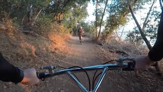
3:54 |
659 |
Sep 23, 2020 , Novato
Recent Trail Reports
| status | trail | date | condition | info | user |
|---|---|---|---|---|---|
| Lucky Aces | Jul 5, 2025 @ 6:01pm Jul 5, 2025 | Very Dry | jacobrian | ||
| Bahia Ridge Fire Road | Jul 5, 2025 @ 6:01pm Jul 5, 2025 | Very Dry | jacobrian | ||
| Rush Creek-Bahia Rd Trailhead to Bridge | Jul 5, 2025 @ 6:01pm Jul 5, 2025 | Very Dry | jacobrian | ||
| Blue Oak | Jul 5, 2025 @ 6:01pm Jul 5, 2025 | Very Dry | jacobrian | ||
| Pinheiro Fire Road | Jun 30, 2024 @ 1:26am Jun 30, 2024 | Very Dry | tamarancho-report EMBA-Staff |
Activity Feed
| username | action | type | title | date |
|---|---|---|---|---|
| ffmill | wishlist | region | activity #96583095 | Jun 8, 2026 @ 8:31pm Jun 8, 2026 |
| ffmill | wishlist | region | activity #96340553 | Jun 5, 2026 @ 8:36pm Jun 5, 2026 |
| tinak | vote | route | activity #93221934 | Apr 23, 2026 @ 9:59am Apr 23, 2026 |
| Alonsoafan | wishlist | region | activity #85101807 | Dec 3, 2025 @ 8:04am Dec 3, 2025 |
| mlyamamoto | wishlist | route | activity #83577645 | Nov 4, 2025 @ 12:16pm Nov 4, 2025 |
Recent Comments
| username | type | title | comment | date |
|---|---|---|---|---|
| trail | Cool little downhill singletrack. Good for... | Nov 1, 2022 @ 12:00pm Nov 1, 2022 | ||
| trail | Fun, mostly single track with some fire road.... | Sep 14, 2018 @ 11:20pm Sep 14, 2018 |
Nearby Areas
| name | distance | ||||
|---|---|---|---|---|---|
| Mount Burdell | 14 | 2 | 1 | 2 km | |
| Olompali State Historic Park | 1 | 1 | 2.1 km | ||
| Indian Tree Preserve | 2 | 4.4 km | |||
| Lucas, Ignacio, Loma Verde, Pacheco and Marinwood Open Space | 9 | 7 | 3 | 5.3 km | |
| Stafford Lake Bike Park | 6 | 1 | 5.4 km |
Local Products
Activity Type Stats
| activitytype | trails | distance | descent | descent distance | total vertical | rating | global rank | state rank | photos | reports | routes | ridelogs |
|---|---|---|---|---|---|---|---|---|---|---|---|---|
| Mountain Bike | 5 | 7 miles | 518 ft | 3 miles | 226 ft | #8,788 | #3,440 | 13 | 76 | 1 | 2,655 | |
| Horse | 6 | 8 miles | 686 ft | 3 miles | 269 ft | #3,020 | #1,748 | 5 | ||||
| Hike | 6 | 8 miles | 686 ft | 3 miles | 269 ft | #15,053 | #6,704 | 77 | 131 | |||
| Trail Running | 6 | 8 miles | 686 ft | 3 miles | 269 ft | #13,772 | #5,760 | 77 | 148 |
Frequently Asked Questions About Rush Creek
▼
What are the highest rated mountain biking trails in Rush Creek?
The highest rated mountain biking trails in Rush Creek are:
- Blue Oak (4/5)
- Rush Creek-Bahia Rd Trailhead to Bridge (4/5)
- Lucky Aces (0/5)
▼
What is the best time of the year to ride in Rush Creek?
Based on ride log data, the most popular months to ride in Rush Creek are:
- July (58 activities)
- May (21 activities)
- April (18 activities)
▼
Where can I park to ride in Rush Creek?
There are 1 parking locations listed in Rush Creek. The most popular parking spots are:
▼
What is the longest trail in Rush Creek?
The longest trail in Rush Creek is Rush Creek-Bahia Rd Trailhead to Bridge at 3.0 miles. View all trails sorted by distance.
- By jzdyrko & contributors
- Admins: A4B, A4B
- #20896 - 4,363 views
- rush creek activity log | embed map of Rush Creek mountain bike trails | rush creek mountain biking points of interest polygons
Downloading of trail gps tracks in kml & gpx formats is enabled for Rush Creek.
You must login to download files.