close
-
Layers w
- Weather Layers
- Pro
- Pro
- Pro
- Pro
- Pro
- Pro
- More Layers
- Pro
- Pro
- Pro
- Pro
-
Upgrade to

3D
Trail Conditions
- Unknown
- Snow Groomed
- Snow Packed
- Snow Covered
- Snow Cover Partial
- Freeze/thaw Cycle
- Icy
- Prevalent Mud
- Wet
- Variable
- Ideal
- Dry
- Very Dry
Trail Flow (Ridden Direction)
Trailforks scans users ridelogs to determine the most popular direction each trail is ridden. A good flowing trail network will have most trails flowing in a single direction according to their intension.
The colour categories are based on what percentage of riders are riding a trail in its intended direction.
The colour categories are based on what percentage of riders are riding a trail in its intended direction.
- > 96%
- > 90%
- > 80%
- > 70%
- > 50%
- < 50%
- bi-directional trail
- no data
Trail Last Ridden
Trailforks scans ridelogs to determine the last time a trail was ridden.
- < 2 days
- < 1 week
- < 2 weeks
- < 1 month
- < 6 months
- > 6 months
Trail Ridden Direction
The intended direction a trail should be ridden.
- Downhill Only
- Downhill Primary
- Both Directions
- Uphill Primary
- Uphill Only
- One Direction
Contribute Details
Colors indicate trail is missing specified detail.
- Description
- Photos
- Description & Photos
- Videos
Trail Popularity ?
Trailforks scans ridelogs to determine which trails are ridden the most in the last 9 months.
Trails are compared with nearby trails in the same city region with a possible 25 colour shades.
Think of this as a heatmap, more rides = more kinetic energy = warmer colors.
- most popular
- popular
- less popular
- not popular
ATV/ORV/OHV Filter
Max Vehicle Width
inches
US Cell Coverage
Legend

Radar Time
Activity Recordings
Trailforks uses anonymized public activity data.
?
Activity Recordings
Trailforks uses anonymized public activity data.
?
Personal Heatmap
▶
Activity Types
all
/
none
▶
Options
2
Date range
month
–
Winter Trails
Warning
A routing network for winter maps does not exist. Selecting trails using the winter trails layer has been disabled.
Missing Trails
Most Popular
Least Popular
Trails are colored based on popularity. The more popular a trail is, the more red. Less popular trails trend towards green.
Jump Magnitude Heatmap
Heatmap of where riders jump on trails. Zoom in to see individual jumps, click circles to view jump details.
BC Backroad Status
![map legend]()
Service Road Atlas is a free to use, community-driven service for viewing and creating reports on the numerous back-country service roads around B.C. and Alberta.

Slope Aspect
Direction the slope faces
Trails Deemphasized
Trails are shown in grey.
Only show trails with no bike usage.
Suggested Layers
Based on selected activity type
Save the current map location and zoom level as your default home location whenever this page is loaded.
SaveSnowshoe Description:
Le Club de ski de fond Les Trappeurs tient à vous souhaiter la bienvenue dans ses magnifiques sentiers.
Mario Baillargeon et Louis-Marie Babin, responsables des sentiers de raquette.
Venez profiter de nos 18 kilomètres de sentiers de raquette.
Afin de vous donner un aperçu, n’hésitez pas à consulter la carte des sentiers de raquette de Saint-Côme.
View region descriptions for other activity types
Le Club de ski de fond Les Trappeurs tient à vous souhaiter la bienvenue dans ses magnifiques sentiers.
Mario Baillargeon et Louis-Marie Babin, responsables des sentiers de raquette.
Venez profiter de nos 18 kilomètres de sentiers de raquette.
Afin de vous donner un aperçu, n’hésitez pas à consulter la carte des sentiers de raquette de Saint-Côme.
Snowshoe
Le Club de ski de fond Les Trappeurs tient à vous souhaiter la bienvenue dans ses magnifiques sentiers. Mario Baillargeon et Louis-Marie Babin, responsables des sentiers de raquette.
Venez profiter de nos 18 kilomètres de sentiers de raquette.
Afin de vous donner un aperçu, n’hésitez pas à consulter la carte des sentiers de raquette de Saint-Côme.
Nordic Ski
Le Club de ski de fond Les Trappeurs tient à vous souhaiter la bienvenue dans ses magnifiques sentiers. Notre SUPER MERCI va aux propriétaires de terrains qui rendent le tout possible depuis toutes ces années. Un site enchanteur qui nous est offert gratuitement en plein cœur de Saint-Côme, c’est simplement un gros WOWAlain Bordeleau, président et secrétaire-trésorier;
Pamela Vallière, secrétaire et responsable des activités;
Daniel Boudreau et Patrice Perrot, responsables des sentiers de ski de fond;
Nous invitons toutes personnes qui désirent faire partie de l’équipe de bénévoles à communiquer avec Alain Bordeleau au 450 883-8477.
Venez profiter de nos 11.5 km de sentiers de ski de fond.
Afin de vous donner un aperçu, n’hésitez pas à consulter la carte des sentiers de raquette et des sentiers de ski de fond de Saint-Côme.
NOUVEAU : Le Camp Richelieu fait maintenant la location de ski de fond. Communiquez avec le 450 883-6446 afin de vérifier la disponibilité
Bon hiver !
Contact
Vieux presbytère
1661-A, rue Principale
Saint-Côme (Québec)
CANADA J0K 2B0
Téléphone: 450 883-2730
AKA: St-Come
Links
Activities Click to view
- Mountain Bike
68 trails
- E-Bike
21 trails
- Adaptive Bike
0 trails
- Winter Fat Bike
1 trails
- Hike
86 trails
- Trail Running
87 trails
- Snowshoe
66 trails
- Downhill Ski
32 trails
- Nordic Ski
15 trails
Region Details
- 21
- 21
- 17
- 2
- 1
Region Status
Open as of 12 hoursStats
- Avg Trail Rating
- Trails (view details)
- 159
- Trails Mountain Bike
- 68
- Trails E-Bike
- 21
- Trails Winter Fat Bike
- 1
- Trails Hike
- 86
- Trails Trail Running
- 87
- Trails Snowshoe
- 66
- Trails Downhill Ski
- 32
- Trails Backcountry Ski
- 2
- Trails Nordic Ski
- 15
- Total Distance
- 110 miles
- Total Descent
- 25,104 ft
- Total Vertical
- 1,304 ft
- Highest Trailhead
- 2,091 ft
- Reports
- 682
- Photos
- 133
- Ridden Counter
- 9,751
Sub Regions
-
Parc Louis-Philippe-De Grandpré
- 17
- 11
- 2
- 1
-
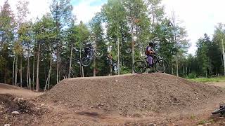
Val Saint Côme
- 3
- 4
- 7
- 1
- 1
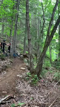
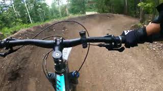
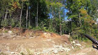
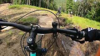
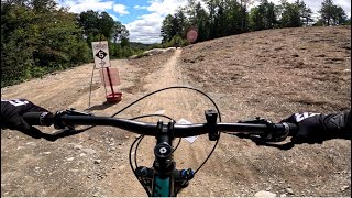
Popular Saint-Côme Mountain Biking Trails
• 100 ★ 2.0 • 604 ft • 10 ft • 345 •
Singletrack de type crosscountry principalement utiliser comme échangeur
• 100 ★ 4.7 • 1,329 ft • 17 ft • 317 •
Piste de type enduro avec un bon flow. Magnifique passerelle en bois. Quelques sauts optionnels. Refonte prévue en 2026. Svp respecter la signalisation pendant les travaux.
• 90 ★ 3.0 • 1,175 ft • 34 ft • 308 •
Piste intermédiaire de type cross-country. Étroite avec beaucoup de roches. Quelques fois moins appréciée par les intermédiaires en raison des pédales qui accrochent dans les roches. Technique!
• 80 ★ 4.0 • 4,501 ft • 22 ft • 293 •
Piste facile de type cross-country. Préférable à pour les débutants ou en fin de sortie pour naviguer entre les deux secteurs "enduro"
• 80 ★ 4.0 • 4,705 ft • 0 ft • 291 •
Piste intermédiaire de type cross-country avec quelques sections flowy. Roches et racines présentes. Quelques beaux points de vue sur la rivière l'assomption.
• 90 ★ 0.0 • 659 ft • 15 ft • 290 •
Alternative à pour une montée moins technique. Descente également possible. Type cross-country avec peu de roches et racines
• 95 ★ 3.0 • 709 ft • 26 ft • 286 •
Piste intermédiaire de type cross-country. Principalement un accès au reste du réseau
Saint-Côme Mountain Bike Routes
5 miles • 323 ft • 13 •
Belle route intermédiaire pour s'initier aux pistes flowys. Calculer entre 1h et 2 h pour parcourir...
3 miles • 137 ft • 4 •
Boucle d'initiation de vélo de montagne. Idéal pour les débutants. Devrait prendre autour de 1h et...
Photos of Saint-Côme Mountain Bike
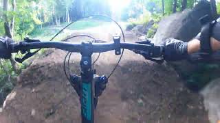
Videos of Saint-Côme Mountain Bike
trail: Sentence
0:11 |
254 |
Jul 21, 2020
trail: Afterbang
0:19 |
129 |
Apr 11, 2025 , Saint-Côme
trail: Sonic
3:21 |
206 |
Apr 11, 2025 , Saint-Côme
trail: Top Gun
0:13 |
115 |
Apr 11, 2025 , Saint-Côme
trail: Top Gun
3:02 |
100 |
Apr 11, 2025 , Saint-Côme
trail: Top Gun
0:06 |
128 |
Apr 11, 2025 , Saint-Côme
trail: Totem
4:30 |
94 |
Apr 11, 2025 , Saint-Côme
trail: Évasion
0:56 |
172 |
Apr 11, 2025 , Saint-Côme
Current Trail Warnings
| status | trail | date | condition | user | info |
|---|---|---|---|---|---|
| Vol Qualifié | Jun 2, 2026 @ 1:28pm (America/Toronto) Jun 2, 2026 | Unknown | sven41 | travaux en cours | |
| Comparution-1 | Jun 2, 2026 @ 1:28pm (America/Toronto) Jun 2, 2026 | Unknown | sven41 | Travaux en cours |
Recent Trail Reports
| status | trail | date | condition | info | user |
|---|---|---|---|---|---|
| Vice Caché | Jun 19, 2026 @ 3:53pm (America/Toronto) 12 hours | Variable | sven41 | ||
| Usufruit option drop | Jun 19, 2026 @ 3:53pm (America/Toronto) 12 hours | Variable | sven41 | ||
| Usufruit boucle rock face et pont | Jun 19, 2026 @ 3:53pm (America/Toronto) 12 hours | Variable | sven41 | ||
| Usufruit | Jun 19, 2026 @ 3:53pm (America/Toronto) 12 hours | Variable | sven41 | ||
| Travaux Forcés | Jun 19, 2026 @ 3:53pm (America/Toronto) 12 hours | Variable | sven41 | ||
| Stagiaire | Jun 19, 2026 @ 3:53pm (America/Toronto) 12 hours | Variable | sven41 | ||
| Serment | Jun 19, 2026 @ 3:53pm (America/Toronto) 12 hours | Variable | sven41 | ||
| Sentence | Jun 19, 2026 @ 3:53pm (America/Toronto) 12 hours | Variable | sven41 | ||
| Réquisition | Jun 19, 2026 @ 3:53pm (America/Toronto) 12 hours | Variable | sven41 | ||
| Récidive | Jun 19, 2026 @ 3:53pm (America/Toronto) 12 hours | Variable | sven41 |
Activity Feed
| username | action | type | title | date |
|---|---|---|---|---|
| Jeremymartel | wishlist | region | activity #97368531 | Jun 19, 2026 @ 11:34pm 49 mins |
| sven41 | add | report | activity #97339107 and 39 more | Jun 19, 2026 @ 12:53pm 12 hours |
| Gaetanlauzier | add | poi | activity #97282417 | Jun 18, 2026 @ 4:30pm 1 day |
| sven41 | add | report | activity #97244913 and 39 more | Jun 18, 2026 @ 5:24am 2 days |
| sven41 | add | report | activity #97134209 | Jun 16, 2026 @ 1:17pm Jun 16, 2026 |
Recent Comments
| username | type | title | comment | date |
|---|---|---|---|---|
| trail | Fun trail regardless which way you take it on... | Sep 17, 2025 @ 1:21pm Sep 17, 2025 | ||
| trail | This is a fun trail, regardless of which... | Sep 17, 2025 @ 1:20pm Sep 17, 2025 | ||
| trail | Great trail to return towards the main parking... | Sep 17, 2025 @ 1:20pm Sep 17, 2025 | ||
| trail | Just a pass-through, but it’s a nice... | Sep 17, 2025 @ 9:43am Sep 17, 2025 | ||
| trail | Technical Trail, both ways | Sep 17, 2025 @ 9:15am Sep 17, 2025 |
Local Badges
-

10 Blue Trails137 awarded -

Epic Ride Climb 2k33 awarded -

Climbing 10k Badge8 awarded -

Climbing 100k Badge0 awarded -

Epic Ride Descent 2k41 awarded -

Descent 10k Badge8 awarded
Bike & Skill Parks
| name | type | city | rating |
|---|---|---|---|
| Val Saint Côme | bike park | Saint-Côme |
Activity Type Stats
| activitytype | trails | distance | descent | descent distance | total vertical | rating | global rank | state rank | photos | reports | routes | ridelogs |
|---|---|---|---|---|---|---|---|---|---|---|---|---|
| Mountain Bike | 68 | 22 miles | 6,204 ft | 11 miles | 879 ft | #1,849 | #25 | 127 | 673 | 4 | 2,277 | |
| E-Bike | 21 | 7 miles | 4,557 ft | 6 miles | 856 ft | #4,081 | #38 | 2 | 288 | 3 | 107 | |
| Winter Fat Bike | 1 | #276 | #72 | 23 | ||||||||
| Hike | 86 | 71 miles | 11,867 ft | 29 miles | 1,286 ft | #2,654 | #17 | 4 | 615 | 426 | ||
| Trail Running | 87 | 72 miles | 11,886 ft | 29 miles | 1,286 ft | #2,712 | #14 | 616 | 94 | |||
| Snowshoe | 66 | 58 miles | 8,379 ft | 22 miles | 1,237 ft | #125 | #3 | 391 | 72 | |||
| Downhill Ski | 32 | 10 miles | 6,808 ft | 10 miles | 850 ft | #497 | #10 | 19 | 447 | |||
| Backcountry Ski | 2 | 2 miles | 23 ft | 548 ft | 830 ft | 231 | ||||||
| Nordic Ski | 15 | 9 miles | 751 ft | 3 miles | 558 ft | #716 | #30 | 5 | 151 |
Frequently Asked Questions About Saint-Côme
▼
What are the best places to ride in Saint-Côme?
Saint-Côme has 3 areas to explore for mountain biking. The top rated areas are:
▼
What are the highest rated mountain biking trails in Saint-Côme?
The highest rated mountain biking trails in Saint-Côme are:
- Sentence (4.4/5)
- Rocky Road III (4.2/5)
- Comparution-1 (4.2/5)
- Comparution-2 (4.2/5)
- Travaux Forcés (4.2/5)
▼
What is the best time of the year to ride in Saint-Côme?
Based on ride log data, the most popular months to ride in Saint-Côme are:
- July (74 activities)
- August (65 activities)
- September (64 activities)
▼
Where can I park to ride in Saint-Côme?
There are 16 parking locations listed in Saint-Côme. The most popular parking spots are: View all parking and trailhead locations on the map to plan your visit.
Activities
Trails
- By trailforks
 Trailforks & contributors
 - Admins: VQ, bigjay, StephaneMarceau, Canadmos, Gaetanlauzier, PAL
- #17109 - 9,797 views
- saint-côme activity log | embed map of Saint-Côme mountain bike trails | saint-côme mountain biking points of interest
Downloading of trail gps tracks in kml & gpx formats is enabled for Saint-Côme.
You must login to download files.