close
-
Layers w
- Weather Layers
- Pro
- Pro
- Pro
- Pro
- Pro
- Pro
- More Layers
- Pro
- Pro
- Pro
- Pro
-
Upgrade to

3D
Trail Conditions
- Unknown
- Snow Groomed
- Snow Packed
- Snow Covered
- Snow Cover Partial
- Freeze/thaw Cycle
- Icy
- Prevalent Mud
- Wet
- Variable
- Ideal
- Dry
- Very Dry
Trail Flow (Ridden Direction)
Trailforks scans users ridelogs to determine the most popular direction each trail is ridden. A good flowing trail network will have most trails flowing in a single direction according to their intension.
The colour categories are based on what percentage of riders are riding a trail in its intended direction.
The colour categories are based on what percentage of riders are riding a trail in its intended direction.
- > 96%
- > 90%
- > 80%
- > 70%
- > 50%
- < 50%
- bi-directional trail
- no data
Trail Last Ridden
Trailforks scans ridelogs to determine the last time a trail was ridden.
- < 2 days
- < 1 week
- < 2 weeks
- < 1 month
- < 6 months
- > 6 months
Trail Ridden Direction
The intended direction a trail should be ridden.
- Downhill Only
- Downhill Primary
- Both Directions
- Uphill Primary
- Uphill Only
- One Direction
Contribute Details
Colors indicate trail is missing specified detail.
- Description
- Photos
- Description & Photos
- Videos
Trail Popularity ?
Trailforks scans ridelogs to determine which trails are ridden the most in the last 9 months.
Trails are compared with nearby trails in the same city region with a possible 25 colour shades.
Think of this as a heatmap, more rides = more kinetic energy = warmer colors.
- most popular
- popular
- less popular
- not popular
ATV/ORV/OHV Filter
Max Vehicle Width
inches
US Cell Coverage
Legend

Radar Time
Activity Recordings
Trailforks uses anonymized public activity data.
?
Activity Recordings
Trailforks uses anonymized public activity data.
?
Personal Heatmap
▶
Activity Types
all
/
none
▶
Options
2
Date range
month
–
Winter Trails
Warning
A routing network for winter maps does not exist. Selecting trails using the winter trails layer has been disabled.
Missing Trails
Most Popular
Least Popular
Trails are colored based on popularity. The more popular a trail is, the more red. Less popular trails trend towards green.
Jump Magnitude Heatmap
Heatmap of where riders jump on trails. Zoom in to see individual jumps, click circles to view jump details.
BC Backroad Status
![map legend]()
Service Road Atlas is a free to use, community-driven service for viewing and creating reports on the numerous back-country service roads around B.C. and Alberta.

Slope Aspect
Direction the slope faces
Trails Deemphasized
Trails are shown in grey.
Only show trails with no bike usage.
Suggested Layers
Based on selected activity type
Save the current map location and zoom level as your default home location whenever this page is loaded.
SavePopular Trail Networks
view all areas »
No description for San Antonio has been added yet!
Login or register to submit one.
Activities Click to view
- Mountain Bike
537 trails
- E-Bike
232 trails
- Gravel Bike
13 trails
- Adaptive Bike
6 trails
- Winter Fat Bike
1 trails
- Horse
60 trails
- Hike
604 trails
- Trail Running
582 trails
Region Details
- 34
- 123
- 249
- 109
- 12
Region Status
Open as of Jun 16, 2026Stats
- Avg Trail Rating
- Trails (view details)
- 622
- Trails Mountain Bike
- 539
- Trails E-Bike
- 232
- Trails Gravel Bike
- 13
- Trails Adaptive Bike
- 6
- Trails Winter Fat Bike
- 1
- Trails Horse
- 60
- Trails Hike
- 604
- Trails Trail Running
- 582
- Total Distance
- 302 miles
- Total Descent
- 14,179 ft
- Total Vertical
- 1,024 ft
- Highest Trailhead
- 1,493 ft
- Reports
- 2,297
- Photos
- 759
- Ridden Counter
- 54,148
Sub Regions
-
Alamo Heights Bike Park
- 5
- 2
-
Bush Hill Bike Park
- 1
- 2
-
Cathedral Rock Park
- 8
- 8
-
Classen-Steubing Ranch Park
- 5
- 4
- 3
-
Friesenhahn Park
- 6
- 5
-
Government Canyon State Natural Area
- 8
- 2
- 3
-
Hardberger Park
- 6
-
Land Heritage Institute - LHI
- 48
-
LCG - Devil's Den
- 4
- 2
-
Leon Creek Greenway
- 18
- 22
- 23
-
McAllister Park
- 12
- 83
- 8
- 1
-
Medina River Greenway
- 12
- 3
-
Mud Creek Park
- 7
-
Olmos Basin Park
- 3
-
Olmos Creek (Private)
- 1
- 2
- 1
-
OP Schnabel Park
- 3
- 10
- 3
-
Panther Springs Park
- 4
- 1
- 15
-
Parkwood HOA
- 1
-
Redbird Ranch
- 22
- 6
-
Salado Creek Greenway
- 19
- 2
- 32
-
San Antonio River Walk Trails
- 16
- 4
-
Stone Oak Natural Areas
- 12
- 9
-
Walker Ranch Historic Landmark Park
- 5
Popular San Antonio Mountain Biking Trails
• 100 ★ 0.0 • 636 ft • 7 ft • 619 •
This trail was added from a recent ride I did. I do not remember the conditions of the trail so have marked it Blue just to be safe. If you have ridden or ride this trail and can confirm the trail rating, please post a comment. Also,...
• 100 ★ 5.0 • 1,895 ft • 28 ft • 595 •
Popular green difficulty singletrack. This mountain bike primary trail can be used both directions. On average it takes 1 minutes to complete this trail.
• 100 ★ 4.5 • 594 ft • 0 ft • 535 •
Popular green difficulty singletrack. This multi-use trail can be used both directions. On average it takes minutes to complete this trail.
• 100 ★ 4.5 • 1,289 ft • 3 ft • 523 •
Lots of ups and down on this natural pump track style trail. Very fun!
• 100 ★ 4.0 • 3,525 ft • 69 ft • 500 •
Popular green difficulty singletrack. This mountain bike primary trail can be used both directions. On average it takes 5 minutes to complete this trail.
• 100 ★ 1.0 • 2,649 ft • 45 ft • 496 •
Popular green difficulty mixed. This mountain bike primary trail can be used both directions. On average it takes 2 minutes to complete this trail.
• 100 ★ 4.0 • 411 ft • 5 ft • 495 •
Popular green difficulty singletrack. This mountain bike primary trail can be used both directions. On average it takes minutes to complete this trail.
• 95 ★ 2.0 • 2,670 ft • 92 ft • 485 •
Popular blue difficulty singletrack. This mountain bike primary trail can be used both directions. On average it takes 4 minutes to complete this trail.
San Antonio Mountain Bike Routes
★ 3.2 • 11 miles • 347 ft • 7 •
A mix of everything McAllister Park has to offer. Will Update once ridden.
★ 4.0 • 2 miles • 54 ft • 3 • Point to Point •
Tight, twisty single track. Goes both ways but use caution since it is surrounded by a lot of foliage.
16 miles • 461 ft • 22 • Loop •
Good loop and out and back with different trail connectors that run along Leon Creek. Many side trails to...
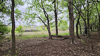
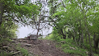
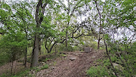
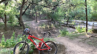
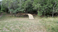
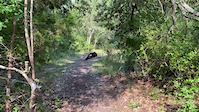
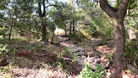
Photos of San Antonio Mountain Bike
Videos of San Antonio Mountain Bike
trail: Crooked Creek Trail
0:07 |
|
Mar 20, 2024
trail: Veterans Pass
0:09 |
|
Mar 20, 2024
trail: Veterans Pass
0:10 |
|
Mar 20, 2024
trail: O.P. Schnabel Park
0:05 |
|
Apr 7, 2021
trail: Veterans Pass
0:48 |
70 |
Jul 2, 2020
trail: Enduro Trail 3
0:12 |
40 |
Jun 1, 2020
trail: Enduro Trail 4
0:15 |
59 |
May 13, 2020

trail: Enduro Trail 4
0:06 |
38 |
May 13, 2020
Recent Trail Reports
| status | trail | date | condition | info | user |
|---|---|---|---|---|---|
| SC21 | Jun 16, 2026 @ 4:29pm (America/Matamoros) Jun 16, 2026 | Wet | Carlie72 | ||
| Shortcut Trail | Jun 13, 2026 @ 9:56am (America/Matamoros) Jun 13, 2026 | Dry | amslotek | ||
| MA10 | Jun 13, 2026 @ 9:56am (America/Matamoros) Jun 13, 2026 | Ideal | amslotek | ||
| East Mud Creek | Jun 13, 2026 @ 9:56am (America/Matamoros) Jun 13, 2026 | Ideal | amslotek | ||
| Bugle | Jun 13, 2026 @ 9:56am (America/Matamoros) Jun 13, 2026 | Dry | amslotek | ||
| Vietnam | Jun 13, 2026 @ 9:56am (America/Matamoros) Jun 13, 2026 | Dry | amslotek | ||
| MA1 | Jun 13, 2026 @ 9:56am (America/Matamoros) Jun 13, 2026 | Ideal | amslotek | ||
| Lila Cockrell Way | Jun 13, 2026 @ 9:56am (America/Matamoros) Jun 13, 2026 | Ideal | amslotek | ||
| North Red | Jun 13, 2026 @ 9:56am (America/Matamoros) Jun 13, 2026 | Dry | amslotek | ||
| Twisty Trail | Jun 13, 2026 @ 9:56am (America/Matamoros) Jun 13, 2026 | Ideal | amslotek |
Activity Feed
| username | action | type | title | date |
|---|---|---|---|---|
| MatthewFi02AG | wishlist | region | activity #97488830 | Jun 21, 2026 @ 8:41am 5 hours |
| Carlie72 | add | report | activity #97178537 | Jun 17, 2026 @ 6:25am Jun 17, 2026 |
| Jbware | add | report | activity #97065465 and 3 more | Jun 15, 2026 @ 2:24pm Jun 15, 2026 |
| amslotek | add | report | activity #96905379 and 11 more | Jun 13, 2026 @ 12:24pm Jun 13, 2026 |
| Rvigeant | add | karma | activity #96737403 | Jun 11, 2026 @ 7:51am Jun 11, 2026 |
Recent Comments
| username | type | title | comment | date |
|---|---|---|---|---|
| trail | Awesome green trail. Great for beginners who... | Feb 19, 2026 @ 9:47pm Feb 19, 2026 | ||
| trail | Mostly green. But be cautious, due to... | Feb 19, 2026 @ 9:43pm Feb 19, 2026 | ||
| trail | One of the smoothest trails in this area. ... | Feb 19, 2026 @ 9:35pm Feb 19, 2026 | ||
| trail | This trail has 2 low-water crossings that may... | Dec 29, 2025 @ 7:05am Dec 29, 2025 | ||
| trail | Steel rail barriers are present at Furnish... | Nov 2, 2025 @ 5:49pm Nov 2, 2025 |
Local Badges
-

Completionist1 awarded -

Top 10 Trails7 awarded -
Completionist13 awarded -
Completionist0 awarded -
Completionist1 awarded -
Completionist0 awarded
Bike & Skill Parks
| name | type | city | rating |
|---|---|---|---|
| McAllister Park Pump Track and Skills Area | skill park | San Antonio | |
| Alamo Heights Bike Park | skill park | San Antonio |
Activity Type Stats
| activitytype | trails | distance | descent | descent distance | total vertical | rating | global rank | state rank | photos | reports | routes | ridelogs |
|---|---|---|---|---|---|---|---|---|---|---|---|---|
| Mountain Bike | 537 | 267 miles | 10,682 ft | 74 miles | 906 ft | #140 | #53 | 566 | 2,297 | 15 | 57,932 | |
| E-Bike | 232 | 121 miles | 4,560 ft | 32 miles | 791 ft | #518 | #724 | 22 | 2,137 | 3 | 1,599 | |
| Gravel Bike | 13 | #21 | #671 | 25 | 2 | 506 | ||||||
| Adaptive Bike | 6 | #380 | #1,724 | 1 | 1 | |||||||
| Winter Fat Bike | 1 | #247 | #1,026 | 6 | ||||||||
| Horse | 60 | 24 miles | 486 ft | 4 miles | 89 ft | #137 | #388 | 199 | 91 | |||
| Hike | 604 | 296 miles | 13,396 ft | 83 miles | 1,024 ft | #127 | #74 | 139 | 2,290 | 5 | 1,896 | |
| Trail Running | 582 | 290 miles | 13,228 ft | 81 miles | 1,024 ft | #244 | #103 | 3 | 2,290 | 4 | 4,427 |
Frequently Asked Questions About San Antonio
▼
What are the best places to ride in San Antonio?
San Antonio has 28 areas to explore for mountain biking. The top rated areas are:
▼
What are the highest rated mountain biking trails in San Antonio?
The highest rated mountain biking trails in San Antonio are:
- Parkwood Tables (4.5/5)
- Carnage Trail (4.4/5)
- Veterans Pass (4.3/5)
- Pebbles & Bam Bam (4.3/5)
- Saddle Way Trail (4.2/5)
▼
What is the best time of the year to ride in San Antonio?
Based on ride log data, the most popular months to ride in San Antonio are:
- July (774 activities)
- June (522 activities)
- August (476 activities)
▼
Where can I park to ride in San Antonio?
There are 67 parking locations listed in San Antonio. The most popular parking spots are: View all parking and trailhead locations on the map to plan your visit.
Activities
Trails
Points of Interest
- North Bluffs Spur Overlook Viewpoint
- Dinosaur Tracks Sight
- Caliche Hill TTF
- Robert L.B. Tobin Land Bridge
- Mission San Juan Capistrano Sight
- Scenic View Viewpoint
- Drop from Calichi Hill Bypass Trail to Blue Loop TTF
- Smooth Drop Across Creek TTF
- Rooty Narrow Drop TTF
- Smooth Drop TTF
- Cap Mountain (1,919 ft)
- Mount Smith (1,896 ft)
- Three Mountains (1,857 ft)
- By Darron91tt
 & contributors
 - Admins: STORM
- #13330 - 28,147 views
- san antonio activity log | embed map of San Antonio mountain bike trails | san antonio mountain biking points of interest polygons
Downloading of trail gps tracks in kml & gpx formats is enabled for San Antonio.
You must login to download files.