close
-
Layers w
- Weather Layers
- Pro
- Pro
- Pro
- Pro
- Pro
- Pro
- More Layers
- Pro
- Pro
- Pro
- Pro
-
Upgrade to

3D
Trail Conditions
- Unknown
- Snow Groomed
- Snow Packed
- Snow Covered
- Snow Cover Partial
- Freeze/thaw Cycle
- Icy
- Prevalent Mud
- Wet
- Variable
- Ideal
- Dry
- Very Dry
Trail Flow (Ridden Direction)
Trailforks scans users ridelogs to determine the most popular direction each trail is ridden. A good flowing trail network will have most trails flowing in a single direction according to their intension.
The colour categories are based on what percentage of riders are riding a trail in its intended direction.
The colour categories are based on what percentage of riders are riding a trail in its intended direction.
- > 96%
- > 90%
- > 80%
- > 70%
- > 50%
- < 50%
- bi-directional trail
- no data
Trail Last Ridden
Trailforks scans ridelogs to determine the last time a trail was ridden.
- < 2 days
- < 1 week
- < 2 weeks
- < 1 month
- < 6 months
- > 6 months
Trail Ridden Direction
The intended direction a trail should be ridden.
- Downhill Only
- Downhill Primary
- Both Directions
- Uphill Primary
- Uphill Only
- One Direction
Contribute Details
Colors indicate trail is missing specified detail.
- Description
- Photos
- Description & Photos
- Videos
Trail Popularity ?
Trailforks scans ridelogs to determine which trails are ridden the most in the last 9 months.
Trails are compared with nearby trails in the same city region with a possible 25 colour shades.
Think of this as a heatmap, more rides = more kinetic energy = warmer colors.
- most popular
- popular
- less popular
- not popular
ATV/ORV/OHV Filter
Max Vehicle Width
inches
US Cell Coverage
Legend

Radar Time
Activity Recordings
Trailforks uses anonymized public activity data.
?
Activity Recordings
Trailforks uses anonymized public activity data.
?
Personal Heatmap
▶
Activity Types
all
/
none
▶
Options
2
Date range
month
–
Winter Trails
Warning
A routing network for winter maps does not exist. Selecting trails using the winter trails layer has been disabled.
Missing Trails
Most Popular
Least Popular
Trails are colored based on popularity. The more popular a trail is, the more red. Less popular trails trend towards green.
Jump Magnitude Heatmap
Heatmap of where riders jump on trails. Zoom in to see individual jumps, click circles to view jump details.
BC Backroad Status
![map legend]()
Service Road Atlas is a free to use, community-driven service for viewing and creating reports on the numerous back-country service roads around B.C. and Alberta.

Slope Aspect
Direction the slope faces
Trails Deemphasized
Trails are shown in grey.
Only show trails with no bike usage.
Suggested Layers
Based on selected activity type
Save the current map location and zoom level as your default home location whenever this page is loaded.
SaveSan Leonardo (Svet Lienart o anche Podutana in sloveno[4], San Lenàrt in friulano[5]) è un comune italiano di 1 069 abitanti del Friuli-Venezia Giulia. Si tratta di un comune sparso in quanto la sede comunale non è nel borgo omonimo ma nella frazione di Merso di Sopra.
This region uses the Uk/Euro style trail grading system.
Activities Click to view
- Mountain Bike
16 trails
- E-Bike
8 trails
- Adaptive Bike
0 trails
- Winter Fat Bike
1 trails
- Hike
16 trails
- Trail Running
16 trails
Region Details
- 5
- 3
- 2
- 2
Region Status
Caution as of Mar 3, 2026Stats
- Avg Trail Rating
- Trails (view details)
- 12
- Trails Mountain Bike
- 16
- Trails E-Bike
- 8
- Trails Winter Fat Bike
- 1
- Trails Hike
- 16
- Trails Trail Running
- 16
- Total Distance
- 19 miles
- Total Descent Distance
- 9 miles
- Total Descent
- 7,408 ft
- Total Vertical
- 1,560 ft
- Highest Trailhead
- 2,019 ft
- Reports
- 92
- Photos
- 8
- Ridden Counter
- 691
Sub Regions
-
Natisone Bike Arena (S.Leonardo)
- 1
- 1
- 1
Popular San Leonardo Mountain Biking Trails
• 100 ★ 4.4 • 1 mile • 2 ft • 174 •
Percorso molto conosciuto che dalla località porta fino a valle. Percorso interamente nel bosco con alcuni tratti di mulattiera ciottolata. Troviamo da subito una parte veloce e guidabile ma con qualche piccolo rilancio seguita da due...
• 75 ★ 4.7 • 3,104 ft • 0 ft • 82 •
Il trail prende il nome dall’omonima frazione del Comune di San Leonardo ed è stato tracciato e utilizzato per la prima volta per l’edizione 2019 della classica gara di enduro “Krivapete” che si svolge da anni tra i mesi di...
• 25 ★ 3.2 • 1 mile • 35 ft • 76 •
Less popular red difficulty singletrack. This mountain bike primary trail can be used downhill only and has a hard overall physical rating. On average it takes 12 minutes to complete this trail.
• 50 ★ 4.4 • 3,212 ft • 0 ft • 73 •
Moderately popular black difficulty singletrack. This mountain bike primary trail and has a hard overall physical rating. On average it takes 12 minutes to complete this trail.
• 70 ★ 4.0 • 1 mile • 0 ft • 53 •
Il sentiero è la variante “facile” di CLASTRA . L’avvicinamento è il medesimo, così come la zona di partenza. Si raggiunge percorrendo la comoda strada asfaltata comunale in direzione della frazione di Clastra, abbandonandola...
• 10 ★ 0.0 • 1 mile • 43 ft • 5 •
Less popular blue difficulty singletrack. This mountain bike primary trail can be used downhill primary. Trail visibility is always easy to follow. On average it takes 7 minutes to complete this trail.
San Leonardo Mountain Bike Routes
9 miles • 1,881 ft • 1 •
Percorso XC(E-bike) che partendo da S.Leonardo ci porta al santuario di Castelmonte utilizzando la...
19 miles • 4,393 ft • 0 •
Il percorso XC (E-bike) parte da San Leonardo e percorre, per il primo tratto, la strada provinciale verso...
21 miles • 3,771 ft • 0 •
Classico giro panoramico delle Valli. Si parte da S.Leonardo su strada asfaltata per poi girare subito...
Videos of San Leonardo Mountain Bike
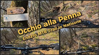
trail: Occhio alla Penna
5:06 |
100 |
Mar 13, 2025 , San Leonardo
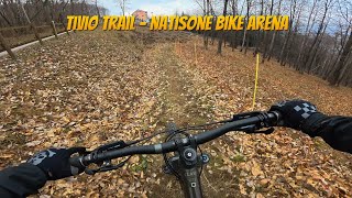
trail: Trivio Trail
8:05 |
139 |
Mar 13, 2025 , San Leonardo

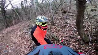
trail: Clastra Trail
4:12 |
172 |
Mar 3, 2025 , San Leonardo
trail: Trivio Trail
7:49 |
924 |
Jan 30, 2020 , San Leonardo
Recent Trail Reports
| status | trail | date | condition | info | user |
|---|---|---|---|---|---|
| Trivio Trail | Mar 3, 2026 @ 3:22pm (Europe/Rome) Mar 3, 2026 | Wet | SaraLipnik | ||
| Clastra Trail | Mar 3, 2026 @ 3:19pm (Europe/Rome) Mar 3, 2026 | Ideal | SaraLipnik | ||
| Spik Trail | Nov 30, 2025 @ 8:00am (Europe/Rome) Nov 29, 2025 | Prevalent Mud | timnovak | ||
| LA BAITA | Nov 30, 2025 @ 7:59am (Europe/Rome) Nov 29, 2025 | Variable | timnovak | ||
| Bunker Trail | Jun 29, 2025 @ 11:46am Jun 29, 2025 | Dry | Dennis91 | ||
| Occhio alla Penna | May 2, 2025 @ 6:05am May 2, 2025 | Dry | christiancXnft | ||
| Salita ai trails di Clastra | Sep 25, 2024 @ 8:10am Sep 25, 2024 | Variable | crisotop UpperTrails | ||
| Rientro a S.Leonardo | Feb 17, 2024 @ 3:37am Feb 17, 2024 | Variable | lollottanta | ||
| Rientro a S.Leonardo | Feb 17, 2024 @ 3:37am Feb 17, 2024 | Variable | lollottanta | ||
| Marcolino | Jun 25, 2023 @ 11:33am Jun 25, 2023 | Unknown | Lucjus |
Activity Feed
| username | action | type | title | date |
|---|---|---|---|---|
| r2h2 | wishlist | trail | activity #97000480 | Jun 14, 2026 @ 1:26pm Jun 14, 2026 |
| himmelan | wishlist | trail | activity #96800784 | Jun 12, 2026 @ 6:57am Jun 12, 2026 |
| Steferman | wishlist | trail | activity #92305517 | Apr 10, 2026 @ 12:32am Apr 10, 2026 |
| Bibus | ridden | trail | activity #92056751 | Apr 6, 2026 @ 8:46am Apr 6, 2026 |
| TobiasCjiUpw | wishlist | trail | activity #91728522 | Apr 1, 2026 @ 2:37pm Apr 1, 2026 |
Recent Comments
| username | type | title | comment | date |
|---|---|---|---|---|
| trail | bester trail !! 👍🏻 | Mar 22, 2026 @ 1:30am Mar 22, 2026 | ||
| trail | gut gepflegt 👍🏻 | Mar 22, 2026 @ 1:29am Mar 22, 2026 | ||
| report | gut gepflegt | Mar 22, 2026 @ 1:28am Mar 22, 2026 | ||
| trail | Man, this is what Enduro means to me. It's... | Sep 14, 2025 @ 6:12am Sep 14, 2025 | ||
| trail | That is hard, expecially in this condition.... | Sep 14, 2025 @ 6:10am Sep 14, 2025 |
Local Badges
-

Epic Mountain Bike Climb 2k31 awarded -

Climbing 10k Badge8 awarded -

Mountain Biking 100k Badge1 awarded -

Big Ride 30k170 awarded -

Epic Ride 50k74 awarded -

Epic Ride Descent 2k0 awarded
Activity Type Stats
| activitytype | trails | distance | descent | descent distance | total vertical | rating | global rank | state rank | photos | reports | routes | ridelogs |
|---|---|---|---|---|---|---|---|---|---|---|---|---|
| Mountain Bike | 16 | 19 miles | 7,408 ft | 9 miles | 1,562 ft | #7,869 | #694 | 8 | 92 | 3 | 1,122 | |
| E-Bike | 8 | 6 miles | 1,644 ft | 3 miles | 804 ft | #7,884 | #857 | 45 | 2 | 94 | ||
| Winter Fat Bike | 1 | #310 | #353 | |||||||||
| Hike | 16 | 19 miles | 7,408 ft | 9 miles | 1,562 ft | #8,112 | #486 | 93 | 78 | |||
| Trail Running | 16 | 19 miles | 7,408 ft | 9 miles | 1,562 ft | #7,662 | #475 | 93 | 4 |
Frequently Asked Questions About San Leonardo
▼
What are the best places to ride in San Leonardo?
San Leonardo has 1 areas to explore for mountain biking. The top rated areas are:
▼
What are the highest rated mountain biking trails in San Leonardo?
The highest rated mountain biking trails in San Leonardo are:
- Clastra Trail (4.3/5)
- Trivio Trail (4.2/5)
- LA BAITA (4.1/5)
- Occhio alla Penna (4/5)
- Bunker Trail (4/5)
▼
What is the best time of the year to ride in San Leonardo?
Based on ride log data, the most popular months to ride in San Leonardo are:
- August (11 activities)
- October (8 activities)
- May (7 activities)
▼
Where can I park to ride in San Leonardo?
There are 2 parking locations listed in San Leonardo. The most popular parking spots are:
Activities
Trails
Points of Interest
- By maxmisdaris
 MGNR & contributors
 - Admins: maxmisdaris
- #41181 - 1,250 views
- san leonardo activity log | embed map of San Leonardo mountain bike trails | san leonardo mountain biking points of interest
Downloading of trail gps tracks in kml & gpx formats is enabled for San Leonardo.
You must login to download files.