close
-
Layers w
- Weather Layers
- Pro
- Pro
- Pro
- Pro
- Pro
- Pro
- More Layers
- Pro
- Pro
- Pro
- Pro
-
Upgrade to

3D
Trail Conditions
- Unknown
- Snow Groomed
- Snow Packed
- Snow Covered
- Snow Cover Partial
- Freeze/thaw Cycle
- Icy
- Prevalent Mud
- Wet
- Variable
- Ideal
- Dry
- Very Dry
Trail Flow (Ridden Direction)
Trailforks scans users ridelogs to determine the most popular direction each trail is ridden. A good flowing trail network will have most trails flowing in a single direction according to their intension.
The colour categories are based on what percentage of riders are riding a trail in its intended direction.
The colour categories are based on what percentage of riders are riding a trail in its intended direction.
- > 96%
- > 90%
- > 80%
- > 70%
- > 50%
- < 50%
- bi-directional trail
- no data
Trail Last Ridden
Trailforks scans ridelogs to determine the last time a trail was ridden.
- < 2 days
- < 1 week
- < 2 weeks
- < 1 month
- < 6 months
- > 6 months
Trail Ridden Direction
The intended direction a trail should be ridden.
- Downhill Only
- Downhill Primary
- Both Directions
- Uphill Primary
- Uphill Only
- One Direction
Contribute Details
Colors indicate trail is missing specified detail.
- Description
- Photos
- Description & Photos
- Videos
Trail Popularity ?
Trailforks scans ridelogs to determine which trails are ridden the most in the last 9 months.
Trails are compared with nearby trails in the same city region with a possible 25 colour shades.
Think of this as a heatmap, more rides = more kinetic energy = warmer colors.
- most popular
- popular
- less popular
- not popular
ATV/ORV/OHV Filter
Max Vehicle Width
inches
US Cell Coverage
Legend

Radar Time
Activity Recordings
Trailforks uses anonymized public activity data.
?
Activity Recordings
Trailforks uses anonymized public activity data.
?
Personal Heatmap
▶
Activity Types
all
/
none
▶
Options
2
Date range
month
–
Winter Trails
Warning
A routing network for winter maps does not exist. Selecting trails using the winter trails layer has been disabled.
Missing Trails
Most Popular
Least Popular
Trails are colored based on popularity. The more popular a trail is, the more red. Less popular trails trend towards green.
Jump Magnitude Heatmap
Heatmap of where riders jump on trails. Zoom in to see individual jumps, click circles to view jump details.
BC Backroad Status
![map legend]()
Service Road Atlas is a free to use, community-driven service for viewing and creating reports on the numerous back-country service roads around B.C. and Alberta.

Slope Aspect
Direction the slope faces
Trails Deemphasized
Trails are shown in grey.
Only show trails with no bike usage.
Suggested Layers
Based on selected activity type
Save the current map location and zoom level as your default home location whenever this page is loaded.
Save
No description for Santurtzi has been added yet!
Login or register to submit one.
This region uses the Uk/Euro style trail grading system.
Activities Click to view
- Mountain Bike
103 trails
- E-Bike
102 trails
- Adaptive Bike
- Hike
102 trails
- Trail Running
102 trails
Region Details
- 37
- 11
- 27
- 21
- 7
Region Status
Open as of Jun 16, 2026Stats
- Avg Trail Rating
- Trails (view details)
- 103
- Trails Mountain Bike
- 103
- Trails E-Bike
- 102
- Trails Horse
- 1
- Trails Hike
- 102
- Trails Trail Running
- 102
- Trails Dirtbike/Moto
- 1
- Trails Observed Trials
- 1
- Total Distance
- 55 miles
- Total Descent Distance
- 26 miles
- Total Descent
- 14,174 ft
- Total Vertical
- 1,432 ft
- Highest Trailhead
- 1,440 ft
- Reports
- 638
- Photos
- 305
- Ridden Counter
- 3,290
Sub Regions
-
Ezkerraldea Kosta
- 11
- 27
- 21
- 7
Popular Santurtzi Mountain Biking Trails
• 100 ★ 3.0 • 3 miles • 188 ft • 90 •
Bidegorri que une el barrio de Sanfuentes con Mamariga.
• 80 ★ 4.7 • 2 miles • 0 ft • 81 •
Clásica entre las clásicas: la bajada por lo alto del Serantes es larga y divertida. Partimos de la antena para tomar una primera parte con menos pendiente en la que habrá que bombear ya que es complicado pedalear en algunos tramos....
• 100 ★ 3.0 • 1,152 ft • 114 ft • 75 •
Alternativa un poco menos dura a la subida de que zigzaguea por su parte izquierda. También puede utilizarse como descenso pero son más divertodos los de Mamariga o El Mazo.
• 90 ★ 5.0 • 1,066 ft • 0 ft • 64 •
Zona que requiere técnica y no cometer fallos para evitar caídas por la ladera. El single track esta limpio y es sencillo.
• 80 ★ 5.0 • 1,270 ft • 27 ft • 52 •
Sendero que rodea al Fuerte del Serantes: comenzamos por la zona de mesas de la izquierda de la entrada buscando el foso y un divertido sendero descendente nos acerca a la pista de cemento. Aquí tenemos un tramo muy descendente en el...
• 95 ★ 4.0 • 1,273 ft • 0 ft • 52 •
En la estaca blanca del collado seguimos recto con fuerte pendiente. Enseguida se tranquiliza pero el sendero tiene su miga: está muy hundido por la erossión y los pedales pegan con facilidad al pedalear. Es factible hacerlo subiendo...
• 95 ★ 4.0 • 2,552 ft • 0 ft • 52 •
Bonito sendero con mucha roca madre. En bajada el inicio es algo más complicado que el final. En subida es todo un reto para las e-bikes.
• 90 ★ 4.5 • 2,306 ft • 18 ft • 49 •
Sendero que enlaza el Collado del Portal con la carretera de acceso a la Urbanización de La Magdalena. Estrecho y curveado, tiene muchas argomas en los márgenes lo que puede complicar el paso si no se desbroza adecuadamente. Es útil...
Santurtzi Mountain Bike Routes
37 miles • 6,125 ft • 24 • Loop •
Exigente ruta de all mountain que nos llevará por dos zonas muy bien diferenciadas: por un lado, el...
★ 3.0 • 22 miles • 4,806 ft • 18 • Loop •
Un desafío en el que disfutaremos tanto de las subidas como de las bajadas más técnicas del entorno de...
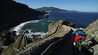
Photos of Santurtzi Mountain Bike
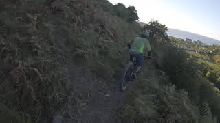
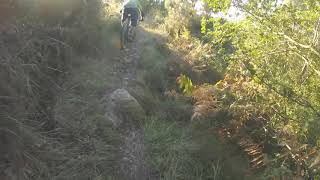
Videos of Santurtzi Mountain Bike
trail: San Juan
0:50 |
450 |
Oct 20, 2016
trail: El Peñón
2:12 |
238 |
Sep 3, 2020 , Santurtzi
trail: Cordal del Montaño
3:49 |
324 |
Sep 3, 2020 , Santurtzi

trail: La Rocosa
3:58 |
315 |
Jun 23, 2020 , Santurtzi

trail: Cordal de Punta Lucero
3:58 |
356 |
Jun 23, 2020 , Santurtzi

trail: Punta Lucero - La Arena
3:04 |
305 |
Jun 23, 2020 , Santurtzi

trail: Cordal del Serantes
3:30 |
446 |
Jun 16, 2020 , Santurtzi

trail: Alternativa a la Perrera
2:12 |
269 |
Apr 26, 2020 , Santurtzi
Recent Trail Reports
| status | trail | date | condition | info | user |
|---|---|---|---|---|---|
| Punta Lucero - La Arena | Jun 16, 2026 @ 2:42pm (Europe/Madrid) Jun 16, 2026 | Dry | krasty1002 TMD | ||
| Pista de la Atalaya | Jun 16, 2026 @ 2:42pm (Europe/Madrid) Jun 16, 2026 | Ideal | krasty1002 TMD | ||
| Cemento Punta Lucero | Jun 16, 2026 @ 2:42pm (Europe/Madrid) Jun 16, 2026 | Ideal | krasty1002 TMD | ||
| Portal | Jun 16, 2026 @ 2:42pm (Europe/Madrid) Jun 16, 2026 | Dry | krasty1002 TMD | ||
| Pico Emilio | Jun 16, 2026 @ 2:42pm (Europe/Madrid) Jun 16, 2026 | Dry | krasty1002 TMD | ||
| Berza | Jun 16, 2026 @ 2:42pm (Europe/Madrid) Jun 16, 2026 | Dry | krasty1002 TMD | ||
| Enlace Sur del Serantes | Jun 16, 2026 @ 2:42pm (Europe/Madrid) Jun 16, 2026 | Dry | krasty1002 TMD | ||
| Hayedo Bajo | Jun 16, 2026 @ 2:42pm (Europe/Madrid) Jun 16, 2026 | Dry | krasty1002 TMD | ||
| Agro | Jun 16, 2026 @ 2:42pm (Europe/Madrid) Jun 16, 2026 | Ideal | krasty1002 TMD | ||
| Cordal del Serantes | Jun 16, 2026 @ 2:42pm (Europe/Madrid) Jun 16, 2026 | Ideal | krasty1002 TMD |
Activity Feed
| username | action | type | title | date |
|---|---|---|---|---|
| krasty1002 | add | report | activity #97168628 and 10 more | Jun 17, 2026 @ 1:26am Jun 17, 2026 |
| krasty1002 | add | trail | activity #97130581 | Jun 16, 2026 @ 12:20pm Jun 16, 2026 |
| krasty1002 | add | trail | activity #96996195 | Jun 14, 2026 @ 12:36pm Jun 14, 2026 |
| krasty1002 | update | trail | activity #96996064 | Jun 14, 2026 @ 12:34pm Jun 14, 2026 |
| krasty1002 | add | report | activity #96925050 | Jun 13, 2026 @ 4:29pm Jun 13, 2026 |
Recent Comments
| username | type | title | comment | date |
|---|---|---|---|---|
| report | Eso con un serrucho se despeja en 10... | Apr 16, 2026 @ 11:12pm Apr 16, 2026 | ||
| report | SENDERO CERRADO , AVISADO AL FORESTAL | Apr 16, 2026 @ 10:00am Apr 16, 2026 | ||
| trail | SENDERO CERRADO | Oct 28, 2023 @ 7:38am Oct 28, 2023 | ||
| trail | No está de más llevar un timbre en la bici... | Jul 5, 2022 @ 11:27pm Jul 5, 2022 | ||
| trail | Esta bien como enlace, el estado es bueno. | Nov 18, 2021 @ 7:32am Nov 18, 2021 |
Local Badges
-

Completionist0 awarded -

Epic Mountain Bike Climb 2k186 awarded -

Climbing 10k Badge35 awarded -

Mountain Biking 100k Badge4 awarded -

Epic Ride Descent 2k186 awarded -

Descent 10k Badge35 awarded
Activity Type Stats
| activitytype | trails | distance | descent | descent distance | total vertical | rating | global rank | state rank | photos | reports | routes | ridelogs |
|---|---|---|---|---|---|---|---|---|---|---|---|---|
| Mountain Bike | 103 | 55 miles | 14,173 ft | 26 miles | 1,434 ft | #2,636 | #205 | 295 | 636 | 2 | 6,428 | |
| E-Bike | 102 | 55 miles | 14,154 ft | 26 miles | 1,434 ft | #2,236 | #292 | 8 | 631 | 2 | 1,020 | |
| Horse | 1 | 2 miles | 427 ft | 4,472 ft | 463 ft | 5 | ||||||
| Hike | 102 | 55 miles | 14,173 ft | 26 miles | 1,434 ft | #3,738 | #267 | 2 | 628 | 514 | ||
| Trail Running | 102 | 55 miles | 14,173 ft | 26 miles | 1,434 ft | #3,214 | #260 | 623 | 406 | |||
| Dirtbike/Moto | 1 | 2 miles | 427 ft | 4,472 ft | 463 ft | 5 | ||||||
| Observed Trials | 1 | 2 miles | 427 ft | 4,472 ft | 463 ft | 4 |
Frequently Asked Questions About Santurtzi
▼
What are the best places to ride in Santurtzi?
Santurtzi has 1 areas to explore for mountain biking. The top rated areas are:
▼
What are the highest rated mountain biking trails in Santurtzi?
The highest rated mountain biking trails in Santurtzi are:
- Hayedo Bajo (4.2/5)
- Cordal de Punta Lucero (4.2/5)
- La Rocosa (4.2/5)
- Punta Lucero - La Arena (4.2/5)
- Cordal del Serantes (4.2/5)
▼
What is the best time of the year to ride in Santurtzi?
Based on ride log data, the most popular months to ride in Santurtzi are:
- September (36 activities)
- May (30 activities)
- December (26 activities)
▼
Where can I park to ride in Santurtzi?
There are 8 parking locations listed in Santurtzi. The most popular parking spots are:
- Parking Playa de La Arena
- Aparcamiento La Cuesta Zierbena
- Aparcamiento Kobaron
- Aparcamiento Pobeña
- Aparcamiento San Jorge Santurtzi
Activities
Trails
Points of Interest
- By IMBAEuskadi
 & contributors
 - Admins: Altavoz, krasty1002, Altavoz, krasty1002
- #34374 - 1,408 views
- santurtzi activity log | embed map of Santurtzi mountain bike trails | santurtzi mountain biking points of interest
Downloading of trail gps tracks in kml & gpx formats is enabled for Santurtzi.
You must login to download files.