close
-
Layers w
- Weather Layers
- Pro
- Pro
- Pro
- Pro
- Pro
- Pro
- More Layers
- Pro
- Pro
- Pro
- Pro
-
Upgrade to

3D
Trail Conditions
- Unknown
- Snow Groomed
- Snow Packed
- Snow Covered
- Snow Cover Partial
- Freeze/thaw Cycle
- Icy
- Prevalent Mud
- Wet
- Variable
- Ideal
- Dry
- Very Dry
Trail Flow (Ridden Direction)
Trailforks scans users ridelogs to determine the most popular direction each trail is ridden. A good flowing trail network will have most trails flowing in a single direction according to their intension.
The colour categories are based on what percentage of riders are riding a trail in its intended direction.
The colour categories are based on what percentage of riders are riding a trail in its intended direction.
- > 96%
- > 90%
- > 80%
- > 70%
- > 50%
- < 50%
- bi-directional trail
- no data
Trail Last Ridden
Trailforks scans ridelogs to determine the last time a trail was ridden.
- < 2 days
- < 1 week
- < 2 weeks
- < 1 month
- < 6 months
- > 6 months
Trail Ridden Direction
The intended direction a trail should be ridden.
- Downhill Only
- Downhill Primary
- Both Directions
- Uphill Primary
- Uphill Only
- One Direction
Contribute Details
Colors indicate trail is missing specified detail.
- Description
- Photos
- Description & Photos
- Videos
Trail Popularity ?
Trailforks scans ridelogs to determine which trails are ridden the most in the last 9 months.
Trails are compared with nearby trails in the same city region with a possible 25 colour shades.
Think of this as a heatmap, more rides = more kinetic energy = warmer colors.
- most popular
- popular
- less popular
- not popular
ATV/ORV/OHV Filter
Max Vehicle Width
inches
US Cell Coverage
Legend

Radar Time
Activity Recordings
Trailforks uses anonymized public activity data.
?
Activity Recordings
Trailforks uses anonymized public activity data.
?
Personal Heatmap
▶
Activity Types
all
/
none
▶
Options
2
Date range
month
–
Winter Trails
Warning
A routing network for winter maps does not exist. Selecting trails using the winter trails layer has been disabled.
Missing Trails
Most Popular
Least Popular
Trails are colored based on popularity. The more popular a trail is, the more red. Less popular trails trend towards green.
Jump Magnitude Heatmap
Heatmap of where riders jump on trails. Zoom in to see individual jumps, click circles to view jump details.
BC Backroad Status
![map legend]()
Service Road Atlas is a free to use, community-driven service for viewing and creating reports on the numerous back-country service roads around B.C. and Alberta.

Slope Aspect
Direction the slope faces
Trails Deemphasized
Trails are shown in grey.
Only show trails with no bike usage.
Suggested Layers
Based on selected activity type
Save the current map location and zoom level as your default home location whenever this page is loaded.
SaveS.A.R.A. (Special Activities and Recreation Area) Park is an 1100- acre regional park with spectacular mountain views and access to Lake Havasu.
source: SARA PARK
 google parking directions
 Access Info:
Parking Lot 1 (All Facilities) & Parking Lot 2
Activities Click to view
- Mountain Bike
67 trails
- E-Bike
67 trails
- Hike
65 trails
- Trail Running
65 trails
Region Details
- 3
- 1
- 22
- 25
- 12
- 4
Region Status
Open as of Feb 4, 2026Stats
- Avg Trail Rating
- Trails (view details)
- 70
- Trails Mountain Bike
- 67
- Trails E-Bike
- 67
- Trails Hike
- 65
- Trails Trail Running
- 65
- Total Distance
- 82 miles
- Total Descent
- 12,152 ft
- Total Vertical
- 902 ft
- Highest Trailhead
- 1,358 ft
- Reports
- 287
- Photos
- 479
- Ridden Counter
- 7,325
Popular SARA Park Mountain Biking Trails
• 100 ★ 3.3 • 9 miles • 784 ft • 537 •
Original write-up on this trail (February 2002), from WanderLucky.com (site is no longer available) - Trailshot: First, more than four miles of typical low desert road. Some sand, some rocks, a good long warmup for what's to come. After...
• 95 ★ 3.5 • 1 mile • 232 ft • 255 •
Really fun XC trail. If you're not up to riding the , or a longer loop. You can use to cut the loop in half. Good mix of ups and downs. Flows best from Water Shed down toward the Lake.
• 85 ★ 4.2 • 3 miles • 318 ft • 243 •
Fast, fun XC warmup before riding the trails across the road.
• 90 ★ 3.8 • 4,006 ft • 3 ft • 205 •
is a great trail to take visitors on. You get to ride some fun XC single track, and also ride right down to the lake, awesome! To return to the Trailhead, you can either backtrack your line, or catch the leading back up to .
• 90 ★ 3.7 • 1 mile • 56 ft • 203 •
Fun XC section, mostly downhill grade. More rocks than some of the other surrounding trails. Ends at the bottom of Heart Attack Hill.
• 90 ★ 5.0 • 2,372 ft • 83 ft • 189 •
After dropping in on Down Hill to Red Rock stay STRAIGHT at the bottom and shred this trail all the way up and through the canyon to pickup your trail of choice: , or go straight onto . A great option to climb out so don't be scared to...
• 70 ★ 4.0 • 388 ft • 7 ft • 177 •
Downhill is definitely the preferred direction. This is a fun Strava Segment.
SARA Park Mountain Bike Routes
★ 5.0 • 5 miles • 587 ft • 7 • Loop •
This is a Super Fun LOOP with lots of technical sections, off cambers, uphills, downhills, jumps, berms...
★ 3.7 • 17 miles • 1,990 ft • 53 • Loop •
The easiest of the "Spaghetti Loop Trilogy". Multiple intersecting loops around SARA Park without...
★ 5.0 • 12 miles • 994 ft • 4 • Loop •
Fun loop taking in a few of the trails in the NE part of the park.
★ 3.0 • 18 miles • 2,650 ft • 39 • Loop •
The last of the "Spaghetti Loop Trilogy", pretty much all the hard SARA trails looped into one hard route....
★ 3.0 • 19 miles • 2,386 ft • 45 • Loop •
The second of the "Spaghetti Loop Trilogy", and a slightly harder variation to with an extra loop up and...
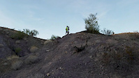
Photos of SARA Park Mountain Bike
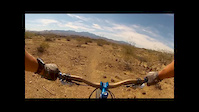
Videos of SARA Park Mountain Bike
trail: Cosmic
0:08 |
447 |
Nov 24, 2016

trail: Social
3:44 |
221 |
May 25, 2015
trail: Alternate
4:46 |
114 |
Jul 14, 2014

trail: Critters
5:05 |
47 |
Apr 21, 2026 , Lake Havasu City
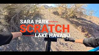
trail: Scratch
5:31 |
22 |
Apr 21, 2026 , Lake Havasu City

trail: Recycle
3:48 |
17 |
Apr 21, 2026 , Lake Havasu City
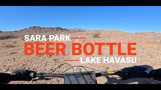
trail: Beer Bottle
4:07 |
60 |
Apr 11, 2026 , Lake Havasu City

trail: Watts Up
4:21 |
14 |
Apr 10, 2026 , Lake Havasu City
Recent Trail Reports
| status | trail | date | condition | info | user |
|---|---|---|---|---|---|
| Water Shed Loop | Feb 4, 2026 @ 9:46am (America/Phoenix) Feb 4, 2026 | Ideal | gabe675 | ||
| Exit 191 | Feb 4, 2026 @ 9:46am (America/Phoenix) Feb 4, 2026 | Ideal | gabe675 | ||
| Hike Naked | Nov 9, 2024 @ 1:35pm Nov 9, 2024 | Very Dry | nicoli | ||
| Alternate | Jun 19, 2024 @ 11:30am Jun 19, 2024 | Snow Packed | Larrycsr | ||
| Santa's Sleigh Ride | Mar 5, 2024 @ 9:16am Mar 5, 2024 | Ideal | Bridgesglenn | ||
| High Voltage | Mar 5, 2024 @ 9:16am Mar 5, 2024 | Dry | Bridgesglenn | ||
| Trash Can | Mar 5, 2024 @ 9:16am Mar 5, 2024 | Ideal | Bridgesglenn | ||
| Connector | Feb 21, 2024 @ 2:04am Feb 21, 2024 | Ideal | Thesandini | ||
| Dodging Bullets | Feb 5, 2024 @ 6:59am Feb 5, 2024 | Ideal | Thesandini | ||
| Beer Bottle | Feb 4, 2024 @ 6:47am Feb 4, 2024 | Ideal | Thesandini |
Activity Feed
| username | action | type | title | date |
|---|---|---|---|---|
| Neyloj2 | wishlist | trail | activity #94457809 | May 10, 2026 @ 1:59pm May 10, 2026 |
| rethoracle | wishlist | trail | activity #94371667 | May 9, 2026 @ 1:01pm May 9, 2026 |
| Doylem | ridden | trail | activity #93196379 | Apr 22, 2026 @ 11:26pm Apr 22, 2026 |
| DelSneath | wishlist | route | activity #93195646 | Apr 22, 2026 @ 10:57pm Apr 22, 2026 |
| DelSneath | add | video | activity #93127873 and 2 more | Apr 21, 2026 @ 9:07pm Apr 21, 2026 |
Recent Comments
| username | type | title | comment | date |
|---|---|---|---|---|
| report | Great fun flowy trail | Jan 14, 2026 @ 1:59pm Jan 14, 2026 | ||
| report | Great trail! Mostly fun n flowy! Of course... | Jan 14, 2026 @ 1:58pm Jan 14, 2026 | ||
| report | Fun flowy trail lots of short up n downs. | Jan 14, 2026 @ 1:49pm Jan 14, 2026 | ||
| report | Fun trail, lots of drops short climbs. | Jan 14, 2026 @ 1:48pm Jan 14, 2026 | ||
| report | Trail goes by shooting range, could use more... | Jan 14, 2026 @ 1:48pm Jan 14, 2026 |
Local Badges
-

Completionist0 awarded
Bike & Skill Parks
| name | type | city | rating |
|---|---|---|---|
| Lake Havasu Motocross Park | skill park | Lake Havasu City |
Activity Type Stats
| activitytype | trails | distance | descent | descent distance | total vertical | rating | global rank | state rank | photos | reports | routes | ridelogs |
|---|---|---|---|---|---|---|---|---|---|---|---|---|
| Mountain Bike | 67 | 81 miles | 11,565 ft | 35 miles | 712 ft | #1,887 | #632 | 465 | 284 | 8 | 9,531 | |
| E-Bike | 67 | 81 miles | 11,565 ft | 35 miles | 712 ft | #1,597 | #688 | 3 | 213 | 1 | 1,711 | |
| Hike | 65 | 79 miles | 11,742 ft | 34 miles | 902 ft | #248 | #151 | 11 | 268 | 1 | 1,062 | |
| Trail Running | 65 | 79 miles | 11,742 ft | 34 miles | 902 ft | #2,148 | #511 | 268 | 1 | 425 |
Frequently Asked Questions About SARA Park
▼
What are the highest rated mountain biking trails in SARA Park?
The highest rated mountain biking trails in SARA Park are:
- Multiple Offers WRE (4.2/5)
- High Voltage (4.2/5)
- Wendricks Way (4.1/5)
- Braaap (4.1/5)
- Sorudne Bypass (4.1/5)
▼
What is the best time of the year to ride in SARA Park?
Based on ride log data, the most popular months to ride in SARA Park are:
- November (168 activities)
- December (134 activities)
- March (105 activities)
▼
Where can I park to ride in SARA Park?
There are 4 parking locations listed in SARA Park. The most popular parking spots are: View all parking and trailhead locations on the map to plan your visit.
▼
What is the longest trail in SARA Park?
The longest trail in SARA Park is Water Shed Loop at 9.0 miles. View all trails sorted by distance.
Activities
Trails
Points of Interest
- By brenthillier
 NSMBA TRAILFORKS & contributors
 - Admins: Sorudne
- #9332 - 19,928 views
- sara park activity log | embed map of SARA Park mountain bike trails | sara park mountain biking points of interest
Downloading of trail gps tracks in kml & gpx formats is enabled for SARA Park.
You must login to download files.