close
-
Layers w
- Weather Layers
- Pro
- Pro
- Pro
- Pro
- Pro
- Pro
- More Layers
- Pro
- Pro
- Pro
- Pro
-
Upgrade to

3D
Trail Conditions
- Unknown
- Snow Groomed
- Snow Packed
- Snow Covered
- Snow Cover Partial
- Freeze/thaw Cycle
- Icy
- Prevalent Mud
- Wet
- Variable
- Ideal
- Dry
- Very Dry
Trail Flow (Ridden Direction)
Trailforks scans users ridelogs to determine the most popular direction each trail is ridden. A good flowing trail network will have most trails flowing in a single direction according to their intension.
The colour categories are based on what percentage of riders are riding a trail in its intended direction.
The colour categories are based on what percentage of riders are riding a trail in its intended direction.
- > 96%
- > 90%
- > 80%
- > 70%
- > 50%
- < 50%
- bi-directional trail
- no data
Trail Last Ridden
Trailforks scans ridelogs to determine the last time a trail was ridden.
- < 2 days
- < 1 week
- < 2 weeks
- < 1 month
- < 6 months
- > 6 months
Trail Ridden Direction
The intended direction a trail should be ridden.
- Downhill Only
- Downhill Primary
- Both Directions
- Uphill Primary
- Uphill Only
- One Direction
Contribute Details
Colors indicate trail is missing specified detail.
- Description
- Photos
- Description & Photos
- Videos
Trail Popularity ?
Trailforks scans ridelogs to determine which trails are ridden the most in the last 9 months.
Trails are compared with nearby trails in the same city region with a possible 25 colour shades.
Think of this as a heatmap, more rides = more kinetic energy = warmer colors.
- most popular
- popular
- less popular
- not popular
ATV/ORV/OHV Filter
Max Vehicle Width
inches
US Cell Coverage
Legend

Radar Time
Activity Recordings
Trailforks uses anonymized public activity data.
?
Activity Recordings
Trailforks uses anonymized public activity data.
?
Personal Heatmap
▶
Activity Types
all
/
none
▶
Options
2
Date range
month
–
Winter Trails
Warning
A routing network for winter maps does not exist. Selecting trails using the winter trails layer has been disabled.
Missing Trails
Most Popular
Least Popular
Trails are colored based on popularity. The more popular a trail is, the more red. Less popular trails trend towards green.
Jump Magnitude Heatmap
Heatmap of where riders jump on trails. Zoom in to see individual jumps, click circles to view jump details.
BC Backroad Status
![map legend]()
Service Road Atlas is a free to use, community-driven service for viewing and creating reports on the numerous back-country service roads around B.C. and Alberta.

Slope Aspect
Direction the slope faces
Trails Deemphasized
Trails are shown in grey.
Only show trails with no bike usage.
Suggested Layers
Based on selected activity type
Save the current map location and zoom level as your default home location whenever this page is loaded.
SaveSarajevo (/ˌsærəˈjeɪvoʊ/ SARR-ə-YAY-voh; Cyrillic: Сарајево, pronounced [sǎrajeʋo] (About this soundlisten); see names in other languages) is the capital[6] and largest city of Bosnia and Herzegovina, with a population of 275,569 in its administrative limits.[7][5] The Sarajevo metropolitan area including Sarajevo Canton, East Sarajevo and nearby municipalities is home to 555,210 inhabitants.[a][5] Located within the greater Sarajevo valley of Bosnia, it is surrounded by the Dinaric Alps and situated along the Miljacka River in the heart of the Balkans, a region of Southern Europe.
Sarajevo is the political, financial, social and cultural center of Bosnia and Herzegovina and a prominent center of culture in the Balkans, with region-wide influence in entertainment, media, fashion and the arts.[8][9] Due to its long history of religious and cultural diversity, Sarajevo is sometimes called the "Jerusalem of Europe"[1] or "Jerusalem of the Balkans".[2] It is one of only a few major European cities to have a mosque, Catholic church, Orthodox church and synagogue within the same neighborhood.[10] A regional center in education, the city is home to the Balkans'[11] first institution of tertiary education in the form of an Islamic madrasa, today part of the University of Sarajevo.[12]
Although settlement in the area stretches back to prehistoric times, the modern city arose as an Ottoman stronghold in the 15th century.[13] Sarajevo has attracted international attention several times throughout its history. In 1885, Sarajevo was the first city in Europe and the second city in the world to have a full-time electric tram network running through the city, following San Francisco.[14] In 1914, it was the site of the assassination of Archduke Franz Ferdinand by local Young Bosnia activist Gavrilo Princip that sparked World War I, which also ended Austro-Hungarian rule in Bosnia and resulted in the creation of the Kingdom of Yugoslavia. Later, after World War II, the establishment of the Socialist Republic of Bosnia and Herzegovina within the Second Yugoslavia led to a massive expansion of Sarajevo, then the constituent republic's capital, which culminated with the hosting of the 1984 Winter Olympics marking a prosperous era for the city. However, after the start of the Yugoslav Wars, for 1,425 days from April 1992 to February 1996, the city suffered the longest siege of a capital city in the history of modern warfare, during the Bosnian War and the breakup of Yugoslavia.[15]
Sarajevo has been undergoing post-war reconstruction, and is the fastest growing city in Bosnia and Herzegovina.[16] The travel guide series Lonely Planet named Sarajevo as the 43rd best city in the world,[17] and in December 2009, listed Sarajevo as one of the top ten cities to visit in 2010.[18] In 2011, Sarajevo was nominated to be the 2014 European Capital of Culture and in 2019, it hosted the European Youth Olympic Festival.[19][20] In October 2019, Sarajevo was designated as a UNESCO Creative City for placing culture at the center of its development strategies,[21][22] and is one of the world's eighteen Cities of Film.
source: Viki
Activities Click to view
- Mountain Bike
92 trails
- E-Bike
74 trails
- Gravel Bike
0 trails
- Adaptive Bike
0 trails
- Winter Fat Bike
0 trails
- Horse
29 trails
- Hike
80 trails
- Trail Running
82 trails
- Dirtbike/Moto
37 trails
- Observed Trials
9 trails
- ATV/ORV/OHV
40 trails
Region Details
- 29
- 9
- 28
- 21
- 4
Region Status
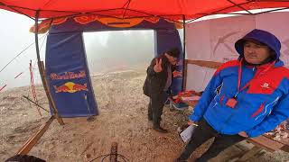
Open as of Mar 25, 2026Local Trail Association
Stats
- Avg Trail Rating
- Trails (view details)
- 91
- Trails Mountain Bike
- 92
- Trails E-Bike
- 74
- Trails Horse
- 29
- Trails Hike
- 80
- Trails Trail Running
- 82
- Trails Dirtbike/Moto
- 37
- Trails Observed Trials
- 9
- Trails ATV/ORV/OHV
- 40
- Trails Snowmobile
- 3
- Trails Snowshoe
- 3
- Trails Downhill Ski
- 3
- Trails Backcountry Ski
- 3
- Trails Nordic Ski
- 3
- Total Distance
- 119 miles
- Total Descent
- 27,767 ft
- Total Vertical
- 4,490 ft
- Highest Trailhead
- 6,125 ft
- Reports
- 66
- Photos
- 76
- Ridden Counter
- 844
Sub Regions
-
Bjelašnica
- 7
- 2
- 2
-
Bukovik
- 9
- 1
-
Igman
- 9
- 21
- 9
- 1
Popular Sarajevo Mountain Biking Trails
• 100 ★ 5.0 • 433 ft • 0 ft • 24 •
Popular blue difficulty singletrack. This mountain bike primary trail can be used both directions and has a moderate overall physical rating with a 0 ft blue climb. Trail visibility is always easy to follow. On average it takes 1 minutes to complete this trail.
• 90 ★ 0.0 • 3 miles • 1,066 ft • 16 •
Popular green difficulty family friendly dirt/gravel road. This mountain bike primary trail can be used both directions and has a moderate overall physical rating with a 1,066 ft blue climb. Trail visibility is always easy to follow. A license is required to use this trail.
• 80 ★ 5.0 • 2,172 ft • 33 ft • 15 •
Popular green difficulty dirt/gravel road. This mountain bike primary trail can be used downhill primary and has a easy overall physical rating with a 33 ft green climb. Trail visibility is always easy to follow. On average it takes 12 minutes to complete this trail. A license is required to use this trail.
• 55 ★ 4.4 • 2 miles • 0 ft • 14 •
Moderately popular black diamond difficulty singletrack. This mountain bike primary trail can be used downhill only and has a moderate overall physical rating with a 0 ft blue climb. It features rock face and skinny. Trail visibility is sometimes hard to follow. On average it takes 14 minutes to complete this trail.
• 70 ★ 5.0 • 2 miles • 100 ft • 12 •
Popular green difficulty dirt/gravel road. This multi-use trail can be used downhill primary and has a easy overall physical rating with a 100 ft green climb. Trail visibility is always easy to follow. On average it takes 7 minutes to complete this trail.
• 70 ★ 5.0 • 2 miles • 114 ft • 12 •
Popular blue difficulty singletrack. This mountain bike primary trail can be used downhill primary. It features rock face. On average it takes 14 minutes to complete this trail.
• 5 ★ 0.0 • 1 mile • 15 ft • 10 •
The middle of the road is reserved for pedestrians and carriages. On the left and right, the narrow path is great for MTB rides
Sarajevo Mountain Bike Routes
★ 5.0 • 25 miles • 4,050 ft • 4 • Loop •
MTB Marathon is a route that combines history, physical challenge, and absolute isolation in nature. This...
★ 5.0 • 30 miles • 4,233 ft • 7 • Loop •
iznzanredna ruta od babinog dola
★ 5.0 • 6 miles • 1,158 ft • 0 • Point to Point •
small trail, 10 km lenghts. The descent to Stojecevac is more than excellent.
34 miles • 3,902 ft • 0 • Point to Point •
Riding three mountains is a beautiful cycling route that stretches from via Bjelasnica and Treskavica.
34 miles • 4,620 ft • 0 • Loop •
Bjelašnica – – Blatca MTB Marathon Experience the rugged beauty of the Dinaric Alps on this epic...
Photos of Sarajevo Mountain Bike
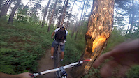
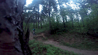
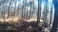
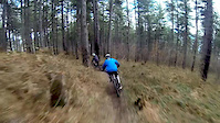
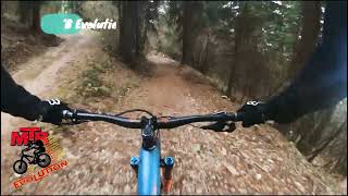
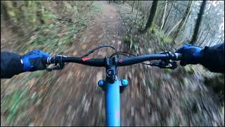
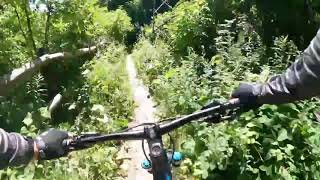
Videos of Sarajevo Mountain Bike
trail: Pashino Hill(Brza)
0:39 |
89 |
May 21, 2015
trail: Pashino Hill(Brza)
0:07 |
55 |
May 19, 2015
trail: Pashino Hill(Brza)
0:05 |
400 |
Apr 6, 2015
trail: Pashino Hill(Brza)
0:48 |
403 |
Mar 2, 2015
trail: Bijala DH
3:57 |
255 |
Sep 26, 2023 , Sarajevo
trail: Igman - Stojcevac
4:59 |
353 |
Mar 19, 2022 , Sarajevo
trail: Igman - Stojcevac
6:49 |
159 |
Jan 2, 2022 , Sarajevo
trail: Javorov Do trail
2:13 |
233 |
Nov 14, 2021 , Sarajevo
Recent Trail Reports
| status | trail | date | condition | info | user |
|---|---|---|---|---|---|
| Igman - Stojcevac | Feb 12, 2026 @ 2:26pm (Europe/Sarajevo) Feb 12, 2026 | Unknown | marko-ristivojevic-evolution MTB Evolution | ||
| Velika Aleja | Feb 5, 2024 @ 4:04am Feb 5, 2024 | Unknown | marko-ristivojevic-evolution MTB Evolution | ||
| Stojcevac | Feb 5, 2024 @ 4:04am Feb 5, 2024 | Ideal | marko-ristivojevic-evolution MTB Evolution | ||
| Bijala DH | Sep 24, 2023 @ 5:34am Sep 24, 2023 | Wet | LakhovAndrey SERBIA | ||
| Igmanska cesta | Apr 30, 2023 @ 11:54pm Apr 30, 2023 | Variable | Pityuka | ||
| Igmanska cesta | Apr 30, 2023 @ 11:54pm Apr 30, 2023 | Variable | Pityuka | ||
| Igmaniska cesta | Apr 30, 2023 @ 11:54pm Apr 30, 2023 | Wet | Pityuka | ||
| Igmanska cesta | Apr 30, 2023 @ 11:54pm Apr 30, 2023 | Wet | Pityuka | ||
| Igmanska Cesta | Apr 30, 2023 @ 11:54pm Apr 30, 2023 | Wet | Pityuka | ||
| Igmanska cesta | Apr 30, 2023 @ 11:54pm Apr 30, 2023 | Wet | Pityuka |
Activity Feed
| username | action | type | title | date |
|---|---|---|---|---|
| marko-ristivojevic-evolution | add | route | activity #95162635 | May 21, 2026 @ 2:31am May 21, 2026 |
| marko-ristivojevic-evolution | add | photo | activity #90606213 | Mar 14, 2026 @ 11:53pm Mar 14, 2026 |
| marko-ristivojevic-evolution | update | route | activity #90605891 | Mar 14, 2026 @ 11:32pm Mar 14, 2026 |
| marko-ristivojevic-evolution | update | route | activity #90531988 | Mar 13, 2026 @ 11:44pm Mar 13, 2026 |
| marko-ristivojevic-evolution | update | region | activity #90531904 | Mar 13, 2026 @ 11:40pm Mar 13, 2026 |
Recent Comments
| username | type | title | comment | date |
|---|---|---|---|---|
| trail | Extremely rocky. Fast and the thec | Jul 29, 2021 @ 12:10pm Jul 29, 2021 | ||
| trail | One of the best trails around Sarajevo so long. | Oct 19, 2019 @ 5:21am Oct 19, 2019 | ||
| trail | Trail heavily damaged by harvesters... | Oct 19, 2019 @ 5:20am Oct 19, 2019 |
Local Badges
-
Igman4 awarded -

10 Blue Trails4 awarded -

Epic Ride Climb 2k57 awarded -

Climbing 10k Badge12 awarded -

Climbing 100k Badge2 awarded -

Epic Ride Descent 2k59 awarded
Activity Type Stats
| activitytype | trails | distance | descent | descent distance | total vertical | rating | global rank | state rank | photos | reports | routes | ridelogs |
|---|---|---|---|---|---|---|---|---|---|---|---|---|
| Mountain Bike | 92 | 119 miles | 27,766 ft | 65 miles | 4,491 ft | #923 | #2 | 75 | 65 | 9 | 1,649 | |
| E-Bike | 74 | 104 miles | 23,921 ft | 57 miles | 3,560 ft | #427 | #3 | 1 | 59 | 5 | 64 | |
| Horse | 29 | 51 miles | 7,320 ft | 24 miles | 3,560 ft | #231 | #4 | 15 | ||||
| Hike | 80 | 107 miles | 24,419 ft | 59 miles | 3,563 ft | #1,047 | #4 | 64 | 1 | 293 | ||
| Trail Running | 82 | 108 miles | 24,511 ft | 59 miles | 3,563 ft | #745 | #2 | 64 | 1 | 107 | ||
| Dirtbike/Moto | 37 | 55 miles | 7,579 ft | 26 miles | 3,560 ft | #176 | #2 | 17 | 1 | |||
| Observed Trials | 9 | 7 miles | 266 ft | 1 mile | 1,867 ft | #104 | #2 | |||||
| ATV/ORV/OHV | 40 | 55 miles | 7,051 ft | 25 miles | 3,560 ft | #94 | #2 | 16 | 1 | |||
| Snowmobile | 3 | 1 mile | 75 ft | 2,684 ft | 59 ft | |||||||
| Snowshoe | 3 | 1 mile | 75 ft | 2,684 ft | 59 ft | 1 | ||||||
| Downhill Ski | 3 | 1 mile | 75 ft | 2,684 ft | 59 ft | 1 | 75 | |||||
| Backcountry Ski | 3 | 1 mile | 75 ft | 2,684 ft | 59 ft | 1 | 143 | |||||
| Nordic Ski | 3 | 1 mile | 75 ft | 2,684 ft | 59 ft | 1 | 9 |
Frequently Asked Questions About Sarajevo
▼
What are the best places to ride in Sarajevo?
Sarajevo has 3 areas to explore for mountain biking. The top rated areas are:
▼
What are the highest rated mountain biking trails in Sarajevo?
The highest rated mountain biking trails in Sarajevo are:
- Bijala DH (4.2/5)
- Nanica Put (4.2/5)
- Bone Fracture Trail (4.2/5)
- Bukovik Singletrack (4.2/5)
- Crepoljsko Trail (4.2/5)
▼
What is the best time of the year to ride in Sarajevo?
Based on ride log data, the most popular months to ride in Sarajevo are:
- May (23 activities)
- July (16 activities)
- August (15 activities)
▼
Where can I park to ride in Sarajevo?
Activities
Trails
- By marko-ristivojevic-evolution
 MTB Evolution PD Trebevic & contributors
 - Admins: marko-ristivojevic-evolution
- #7168 - 11,188 views
- sarajevo activity log | embed map of Sarajevo mountain bike trails | sarajevo mountain biking points of interest
Downloading of trail gps tracks in kml & gpx formats is enabled for Sarajevo.
You must login to download files.