close
-
Layers w
- Weather Layers
- Pro
- Pro
- Pro
- Pro
- Pro
- Pro
- More Layers
- Pro
- Pro
- Pro
- Pro
-
Upgrade to

3D
Trail Conditions
- Unknown
- Snow Groomed
- Snow Packed
- Snow Covered
- Snow Cover Partial
- Freeze/thaw Cycle
- Icy
- Prevalent Mud
- Wet
- Variable
- Ideal
- Dry
- Very Dry
Trail Flow (Ridden Direction)
Trailforks scans users ridelogs to determine the most popular direction each trail is ridden. A good flowing trail network will have most trails flowing in a single direction according to their intension.
The colour categories are based on what percentage of riders are riding a trail in its intended direction.
The colour categories are based on what percentage of riders are riding a trail in its intended direction.
- > 96%
- > 90%
- > 80%
- > 70%
- > 50%
- < 50%
- bi-directional trail
- no data
Trail Last Ridden
Trailforks scans ridelogs to determine the last time a trail was ridden.
- < 2 days
- < 1 week
- < 2 weeks
- < 1 month
- < 6 months
- > 6 months
Trail Ridden Direction
The intended direction a trail should be ridden.
- Downhill Only
- Downhill Primary
- Both Directions
- Uphill Primary
- Uphill Only
- One Direction
Contribute Details
Colors indicate trail is missing specified detail.
- Description
- Photos
- Description & Photos
- Videos
Trail Popularity ?
Trailforks scans ridelogs to determine which trails are ridden the most in the last 9 months.
Trails are compared with nearby trails in the same city region with a possible 25 colour shades.
Think of this as a heatmap, more rides = more kinetic energy = warmer colors.
- most popular
- popular
- less popular
- not popular
ATV/ORV/OHV Filter
Max Vehicle Width
inches
US Cell Coverage
Legend

Radar Time
Activity Recordings
Trailforks uses anonymized public activity data.
?
Activity Recordings
Trailforks uses anonymized public activity data.
?
Personal Heatmap
▶
Activity Types
all
/
none
▶
Options
2
Date range
month
–
Winter Trails
Warning
A routing network for winter maps does not exist. Selecting trails using the winter trails layer has been disabled.
Missing Trails
Most Popular
Least Popular
Trails are colored based on popularity. The more popular a trail is, the more red. Less popular trails trend towards green.
Jump Magnitude Heatmap
Heatmap of where riders jump on trails. Zoom in to see individual jumps, click circles to view jump details.
BC Backroad Status
![map legend]()
Service Road Atlas is a free to use, community-driven service for viewing and creating reports on the numerous back-country service roads around B.C. and Alberta.

Slope Aspect
Direction the slope faces
Trails Deemphasized
Trails are shown in grey.
Only show trails with no bike usage.
Suggested Layers
Based on selected activity type
Save the current map location and zoom level as your default home location whenever this page is loaded.
Save
No description for Sasbachwalden has been added yet!
Login or register to submit one.
This region uses the Uk/Euro style trail grading system.
Activities Click to view
- Mountain Bike
18 trails
- E-Bike
19 trails
- Winter Fat Bike
0 trails
- Hike
15 trails
- Trail Running
15 trails
Region Details
- 2
- 11
- 2
Region Status
Open as of Apr 18, 2026Local Trail Association
Stats
- Avg Trail Rating
- Trails (view details)
- 17
- Trails Mountain Bike
- 18
- Trails E-Bike
- 19
- Trails Hike
- 15
- Trails Trail Running
- 15
- Trails Nordic Ski
- 2
- Total Distance
- 20 miles
- Total Descent
- 6,345 ft
- Total Vertical
- 3,156 ft
- Highest Trailhead
- 3,820 ft
- Reports
- 81
- Photos
- 55
- Ridden Counter
- 1,392
Sub Regions
-
Schaeffler MTB-Arena
- 1
- 6
- 2
Popular Sasbachwalden Mountain Biking Trails
• 90 ★ 4.8 • 2 miles • 29 ft • 418 •
Der Alpirsbacher Klosterbräu in Sasbachwalden ist ein gebauter, flowiger Singetrail und mit einer Länge von vier Kilometern, einer der längsten präparierten Mountainbiketrails in Deutschland. Die speziell gebaute Trailstrecke...
• 100 ★ 4.7 • 3,003 ft • 2 ft • 320 •
r ist für jeden geübten Mountainbiker befahrbar. Die Strecke wurde bewusst als flowiger Spaßtrail angelegt. Der Trail hat nur mäßiges Gefälle, wenig Wurzeln oder Steinfelder. Viele Tables und Wellen versprechen Airtime und...
• 80 ★ 3.4 • 1 mile • 103 ft • 269 •
Tha majority of the trail is either flat or uphill. A couple of features on the downhill parts though.
• 70 ★ 3.7 • 2 miles • 0 ft • 103 •
The upper part of the Sasbach-Trails (Pfad Three) First section: Down from the windmill there are rocky steps, rudimentary simplified, not easy to ride. Second section: A bit easier after crossing the tarmac road, but still not easy....
• 20 ★ 3.5 • 2 miles • 137 ft • 22 •
Less popular blue difficulty singletrack. This mountain bike primary trail can be used both directions. On average it takes 15 minutes to complete this trail.
• 40 ★ 0.0 • 3,832 ft • 0 ft • 10 •
From "Kleine Grinde" down to B500 Passing a Moor over Rock-Plates, then stony doubletrack, through the wood, singletrack, roots, swampy parts.
• 30 ★ 0.0 • 2,067 ft • 0 ft • 7 •
Less popular blue difficulty singletrack. This multi-use trail can be used downhill primary and has a easy overall physical rating with a 0 ft green climb. It features bridge. Trail visibility is always easy to follow. On average it takes 4 minutes to complete this trail.
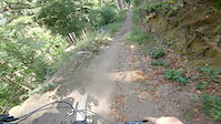
Photos of Sasbachwalden Mountain Bike
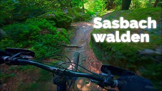
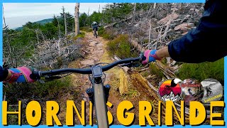
Videos of Sasbachwalden Mountain Bike
trail: Pfad Zwo
0:39 |
144 |
Aug 22, 2020
0:22 |
113 |
Aug 13, 2020

2:25 |
203 |
Oct 15, 2019

2:06 |
3015 |
Jul 27, 2018
youtuber
![SASBACHWALDEN Rumpelstielzchen & Statera...]()

trail: Rumpelstielzchen
21:32 |
193 |
Aug 29, 2025 , Sasbachwalden
trail: Pfad Zwo
11:06 |
71 |
Jul 4, 2025 , Sasbachwalden

11:06 |
120 |
Jul 4, 2025 , Sasbachwalden
youtuber
![Rumpelstielzchen und Alpirsbacher...]()
trail: Rumpelstielzchen
6:43 |
213 |
Mar 30, 2024 , Sasbachwalden
Recent Trail Reports
| status | trail | date | condition | info | user |
|---|---|---|---|---|---|
| Alpirsbacher Schwarzwaldtrail | Apr 18, 2026 @ 4:16pm (Europe/Busingen) Apr 18, 2026 | Ideal | danielschafer | ||
| Pfad Zwo | Apr 18, 2026 @ 4:16pm (Europe/Busingen) Apr 18, 2026 | Ideal | danielschafer | ||
| Kroppenkopf | Sep 12, 2025 @ 2:10pm (Europe/Berlin) Sep 12, 2025 | Wet | Michi794 | ||
| Connector to Schwarzwaldtrail | Nov 4, 2023 @ 8:23am Nov 4, 2023 | Variable | blub-m | ||
| Rumpelstielzchen | Oct 29, 2022 @ 2:15am Oct 29, 2022 | Ideal | Bushpaddler | ||
| Connector to Schwarzwaldtrail | Apr 18, 2022 @ 3:55am Apr 18, 2022 | Dry | BeneForst |
Activity Feed
| username | action | type | title | date |
|---|---|---|---|---|
| clemz | ridden | trail | activity #95859271 | May 30, 2026 @ 9:12am May 30, 2026 |
| clemz | ridden | trail | activity #95859236 | May 30, 2026 @ 9:12am May 30, 2026 |
| Aleximus | add | photo | activity #95763110 and 9 more | May 29, 2026 @ 2:20am May 29, 2026 |
| Aleximus | vote | trail | activity #95763077 | May 29, 2026 @ 2:18am May 29, 2026 |
| Aleximus | ridden | trail | activity #95763065 and 1 more | May 29, 2026 @ 2:18am May 29, 2026 |
Recent Comments
| username | type | title | comment | date |
|---|---|---|---|---|
| trail | In my opinion this trail is overrated. It has... | May 2, 2025 @ 9:37pm May 2, 2025 | ||
| trail | War einer meiner Lieblingstrails im... | Nov 1, 2023 @ 10:49am Nov 1, 2023 | ||
| trail | Ja, ist "schwierig" und sollte rot sein,... | Oct 9, 2022 @ 1:51pm Oct 9, 2022 | ||
| trail | Ä | Sep 10, 2022 @ 2:57pm Sep 10, 2022 | ||
| trail | Welcher dulli hat dem trail bitte 1 Stern... | Dec 19, 2020 @ 10:03am Dec 19, 2020 |
Local Badges
-

Epic Mountain Bike Climb 2k0 awarded -

Climbing 10k Badge0 awarded -

Mountain Biking 100k Badge0 awarded -

Epic Ride Descent 2k0 awarded -

Descent 10k Badge0 awarded -

Descent 100k Badge0 awarded
Activity Type Stats
| activitytype | trails | distance | descent | descent distance | total vertical | rating | global rank | state rank | photos | reports | routes | ridelogs |
|---|---|---|---|---|---|---|---|---|---|---|---|---|
| Mountain Bike | 18 | 10 miles | 5,213 ft | 8 miles | 3,156 ft | #4,988 | #111 | 54 | 79 | 1,808 | ||
| E-Bike | 19 | 20 miles | 6,345 ft | 13 miles | 3,156 ft | #3,975 | #103 | 1 | 66 | 244 | ||
| Hike | 15 | 6 miles | 3,734 ft | 6 miles | 3,156 ft | #8,066 | #141 | 59 | 293 | |||
| Trail Running | 15 | 6 miles | 3,734 ft | 6 miles | 3,156 ft | #7,699 | #145 | 59 | 3 | |||
| Nordic Ski | 2 | 10 miles | 1,132 ft | 5 miles | 492 ft | 36 |
Frequently Asked Questions About Sasbachwalden
▼
What are the best places to ride in Sasbachwalden?
Sasbachwalden has 1 areas to explore for mountain biking. The top rated areas are:
▼
What are the highest rated mountain biking trails in Sasbachwalden?
The highest rated mountain biking trails in Sasbachwalden are:
- Alpirsbacher Schwarzwaldtrail (4.6/5)
- Pfad Zwo (4.5/5)
- Rumpelstielzchen (3.8/5)
- Bocktrail (3.6/5)
- Connector to Schwarzwaldtrail (3.6/5)
▼
What is the best time of the year to ride in Sasbachwalden?
Based on ride log data, the most popular months to ride in Sasbachwalden are:
- August (20 activities)
- April (13 activities)
- May (11 activities)
▼
Where can I park to ride in Sasbachwalden?
There are 1 parking locations listed in Sasbachwalden. The most popular parking spots are:
Activities
Trails
Points of Interest
- By Icemanwb & contributors
- Admins: HDRiders, Sasse82, sp00n82, martywis
- #20704 - 3,634 views
- sasbachwalden activity log | embed map of Sasbachwalden mountain bike trails | sasbachwalden mountain biking points of interest
Downloading of trail gps tracks in kml & gpx formats is enabled for Sasbachwalden.
You must login to download files.