close
-
Layers w
- Weather Layers
- Pro
- Pro
- Pro
- Pro
- Pro
- Pro
- More Layers
- Pro
- Pro
- Pro
- Pro
-
Upgrade to

3D
Trail Conditions
- Unknown
- Snow Groomed
- Snow Packed
- Snow Covered
- Snow Cover Partial
- Freeze/thaw Cycle
- Icy
- Prevalent Mud
- Wet
- Variable
- Ideal
- Dry
- Very Dry
Trail Flow (Ridden Direction)
Trailforks scans users ridelogs to determine the most popular direction each trail is ridden. A good flowing trail network will have most trails flowing in a single direction according to their intension.
The colour categories are based on what percentage of riders are riding a trail in its intended direction.
The colour categories are based on what percentage of riders are riding a trail in its intended direction.
- > 96%
- > 90%
- > 80%
- > 70%
- > 50%
- < 50%
- bi-directional trail
- no data
Trail Last Ridden
Trailforks scans ridelogs to determine the last time a trail was ridden.
- < 2 days
- < 1 week
- < 2 weeks
- < 1 month
- < 6 months
- > 6 months
Trail Ridden Direction
The intended direction a trail should be ridden.
- Downhill Only
- Downhill Primary
- Both Directions
- Uphill Primary
- Uphill Only
- One Direction
Contribute Details
Colors indicate trail is missing specified detail.
- Description
- Photos
- Description & Photos
- Videos
Trail Popularity ?
Trailforks scans ridelogs to determine which trails are ridden the most in the last 9 months.
Trails are compared with nearby trails in the same city region with a possible 25 colour shades.
Think of this as a heatmap, more rides = more kinetic energy = warmer colors.
- most popular
- popular
- less popular
- not popular
ATV/ORV/OHV Filter
Max Vehicle Width
inches
US Cell Coverage
Legend

Radar Time
Activity Recordings
Trailforks uses anonymized public activity data.
?
Activity Recordings
Trailforks uses anonymized public activity data.
?
Personal Heatmap
▶
Activity Types
all
/
none
▶
Options
2
Date range
month
–
Winter Trails
Warning
A routing network for winter maps does not exist. Selecting trails using the winter trails layer has been disabled.
Missing Trails
Most Popular
Least Popular
Trails are colored based on popularity. The more popular a trail is, the more red. Less popular trails trend towards green.
Jump Magnitude Heatmap
Heatmap of where riders jump on trails. Zoom in to see individual jumps, click circles to view jump details.
BC Backroad Status
![map legend]()
Service Road Atlas is a free to use, community-driven service for viewing and creating reports on the numerous back-country service roads around B.C. and Alberta.

Slope Aspect
Direction the slope faces
Trails Deemphasized
Trails are shown in grey.
Only show trails with no bike usage.
Suggested Layers
Based on selected activity type
Save the current map location and zoom level as your default home location whenever this page is loaded.
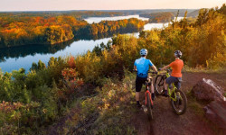
SaveSavage is a suburban city 15 miles (24 km) south-southwest of downtown Minneapolis in Scott County in the U.S. state of Minnesota. The city is on the south bank of the Minnesota River in a region commonly called South of the River, comprising the southern portion of Minneapolis-St. Paul, the 16th-largest metropolitan area in the United States. The population of Savage was 32,465 at the 2020 census.
source: Wikipedia
Activities Click to view
- Mountain Bike
14 trails
- E-Bike
6 trails
- Winter Fat Bike
0 trails
- Horse
31 trails
- Hike
61 trails
- Trail Running
60 trails
- Dirtbike/Moto
0 trails
- Observed Trials
0 trails
- ATV/ORV/OHV
0 trails
- Snowmobile
0 trails
- Snowshoe
0 trails
- Downhill Ski
0 trails
- Backcountry Ski
0 trails
- Nordic Ski
35 trails
Region Details
- 1
- 4
- 5
- 1
- 3
Region Status
Open as of Oct 18, 2025Local Trail Association
Stats
- Avg Trail Rating
- Trails (view details)
- 62
- Trails Mountain Bike
- 14
- Trails E-Bike
- 6
- Trails Horse
- 31
- Trails Hike
- 61
- Trails Trail Running
- 60
- Trails Nordic Ski
- 35
- Total Distance
- 29 miles
- Total Descent
- 1,448 ft
- Total Vertical
- 163 ft
- Highest Trailhead
- 1,046 ft
- Reports
- 400
- Photos
- 39
- Ridden Counter
- 11,680
Articles
The Best Mountain Biking in Minnesota
Aug 22, 2024 from outsideonline.com
World-class riding is the state’s best-kept secret. These are the top trails, according to a local expert.
Sub Regions
-
Murphy-Hanrehan Park
- 4
- 5
- 2
Popular Savage Mountain Biking Trails
• 95 ★ 3.6 • 1 mile • 83 ft • 1,149 •
This trail is marked as intermediate, but I think that is relative to the trail system. It really lands more in between easy and intermediate on account of some fast sections and a few quick turns with some rooty areas. But most the...
• 80 ★ 3.8 • 1 mile • 63 ft • 1,149 •
This is very similar to the start, buff and smooth singletrack. This section includes the little intermediate cutoff section to the intersection and then straight onto the finish. The last little straightaway can be pretty fast with a...
• 65 ★ 3.3 • 3,510 ft • 18 ft • 1,129 •
Not sure if this really should be blue, it is buff and a fast return. If you pedal hard through the transitions and little ups, you can get back fast.
• 100 ★ 2.5 • 1,309 ft • 12 ft • 1,111 •
Butter smooth with a little bump on the way down. This is the main one-way entrance to the trail system that takes you across a meadow and then hits a fork. Take the left into the forest to start on the intermediate trail or loop it...
• 45 ★ 5.0 • 308 ft • 3 ft • 874 •
High narrow skinny. If you are clipped in and fall, it could be a nasty hit to your body and arms. Fun feature though, that you can loop multiple times if you like.
• 40 ★ 0.0 • 371 ft • 0 ft • 745 •
Maybe not double black diamond, but if you don't take the cheater line this rocky sections is really difficult to climb. You need good cardio to punch it, and you need to clear your pedals of the rocks
• 75 ★ 4.0 • 2,881 ft • 45 ft • 693 •
You can short circuit the , or continue to do this little extension. This trail is very typical of all the easiest parts of the and similar to the intermediate loop. Don't miss the cool little optional line at the end. You can really...
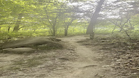
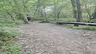
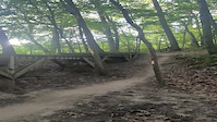
Photos of Savage Mountain Bike
Videos of Savage Mountain Bike
trail: Hard Loop
0:06 |
|
Jul 4, 2021
trail: Hard Loop
0:22 |
|
Jul 4, 2021
trail: Hard Loop
0:07 |
|
Jul 4, 2021
trail: Hard Loop
18:12 |
314 |
Oct 2, 2023 , Savage
trail: Prairie to Exit
9:17 |
160 |
Sep 21, 2023 , Savage

trail: Intermediate to Hard
9:17 |
185 |
Sep 21, 2023 , Savage

trail: Trailhead to Forest
9:17 |
214 |
Sep 21, 2023 , Savage

trail: 2022 Trail Addition
10:36 |
329 |
Jun 20, 2023 , Savage
Recent Trail Reports
| status | trail | date | condition | info | user |
|---|---|---|---|---|---|
| Hard Loop | Oct 18, 2025 @ 8:41am (America/Chicago) Oct 18, 2025 | Dry | Robinsos79 | ||
| Intermediate Exit | Sep 28, 2025 @ 11:55am (America/Menominee) Sep 28, 2025 | Dry | CrazyIvan21 | ||
| Intermediate to Hard | Sep 28, 2025 @ 11:55am (America/Menominee) Sep 28, 2025 | Dry | CrazyIvan21 | ||
| Trailhead to Forest | Sep 28, 2025 @ 11:55am (America/Menominee) Sep 28, 2025 | Dry | CrazyIvan21 | ||
| Parking Access | Aug 5, 2025 @ 6:08pm Aug 5, 2025 | Dry | Rockyroads33 | ||
| Prairie to Exit | Aug 5, 2025 @ 6:08pm Aug 5, 2025 | Dry | Rockyroads33 | ||
| Skills Loop | Aug 5, 2025 @ 6:08pm Aug 5, 2025 | Dry | Rockyroads33 | ||
| 2022 Trail Addition | Jul 12, 2025 @ 9:22am Jul 12, 2025 | Ideal | jcbreck | ||
| High Skinny | Jul 12, 2025 @ 9:22am Jul 12, 2025 | Ideal | jcbreck | ||
| Easy Cutoff | Sep 5, 2024 @ 9:30am Sep 5, 2024 | Ideal | Kurt8wFjYX |
Activity Feed
| username | action | type | title | date |
|---|---|---|---|---|
| TrieBWkWf | wishlist | region | activity #97860613 | Jun 26, 2026 @ 3:28pm Jun 26, 2026 |
| Yojeffchuck | ridden | trail | activity #95562137 | May 26, 2026 @ 7:05am May 26, 2026 |
| JoeWagner | add | photo | activity #95518888 | May 25, 2026 @ 1:28pm May 25, 2026 |
| grilled672 | ridden | trail | activity #94567897 and 2 more | May 12, 2026 @ 10:15am May 12, 2026 |
| pindarthered | vote | trail | activity #94061604 and 3 more | May 4, 2026 @ 5:42pm May 4, 2026 |
Recent Comments
| username | type | title | comment | date |
|---|---|---|---|---|
| trail | This loop is longer, therefore it will take... | Oct 31, 2021 @ 8:52am Oct 31, 2021 |
Local Badges
-

Epic Ride Climb 2k3 awarded -

Climbing 10k Badge32 awarded -

Climbing 100k Badge1 awarded -

Epic Ride Descent 2k3 awarded -

Descent 10k Badge33 awarded -

Descent 100k Badge2 awarded
Activity Type Stats
| activitytype | trails | distance | descent | descent distance | total vertical | rating | global rank | state rank | photos | reports | routes | ridelogs |
|---|---|---|---|---|---|---|---|---|---|---|---|---|
| Mountain Bike | 14 | 10 miles | 617 ft | 4 miles | 115 ft | #1,908 | #696 | 39 | 399 | 10,748 | ||
| E-Bike | 6 | 4 miles | 151 ft | 1 mile | 52 ft | #8,766 | #2,677 | 379 | 147 | |||
| Horse | 31 | 12 miles | 486 ft | 5 miles | 112 ft | #2,261 | #1,255 | 35 | 1 | |||
| Hike | 61 | 29 miles | 1,444 ft | 10 miles | 164 ft | #6,116 | #2,148 | 400 | 221 | |||
| Trail Running | 60 | 28 miles | 1,434 ft | 10 miles | 164 ft | #5,510 | #1,742 | 398 | 243 | |||
| Nordic Ski | 35 | #1,514 | #735 | 3 |
Frequently Asked Questions About Savage
▼
What are the best places to ride in Savage?
Savage has 1 areas to explore for mountain biking. The top rated areas are:
▼
What are the highest rated mountain biking trails in Savage?
The highest rated mountain biking trails in Savage are:
- Hard Loop (4.4/5)
- High Skinny (4.1/5)
- Prairie to Exit (4.1/5)
- Intermediate to Hard (3.8/5)
- Intermediate Exit (3.8/5)
▼
What is the best time of the year to ride in Savage?
Based on ride log data, the most popular months to ride in Savage are:
- August (102 activities)
- July (95 activities)
- September (87 activities)
▼
Where can I park to ride in Savage?
There are 4 parking locations listed in Savage. The most popular parking spots are: View all parking and trailhead locations on the map to plan your visit.
Activities
Trails
Points of Interest
- By namdoogttam
 COGGS TRAILFORKS COGGS & contributors
 - Admins: apply
- #7645 - 4,259 views
- savage activity log | embed map of Savage mountain bike trails | savage mountain biking points of interest
Downloading of trail gps tracks in kml & gpx formats is enabled for Savage.
You must login to download files.