close
-
Layers w
- Weather Layers
- Pro
- Pro
- Pro
- Pro
- Pro
- Pro
- More Layers
- Pro
- Pro
- Pro
- Pro
-
Upgrade to

3D
Trail Conditions
- Unknown
- Snow Groomed
- Snow Packed
- Snow Covered
- Snow Cover Partial
- Freeze/thaw Cycle
- Icy
- Prevalent Mud
- Wet
- Variable
- Ideal
- Dry
- Very Dry
Trail Flow (Ridden Direction)
Trailforks scans users ridelogs to determine the most popular direction each trail is ridden. A good flowing trail network will have most trails flowing in a single direction according to their intension.
The colour categories are based on what percentage of riders are riding a trail in its intended direction.
The colour categories are based on what percentage of riders are riding a trail in its intended direction.
- > 96%
- > 90%
- > 80%
- > 70%
- > 50%
- < 50%
- bi-directional trail
- no data
Trail Last Ridden
Trailforks scans ridelogs to determine the last time a trail was ridden.
- < 2 days
- < 1 week
- < 2 weeks
- < 1 month
- < 6 months
- > 6 months
Trail Ridden Direction
The intended direction a trail should be ridden.
- Downhill Only
- Downhill Primary
- Both Directions
- Uphill Primary
- Uphill Only
- One Direction
Contribute Details
Colors indicate trail is missing specified detail.
- Description
- Photos
- Description & Photos
- Videos
Trail Popularity ?
Trailforks scans ridelogs to determine which trails are ridden the most in the last 9 months.
Trails are compared with nearby trails in the same city region with a possible 25 colour shades.
Think of this as a heatmap, more rides = more kinetic energy = warmer colors.
- most popular
- popular
- less popular
- not popular
ATV/ORV/OHV Filter
Max Vehicle Width
inches
US Cell Coverage
Legend

Radar Time
Activity Recordings
Trailforks uses anonymized public activity data.
?
Activity Recordings
Trailforks uses anonymized public activity data.
?
Personal Heatmap
▶
Activity Types
all
/
none
▶
Options
2
Date range
month
–
Winter Trails
Warning
A routing network for winter maps does not exist. Selecting trails using the winter trails layer has been disabled.
Missing Trails
Most Popular
Least Popular
Trails are colored based on popularity. The more popular a trail is, the more red. Less popular trails trend towards green.
Jump Magnitude Heatmap
Heatmap of where riders jump on trails. Zoom in to see individual jumps, click circles to view jump details.
BC Backroad Status
![map legend]()
Service Road Atlas is a free to use, community-driven service for viewing and creating reports on the numerous back-country service roads around B.C. and Alberta.

Slope Aspect
Direction the slope faces
Trails Deemphasized
Trails are shown in grey.
Only show trails with no bike usage.
Suggested Layers
Based on selected activity type
Save the current map location and zoom level as your default home location whenever this page is loaded.
Save
No description for Scandicci has been added yet!
Login or register to submit one.
This region uses the Uk/Euro style trail grading system.
Activities Click to view
- Mountain Bike
9 trails
- E-Bike
6 trails
- Adaptive Bike
0 trails
- Winter Fat Bike
0 trails
- Hike
5 trails
- Trail Running
5 trails
Region Details
- 2
- 1
- 5
- 1
Region Status
Open as of Apr 4, 2026Stats
- Avg Trail Rating
- Trails (view details)
- 9
- Trails Mountain Bike
- 9
- Trails E-Bike
- 6
- Trails Horse
- 3
- Trails Hike
- 5
- Trails Trail Running
- 5
- Trails Dirtbike/Moto
- 2
- Total Distance
- 7 miles
- Total Descent
- 343 ft
- Total Vertical
- 1,078 ft
- Highest Trailhead
- 1,213 ft
- Reports
- 80
- Photos
- 1
- Ridden Counter
- 616
Popular Scandicci Mountain Biking Trails
• 45 ★ 4.4 • 5,123 ft • 401 ft • 73 •
Moderately popular green difficulty singletrack. This mountain bike primary trail can be used downhill only and has a moderate overall physical rating with a 401 ft green climb. Trail visibility is always easy to follow. On average it takes 12 minutes to complete this trail.
• 90 ★ 5.0 • 2,595 ft • 3 ft • 56 •
Popular blue difficulty singletrack. This mountain bike primary trail can be used downhill only. It features drop and jump.
• 75 ★ 4.0 • 1 mile • 254 ft • 50 •
Popular green difficulty mixed. This mountain bike primary trail can be used downhill primary. On average it takes 10 minutes to complete this trail.
• 5 ★ 5.0 • 1 mile • 0 ft • 30 •
Less popular white difficulty family friendly singletrack. This multi-use trail can be used both directions and has a easy overall physical rating. It features other. Trail visibility is always easy to follow. On average it takes 8 minutes to complete this trail.
• 30 ★ 0.0 • 1,683 ft • 25 ft • 20 •
Less popular green difficulty singletrack. This mountain bike primary trail can be used both directions with a 25 ft blue climb. Trail visibility is always easy to follow. On average it takes 1 minutes to complete this trail.
• 15 ★ 0.0 • 1,217 ft • 85 ft • 10 •
Less popular green difficulty singletrack. This mountain bike primary trail can be used one direction with a 85 ft green climb. Trail visibility is sometimes hard to follow. On average it takes 3 minutes to complete this trail.
• ★ 0.0 • 3 miles • 469 ft •
Buon giro per uscita veloce zona Scandicci. 3/4 in salita da Scandicci a Giogoli, poi ultima parte discesa divertente fino a Ponte all'Asse. Nice loop for a quick ride in the Scandicci area. 3/4 uphill from Scandicci to Giogoli, then a...
Scandicci Mountain Bike Routes
4 miles • 640 ft • 0 •
Percorso in fase di realizzazione, alcuni punti nel bosco, generalmente facile
Videos of Scandicci Mountain Bike
youtuber
![trenino in ROVETA sul Rochirod trail #mtb enduro]()
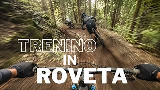
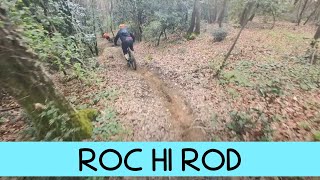
trail: ROC HI ROD
3:13 |
14 |
May 11, 2026 , Scandicci
youtuber
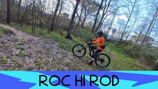
![MTB Roveta 28.03.2026 sentiero ROC HI ROD]()
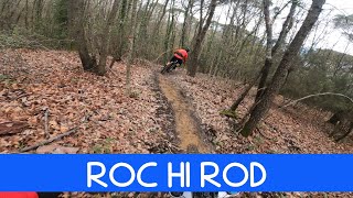
trail: ROC HI ROD
2:59 |
21 |
Mar 29, 2026 , Scandicci
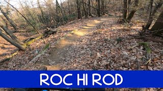
youtuber
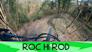
![Roc Hi Rod 28/3/26 Roveta]()
trail: ROC HI ROD
2:55 |
27 |
Mar 29, 2026 , Scandicci
youtuber
![MTB Roveta 21.02.2026 sentiero ROC HI ROD]()
trail: ROC HI ROD
3:14 |
30 |
Feb 21, 2026 , Scandicci
youtuber
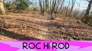
![è un sentiero facile adatto a tutti? ROCHIROD...]()

trail: ROC HI ROD
2:49 |
43 |
Feb 9, 2026 , Scandicci
youtuber
![MTB Roveta 29.03.2025 sentiero Roc Hi Rod]()
trail: ROC HI ROD
3:10 |
115 |
Mar 29, 2025 , Scandicci
youtuber
![MTB Roveta 29.03.2025 sentiero ROC HI ROD]()
trail: ROC HI ROD
3:15 |
87 |
Mar 29, 2025 , Scandicci
youtuber
![MTB Roveta 31.12.2024 sentiero ROC HI ROD]()
trail: ROC HI ROD
3:03 |
79 |
Dec 31, 2024 , Scandicci
Recent Trail Reports
| status | trail | date | condition | info | user |
|---|---|---|---|---|---|
| AR le pozze | Apr 4, 2026 @ 4:59pm (Europe/Rome) Apr 4, 2026 | Variable | oohdako | ||
| ROC HI ROD | Apr 4, 2026 @ 4:58pm (Europe/Rome) Apr 4, 2026 | Ideal | oohdako | ||
| Linea Paula | Mar 7, 2026 @ 9:39am (Europe/San_Marino) Mar 7, 2026 | Ideal | Nanno1977 | ||
| Scandicci to Roveta | Feb 28, 2026 @ 1:17pm (Europe/Rome) Feb 28, 2026 | Dry | Ginopilotino86 | ||
| La Cave | Oct 8, 2025 @ 9:22am (Europe/San_Marino) Oct 8, 2025 | Variable | gpaoloconti | ||
| Argine Le Fonti -Rinaldi | May 29, 2023 @ 4:09am May 29, 2023 | Dry | Pas63 | ||
| Voltage Alternative Lift | Mar 20, 2022 @ 12:26am Mar 20, 2022 | Dry | lucadip | ||
| Cancelli | Nov 7, 2020 @ 10:46pm Nov 7, 2020 | Variable | DrTesti |
Activity Feed
| username | action | type | title | date |
|---|---|---|---|---|
| trailforks | add | video | activity #94489964 | May 11, 2026 @ 6:00am May 11, 2026 |
| gimix2025 | ridden | trail | activity #92173900 | Apr 8, 2026 @ 4:01am Apr 8, 2026 |
| oohdako | add | report | activity #91897122 and 1 more | Apr 4, 2026 @ 7:58am Apr 4, 2026 |
| Niciz | wishlist | trail | activity #91780887 | Apr 2, 2026 @ 2:07pm Apr 2, 2026 |
| oohdako | wishlist | trail | activity #91511430 | Mar 29, 2026 @ 6:20am Mar 29, 2026 |
Activity Type Stats
| activitytype | trails | distance | descent | descent distance | total vertical | rating | global rank | state rank | photos | reports | routes | ridelogs |
|---|---|---|---|---|---|---|---|---|---|---|---|---|
| Mountain Bike | 9 | 7 miles | 344 ft | 2 miles | 1,079 ft | #7,786 | #677 | 1 | 80 | 1 | 2,150 | |
| E-Bike | 6 | 6 miles | 151 ft | 1 mile | 1,079 ft | #7,726 | #838 | 77 | 1 | 106 | ||
| Horse | 3 | 6 miles | 144 ft | 1 mile | 860 ft | 9 | 1 | |||||
| Hike | 5 | 7 miles | 338 ft | 2 miles | 869 ft | #11,908 | #880 | 79 | 67 | |||
| Trail Running | 5 | 7 miles | 338 ft | 2 miles | 869 ft | #11,400 | #871 | 79 | 1 | 18 | ||
| Dirtbike/Moto | 2 | 4 miles | 39 ft | 3,560 ft | 860 ft | 6 |
Frequently Asked Questions About Scandicci
▼
What are the highest rated mountain biking trails in Scandicci?
The highest rated mountain biking trails in Scandicci are:
- ROC HI ROD (4.1/5)
- Argine Le Fonti -Rinaldi (4.1/5)
- La Cave (4.1/5)
- AR le pozze (4/5)
- Cancelli (0/5)
▼
What is the best time of the year to ride in Scandicci?
Based on ride log data, the most popular months to ride in Scandicci are:
- October (7 activities)
- February (5 activities)
- May (3 activities)
▼
Where can I park to ride in Scandicci?
Check the Scandicci trail map for trailhead and parking information. Community members regularly update access and parking details for trails in the area.
▼
What is the longest trail in Scandicci?
The longest trail in Scandicci is Scandicci Alto-Ponte all'Asse at 3.0 miles. View all trails sorted by distance.
- By Isetblack
 & contributors
 - Admins: DanielePracchia
- #27910 - 1,419 views
- scandicci activity log | embed map of Scandicci mountain bike trails |
Downloading of trail gps tracks in kml & gpx formats is enabled for Scandicci.
You must login to download files.