close
-
Layers w
- Weather Layers
- Pro
- Pro
- Pro
- Pro
- Pro
- Pro
- More Layers
- Pro
- Pro
- Pro
- Pro
-
Upgrade to

3D
Trail Conditions
- Unknown
- Snow Groomed
- Snow Packed
- Snow Covered
- Snow Cover Partial
- Freeze/thaw Cycle
- Icy
- Prevalent Mud
- Wet
- Variable
- Ideal
- Dry
- Very Dry
Trail Flow (Ridden Direction)
Trailforks scans users ridelogs to determine the most popular direction each trail is ridden. A good flowing trail network will have most trails flowing in a single direction according to their intension.
The colour categories are based on what percentage of riders are riding a trail in its intended direction.
The colour categories are based on what percentage of riders are riding a trail in its intended direction.
- > 96%
- > 90%
- > 80%
- > 70%
- > 50%
- < 50%
- bi-directional trail
- no data
Trail Last Ridden
Trailforks scans ridelogs to determine the last time a trail was ridden.
- < 2 days
- < 1 week
- < 2 weeks
- < 1 month
- < 6 months
- > 6 months
Trail Ridden Direction
The intended direction a trail should be ridden.
- Downhill Only
- Downhill Primary
- Both Directions
- Uphill Primary
- Uphill Only
- One Direction
Contribute Details
Colors indicate trail is missing specified detail.
- Description
- Photos
- Description & Photos
- Videos
Trail Popularity ?
Trailforks scans ridelogs to determine which trails are ridden the most in the last 9 months.
Trails are compared with nearby trails in the same city region with a possible 25 colour shades.
Think of this as a heatmap, more rides = more kinetic energy = warmer colors.
- most popular
- popular
- less popular
- not popular
ATV/ORV/OHV Filter
Max Vehicle Width
inches
US Cell Coverage
Legend

Radar Time
Activity Recordings
Trailforks uses anonymized public activity data.
?
Activity Recordings
Trailforks uses anonymized public activity data.
?
Personal Heatmap
▶
Activity Types
all
/
none
▶
Options
2
Date range
month
–
Winter Trails
Warning
A routing network for winter maps does not exist. Selecting trails using the winter trails layer has been disabled.
Missing Trails
Most Popular
Least Popular
Trails are colored based on popularity. The more popular a trail is, the more red. Less popular trails trend towards green.
Jump Magnitude Heatmap
Heatmap of where riders jump on trails. Zoom in to see individual jumps, click circles to view jump details.
BC Backroad Status
![map legend]()
Service Road Atlas is a free to use, community-driven service for viewing and creating reports on the numerous back-country service roads around B.C. and Alberta.

Slope Aspect
Direction the slope faces
Trails Deemphasized
Trails are shown in grey.
Only show trails with no bike usage.
Suggested Layers
Based on selected activity type
Save the current map location and zoom level as your default home location whenever this page is loaded.
SaveSchëtterhaard is a forest located on a hill between the villages Schuttrange, Neuhaeusgen and Sandweiler.
Primary Trail Type: Cross-Country
Land Status: Community Forest
 google parking directions
 Activities Click to view
- Mountain Bike
5 trails
- Hike
5 trails
- Trail Running
5 trails
Region Details
- 4
- 1
Region Status
Open as of Apr 19, 2022Stats
- Avg Trail Rating
- Trails (view details)
- 5
- Trails Mountain Bike
- 5
- Trails E-Bike
- 1
- Trails Hike
- 5
- Trails Trail Running
- 5
- Total Distance
- 6 miles
- Total Descent
- 859 ft
- Total Vertical
- 431 ft
- Highest Trailhead
- 1,140 ft
- Reports
- 4
- Photos
- 6
- Ridden Counter
- 44
Popular Schëtterhaard Mountain Biking Trails
• 75 ★ 3.0 • 229 ft • 0 ft • 14 •
This short trail can be an alternative for a small part of the Schëtterhaard Trail 1. It's nice to ride and requires more of your technical skills.
• 90 ★ 0.0 • 1,395 ft • 157 ft • 11 •
Popular green difficulty singletrack. This mountain bike primary trail can be used uphill primary and has a moderate overall physical rating with a 157 ft green climb. On average it takes 5 minutes to complete this trail.
• 65 ★ 3.0 • 4,674 ft • 7 ft • 10 •
Schëtterhaard is a forest area near the village of Schuttrange. It has several trails that are used by hikers as well as bikers. Very few trails have names or are signposted. That's why a little help from the locals is useful. The...
• 25 ★ 3.0 • 4 miles • 668 ft • 8 •
Schëtterhaard is a forest area near the village of Schuttrange. It has several trails that are used by hikers as well as bikers. Very few trails have names or are signposted. That's why a little help from the locals is useful. The...
• 50 ★ 0.0 • 2,618 ft • 34 ft • 1 •
Moderately popular green difficulty singletrack. This mountain bike primary trail can be used downhill primary and has a easy overall physical rating with a 34 ft green climb. Trail visibility is always easy to follow.
Schëtterhaard Mountain Bike Routes
6 miles • 817 ft • 7 •
This route follows hiking trails in the forest. There is only a small part of paved road in the village of...
9 miles • 866 ft • 0 • Loop •
MTB-Strecke Grevenmacher Start: Potaschberg Der Rundweg steigt am Rande des Tals empor und durchquert die...
15 miles • 1,663 ft • 0 • Loop •
All 33 of the official Luxembourg mountain bike routes are extremely well-signed, using a white square...
Videos of Schëtterhaard Mountain Bike
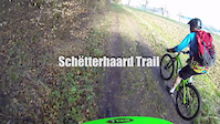
trail: Schëtterhaard Trail 1
5:56 |
206 |
Jun 7, 2015
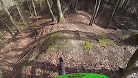
trail: Schëtterhaard Trail 4
0:19 |
121 |
Apr 13, 2015
Recent Trail Reports
| status | trail | date | condition | info | user |
|---|---|---|---|---|---|
| Schëtterhaard Trail 5 | Apr 19, 2022 @ 6:08am Apr 19, 2022 | Dry | BirkirOrn | ||
| Schëtterhaard Trail 1 | Feb 5, 2017 @ 8:01am Feb 5, 2017 | Wet | andresjerrero | ||
| Schëtterhaard Trail 4 | Apr 12, 2015 @ 6:26am Apr 12, 2015 | Dry | meylepa |
Activity Feed
| username | action | type | title | date |
|---|---|---|---|---|
| nerut | wishlist | region | activity #45229601 | Oct 14, 2023 @ 11:54am Oct 14, 2023 |
| BirkirOrn | wishlist | route | activity #35438177 | Nov 16, 2022 @ 11:20am Nov 16, 2022 |
| prolllo | add | trail | activity #32177022 | Aug 6, 2022 @ 12:05am Aug 6, 2022 |
| Jan-Albert | wishlist | route | activity #31043299 | Jul 4, 2022 @ 10:08am Jul 4, 2022 |
| BirkirOrn | add | report | activity #28519419 | Apr 19, 2022 @ 8:09am Apr 19, 2022 |
Nearby Areas
| name | distance | ||||
|---|---|---|---|---|---|
| Senningerbierg Forest | 2 | 1 | 1.9 km | ||
| Grengewald | 2 | 2.6 km | |||
| Berdorf Riding Area | 2 | 1 | 1 | 14.4 km | |
| Strossen / Bambech | 14.6 km | ||||
| Red Dirt | 2 | 4 | 14.9 km |
Activity Type Stats
| activitytype | trails | distance | descent | descent distance | total vertical | rating | global rank | state rank | photos | reports | routes | ridelogs |
|---|---|---|---|---|---|---|---|---|---|---|---|---|
| Mountain Bike | 5 | 6 miles | 860 ft | 2 miles | 430 ft | #12,074 | #8 | 6 | 4 | 3 | 294 | |
| E-Bike | 1 | 2,618 ft | 177 ft | 1,631 ft | 177 ft | 4 | 1 | |||||
| Hike | 5 | 6 miles | 860 ft | 2 miles | 430 ft | #2,234 | #5 | 4 | 8 | |||
| Trail Running | 5 | 6 miles | 860 ft | 2 miles | 430 ft | #1,540 | #5 | 4 | 9 |
- By meylepa & contributors
- Admins: Freischneider
- #4686 - 2,367 views
- schëtterhaard activity log | embed map of Schëtterhaard mountain bike trails | schëtterhaard mountain biking points of interest
Downloading of trail gps tracks in kml & gpx formats is enabled for Schëtterhaard.
You must login to download files.