close
-
Layers w
- Weather Layers
- Pro
- Pro
- Pro
- Pro
- Pro
- Pro
- More Layers
- Pro
- Pro
- Pro
- Pro
-
Upgrade to

3D
Trail Conditions
- Unknown
- Snow Groomed
- Snow Packed
- Snow Covered
- Snow Cover Partial
- Freeze/thaw Cycle
- Icy
- Prevalent Mud
- Wet
- Variable
- Ideal
- Dry
- Very Dry
Trail Flow (Ridden Direction)
Trailforks scans users ridelogs to determine the most popular direction each trail is ridden. A good flowing trail network will have most trails flowing in a single direction according to their intension.
The colour categories are based on what percentage of riders are riding a trail in its intended direction.
The colour categories are based on what percentage of riders are riding a trail in its intended direction.
- > 96%
- > 90%
- > 80%
- > 70%
- > 50%
- < 50%
- bi-directional trail
- no data
Trail Last Ridden
Trailforks scans ridelogs to determine the last time a trail was ridden.
- < 2 days
- < 1 week
- < 2 weeks
- < 1 month
- < 6 months
- > 6 months
Trail Ridden Direction
The intended direction a trail should be ridden.
- Downhill Only
- Downhill Primary
- Both Directions
- Uphill Primary
- Uphill Only
- One Direction
Contribute Details
Colors indicate trail is missing specified detail.
- Description
- Photos
- Description & Photos
- Videos
Trail Popularity ?
Trailforks scans ridelogs to determine which trails are ridden the most in the last 9 months.
Trails are compared with nearby trails in the same city region with a possible 25 colour shades.
Think of this as a heatmap, more rides = more kinetic energy = warmer colors.
- most popular
- popular
- less popular
- not popular
ATV/ORV/OHV Filter
Max Vehicle Width
inches
US Cell Coverage
Legend

Radar Time
Activity Recordings
Trailforks uses anonymized public activity data.
?
Activity Recordings
Trailforks uses anonymized public activity data.
?
Personal Heatmap
▶
Activity Types
all
/
none
▶
Options
2
Date range
month
–
Winter Trails
Warning
A routing network for winter maps does not exist. Selecting trails using the winter trails layer has been disabled.
Missing Trails
Most Popular
Least Popular
Trails are colored based on popularity. The more popular a trail is, the more red. Less popular trails trend towards green.
Jump Magnitude Heatmap
Heatmap of where riders jump on trails. Zoom in to see individual jumps, click circles to view jump details.
BC Backroad Status
![map legend]()
Service Road Atlas is a free to use, community-driven service for viewing and creating reports on the numerous back-country service roads around B.C. and Alberta.

Slope Aspect
Direction the slope faces
Trails Deemphasized
Trails are shown in grey.
Only show trails with no bike usage.
Suggested Layers
Based on selected activity type
Save the current map location and zoom level as your default home location whenever this page is loaded.
Save
No description for Schmallenberg has been added yet!
Login or register to submit one.
This region uses the Uk/Euro style trail grading system.
Activities Click to view
- Mountain Bike
21 trails
- E-Bike
21 trails
- Horse
0 trails
- Hike
0 trails
- Trail Running
0 trails
- Dirtbike/Moto
0 trails
- Observed Trials
0 trails
- ATV/ORV/OHV
0 trails
- Snowmobile
0 trails
- Snowshoe
0 trails
- Downhill Ski
0 trails
- Backcountry Ski
0 trails
- Nordic Ski
0 trails
Region Details
- 1
- 3
- 4
- 6
- 3
Region Status
Open as of Oct 4, 2025Stats
- Avg Trail Rating
- Trails (view details)
- 17
- Trails Mountain Bike
- 21
- Trails E-Bike
- 21
- Total Distance
- 8 miles
- Total Descent Distance
- 7 miles
- Total Descent
- 4,237 ft
- Total Vertical
- 612 ft
- Highest Trailhead
- 2,258 ft
- Reports
- 243
- Photos
- 17
- Ridden Counter
- 12,502
Sub Regions
-
Green Hill Bikepark
- 3
- 4
- 6
- 3
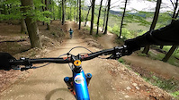
Popular Schmallenberg Mountain Biking Trails
• 35 ★ 4.5 • 1,421 ft • 0 ft • 726 •
Less popular black difficulty singletrack. This mountain bike primary trail can be used downhill only and has a moderate overall physical rating. It features berm, bridge, drop, jump and gap jump. Trail visibility is always easy to follow. On average it takes 1 minutes to complete this trail.
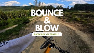
• 90 ★ 4.9 • 3,068 ft • 0 ft • 722 •
The name is program. With almost more time in the air than on the ground. The Bounce & Blow sends you over smooth lips up into the couds. With a wide trail profile and safety build tables, the jump-line is your first step towards...
• 50 ★ 4.7 • 2,867 ft • 0 ft • 714 •
Dresses in classic lumberjack plaid. The brings the north shore of vancouver right here to the bike park. The countless steep berms and off-cambers underline this trail's raw nature. With that said, you should definitely take a lap with...
• 75 ★ 4.0 • 2,211 ft • 3 ft • 708 •
Like a finely curated , this hybrid-trail hits you straight with a set of bangers. Various mixed features such as brems, jumps , and rockgardens are caved into natural soil and keep you working the whole way through. The is the choise...
• 40 ★ 5.0 • 3,392 ft • 0 ft • 679 •
The Save Wimmons is the perfect choice for riders who seek a fun lap in the bike park. Natural, but still playful. The Save Wimmons offers exciting Build-In features along its way doen the mountain.
Photos of Schmallenberg Mountain Bike
Videos of Schmallenberg Mountain Bike
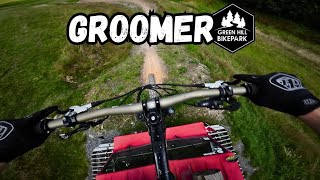
trail: Groomer
0:25 |
47 |
Aug 28, 2023

trail: Bounce & Blow
0:09 |
252 |
May 22, 2023
trail: Bounce & Blow
0:09 |
|
May 22, 2023
trail: Bounce & Blow
0:08 |
111 |
May 21, 2023
youtuber
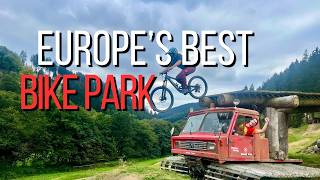
![Bounce & Blow Greenhill Bikepark Level Rot...]()
trail: Bounce & Blow
0:31 |
133 |
Jan 7, 2025 , Schmallenberg
youtuber
![Bike Republic Solden - 'The Whistler of Europe'?]()
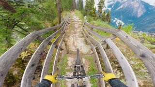
trail: Bike Republic Sölden Line
21:36 |
138 |
Sep 29, 2024 , Schmallenberg
Recent Trail Reports
| status | trail | date | condition | info | user |
|---|---|---|---|---|---|
| Thin Air | Oct 4, 2025 @ 2:37pm (Europe/Luxembourg) Oct 4, 2025 | Wet | montogeek | ||
| Save Wimmons | Oct 4, 2025 @ 2:37pm (Europe/Luxembourg) Oct 4, 2025 | Wet | montogeek | ||
| Moose Cruise | Oct 4, 2025 @ 2:37pm (Europe/Luxembourg) Oct 4, 2025 | Wet | montogeek | ||
| Beer Connector | Oct 4, 2025 @ 2:37pm (Europe/Luxembourg) Oct 4, 2025 | Wet | montogeek | ||
| Canadian Tuxedo | Oct 4, 2025 @ 2:37pm (Europe/Luxembourg) Oct 4, 2025 | Wet | montogeek | ||
| I Love Fidlock | Oct 4, 2025 @ 2:37pm (Europe/Luxembourg) Oct 4, 2025 | Wet | montogeek | ||
| Hohe Lied | Oct 4, 2025 @ 2:37pm (Europe/Luxembourg) Oct 4, 2025 | Variable | montogeek | ||
| Bounce & Blow | Oct 4, 2025 @ 2:37pm (Europe/Luxembourg) Oct 4, 2025 | Wet | montogeek | ||
| Bike Republic Sölden Line Lower | Oct 4, 2025 @ 2:37pm (Europe/Luxembourg) Oct 4, 2025 | Wet | montogeek | ||
| Bike Republic Sölden Line | Oct 4, 2025 @ 2:37pm (Europe/Luxembourg) Oct 4, 2025 | Wet | montogeek |
Activity Feed
| username | action | type | title | date |
|---|---|---|---|---|
| lvburik | vote | trail | activity #97555246 and 8 more | Jun 22, 2026 @ 5:35am 13 hours |
| Nicoleg8nmRK | wishlist | region | activity #97381468 | Jun 20, 2026 @ 4:37am 3 days |
| Grzesiek38 | add | photo | activity #96848773 and 1 more | Jun 12, 2026 @ 10:10pm Jun 12, 2026 |
| Synert | vote | trail | activity #95061525 | May 19, 2026 @ 1:02pm May 19, 2026 |
| Synert | ridden | trail | activity #95061512 and 1 more | May 19, 2026 @ 1:01pm May 19, 2026 |
Recent Comments
| username | type | title | comment | date |
|---|---|---|---|---|
| trail | Super nice! My fav! Even as a beginner you can... | Aug 30, 2024 @ 11:43am Aug 30, 2024 | ||
| trail | Super tight turns, not quite my style but... | Aug 30, 2024 @ 11:41am Aug 30, 2024 | ||
| trail | Very nice for people who likes ruff tarain It... | Aug 30, 2024 @ 11:35am Aug 30, 2024 | ||
| trail | Schöner, technischer Trail, aber nicht... | Nov 13, 2022 @ 1:33pm Nov 13, 2022 |
Local Badges
-

Epic Mountain Bike Climb 2k518 awarded -

Climbing 10k Badge41 awarded -

Mountain Biking 100k Badge0 awarded -

Epic Ride Descent 2k518 awarded -

Descent 10k Badge51 awarded -

Descent 100k Badge0 awarded
Bike & Skill Parks
| name | type | city | rating |
|---|---|---|---|
| Green Hill Bikepark | bike park | Schmallenberg |
Activity Type Stats
| activitytype | trails | distance | descent | descent distance | total vertical | rating | global rank | state rank | photos | reports | routes | ridelogs |
|---|---|---|---|---|---|---|---|---|---|---|---|---|
| Mountain Bike | 21 | 8 miles | 4,236 ft | 7 miles | 614 ft | #1,399 | #11 | 17 | 243 | 2,525 | ||
| E-Bike | 21 | 8 miles | 4,236 ft | 7 miles | 614 ft | #648 | #14 | 243 | 190 |
Frequently Asked Questions About Schmallenberg
▼
What are the best places to ride in Schmallenberg?
Schmallenberg has 1 areas to explore for mountain biking. The top rated areas are:
▼
What are the highest rated mountain biking trails in Schmallenberg?
The highest rated mountain biking trails in Schmallenberg are:
- Bounce & Blow (4.5/5)
- I Love Fidlock (4.4/5)
- Pablo (4.4/5)
- Canadian Tuxedo (4.3/5)
- Groomer (4.3/5)
▼
What is the best time of the year to ride in Schmallenberg?
Based on ride log data, the most popular months to ride in Schmallenberg are:
- August (13 activities)
- September (11 activities)
- October (6 activities)
▼
Where can I park to ride in Schmallenberg?
Check the Schmallenberg trail map for trailhead and parking information. Community members regularly update access and parking details for trails in the area.
Trails
Points of Interest
- By MarcBogadi
 & contributors
 - Admins: apply
- #52059 - 2,021 views
- schmallenberg activity log | embed map of Schmallenberg mountain bike trails | schmallenberg mountain biking points of interest
Downloading of trail gps tracks in kml & gpx formats is enabled for Schmallenberg.
You must login to download files.