close
-
Layers w
- Weather Layers
- Pro
- Pro
- Pro
- Pro
- Pro
- Pro
- More Layers
- Pro
- Pro
- Pro
- Pro
-
Upgrade to

3D
Trail Conditions
- Unknown
- Snow Groomed
- Snow Packed
- Snow Covered
- Snow Cover Partial
- Freeze/thaw Cycle
- Icy
- Prevalent Mud
- Wet
- Variable
- Ideal
- Dry
- Very Dry
Trail Flow (Ridden Direction)
Trailforks scans users ridelogs to determine the most popular direction each trail is ridden. A good flowing trail network will have most trails flowing in a single direction according to their intension.
The colour categories are based on what percentage of riders are riding a trail in its intended direction.
The colour categories are based on what percentage of riders are riding a trail in its intended direction.
- > 96%
- > 90%
- > 80%
- > 70%
- > 50%
- < 50%
- bi-directional trail
- no data
Trail Last Ridden
Trailforks scans ridelogs to determine the last time a trail was ridden.
- < 2 days
- < 1 week
- < 2 weeks
- < 1 month
- < 6 months
- > 6 months
Trail Ridden Direction
The intended direction a trail should be ridden.
- Downhill Only
- Downhill Primary
- Both Directions
- Uphill Primary
- Uphill Only
- One Direction
Contribute Details
Colors indicate trail is missing specified detail.
- Description
- Photos
- Description & Photos
- Videos
Trail Popularity ?
Trailforks scans ridelogs to determine which trails are ridden the most in the last 9 months.
Trails are compared with nearby trails in the same city region with a possible 25 colour shades.
Think of this as a heatmap, more rides = more kinetic energy = warmer colors.
- most popular
- popular
- less popular
- not popular
ATV/ORV/OHV Filter
Max Vehicle Width
inches
US Cell Coverage
Legend

Radar Time
Activity Recordings
Trailforks uses anonymized public activity data.
?
Activity Recordings
Trailforks uses anonymized public activity data.
?
Personal Heatmap
▶
Activity Types
all
/
none
▶
Options
2
Date range
month
–
Winter Trails
Warning
A routing network for winter maps does not exist. Selecting trails using the winter trails layer has been disabled.
Missing Trails
Most Popular
Least Popular
Trails are colored based on popularity. The more popular a trail is, the more red. Less popular trails trend towards green.
Jump Magnitude Heatmap
Heatmap of where riders jump on trails. Zoom in to see individual jumps, click circles to view jump details.
BC Backroad Status
![map legend]()
Service Road Atlas is a free to use, community-driven service for viewing and creating reports on the numerous back-country service roads around B.C. and Alberta.

Slope Aspect
Direction the slope faces
Trails Deemphasized
Trails are shown in grey.
Only show trails with no bike usage.
Suggested Layers
Based on selected activity type
Save the current map location and zoom level as your default home location whenever this page is loaded.
Save
No description for Scuol has been added yet!
Login or register to submit one.
Links
This region uses the Uk/Euro style trail grading system.
Region Supporters & Maintainers
trail builderSponsor
Activities Click to view
- Mountain Bike
149 trails
- E-Bike
149 trails
- Adaptive Bike
6 trails
- Hike
159 trails
- Trail Running
159 trails
- Snowshoe
0 trails
- Downhill Ski
0 trails
- Backcountry Ski
0 trails
- Nordic Ski
0 trails
Region Details
- 38
- 30
- 51
- 22
- 8
Region Status
Open as of 2 daysLocal Trail Association
Stats
- Avg Trail Rating
- Trails (view details)
- 165
- Trails Mountain Bike
- 149
- Trails E-Bike
- 149
- Trails Gravel Bike
- 1
- Trails Adaptive Bike
- 6
- Trails Hike
- 159
- Trails Trail Running
- 159
- Total Distance
- 170 miles
- Total Descent Distance
- 89 miles
- Total Descent
- 56,846 ft
- Total Vertical
- 6,110 ft
- Highest Trailhead
- 9,744 ft
- Reports
- 2,403
- Photos
- 318
- Ridden Counter
- 10,881
Sub Regions
-
Scuol - Pure Alpine Trails
- 30
- 50
- 20
- 8
Popular Scuol Mountain Biking Trails
• 100 ★ 3.9 • 2 miles • 18 ft • 320 •
Popular blue difficulty singletrack. This multi-use trail can be used downhill primary. It features bridge and jump. Trail visibility is always easy to follow. On average it takes 4 minutes to complete this trail.
• 95 ★ 3.8 • 3,573 ft • 0 ft • 246 •
Popular blue difficulty family friendly alpine singletrack. This mountain bike primary trail can be used downhill primary and has a easy overall physical rating. Trail visibility is always easy to follow. On average it takes 2 minutes to complete this trail.
• 75 ★ 3.4 • 2 miles • 133 ft • 217 •
Popular blue difficulty alpine singletrack. This multi-use trail can be used downhill primary. On average it takes minutes to complete this trail.
• 95 ★ 4.1 • 1 mile • 49 ft • 201 •
Highly rated popular red difficulty alpine singletrack. This multi-use trail can be used downhill primary and has a moderate overall physical rating. It features bridge. Trail visibility is always easy to follow. On average it takes 34 minutes to complete this trail.
• 95 ★ 3.2 • 3,491 ft • 194 ft • 199 •
In a just right angle the trail climbs perfectly towards Alp .
• 80 ★ 3.2 • 2 miles • 1,134 ft • 176 •
From Heidelberger Hütte up the you`ve got to options: Either strong legs or push you bike. Nevertheless the downhill down to is worth the effort.
Scuol Mountain Bike Routes
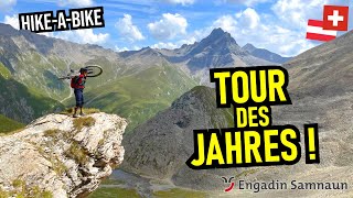
Trail Tales #16 Fimberpass Featured
28 miles • 3,948 ft • 15 • Point to Point •
. . Bike alongside the inn to continue on back to Scuol.
Sentiago Loop Featured
★ 3.0 • 13 miles • 1,006 ft • 7 • Loop •
Rasante Abfahrt ab nach Sent, Sur En und Scuol. Für sportliche Singletrail-Fahrer, welche sich auf...
★ 5.0 • 15 miles • 2,122 ft • 13 • Loop •
As soon as you arrive at the mountain, you face the first ascent on the to the reservoir in the direction...
★ 4.7 • 21 miles • 2,878 ft • 14 • Point to Point •
Trailforks edition of this route, the official route of the toursim Bureau is different. This on is...
149 miles • 26,064 ft • 34 •
Postautotour Ride https://www.postautotour.bike/de
Photos of Scuol Mountain Bike
Videos of Scuol Mountain Bike

trail: Pachific
0:40 |
62 |
Jun 5, 2022
youtuber
![ENGADIN SAMNAUN Episch: über Val Gronda &...]()
trail: Fimberpass
27:15 |
75 |
Jan 9, 2026 , Scuol
youtuber
![ORTLER Episode 1: Val Uina von Nauders via...]()
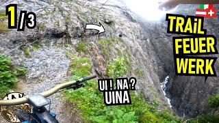
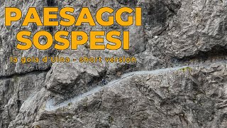
trail: Uinaschlucht
17:45 |
121 |
Oct 18, 2024 , Scuol

trail: Uphill Piz Clünas
0:37 |
275 |
Aug 7, 2022 , Scuol
trail: Uinaschlucht
2:21 |
54 |
Apr 22, 2025 , Scuol
Current Trail Warnings
| status | trail | date | condition | user | info |
|---|---|---|---|---|---|
| Uinaschlucht | Jun 24, 2026 @ 4:47pm (Europe/Zurich) 2 days | Dry | Helma19 | E-Bike Amtlich geschlossen bis 10. Juli 26.... |
Recent Trail Reports
| status | trail | date | condition | info | user |
|---|---|---|---|---|---|
| Baraigla | May 31, 2026 @ 2:47pm (Europe/Zurich) May 31, 2026 | Dry | Everyday-is-Gaperday | ||
| Sulvadi | May 31, 2026 @ 2:45pm (Europe/Zurich) May 31, 2026 | Ideal | Everyday-is-Gaperday | ||
| Pachific | May 31, 2026 @ 2:44pm (Europe/Zurich) May 31, 2026 | Dry | Everyday-is-Gaperday | ||
| Pachific Uphill | May 31, 2026 @ 2:44pm (Europe/Zurich) May 31, 2026 | Dry | Everyday-is-Gaperday | ||
| Lais da Pesch | May 31, 2026 @ 2:43pm (Europe/Zurich) May 31, 2026 | Dry | Everyday-is-Gaperday | ||
| Clarai | May 31, 2026 @ 2:43pm (Europe/Zurich) May 31, 2026 | Dry | Everyday-is-Gaperday | ||
| Along the Gravel | May 31, 2026 @ 2:42pm (Europe/Zurich) May 31, 2026 | Ideal | Everyday-is-Gaperday | ||
| Nischöl | May 31, 2026 @ 2:42pm (Europe/Zurich) May 31, 2026 | Dry | Everyday-is-Gaperday | ||
| Scuol - Sent | Oct 18, 2025 @ 12:40pm (Europe/Vaduz) Oct 18, 2025 | Ideal | daflow17 | ||
| Val Sinestra Access Road | Oct 18, 2025 @ 12:40pm (Europe/Vaduz) Oct 18, 2025 | Ideal | daflow17 |
National Scenic Trails & Official Routes
-
Trans-Altarezia Bike #32
- Mountain Bike
- E-Bike

Activity Feed
| username | action | type | title | date |
|---|---|---|---|---|
| Helma19 | wishlist | trail | activity #97823302 | Jun 26, 2026 @ 3:17am 11 hours |
| Helma19 | add | report | activity #97697202 | Jun 24, 2026 @ 7:47am 2 days |
| Niccci | wishlist | trail | activity #97470818 | Jun 21, 2026 @ 4:17am Jun 21, 2026 |
| Everyday-is-Gaperday | wishlist | trail | activity #97463094 | Jun 21, 2026 @ 2:02am Jun 21, 2026 |
| MarcelA3uYbH | ridden | trail | activity #97240323 and 3 more | Jun 18, 2026 @ 3:08am Jun 18, 2026 |
Recent Comments
| username | type | title | comment | date |
|---|---|---|---|---|
| trail | Not a big deal for expert riders and I don't... | Jun 2, 2026 @ 4:48am Jun 2, 2026 | ||
| trail | Trail defenitly CLOSES, there is now trail... | Apr 14, 2026 @ 4:18am Apr 14, 2026 | ||
| trail | Great and very easy natural trail with... | Sep 2, 2025 @ 11:23pm Sep 2, 2025 | ||
| trail | Easy Trail and not steep. | Jul 28, 2025 @ 8:37am Jul 28, 2025 | ||
| trail | rocky, rooty and realy narrow, plus... | Jul 28, 2025 @ 8:26am Jul 28, 2025 |
Local Badges
-

Epic Ride Climb 2k250 awarded -

Climbing 10k Badge20 awarded -

Climbing 100k Badge1 awarded -

Epic Ride Descent 2k250 awarded -

Descent 10k Badge27 awarded -

Descent 100k Badge1 awarded
Bike & Skill Parks
| name | type | city | rating |
|---|---|---|---|
| PALÜDS Center da Trail | skill park | Scuol | |
| Gurlaina | skill park | Scuol |
Local Trail Supporters
- Trailuniun
![]()
Activity Type Stats
| activitytype | trails | distance | descent | descent distance | total vertical | rating | global rank | state rank | photos | reports | routes | ridelogs |
|---|---|---|---|---|---|---|---|---|---|---|---|---|
| Mountain Bike | 149 | 151 miles | 45,246 ft | 77 miles | 5,446 ft | #912 | #7 | 315 | 2,403 | 5 | 2,104 | |
| E-Bike | 149 | 151 miles | 45,246 ft | 77 miles | 5,446 ft | #470 | #46 | 2 | 2,331 | 13 | 397 | |
| Gravel Bike | 1 | 2 miles | 909 ft | #2,579 | #64 | 3 | 23 | |||||
| Adaptive Bike | 6 | 10 miles | 1,201 ft | 2 miles | 3,320 ft | #89 | #82 | 170 | ||||
| Hike | 159 | 169 miles | 56,312 ft | 88 miles | 6,109 ft | #632 | #14 | 2,389 | 1 | 454 | ||
| Trail Running | 159 | 169 miles | 56,312 ft | 88 miles | 6,109 ft | #518 | #13 | 2,389 | 1 | 191 |
Frequently Asked Questions About Scuol
▼
What are the best places to ride in Scuol?
Scuol has 1 areas to explore for mountain biking. The top rated areas are:
▼
What are the highest rated mountain biking trails in Scuol?
The highest rated mountain biking trails in Scuol are:
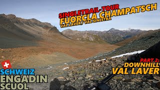
- Val Laver (4.4/5)
- Fimberpass (4.3/5)
- Putschigls (4.3/5)
- Val Gronda (4.3/5)
- Val Sinestra II (4.2/5)
▼
What is the best time of the year to ride in Scuol?
Based on ride log data, the most popular months to ride in Scuol are:
- August (37 activities)
- July (30 activities)
- September (15 activities)
▼
Where can I park to ride in Scuol?
There are 3 parking locations listed in Scuol. The most popular parking spots are: View all parking and trailhead locations on the map to plan your visit.
Activities
Trails
- By alexmarengo
 & contributors
 - Admins: Trailuniun, trailworks
- #20841 - 13,027 views
- scuol activity log | embed map of Scuol mountain bike trails | scuol mountain biking points of interest polygons
Downloading of trail gps tracks in kml & gpx formats is enabled for Scuol.
You must login to download files.