close
-
Layers w
- Weather Layers
- Pro
- Pro
- Pro
- Pro
- Pro
- Pro
- More Layers
- Pro
- Pro
- Pro
- Pro
-
Upgrade to

3D
Trail Conditions
- Unknown
- Snow Groomed
- Snow Packed
- Snow Covered
- Snow Cover Partial
- Freeze/thaw Cycle
- Icy
- Prevalent Mud
- Wet
- Variable
- Ideal
- Dry
- Very Dry
Trail Flow (Ridden Direction)
Trailforks scans users ridelogs to determine the most popular direction each trail is ridden. A good flowing trail network will have most trails flowing in a single direction according to their intension.
The colour categories are based on what percentage of riders are riding a trail in its intended direction.
The colour categories are based on what percentage of riders are riding a trail in its intended direction.
- > 96%
- > 90%
- > 80%
- > 70%
- > 50%
- < 50%
- bi-directional trail
- no data
Trail Last Ridden
Trailforks scans ridelogs to determine the last time a trail was ridden.
- < 2 days
- < 1 week
- < 2 weeks
- < 1 month
- < 6 months
- > 6 months
Trail Ridden Direction
The intended direction a trail should be ridden.
- Downhill Only
- Downhill Primary
- Both Directions
- Uphill Primary
- Uphill Only
- One Direction
Contribute Details
Colors indicate trail is missing specified detail.
- Description
- Photos
- Description & Photos
- Videos
Trail Popularity ?
Trailforks scans ridelogs to determine which trails are ridden the most in the last 9 months.
Trails are compared with nearby trails in the same city region with a possible 25 colour shades.
Think of this as a heatmap, more rides = more kinetic energy = warmer colors.
- most popular
- popular
- less popular
- not popular
ATV/ORV/OHV Filter
Max Vehicle Width
inches
US Cell Coverage
Legend

Radar Time
Activity Recordings
Trailforks uses anonymized public activity data.
?
Activity Recordings
Trailforks uses anonymized public activity data.
?
Personal Heatmap
▶
Activity Types
all
/
none
▶
Options
2
Date range
month
–
Winter Trails
Warning
A routing network for winter maps does not exist. Selecting trails using the winter trails layer has been disabled.
Missing Trails
Most Popular
Least Popular
Trails are colored based on popularity. The more popular a trail is, the more red. Less popular trails trend towards green.
Jump Magnitude Heatmap
Heatmap of where riders jump on trails. Zoom in to see individual jumps, click circles to view jump details.
BC Backroad Status
![map legend]()
Service Road Atlas is a free to use, community-driven service for viewing and creating reports on the numerous back-country service roads around B.C. and Alberta.

Slope Aspect
Direction the slope faces
Trails Deemphasized
Trails are shown in grey.
Only show trails with no bike usage.
Suggested Layers
Based on selected activity type
Save the current map location and zoom level as your default home location whenever this page is loaded.
Save
No description for Seravezza has been added yet!
Login or register to submit one.
This region uses the Uk/Euro style trail grading system.
Activities Click to view
- Mountain Bike
40 trails
- E-Bike
32 trails
- Adaptive Bike
0 trails
- Horse
10 trails
- Hike
27 trails
- Trail Running
25 trails
Region Details
- 6
- 6
- 14
- 6
- 4
Region Status
Caution as of Sep 8, 2025Stats
- Avg Trail Rating
- Trails (view details)
- 37
- Trails Mountain Bike
- 40
- Trails E-Bike
- 32
- Trails Horse
- 10
- Trails Hike
- 27
- Trails Trail Running
- 25
- Total Distance
- 16 miles
- Total Descent Distance
- 11 miles
- Total Descent
- 10,086 ft
- Total Vertical
- 4,500 ft
- Highest Trailhead
- 4,677 ft
- Reports
- 119
- Photos
- 67
- Ridden Counter
- 1,121
Sub Regions
-
Alpi Apuane
- 4
- 5
- 2
- 3
-
Monte Folgorito
- 1
- 7
- 4
- 1
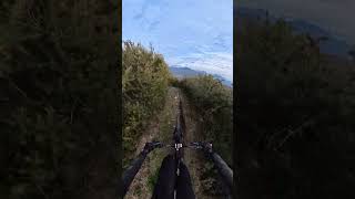
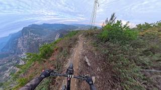
Popular Seravezza Mountain Biking Trails
• 100 ★ 4.0 • 2 miles • 359 ft • 57 •
Popular green difficulty mixed. This multi-use trail can be used both directions. On average it takes 17 minutes to complete this trail.
• 85 ★ 0.0 • 2,772 ft • 30 ft • 55 •
Popular red difficulty singletrack. This multi-use trail can be used downhill only. On average it takes 14 minutes to complete this trail.
• 95 ★ 0.0 • 1,257 ft • 0 ft • 53 •
Popular blue difficulty singletrack. This mountain bike primary trail can be used downhill only. On average it takes 2 minutes to complete this trail.
• 50 ★ 4.7 • 2 miles • 3 ft • 46 •
Moderately popular red difficulty singletrack. This mountain bike primary trail and has a easy overall physical rating. It features jump and rock garden. On average it takes 26 minutes to complete this trail.
• 75 ★ 0.0 • 2,372 ft • 46 ft • 41 •
Popular blue difficulty singletrack. This mountain bike primary trail can be used downhill primary. On average it takes 4 minutes to complete this trail.
• 95 ★ 0.0 • 1,745 ft • 10 ft • 39 •
Popular blue difficulty singletrack. This mountain bike primary trail can be used downhill primary. On average it takes 4 minutes to complete this trail.
• 65 ★ 0.0 • 2 miles • 31 ft • 38 •
Moderately popular blue difficulty singletrack. This multi-use trail can be used downhill primary and has a hard overall physical rating with a 31 ft blue climb. Trail visibility is always easy to follow. On average it takes 16 minutes to complete this trail.
Photos of Seravezza Mountain Bike
Videos of Seravezza Mountain Bike
youtuber
![Croce del Folgorito - Monte Folgorito]()
trail: Croce Del Folgorito
0:23 |
73 |
Mar 4, 2026 , Seravezza
youtuber
![Folgorito - Monte di Ripa - Serravezza]()
trail: Croce Del Folgorito
15:14 |
68 |
Mar 2, 2026 , Seravezza

trail: Isola Santa
6:57 |
309 |
Dec 1, 2021 , Seravezza

trail: Retrocorchia
6:57 |
154 |
Dec 1, 2021 , Seravezza
Recent Trail Reports
| status | trail | date | condition | info | user |
|---|---|---|---|---|---|
| Foce Dei Fordazzani | Sep 8, 2025 @ 6:06am Sep 8, 2025 | Ideal | Pennellone | ||
| Freddone | Sep 8, 2025 @ 6:05am Sep 8, 2025 | Ideal | Pennellone | ||
| Isola Santa | Sep 8, 2025 @ 6:04am Sep 8, 2025 | Ideal | Pennellone | ||
| Omo Selvatico - CAI 128 | Sep 8, 2025 @ 6:03am Sep 8, 2025 | Ideal | Pennellone | ||
| Retrocorchia | Sep 8, 2025 @ 5:57am Sep 8, 2025 | Ideal | Pennellone | ||
| Variante enduro 3 | Aug 23, 2025 @ 9:12am Aug 23, 2025 | Ideal | fede4 | ||
| Flowrito | Aug 23, 2025 @ 9:12am Aug 23, 2025 | Ideal | fede4 | ||
| Monte Folgorito | Aug 23, 2025 @ 9:12am Aug 23, 2025 | Ideal | fede4 | ||
| Variante Enduro 1 | Aug 18, 2025 @ 5:59am Aug 18, 2025 | Ideal | lucaf7DIuP | ||
| Nikola | Aug 16, 2025 @ 11:05am Aug 16, 2025 | Ideal | mchesi |
Activity Feed
| username | action | type | title | date |
|---|---|---|---|---|
| ClaudioConforti | vote | trail | activity #91147259 | Mar 23, 2026 @ 8:58am Mar 23, 2026 |
| trailforks | add | video | activity #89963708 | Mar 4, 2026 @ 11:00am Mar 4, 2026 |
| trailforks | add | video | activity #89840336 | Mar 2, 2026 @ 8:00am Mar 2, 2026 |
| morenomgm | wishlist | trail | activity #89642540 | Feb 27, 2026 @ 12:08pm Feb 27, 2026 |
| Albe79 | comment | trail | activity #86095089 | Dec 26, 2025 @ 10:15am Dec 26, 2025 |
Recent Comments
| username | type | title | comment | date |
|---|---|---|---|---|
| trail | A chi piace il croccante alla destra della... | Dec 26, 2025 @ 10:15am Dec 26, 2025 | ||
| trail | In salita da Ponte Merletti, un po' ripida la... | Apr 15, 2025 @ 3:56am Apr 15, 2025 | ||
| trail | Prima parte dopo la croce difficile, lenta e... | Mar 30, 2025 @ 10:02am Mar 30, 2025 | ||
| trail | Per chi non ci fosse mai stato le varianti... | Mar 29, 2025 @ 5:25pm Mar 29, 2025 | ||
| trail | Direi spettacolare!!!! Per gli amanti del rock... | Mar 29, 2025 @ 5:16pm Mar 29, 2025 |
Local Badges
-

Epic Mountain Bike Climb 2k74 awarded -

Climbing 10k Badge10 awarded -

Mountain Biking 100k Badge0 awarded -

Epic Ride Descent 2k74 awarded -

Descent 10k Badge10 awarded -

Descent 100k Badge0 awarded
Activity Type Stats
| activitytype | trails | distance | descent | descent distance | total vertical | rating | global rank | state rank | photos | reports | routes | ridelogs |
|---|---|---|---|---|---|---|---|---|---|---|---|---|
| Mountain Bike | 40 | 16 miles | 10,085 ft | 11 miles | 4,501 ft | #4,929 | #352 | 67 | 119 | 1,090 | ||
| E-Bike | 32 | 14 miles | 7,762 ft | 9 miles | 4,357 ft | #4,811 | #461 | 100 | 229 | |||
| Horse | 10 | #3,108 | #218 | 1 | ||||||||
| Hike | 27 | 7 miles | 4,380 ft | 5 miles | 4,501 ft | #8,122 | #485 | 94 | 250 | |||
| Trail Running | 25 | 6 miles | 2,972 ft | 3 miles | 4,501 ft | #8,799 | #592 | 90 | 16 |
Frequently Asked Questions About Seravezza
▼
What are the best places to ride in Seravezza?
Seravezza has 2 areas to explore for mountain biking. The top rated areas are:
▼
What are the highest rated mountain biking trails in Seravezza?
The highest rated mountain biking trails in Seravezza are:
- Puntato (4.1/5)
- Foce Di Mosceta - Passo dell'Alpino (4.1/5)
- Isola Santa (4.1/5)
- Folgorito - Monte di Ripa (4.1/5)
- Monte Folgorito - Pasquilio (4/5)
▼
What is the best time of the year to ride in Seravezza?
Based on ride log data, the most popular months to ride in Seravezza are:
- June (2 activities)
- May (2 activities)
- April (2 activities)
▼
Where can I park to ride in Seravezza?
There are 1 parking locations listed in Seravezza. The most popular parking spots are:
Activities
Trails
- By singlespeedissimo
 WCT & contributors
 - Admins: DanielePracchia, DanielePracchia
- #45836 - 996 views
- seravezza activity log | embed map of Seravezza mountain bike trails | seravezza mountain biking points of interest
Downloading of trail gps tracks in kml & gpx formats is enabled for Seravezza.
You must login to download files.