close
-
Layers w
- Weather Layers
- Pro
- Pro
- Pro
- Pro
- Pro
- Pro
- More Layers
- Pro
- Pro
- Pro
- Pro
-
Upgrade to

3D
Trail Conditions
- Unknown
- Snow Groomed
- Snow Packed
- Snow Covered
- Snow Cover Partial
- Freeze/thaw Cycle
- Icy
- Prevalent Mud
- Wet
- Variable
- Ideal
- Dry
- Very Dry
Trail Flow (Ridden Direction)
Trailforks scans users ridelogs to determine the most popular direction each trail is ridden. A good flowing trail network will have most trails flowing in a single direction according to their intension.
The colour categories are based on what percentage of riders are riding a trail in its intended direction.
The colour categories are based on what percentage of riders are riding a trail in its intended direction.
- > 96%
- > 90%
- > 80%
- > 70%
- > 50%
- < 50%
- bi-directional trail
- no data
Trail Last Ridden
Trailforks scans ridelogs to determine the last time a trail was ridden.
- < 2 days
- < 1 week
- < 2 weeks
- < 1 month
- < 6 months
- > 6 months
Trail Ridden Direction
The intended direction a trail should be ridden.
- Downhill Only
- Downhill Primary
- Both Directions
- Uphill Primary
- Uphill Only
- One Direction
Contribute Details
Colors indicate trail is missing specified detail.
- Description
- Photos
- Description & Photos
- Videos
Trail Popularity ?
Trailforks scans ridelogs to determine which trails are ridden the most in the last 9 months.
Trails are compared with nearby trails in the same city region with a possible 25 colour shades.
Think of this as a heatmap, more rides = more kinetic energy = warmer colors.
- most popular
- popular
- less popular
- not popular
ATV/ORV/OHV Filter
Max Vehicle Width
inches
US Cell Coverage
Legend

Radar Time
Activity Recordings
Trailforks uses anonymized public activity data.
?
Activity Recordings
Trailforks uses anonymized public activity data.
?
Personal Heatmap
▶
Activity Types
all
/
none
▶
Options
2
Date range
month
–
Winter Trails
Warning
A routing network for winter maps does not exist. Selecting trails using the winter trails layer has been disabled.
Missing Trails
Most Popular
Least Popular
Trails are colored based on popularity. The more popular a trail is, the more red. Less popular trails trend towards green.
Jump Magnitude Heatmap
Heatmap of where riders jump on trails. Zoom in to see individual jumps, click circles to view jump details.
BC Backroad Status
![map legend]()
Service Road Atlas is a free to use, community-driven service for viewing and creating reports on the numerous back-country service roads around B.C. and Alberta.

Slope Aspect
Direction the slope faces
Trails Deemphasized
Trails are shown in grey.
Only show trails with no bike usage.
Suggested Layers
Based on selected activity type
Save the current map location and zoom level as your default home location whenever this page is loaded.
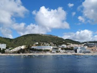
SaveSesimbra trails is a riding area where you can find the best EN/AM trails near the coast line.
source: Sesimbra Trails
Links
This region uses the Uk/Euro style trail grading system.
Activities Click to view
- Mountain Bike
33 trails
- E-Bike
20 trails
- Adaptive Bike
0 trails
- Winter Fat Bike
0 trails
- Hike
30 trails
- Trail Running
31 trails
Region Details
- 7
- 9
- 10
- 5
- 1
Region Status
Open as of May 23, 2026Stats
- Avg Trail Rating
- Trails (view details)
- 32
- Trails Mountain Bike
- 34
- Trails E-Bike
- 20
- Trails Hike
- 30
- Trails Trail Running
- 31
- Total Distance
- 12 miles
- Total Descent
- 5,512 ft
- Total Vertical
- 901 ft
- Highest Trailhead
- 1,030 ft
- Reports
- 268
- Photos
- 27
- Ridden Counter
- 957
Popular Sesimbra Mountain Biking Trails
• 90 ★ 3.4 • 4,236 ft • 4 ft • 66 •
Trilho que começa no Castelo e acaba em frente ao 4 Seasons em Sesimbra. Single track na encosta do Castelo com uma vista fantástica e alguns obstáculos como drops, raizes e alguns saltos. Não aconselhado a principiantes.
• 65 ★ 4.5 • 3,396 ft • 139 ft • 60 •
Moderately popular green difficulty singletrack. This mountain bike primary trail can be used downhill primary. It features drop, jump and skinny. On average it takes 2 minutes to complete this trail.
• 90 ★ 0.0 • 1,237 ft • 50 ft • 59 •
Popular green difficulty singletrack. This mountain bike primary trail can be used downhill primary with a 50 ft green climb. It features drop. On average it takes 3 minutes to complete this trail.
• 85 ★ 4.0 • 1 mile • 71 ft • 59 •
Popular green difficulty doubletrack. This mountain bike primary trail can be used downhill primary and has a easy overall physical rating with a 71 ft blue climb. It features rock face, rock garden and other. On average it takes 12 minutes to complete this trail.
• 60 ★ 0.0 • 4,295 ft • 18 ft • 58 •
Moderately popular green difficulty singletrack. This multi-use trail can be used both directions. It features rock face and rock garden. On average it takes 3 minutes to complete this trail.
• 55 ★ 3.0 • 2,467 ft • 6 ft • 56 •
Moderately popular blue difficulty singletrack. This multi-use trail can be used downhill only. Trail visibility is always easy to follow. On average it takes 3 minutes to complete this trail.
• 80 ★ 3.0 • 1,387 ft • 30 ft • 54 •
Popular blue difficulty singletrack. This mountain bike primary trail can be used downhill primary. It features rock face and rock garden. On average it takes 2 minutes to complete this trail.
• 40 ★ 4.0 • 2,029 ft • 0 ft • 45 •
Moderately popular green difficulty singletrack. This mountain bike primary trail can be used downhill primary. On average it takes 2 minutes to complete this trail.
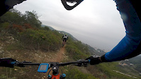
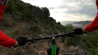
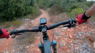
Photos of Sesimbra Mountain Bike
Videos of Sesimbra Mountain Bike
trail: AVET I
0:59 |
172 |
Dec 10, 2017
trail: Descida Pedreiras
4:35 |
146 |
Dec 9, 2022 , Sesimbra

trail: Abelhas
4:35 |
219 |
Dec 9, 2022 , Sesimbra

trail: AVET I
4:35 |
143 |
Dec 9, 2022 , Sesimbra

trail: Caverna
4:35 |
131 |
Dec 9, 2022 , Sesimbra
trail: DH Assenta
0:02 |
346 |
Aug 18, 2020 , Sesimbra
trail: Trilho do Castelo
503 |
Aug 16, 2020 , Sesimbra
Recent Trail Reports
| status | trail | date | condition | info | user |
|---|---|---|---|---|---|
| Trilho da Cruz | May 23, 2026 @ 5:35pm (Europe/Lisbon) May 23, 2026 | Ideal | nukept | ||
| Viking Downhill Track | May 17, 2026 @ 10:27am (Europe/Lisbon) May 17, 2026 | Ideal | RicardoColaco | ||
| Sesimbra | May 17, 2026 @ 10:27am (Europe/Lisbon) May 17, 2026 | Ideal | RicardoColaco | ||
| Acceso Rock Garden | May 17, 2026 @ 10:27am (Europe/Lisbon) May 17, 2026 | Ideal | RicardoColaco | ||
| Castelo 2 | May 17, 2026 @ 10:27am (Europe/Lisbon) May 17, 2026 | Ideal | RicardoColaco | ||
| DH Assenta | May 17, 2026 @ 10:27am (Europe/Lisbon) May 17, 2026 | Ideal | RicardoColaco | ||
| Carraças | May 3, 2026 @ 10:02am (Europe/Lisbon) May 3, 2026 | Very Dry | nukept | ||
| Perimetral | May 3, 2026 @ 10:02am (Europe/Lisbon) May 3, 2026 | Ideal | nukept | ||
| Descida Pedreiras | May 3, 2026 @ 10:02am (Europe/Lisbon) May 3, 2026 | Ideal | nukept | ||
| Pedreira Pt1 | May 3, 2026 @ 10:02am (Europe/Lisbon) May 3, 2026 | Ideal | nukept |
Activity Feed
| username | action | type | title | date |
|---|---|---|---|---|
| nukept | add | report | activity #95387838 | May 24, 2026 @ 2:33am May 24, 2026 |
| RicardoColaco | add | report | activity #94893474 and 4 more | May 17, 2026 @ 5:51am May 17, 2026 |
| nukept | add | report | activity #93980833 and 3 more | May 3, 2026 @ 1:54pm May 3, 2026 |
| RicardoColaco | add | report | activity #91082050 and 4 more | Mar 22, 2026 @ 9:19am Mar 22, 2026 |
| RicardoColaco | vote | trail | activity #89841119 and 1 more | Mar 2, 2026 @ 8:16am Mar 2, 2026 |
Recent Comments
| username | type | title | comment | date |
|---|---|---|---|---|
| trail | Cool Trail for beginners | Nov 19, 2021 @ 1:06am Nov 19, 2021 | ||
| trail | Amazing Trail for advanced Riders with small... | Nov 19, 2021 @ 1:06am Nov 19, 2021 | ||
| trail | Map tracing doesn't match where the trail... | Feb 12, 2021 @ 5:11pm Feb 12, 2021 |
Local Badges
-

Epic Ride Climb 2k32 awarded -

Climbing 10k Badge17 awarded -

Climbing 100k Badge2 awarded -

Epic Ride Descent 2k32 awarded -

Descent 10k Badge17 awarded -

Descent 100k Badge2 awarded
Activity Type Stats
| activitytype | trails | distance | descent | descent distance | total vertical | rating | global rank | state rank | photos | reports | routes | ridelogs |
|---|---|---|---|---|---|---|---|---|---|---|---|---|
| Mountain Bike | 33 | 12 miles | 5,512 ft | 8 miles | 902 ft | #2,931 | #20 | 27 | 275 | 2,810 | ||
| E-Bike | 20 | 5 miles | 2,280 ft | 3 miles | 902 ft | #579 | #6 | 262 | 197 | |||
| Hike | 30 | 9 miles | 3,901 ft | 7 miles | 863 ft | #3,856 | #21 | 270 | 259 | |||
| Trail Running | 31 | 10 miles | 4,295 ft | 7 miles | 863 ft | #3,306 | #20 | 271 | 43 |
Frequently Asked Questions About Sesimbra
▼
What are the highest rated mountain biking trails in Sesimbra?
The highest rated mountain biking trails in Sesimbra are:
- DH Assenta (4.2/5)
- AVET I (4.1/5)
- Triple S (4.1/5)
- Abelhas (4.1/5)
- Praia de Cramesines (4.1/5)
▼
What is the best time of the year to ride in Sesimbra?
Based on ride log data, the most popular months to ride in Sesimbra are:
- February (11 activities)
- July (6 activities)
- September (5 activities)
▼
Where can I park to ride in Sesimbra?
Check the Sesimbra trail map for trailhead and parking information. Community members regularly update access and parking details for trails in the area.
▼
What is the longest trail in Sesimbra?
The longest trail in Sesimbra is Canteiros at 1.5 miles. View all trails sorted by distance.
- By carlosparentee & contributors
- Admins: elyari, AMG, marcossantamaria, Sesimbra
- #4325 - 5,237 views
- sesimbra activity log | embed map of Sesimbra mountain bike trails |
Downloading of trail gps tracks in kml & gpx formats is enabled for Sesimbra.
You must login to download files.