close
-
Layers w
- Weather Layers
- Pro
- Pro
- Pro
- Pro
- Pro
- Pro
- More Layers
- Pro
- Pro
- Pro
- Pro
-
Upgrade to

3D
Trail Conditions
- Unknown
- Snow Groomed
- Snow Packed
- Snow Covered
- Snow Cover Partial
- Freeze/thaw Cycle
- Icy
- Prevalent Mud
- Wet
- Variable
- Ideal
- Dry
- Very Dry
Trail Flow (Ridden Direction)
Trailforks scans users ridelogs to determine the most popular direction each trail is ridden. A good flowing trail network will have most trails flowing in a single direction according to their intension.
The colour categories are based on what percentage of riders are riding a trail in its intended direction.
The colour categories are based on what percentage of riders are riding a trail in its intended direction.
- > 96%
- > 90%
- > 80%
- > 70%
- > 50%
- < 50%
- bi-directional trail
- no data
Trail Last Ridden
Trailforks scans ridelogs to determine the last time a trail was ridden.
- < 2 days
- < 1 week
- < 2 weeks
- < 1 month
- < 6 months
- > 6 months
Trail Ridden Direction
The intended direction a trail should be ridden.
- Downhill Only
- Downhill Primary
- Both Directions
- Uphill Primary
- Uphill Only
- One Direction
Contribute Details
Colors indicate trail is missing specified detail.
- Description
- Photos
- Description & Photos
- Videos
Trail Popularity ?
Trailforks scans ridelogs to determine which trails are ridden the most in the last 9 months.
Trails are compared with nearby trails in the same city region with a possible 25 colour shades.
Think of this as a heatmap, more rides = more kinetic energy = warmer colors.
- most popular
- popular
- less popular
- not popular
ATV/ORV/OHV Filter
Max Vehicle Width
inches
US Cell Coverage
Legend

Radar Time
Activity Recordings
Trailforks uses anonymized public activity data.
?
Activity Recordings
Trailforks uses anonymized public activity data.
?
Personal Heatmap
▶
Activity Types
all
/
none
▶
Options
2
Date range
month
–
Winter Trails
Warning
A routing network for winter maps does not exist. Selecting trails using the winter trails layer has been disabled.
Missing Trails
Most Popular
Least Popular
Trails are colored based on popularity. The more popular a trail is, the more red. Less popular trails trend towards green.
Jump Magnitude Heatmap
Heatmap of where riders jump on trails. Zoom in to see individual jumps, click circles to view jump details.
BC Backroad Status
![map legend]()
Service Road Atlas is a free to use, community-driven service for viewing and creating reports on the numerous back-country service roads around B.C. and Alberta.

Slope Aspect
Direction the slope faces
Trails Deemphasized
Trails are shown in grey.
Only show trails with no bike usage.
Suggested Layers
Based on selected activity type
Save the current map location and zoom level as your default home location whenever this page is loaded.
Save
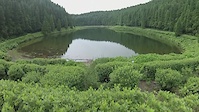
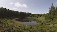
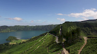
No description for Sete Cidades has been added yet!
Login or register to submit one.
Primary Trail Type: All-Mountain & Downhill
Shuttleable: YES
AKA: 7th Wonder
This region uses the Uk/Euro style trail grading system.
Activities Click to view
- Mountain Bike
22 trails
- E-Bike
18 trails
- Hike
21 trails
- Trail Running
21 trails
Region Details
- 6
- 4
- 10
- 1
- 1
Region Status
Caution as of Oct 25, 2025Stats
- Avg Trail Rating
- Trails (view details)
- 22
- Trails Mountain Bike
- 22
- Trails E-Bike
- 18
- Trails Hike
- 21
- Trails Trail Running
- 21
- Total Distance
- 5 miles
- Total Descent
- 2,990 ft
- Total Vertical
- 1,745 ft
- Highest Trailhead
- 2,667 ft
- Reports
- 29
- Photos
- 51
- Ridden Counter
- 506
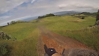
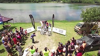
Popular Sete Cidades Mountain Biking Trails
• 5 ★ 5.0 • 4,426 ft • 0 ft • 26 •
is a trail located in São Miguel Azores Portugal, being a technical and muddy trail. Starting at the top of the mountains and ending on the Sete Cidades lagune, it has one of the most beautiful views of Sete Cidades. Made for Downhill...
• 95 ★ 5.0 • 2,592 ft • 0 ft • 22 •
Túnel trail is a super accessible track to any mountain biker. From rookie to advanced, guaranteed you will have fun on this one. Nothing to be scared, everything can be sent first try ;)
• 5 ★ 0.0 • 4,717 ft • 222 ft • 19 •
Less popular blue difficulty singletrack. This mountain bike primary trail can be used both directions and has a moderate overall physical rating with a 222 ft green climb. On average it takes 8 minutes to complete this trail.
• 100 ★ 0.0 • 2,500 ft • 2 ft • 12 •
Popular blue difficulty singletrack. This multi-use trail can be used downhill primary and has a moderate overall physical rating with a 2 ft blue climb. Trail visibility is always easy to follow.
• 100 ★ 0.0 • 1,089 ft • 0 ft • 12 •
Popular blue difficulty singletrack. This multi-use trail can be used downhill primary and has a moderate overall physical rating with a 0 ft blue climb. Trail visibility is always easy to follow.
• 95 ★ 5.0 • 2,320 ft • 0 ft • 11 •
Popular red difficulty singletrack. This multi-use trail can be used both directions and has a moderate overall physical rating with a 0 ft blue climb. Trail visibility is always easy to follow.
• 5 ★ 0.0 • 1 mile • 347 ft • 10 •
Less popular blue difficulty singletrack. This mountain bike primary trail can be used downhill primary and has a moderate overall physical rating. On average it takes 33 minutes to complete this trail.
Sete Cidades Mountain Bike Routes
13 miles • 2,359 ft • 0 • Loop •
Nice circular hike around the 2 lagoons, blue and green (Sete Cidades - , Azores), in São Miguel Island
Photos of Sete Cidades Mountain Bike
Videos of Sete Cidades Mountain Bike
trail: Mata do Canário
8:15 |
63 |
Jul 16, 2021
trail: Mata do Canário
8:52 |
88 |
Jul 10, 2021
trail: Single da Lagoa Rasa
7:41 |
130 |
Aug 2, 2020

trail: Mata do Canário
9:44 |
53 |
Aug 11, 2019

trail: Portal do Vento
6:14 |
75 |
Jul 3, 2019
trail: Portal do Vento
7:24 |
137 |
Jul 1, 2019
trail: Portal do Vento
2:28 |
131 |
Jul 1, 2019

trail: Portal do Vento
7:06 |
62 |
Jun 20, 2019
Recent Trail Reports
| status | trail | date | condition | info | user |
|---|---|---|---|---|---|
| Lagoa Verde 2 | Oct 25, 2025 @ 2:54pm (Atlantic/Azores) Oct 25, 2025 | Wet | BostjanGolez | ||
| Portal do Vento | Mar 21, 2025 @ 1:32pm Mar 21, 2025 | Prevalent Mud | BICITOR | ||
| Túnel | Mar 21, 2025 @ 1:30pm Mar 21, 2025 | Wet | BICITOR | ||
| Paralelo Túnel | Mar 21, 2025 @ 1:29pm Mar 21, 2025 | Wet | BICITOR | ||
| Ponta Delgada | Mar 21, 2025 @ 1:27pm Mar 21, 2025 | Prevalent Mud | BICITOR | ||
| Ponta Delgada 2 | Sep 27, 2024 @ 11:32am Sep 27, 2024 | Ideal | Stinketto Lumberjacks | ||
| Rocha da Varzea | Feb 10, 2019 @ 1:59am Feb 10, 2019 | Wet | bikesafaritour | ||
| Mata do Canário | Dec 10, 2017 @ 3:34pm Dec 10, 2017 | Variable | MiguelSousa | ||
| Pico do Carvão | Aug 20, 2014 @ 12:12pm Aug 20, 2014 | Dry | bikesafaritour | ||
| Single da Lagoa Rasa | Aug 20, 2014 @ 12:12pm Aug 20, 2014 | Dry | bikesafaritour |
Activity Feed
| username | action | type | title | date |
|---|---|---|---|---|
| InaZEyuhh | ridden | trail | activity #96319870 | Jun 5, 2026 @ 1:59pm Jun 5, 2026 |
| Sashokridesbikes | vote | trail | activity #94997168 and 1 more | May 18, 2026 @ 1:27pm May 18, 2026 |
| Sashokridesbikes | ridden | trail | activity #94997144 and 1 more | May 18, 2026 @ 1:27pm May 18, 2026 |
| salt0ff | wishlist | trail | activity #89455191 | Feb 24, 2026 @ 3:53am Feb 24, 2026 |
| Enemy0815 | wishlist | trail | activity #88564996 | Feb 8, 2026 @ 7:16am Feb 8, 2026 |
Nearby Areas
| name | distance | ||||
|---|---|---|---|---|---|
| Pista of Parque Urbano ( P.U. ) | 2 | 2 | 7.7 km | ||
| Lagoa do Fogo | 2 | 16.5 km | |||
| Furnas Volcano Valley | 1 | 25.4 km |
Local Badges
-

Completionist0 awarded
Activity Type Stats
| activitytype | trails | distance | descent | descent distance | total vertical | rating | global rank | state rank | photos | reports | routes | ridelogs |
|---|---|---|---|---|---|---|---|---|---|---|---|---|
| Mountain Bike | 22 | 5 miles | 2,989 ft | 3 miles | 1,745 ft | #2,393 | #19 | 51 | 29 | 1 | 317 | |
| E-Bike | 18 | 1 mile | 1,332 ft | 1 mile | 909 ft | #1,476 | #22 | 28 | 90 | |||
| Hike | 21 | 4 miles | 1,660 ft | 2 miles | 1,699 ft | #1,913 | #10 | 19 | 2 | 318 | ||
| Trail Running | 21 | 4 miles | 1,660 ft | 2 miles | 1,699 ft | #1,362 | #14 | 19 | 2 | 33 |
Frequently Asked Questions About Sete Cidades
▼
What are the highest rated mountain biking trails in Sete Cidades?
The highest rated mountain biking trails in Sete Cidades are:
- Portal do Vento (4.1/5)
- Pico do Carvão (3.7/5)
- Túnel (0/5)
- Ponta Delgada 2 (0/5)
- Ponta Delgada (0/5)
▼
What is the best time of the year to ride in Sete Cidades?
Based on ride log data, the most popular months to ride in Sete Cidades are:
- July (7 activities)
- September (6 activities)
- December (1 activities)
▼
Where can I park to ride in Sete Cidades?
Check the Sete Cidades trail map for trailhead and parking information. Community members regularly update access and parking details for trails in the area.
▼
What is the longest trail in Sete Cidades?
The longest trail in Sete Cidades is Pico do Carvão at 2.4 km. View all trails sorted by distance.
- By bikesafaritour & contributors
- Admins: bikesafaritour
- #4510 - 8,470 views
- sete cidades activity log | embed map of Sete Cidades mountain bike trails | sete cidades mountain biking points of interest
Downloading of trail gps tracks in kml & gpx formats is enabled for Sete Cidades.
You must login to download files.