close
-
Layers w
- Weather Layers
- Pro
- Pro
- Pro
- Pro
- Pro
- Pro
- More Layers
- Pro
- Pro
- Pro
- Pro
-
Upgrade to

3D
Trail Conditions
- Unknown
- Snow Groomed
- Snow Packed
- Snow Covered
- Snow Cover Partial
- Freeze/thaw Cycle
- Icy
- Prevalent Mud
- Wet
- Variable
- Ideal
- Dry
- Very Dry
Trail Flow (Ridden Direction)
Trailforks scans users ridelogs to determine the most popular direction each trail is ridden. A good flowing trail network will have most trails flowing in a single direction according to their intension.
The colour categories are based on what percentage of riders are riding a trail in its intended direction.
The colour categories are based on what percentage of riders are riding a trail in its intended direction.
- > 96%
- > 90%
- > 80%
- > 70%
- > 50%
- < 50%
- bi-directional trail
- no data
Trail Last Ridden
Trailforks scans ridelogs to determine the last time a trail was ridden.
- < 2 days
- < 1 week
- < 2 weeks
- < 1 month
- < 6 months
- > 6 months
Trail Ridden Direction
The intended direction a trail should be ridden.
- Downhill Only
- Downhill Primary
- Both Directions
- Uphill Primary
- Uphill Only
- One Direction
Contribute Details
Colors indicate trail is missing specified detail.
- Description
- Photos
- Description & Photos
- Videos
Trail Popularity ?
Trailforks scans ridelogs to determine which trails are ridden the most in the last 9 months.
Trails are compared with nearby trails in the same city region with a possible 25 colour shades.
Think of this as a heatmap, more rides = more kinetic energy = warmer colors.
- most popular
- popular
- less popular
- not popular
ATV/ORV/OHV Filter
Max Vehicle Width
inches
US Cell Coverage
Legend

Radar Time
Activity Recordings
Trailforks uses anonymized public activity data.
?
Activity Recordings
Trailforks uses anonymized public activity data.
?
Personal Heatmap
▶
Activity Types
all
/
none
▶
Options
2
Date range
month
–
Winter Trails
Warning
A routing network for winter maps does not exist. Selecting trails using the winter trails layer has been disabled.
Missing Trails
Most Popular
Least Popular
Trails are colored based on popularity. The more popular a trail is, the more red. Less popular trails trend towards green.
Jump Magnitude Heatmap
Heatmap of where riders jump on trails. Zoom in to see individual jumps, click circles to view jump details.
BC Backroad Status
![map legend]()
Service Road Atlas is a free to use, community-driven service for viewing and creating reports on the numerous back-country service roads around B.C. and Alberta.

Slope Aspect
Direction the slope faces
Trails Deemphasized
Trails are shown in grey.
Only show trails with no bike usage.
Suggested Layers
Based on selected activity type
Save the current map location and zoom level as your default home location whenever this page is loaded.
Save
No description for Seward has been added yet!
Login or register to submit one.
Activities Click to view
- Mountain Bike
43 trails
- E-Bike
8 trails
- Hike
56 trails
- Trail Running
56 trails
- Snowshoe
8 trails
- Backcountry Ski
8 trails
Region Details
- 3
- 2
- 6
- 18
- 7
- 1
Region Status
Caution as of Jun 18, 2026Stats
- Avg Trail Rating
- Trails (view details)
- 49
- Trails Mountain Bike
- 43
- Trails E-Bike
- 8
- Trails Hike
- 56
- Trails Trail Running
- 56
- Trails ATV/ORV/OHV
- 2
- Trails Snowshoe
- 8
- Trails Backcountry Ski
- 8
- Total Distance
- 88 miles
- Total Descent Distance
- 31 miles
- Total Descent
- 11,605 ft
- Total Vertical
- 3,518 ft
- Highest Trailhead
- 3,529 ft
- Reports
- 53
- Photos
- 69
- Ridden Counter
- 2,741
Articles
The Best Hike in Every State
Apr 14, 2019 from outsideonline.com
Alpine scrambles and beachfront strolls; multi-day singletrack adventures and quick urban escapes; soaring trees and rolling sand dunes—every...
Sub Regions
-
Caines Head State Recreation Area
- 6
-
Two Lakes Park
- 3
Popular Seward Mountain Biking Trails
• 100 ★ 4.9 • 8 miles • 2,105 ft • 317 •
starts at its namesake trailhead. After a very quick downhill out of the gate, the route climbs up through big forest. The trail is somewhat wide for singletrack and a bit technical with roots and rocks. Stay straight when the trail...
• 95 ★ 0.0 • 7 miles • 341 ft • 95 •
Popular black diamond difficulty singletrack. This multi-use trail can be used both directions and has a hard overall physical rating with a 341 ft black diamond climb. It features bridge. On average it takes 1 hour16 minutes to complete this trail.
• 80 ★ 5.0 • 5 miles • 130 ft • 44 •
Popular white difficulty paved path. This mountain bike primary trail can be used both directions. On average it takes 53 minutes to complete this trail.
• 65 ★ 5.0 • 7 miles • 809 ft • 41 •
The south end of the trail is at about mile 11.5 of the Seward Highway at the Divide ski area trailhead. The north end of the trail starts at approximately 1/2 mile from the north end of the Primrose Trail. This trail travels through...
• 55 ★ 1.5 • 7 miles • 1,488 ft • 37 •
From ~MP 6.5 of the Seward Highway, head up Bear Lake Rd. until it ends at Bleth St. The trail heads into the woods on the north side of the "L" intersection. The trail winds alongside Bear Lake for a couple of miles before making a...
• 50 ★ 0.0 • 1 mile • 31 ft • 15 •
Moderately popular white difficulty paved path. This multi-use trail can be used both directions. On average it takes 42 minutes to complete this trail.
• 45 ★ 0.0 • 3,337 ft • 61 ft • 7 •
Moderately popular green difficulty singletrack. This multi-use trail can be used both directions.
Photos of Seward Mountain Bike
Videos of Seward Mountain Bike
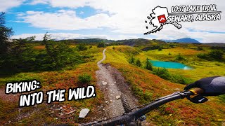
trail: Lost Lake Trail
5:33 |
237 |
Jul 6, 2020
trail: Lost Lake Trail
0:55 |
331 |
Sep 24, 2018
trail: Lost Lake Trail
0:27 |
219 |
Oct 2, 2016
trail: Lost Lake Trail
4:33 |
238 |
Jul 20, 2016
trail: Lost Lake Trail
5:22 |
579 |
Oct 24, 2012
trail: Lost Lake Trail
14:09 |
87 |
Feb 17, 2025 , Seward
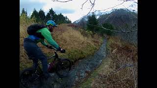
trail: Lost Lake Trail
3:26 |
250 |
Sep 12, 2022 , Seward
youtuber
![Why Summer in Alaska is a mixed bag.]()
trail: Lost Lake Trail
15:08 |
327 |
Sep 8, 2022 , Seward
Current Trail Warnings
| status | trail | date | condition | user | info |
|---|---|---|---|---|---|
| Mount Marathon Trail | Jun 12, 2026 @ 12:57pm (America/Anchorage) Jun 12, 2026 | Ideal | benmathews | Hike technically closed though the city... | |
| Slutty Fuel | Jun 12, 2026 @ 12:57pm (America/Anchorage) Jun 12, 2026 | Wet | benmathews | Hike deadfalls and high water make this... | |
| Flip Flop | Jun 12, 2026 @ 12:57pm (America/Anchorage) Jun 12, 2026 | Ideal | benmathews | Hike |
Recent Trail Reports
| status | trail | date | condition | info | user |
|---|---|---|---|---|---|
| Meridian Lakes (Iditarod NHT) | Jun 18, 2026 @ 7:22am (America/Anchorage) Jun 18, 2026 | Ideal | Brantgrifka | ||
| Lower Fairy Forest | Jun 12, 2026 @ 12:57pm (America/Anchorage) Jun 12, 2026 | Ideal | benmathews | ||
| Lost Lake Trail | Jun 4, 2026 @ 11:26am (America/Anchorage) Jun 4, 2026 | Variable | RyanBoBr0a | ||
| Resurrection Bay Bike Path | Sep 2, 2025 @ 7:44am Sep 2, 2025 | Unknown | Slocum | ||
| Caines Head - Coastal Trail | Aug 1, 2025 @ 11:29am Aug 1, 2025 | Variable | icthus13 SanFelasco | ||
| INHT - Primrose Trail | Aug 4, 2024 @ 8:31pm Aug 4, 2024 | Dry | wolfdoodle5017 | ||
| Lost Lake Spur | Jul 17, 2024 @ 5:26am Jul 17, 2024 | Wet | bam907 | ||
| Up to lost | Jul 17, 2024 @ 5:26am Jul 17, 2024 | Wet | bam907 | ||
| Ptarmigan Creek Trailhead | Jun 19, 2024 @ 2:22pm Jun 19, 2024 | Ideal | ceqinak | ||
| Skyline Trail | Jun 15, 2024 @ 2:33am Jun 15, 2024 | Snow Cover Partial | VanessaGC0bHY |
Activity Feed
| username | action | type | title | date |
|---|---|---|---|---|
| Knsuhlir | ridden | trail | activity #97566539 | Jun 22, 2026 @ 9:18am 24 hours |
| michael1969 | ridden | trail | activity #97421679 | Jun 20, 2026 @ 12:15pm 3 days |
| Brantgrifka | add | report | activity #97265213 | Jun 18, 2026 @ 11:24am Jun 18, 2026 |
| lreeger | wishlist | trail | activity #97233925 | Jun 17, 2026 @ 10:58pm Jun 17, 2026 |
| KathyMc | add | photo | activity #97107519 and 2 more | Jun 16, 2026 @ 7:09am Jun 16, 2026 |
Recent Comments
| username | type | title | comment | date |
|---|---|---|---|---|
| trail | This is not a mountain bike trail it’s is to... | May 31, 2025 @ 2:13pm May 31, 2025 | ||
| trail | Haha not arguing with the... | May 2, 2025 @ 1:37pm May 2, 2025 | ||
| trail | Fantastic trail for MTB. A tough uphill but... | Jul 8, 2024 @ 6:51pm Jul 8, 2024 | ||
| trail | Surprisingly fun MTB ride if you happen to be... | Jul 8, 2024 @ 6:48pm Jul 8, 2024 | ||
| trail | Having run this ill say that this really is... | Jul 8, 2024 @ 6:47pm Jul 8, 2024 |
Local Badges
-

10 Blue Trails2 awarded -

Epic Mountain Bike Climb 2k11 awarded -

Climbing 10k Badge3 awarded -

Mountain Biking 100k Badge0 awarded -

Epic Ride Descent 2k11 awarded -

Descent 10k Badge3 awarded
Bike & Skill Parks
| name | type | city | rating |
|---|---|---|---|
| Seward Community Bike Park | skill park | Seward |
Activity Type Stats
| activitytype | trails | distance | descent | descent distance | total vertical | rating | global rank | state rank | photos | reports | routes | ridelogs |
|---|---|---|---|---|---|---|---|---|---|---|---|---|
| Mountain Bike | 43 | 76 miles | 10,571 ft | 29 miles | 2,848 ft | #2,953 | #1,039 | 62 | 53 | 1,588 | ||
| E-Bike | 8 | 6 miles | 26 ft | 1 mile | 453 ft | #7,024 | #2,117 | 38 | 19 | |||
| Hike | 56 | 88 miles | 11,604 ft | 31 miles | 3,517 ft | #2,666 | #1,025 | 9 | 53 | 2 | 1,421 | |
| Trail Running | 56 | 88 miles | 11,604 ft | 31 miles | 3,517 ft | #2,707 | #769 | 53 | 289 | |||
| ATV/ORV/OHV | 2 | 1,726 ft | 151 ft | 16 ft | 5 | |||||||
| Snowshoe | 8 | 6 miles | 564 ft | 1 mile | 3,517 ft | #1,085 | #551 | 1 | 6 | |||
| Backcountry Ski | 8 | 6 miles | 564 ft | 1 mile | 3,517 ft | #560 | #169 | 26 |
Frequently Asked Questions About Seward
▼
What are the best places to ride in Seward?
Seward has 3 areas to explore for mountain biking. The top rated areas are:
▼
What are the highest rated mountain biking trails in Seward?
The highest rated mountain biking trails in Seward are:
- Lost Lake Trail (4.6/5)
- Meridian Lakes (Iditarod NHT) (4.2/5)
- Finger Blaster (4.1/5)
- Seward Highway Bike Path (4.1/5)
- Skyline Trail (3.7/5)
▼
What is the best time of the year to ride in Seward?
Based on ride log data, the most popular months to ride in Seward are:
- July (46 activities)
- August (27 activities)
- June (25 activities)
▼
Where can I park to ride in Seward?
There are 12 parking locations listed in Seward. The most popular parking spots are: View all parking and trailhead locations on the map to plan your visit.
Activities
Trails
Points of Interest
- By mtnjnkie
 TRAILFORKS STA & contributors
 - Admins: WillTaygan, A-Lens-for-Wanderlust, PetersXdgWu
- #19686 - 6,162 views
- seward activity log | embed map of Seward mountain bike trails | seward mountain biking points of interest polygons
Downloading of trail gps tracks in kml & gpx formats is enabled for Seward.
You must login to download files.