close
-
Layers w
- Weather Layers
- Pro
- Pro
- Pro
- Pro
- Pro
- Pro
- More Layers
- Pro
- Pro
- Pro
- Pro
-
Upgrade to

3D
Trail Conditions
- Unknown
- Snow Groomed
- Snow Packed
- Snow Covered
- Snow Cover Partial
- Freeze/thaw Cycle
- Icy
- Prevalent Mud
- Wet
- Variable
- Ideal
- Dry
- Very Dry
Trail Flow (Ridden Direction)
Trailforks scans users ridelogs to determine the most popular direction each trail is ridden. A good flowing trail network will have most trails flowing in a single direction according to their intension.
The colour categories are based on what percentage of riders are riding a trail in its intended direction.
The colour categories are based on what percentage of riders are riding a trail in its intended direction.
- > 96%
- > 90%
- > 80%
- > 70%
- > 50%
- < 50%
- bi-directional trail
- no data
Trail Last Ridden
Trailforks scans ridelogs to determine the last time a trail was ridden.
- < 2 days
- < 1 week
- < 2 weeks
- < 1 month
- < 6 months
- > 6 months
Trail Ridden Direction
The intended direction a trail should be ridden.
- Downhill Only
- Downhill Primary
- Both Directions
- Uphill Primary
- Uphill Only
- One Direction
Contribute Details
Colors indicate trail is missing specified detail.
- Description
- Photos
- Description & Photos
- Videos
Trail Popularity ?
Trailforks scans ridelogs to determine which trails are ridden the most in the last 9 months.
Trails are compared with nearby trails in the same city region with a possible 25 colour shades.
Think of this as a heatmap, more rides = more kinetic energy = warmer colors.
- most popular
- popular
- less popular
- not popular
ATV/ORV/OHV Filter
Max Vehicle Width
inches
US Cell Coverage
Legend

Radar Time
Activity Recordings
Trailforks uses anonymized public activity data.
?
Activity Recordings
Trailforks uses anonymized public activity data.
?
Personal Heatmap
▶
Activity Types
all
/
none
▶
Options
2
Date range
month
–
Winter Trails
Warning
A routing network for winter maps does not exist. Selecting trails using the winter trails layer has been disabled.
Missing Trails
Most Popular
Least Popular
Trails are colored based on popularity. The more popular a trail is, the more red. Less popular trails trend towards green.
Jump Magnitude Heatmap
Heatmap of where riders jump on trails. Zoom in to see individual jumps, click circles to view jump details.
BC Backroad Status
![map legend]()
Service Road Atlas is a free to use, community-driven service for viewing and creating reports on the numerous back-country service roads around B.C. and Alberta.

Slope Aspect
Direction the slope faces
Trails Deemphasized
Trails are shown in grey.
Only show trails with no bike usage.
Suggested Layers
Based on selected activity type
Save the current map location and zoom level as your default home location whenever this page is loaded.
SaveSharlands forestry area has a wide variety of hand-built trails through forestry and native plantation with everything from a technical single track, steep loamy descents, and national level DH tracks. Forestry roads link the network for the gravel grinders. A great all-weather riding area.
 google parking directions
 Access Info:
The gate has two parts; A high gate and a low gate. You can enter when the high is open and the low gate is closed. This area is maintained by the Nelson Mountain Bike Club. Please consider supporting the club.
Activities Click to view
- Mountain Bike
40 trails
- E-Bike
32 trails
- Hike
32 trails
- Trail Running
32 trails
Region Details
- 18
- 2
- 4
- 7
- 4
Region Status
Caution as of Jun 13, 2026Stats
- Avg Trail Rating
- Trails (view details)
- 38
- Trails Mountain Bike
- 40
- Trails E-Bike
- 32
- Trails Hike
- 32
- Trails Trail Running
- 32
- Total Distance
- 47 miles
- Total Descent
- 13,991 ft
- Total Vertical
- 1,740 ft
- Highest Trailhead
- 1,871 ft
- Reports
- 1,848
- Photos
- 312
- Ridden Counter
- 8,615
Popular Waitarake/Sharlands Mountain Biking Trails
• 50 ★ 4.0 • 3,577 ft • 39 ft • 428 • • mtb
is the easiest track in the Sharland Valley Trail System. Staring roughly 1.2km up Sharland road, drop down the short hill and look for a turn to the right. This is the entrance to the track. follows the river down, starting with a...
• 70 ★ 4.6 • 3,468 ft • 0 ft • 424 • • mtb
A sweet narrow off camber dream, dropping corners, some berms, in forest. Built by Hamish, Kurt, Liv, Easy, Loui and a heap of others
• 75 ★ 4.6 • 3,038 ft • 10 ft • 422 • • mtb
An off-camber, barely benched swooping fun trail. Naturaly extends either the top of Face or . Finishes on the Valley road at the same spot as and Maitai Face. Lead builders were Kurt, Liv, Hamish and Easy. New trail grade in 2021
• 85 ★ 4.7 • 2,234 ft • 0 ft • 417 • • mtb
lives up to its name as it drops, literally, down through the exotic forest through a number of switchbacks, dropping corners and fast paced descents. With easy access and just being soooo damn good, will see you back around to do it...
• 45 ★ 4.1 • 3,711 ft • 15 ft • 288 • • mtb
is a classic Nelson track. Built in a beautiful DoC managed area of native bush it's challenging but not too steep, rides well all year round. Mostly rock base it has some tight corners but is mostly flowing. Joins up with the Sharlands...
• 35 ★ 3.6 • 4,367 ft • 12 ft • 259 • • mtb
A continuation of the Sharland Valley trail leading on from the 'Wiggles' & 'Waggles'. Fast, flowy and easy in the grade. Leads into ' ' and back to the trail head.
• 30 ★ 3.4 • 3,495 ft • 28 ft • 153 • • mtb
Short technical single track through native forest.
• 45 ★ 4.5 • 2,438 ft • 0 ft • 147 • • mtb
Maitai Face (full) is a steep, well made downhill track that is also trail bike friendly. It's super steep in places (over 50%). Built in pine forest it's off camber, rooty, has steep corners and is challenging. In the dry it has loads...
Waitarake/Sharlands Mountain Bike Routes
32 miles • 3,102 ft • 5 • Loop •
Awesome Gravel Road Loop Make sure you stop at Hira Dairy for an Ice Cream ( see POI) Please check the...
50 miles • 14,596 ft • 29 •
This is a true experience of Nelson and its trails
• 5 miles • 1,327 ft • 4 •
• 3 miles • 802 ft • 1 •
• 5 miles • 1,535 ft • 4 •
• 10 miles • 2,281 ft • 4 •
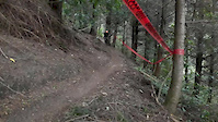
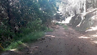
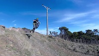
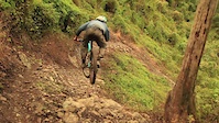
Photos of Waitarake/Sharlands Mountain Bike
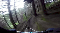
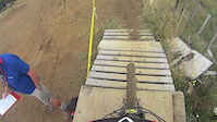
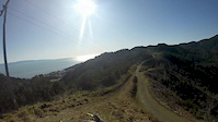
Videos of Waitarake/Sharlands Mountain Bike
trail: Mr Chomper
0:00 |
532 |
Dec 18, 2017
trail: Maitai Face (full)
2:53 |
215 |
Dec 18, 2017
trail: Sharlands Creek
0:50 |
30526 |
Aug 26, 2017
trail: Putakari
3:41 |
1382 |
Apr 22, 2017

trail: Broken Axe
5:03 |
445 |
Jul 17, 2016
trail: Maitai Face (full)
5:53 |
255 |
Jul 17, 2016
trail: Kaka
3:45 |
967 |
Feb 12, 2016
trail: Broken Axe
0:42 |
417 |
Jul 19, 2015
Current Trail Warnings
| status | trail | date | condition | user | info |
|---|---|---|---|---|---|
| Maitai Face (full) | Jun 13, 2026 @ 8:13pm (Pacific/Auckland) Jun 13, 2026 | Unknown | BevanR | lower Maitai face. a lot of windfall and... | |
| Central Rd | Jun 9, 2026 @ 2:00pm (Pacific/Auckland) Jun 8, 2026 | Unknown | NMTBC NMTBC | Central Road access is closed from... |
Recent Trail Reports
| status | trail | date | condition | info | user |
|---|---|---|---|---|---|
| What The DOC Ordered | Jun 9, 2026 @ 1:58pm (Pacific/Auckland) Jun 8, 2026 | Unknown | NMTBC NMTBC | ||
| Supplejack | Jun 9, 2026 @ 1:58pm (Pacific/Auckland) Jun 8, 2026 | Unknown | NMTBC NMTBC | ||
| Sharlands Creek | Jun 9, 2026 @ 1:58pm (Pacific/Auckland) Jun 8, 2026 | Unknown | NMTBC NMTBC | ||
| Rimu | Jun 9, 2026 @ 1:58pm (Pacific/Auckland) Jun 8, 2026 | Unknown | NMTBC NMTBC | ||
| Matai Climb | Jun 9, 2026 @ 1:58pm (Pacific/Auckland) Jun 8, 2026 | Unknown | NMTBC NMTBC | ||
| Matai | Jun 9, 2026 @ 1:58pm (Pacific/Auckland) Jun 8, 2026 | Unknown | NMTBC NMTBC | ||
| Kaka Road | Jun 9, 2026 @ 1:58pm (Pacific/Auckland) Jun 8, 2026 | Unknown | NMTBC NMTBC | ||
| Slaters Road | May 10, 2026 @ 1:17pm (Pacific/Auckland) May 9, 2026 | Unknown | Haggiss | ||
| Waterloo | May 2, 2026 @ 4:18pm (Pacific/Auckland) May 1, 2026 | Unknown | NMTBC NMTBC | ||
| Sharlands Super-Skid shortcut | May 2, 2026 @ 4:18pm (Pacific/Auckland) May 1, 2026 | Unknown | NMTBC NMTBC |
Activity Feed
| username | action | type | title | date |
|---|---|---|---|---|
| Benn3V39V | difficultyvote | trail | activity #97071392 | Jun 15, 2026 @ 4:06pm Jun 15, 2026 |
| BevanR | add | report | activity #96853422 | Jun 13, 2026 @ 1:13am Jun 13, 2026 |
| NMTBC | add | report | activity #96579568 and 7 more | Jun 8, 2026 @ 6:58pm Jun 8, 2026 |
| Jaydenfriend | wishlist | route | activity #96341470 | Jun 5, 2026 @ 9:10pm Jun 5, 2026 |
| JoshuawHXuev | ridden | route | activity #95360628 | May 23, 2026 @ 3:36pm May 23, 2026 |
Recent Comments
| username | type | title | comment | date |
|---|---|---|---|---|
| trail | Putakari is in a very bad state with loads of... | Jan 1, 2026 @ 9:00pm Jan 1, 2026 | ||
| trail | Running so good right now! Trail fairies have... | Dec 29, 2025 @ 2:23am Dec 29, 2025 | ||
| trail | Don't attempt as logging and zero trail... | Oct 26, 2025 @ 5:23pm Oct 26, 2025 | ||
| trail | Large tree down about half way down. Difficult... | Feb 21, 2025 @ 8:52pm Feb 21, 2025 | ||
| trail | Should have checked the comments here. Start... | Jan 12, 2025 @ 7:36pm Jan 12, 2025 |
Nearby Areas
| name | distance | ||||
|---|---|---|---|---|---|
| Koata Park (formerly Maitai-Codgers) | 3 | 7 | 3 | 2.1 km | |
| Codgers | 4 | 2.5 km | |||
| Coppermine | 2 | 3 km | |||
| Fringed Hill Nelson | 4 | 9 | 3.2 km | ||
| The Grampians | 1 | 3 | 3.8 km |
Local Badges
-

Completionist0 awarded
Activity Type Stats
| activitytype | trails | distance | descent | descent distance | total vertical | rating | global rank | state rank | photos | reports | routes | ridelogs |
|---|---|---|---|---|---|---|---|---|---|---|---|---|
| Mountain Bike | 40 | 47 miles | 13,993 ft | 23 miles | 1,739 ft | #1,434 | #51 | 307 | 1,847 | 2 | 7,480 | |
| E-Bike | 32 | 4 miles | 1,309 ft | 2 miles | 1,171 ft | #2,751 | #73 | 1,241 | 1 | 715 | ||
| Hike | 32 | 41 miles | 7,671 ft | 18 miles | 1,739 ft | #3,452 | #57 | 1,570 | 1 | 48 | ||
| Trail Running | 32 | 41 miles | 7,671 ft | 18 miles | 1,739 ft | #2,655 | #44 | 2 | 1,570 | 1 | 113 |
Frequently Asked Questions About Waitarake/Sharlands
▼
What are the highest rated mountain biking trails in Waitarake/Sharlands?
The highest rated mountain biking trails in Waitarake/Sharlands are:
- Aorere (4.6/5)
- Putakari (4.6/5)
- Loam Ranger (4.5/5)
- Keyboard Warrior (4.4/5)
- Mr Chomper (4.4/5)
▼
What is the best time of the year to ride in Waitarake/Sharlands?
Based on ride log data, the most popular months to ride in Waitarake/Sharlands are:
- February (30 activities)
- April (26 activities)
- December (26 activities)
▼
Where can I park to ride in Waitarake/Sharlands?
There are 1 parking locations listed in Waitarake/Sharlands. The most popular parking spots are:
▼
What is the longest trail in Waitarake/Sharlands?
The longest trail in Waitarake/Sharlands is Aorere at 4.1 km. View all trails sorted by distance.
Activities
- By bradical9 & contributors
- Admins: Aorere-Enduro, NelsonCouncil, NMTBC, tamallama, easy-trail
- #6655 - 22,773 views
- waitarake/sharlands activity log | embed map of Waitarake/Sharlands mountain bike trails | waitarake/sharlands mountain biking points of interest polygons
Downloading of trail gps tracks in kml & gpx formats is enabled for Waitarake/Sharlands.
You must login to download files.