close
-
Layers w
- Weather Layers
- Pro
- Pro
- Pro
- Pro
- Pro
- Pro
- More Layers
- Pro
- Pro
- Pro
- Pro
-
Upgrade to

3D
Trail Conditions
- Unknown
- Snow Groomed
- Snow Packed
- Snow Covered
- Snow Cover Partial
- Freeze/thaw Cycle
- Icy
- Prevalent Mud
- Wet
- Variable
- Ideal
- Dry
- Very Dry
Trail Flow (Ridden Direction)
Trailforks scans users ridelogs to determine the most popular direction each trail is ridden. A good flowing trail network will have most trails flowing in a single direction according to their intension.
The colour categories are based on what percentage of riders are riding a trail in its intended direction.
The colour categories are based on what percentage of riders are riding a trail in its intended direction.
- > 96%
- > 90%
- > 80%
- > 70%
- > 50%
- < 50%
- bi-directional trail
- no data
Trail Last Ridden
Trailforks scans ridelogs to determine the last time a trail was ridden.
- < 2 days
- < 1 week
- < 2 weeks
- < 1 month
- < 6 months
- > 6 months
Trail Ridden Direction
The intended direction a trail should be ridden.
- Downhill Only
- Downhill Primary
- Both Directions
- Uphill Primary
- Uphill Only
- One Direction
Contribute Details
Colors indicate trail is missing specified detail.
- Description
- Photos
- Description & Photos
- Videos
Trail Popularity ?
Trailforks scans ridelogs to determine which trails are ridden the most in the last 9 months.
Trails are compared with nearby trails in the same city region with a possible 25 colour shades.
Think of this as a heatmap, more rides = more kinetic energy = warmer colors.
- most popular
- popular
- less popular
- not popular
ATV/ORV/OHV Filter
Max Vehicle Width
inches
US Cell Coverage
Legend

Radar Time
Activity Recordings
Trailforks uses anonymized public activity data.
?
Activity Recordings
Trailforks uses anonymized public activity data.
?
Personal Heatmap
▶
Activity Types
all
/
none
▶
Options
2
Date range
month
–
Winter Trails
Warning
A routing network for winter maps does not exist. Selecting trails using the winter trails layer has been disabled.
Missing Trails
Most Popular
Least Popular
Trails are colored based on popularity. The more popular a trail is, the more red. Less popular trails trend towards green.
Jump Magnitude Heatmap
Heatmap of where riders jump on trails. Zoom in to see individual jumps, click circles to view jump details.
BC Backroad Status
![map legend]()
Service Road Atlas is a free to use, community-driven service for viewing and creating reports on the numerous back-country service roads around B.C. and Alberta.

Slope Aspect
Direction the slope faces
Trails Deemphasized
Trails are shown in grey.
Only show trails with no bike usage.
Suggested Layers
Based on selected activity type
Save the current map location and zoom level as your default home location whenever this page is loaded.
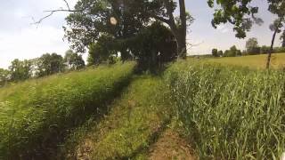
SaveOne of the most scenic of the Potawatomi Chapter’s trails, this easy loop provides sweeping vistas of rolling farmlands and the opportunity to ride scenic singletrack along the banks of the Raisin River. The property on which the trial is located is owned by Washtenaw County, and is part of the Sharon Mills Park. The trail runs counter-clockwise and heads west in an undulating series of turns and twists as it passes through fallow farmland and next to small wetlands. As it turns south it runs parallel to the Nan Weston Preserve of the Nature Conservancy, home to a variety of interesting plants and wildlife. Deer, turkeys, wood ducks and sandhill cranes are frequent visitors to the park. As the trail approaches the Raisin River it parallels an old road bed and snakes back and forth under a canopy of old oaks and other trees left from the pioneer farming days. The character of the trailbed changes significantly in this area, as it becomes tighter, more twisty and with continuous changes in elevation that hold the rider’s interest. Once on the south side of the old roadbed the terrain slopes gently to the impoundment formed by the dam at the mill site. The ride along the banks of the Raisin River in this area is especially picturesque, particularly in the early morning or evening, made more so by being entirely single-track. At the eastern end of the park the trail turns north and heads back to the parking lot, climbing some hills as it leaves the river valley in the process.
After a ride it’s always nice to stop by the mill site a quarter mile south on Sharon Hollow Road to sit by the river, get a drink of water, or to use the restrooms.
After a ride it’s always nice to stop by the mill site a quarter mile south on Sharon Hollow Road to sit by the river, get a drink of water, or to use the restrooms.
source: MMBA
Primary Trail Type: Cross-Country
 google parking directions
 Access Info:
Sharon Township, northwest of Manchester. Trailhead parking lot is located on the west side of the intersection of Pleasant Lake Road and Sharon Hollow Road.
Activities Click to view
- Mountain Bike
3 trails
- Hike
7 trails
- Trail Running
7 trails
Region Details
- 1
- 2
Region Status
Open as of Jun 8, 2024Stats
- Avg Trail Rating
- Trails (view details)
- 6
- Trails Mountain Bike
- 3
- Trails Hike
- 7
- Trails Trail Running
- 7
- Total Distance
- 6 miles
- Total Descent
- 340 ft
- Total Vertical
- 79 ft
- Highest Trailhead
- 983 ft
- Reports
- 17
- Photos
- 35
- Ridden Counter
- 64
Popular Sharon Mills Mountain Biking Trails
• 90 ★ 0.0 • 4,889 ft • 55 ft • 12 •
Popular green difficulty mixed. This multi-use trail can be used both directions. Trail visibility is always easy to follow. On average it takes 8 minutes to complete this trail.
Videos of Sharon Mills Mountain Bike

0:00 |
312 |
Jan 23, 2020 , Manchester
3:06 |
371 |
Jan 23, 2020 , Manchester
Recent Trail Reports
| status | trail | date | condition | info | user |
|---|---|---|---|---|---|
| Hill Loop | Nov 3, 2023 @ 6:46pm Nov 3, 2023 | Dry | garbagefan MMMBA | ||
| Daytime Parking and Bathroom at Sharon Mills County Park | Dec 2, 2019 @ 1:00pm Dec 2, 2019 | Unknown | EricCooper |
Activity Feed
| username | action | type | title | date |
|---|---|---|---|---|
| TrevorzAoxEp | wishlist | trail | activity #58761759 | Sep 12, 2024 @ 2:33pm Sep 12, 2024 |
| cathau5 | wishlist | trail | activity #52892804 and 1 more | May 20, 2024 @ 11:53am May 20, 2024 |
| garbagefan | add | report | activity #45875379 | Nov 3, 2023 @ 6:49pm Nov 3, 2023 |
| garbagefan | add | photo | activity #45874506 and 1 more | Nov 3, 2023 @ 6:21pm Nov 3, 2023 |
| TempleBuilder | add | photo | activity #19063784 | May 13, 2021 @ 11:45am May 13, 2021 |
Recent Comments
| username | type | title | comment | date |
|---|---|---|---|---|
| trail | Two big trees tipped across the lower section... | Oct 27, 2019 @ 7:38pm Oct 27, 2019 |
Nearby Areas
| name | distance | ||||
|---|---|---|---|---|---|
| Watson Lake State Park | 5 | 3.8 km | |||
| Grass Lake Park | 2 | 3 | 7.9 km | ||
| DTE Energy Foundation Trail | 1 | 2 | 1 | 11 km | |
| Ella Sharp | 9 | 7 | 16.2 km | ||
| Heritage Park | 3 | 4 | 18.1 km |
Activity Type Stats
| activitytype | trails | distance | descent | descent distance | total vertical | rating | global rank | state rank | photos | reports | routes | ridelogs |
|---|---|---|---|---|---|---|---|---|---|---|---|---|
| Mountain Bike | 3 | 4 miles | 266 ft | 1 mile | 79 ft | #17,589 | #7,397 | 8 | 11 | 144 | ||
| Hike | 7 | 6 miles | 341 ft | 2 miles | 79 ft | #823 | #422 | 3 | 17 | 11 | ||
| Trail Running | 7 | 6 miles | 341 ft | 2 miles | 79 ft | #216 | #109 | 24 | 17 | 20 |
Frequently Asked Questions About Sharon Mills
▼
What are the highest rated mountain biking trails in Sharon Mills?
The highest rated mountain biking trails in Sharon Mills are:
- Hill Loop (0/5)
- River Loop (0/5)
▼
What is the best time of the year to ride in Sharon Mills?
Based on ride log data, the most popular months to ride in Sharon Mills are:
- August (1 activities)
▼
Where can I park to ride in Sharon Mills?
There are 3 parking locations listed in Sharon Mills. The most popular parking spots are: View all parking and trailhead locations on the map to plan your visit.
▼
What is the longest trail in Sharon Mills?
The longest trail in Sharon Mills is Hill Loop at 2.7 miles. View all trails sorted by distance.
- By markholloway
 Trailforks Map Team & contributors
 - Admins: PotoMBA, PotoMBA, PotoMBA
- #11606 - 3,544 views
- sharon mills activity log | embed map of Sharon Mills mountain bike trails | sharon mills mountain biking points of interest
Downloading of trail gps tracks in kml & gpx formats is enabled for Sharon Mills.
You must login to download files.