close
-
Layers w
- Weather Layers
- Pro
- Pro
- Pro
- Pro
- Pro
- Pro
- More Layers
- Pro
- Pro
- Pro
- Pro
-
Upgrade to

3D
Trail Conditions
- Unknown
- Snow Groomed
- Snow Packed
- Snow Covered
- Snow Cover Partial
- Freeze/thaw Cycle
- Icy
- Prevalent Mud
- Wet
- Variable
- Ideal
- Dry
- Very Dry
Trail Flow (Ridden Direction)
Trailforks scans users ridelogs to determine the most popular direction each trail is ridden. A good flowing trail network will have most trails flowing in a single direction according to their intension.
The colour categories are based on what percentage of riders are riding a trail in its intended direction.
The colour categories are based on what percentage of riders are riding a trail in its intended direction.
- > 96%
- > 90%
- > 80%
- > 70%
- > 50%
- < 50%
- bi-directional trail
- no data
Trail Last Ridden
Trailforks scans ridelogs to determine the last time a trail was ridden.
- < 2 days
- < 1 week
- < 2 weeks
- < 1 month
- < 6 months
- > 6 months
Trail Ridden Direction
The intended direction a trail should be ridden.
- Downhill Only
- Downhill Primary
- Both Directions
- Uphill Primary
- Uphill Only
- One Direction
Contribute Details
Colors indicate trail is missing specified detail.
- Description
- Photos
- Description & Photos
- Videos
Trail Popularity ?
Trailforks scans ridelogs to determine which trails are ridden the most in the last 9 months.
Trails are compared with nearby trails in the same city region with a possible 25 colour shades.
Think of this as a heatmap, more rides = more kinetic energy = warmer colors.
- most popular
- popular
- less popular
- not popular
ATV/ORV/OHV Filter
Max Vehicle Width
inches
US Cell Coverage
Legend

Radar Time
Activity Recordings
Trailforks uses anonymized public activity data.
?
Activity Recordings
Trailforks uses anonymized public activity data.
?
Personal Heatmap
▶
Activity Types
all
/
none
▶
Options
2
Date range
month
–
Winter Trails
Warning
A routing network for winter maps does not exist. Selecting trails using the winter trails layer has been disabled.
Missing Trails
Most Popular
Least Popular
Trails are colored based on popularity. The more popular a trail is, the more red. Less popular trails trend towards green.
Jump Magnitude Heatmap
Heatmap of where riders jump on trails. Zoom in to see individual jumps, click circles to view jump details.
BC Backroad Status
![map legend]()
Service Road Atlas is a free to use, community-driven service for viewing and creating reports on the numerous back-country service roads around B.C. and Alberta.

Slope Aspect
Direction the slope faces
Trails Deemphasized
Trails are shown in grey.
Only show trails with no bike usage.
Suggested Layers
Based on selected activity type
Save the current map location and zoom level as your default home location whenever this page is loaded.
Save
No description for Shawinigan has been added yet!
Login or register to submit one.
Activities Click to view
- Mountain Bike
42 trails
- E-Bike
18 trails
- Adaptive Bike
0 trails
- Winter Fat Bike
0 trails
- Hike
34 trails
- Trail Running
34 trails
- Snowshoe
20 trails
- Nordic Ski
14 trails
Region Details
- 1
- 7
- 11
- 14
- 3
Region Status
Open as of Mar 9, 2026Local Trail Association
Stats
- Avg Trail Rating
- Trails (view details)
- 40
- Trails Mountain Bike
- 43
- Trails E-Bike
- 18
- Trails Hike
- 34
- Trails Trail Running
- 34
- Trails Snowshoe
- 20
- Trails Nordic Ski
- 14
- Total Distance
- 17 miles
- Total Descent Distance
- 8 miles
- Total Descent
- 2,057 ft
- Total Vertical
- 261 ft
- Highest Trailhead
- 370 ft
- Reports
- 58
- Photos
- 76
- Ridden Counter
- 947
Sub Regions
-
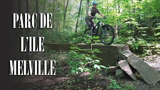
Parc de L'Île Melville (secteur des chutes)
- 6
- 10
- 14
- 3
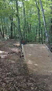
Popular Shawinigan Mountain Biking Trails
• 85 ★ 3.8 • 3,058 ft • 126 ft • 69 •
Popular black diamond difficulty singletrack. This mountain bike primary trail and has a hard overall physical rating with a 126 ft black diamond climb. It features rock face, rock garden and other. Trail visibility is sometimes hard to follow. On average it takes 9 minutes to complete this trail.
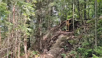
• 95 ★ 4.0 • 1 mile • 103 ft • 67 •
Popular black diamond difficulty singletrack. This mountain bike primary trail can be used one direction and has a hard overall physical rating with a 103 ft black diamond climb. It features bridge, jump, rock face and rock garden. Trail visibility is sometimes hard to follow. On average it takes 15 minutes to complete this trail.
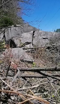
• 90 ★ 3.0 • 4,035 ft • 4 ft • 58 •
Popular blue difficulty singletrack. This mountain bike primary trail can be used downhill primary and has a moderate overall physical rating with a 4 ft blue climb. It features drop, jump, gap jump, rock face and rock garden. Trail visibility is sometimes hard to follow. On average it takes 8 minutes to complete this trail.
• 90 ★ 5.0 • 3,346 ft • 90 ft • 55 •
Popular blue difficulty singletrack. This mountain bike primary trail. On average it takes 12 minutes to complete this trail.
• 100 ★ 5.0 • 889 ft • 3 ft • 48 •
Popular double black diamond difficulty singletrack. This mountain bike primary trail can be used one direction. It features drop, jump, gap jump, rock face and rock garden. Trail visibility is always easy to follow. On average it takes 1 minutes to complete this trail.
• 60 ★ 0.0 • 3,176 ft • 19 ft • 43 •
Sentier de vers les stationnements du parc de l'Île Melville (secteur des chutes)
• 70 ★ 3.5 • 3,612 ft • 40 ft • 34 •
Popular black diamond difficulty singletrack. This multi-use trail. It features rock garden. On average it takes 10 minutes to complete this trail.
• 65 ★ 3.5 • 617 ft • 28 ft • 33 •
Moderately popular blue difficulty singletrack. This mountain bike primary trail can be used both directions and has a moderate overall physical rating with a 28 ft blue climb. It features jump, gap jump and rock face. Trail visibility is sometimes hard to follow. On average it takes minutes to complete this trail.
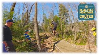
Shawinigan Mountain Bike Routes
Photos of Shawinigan Mountain Bike
Videos of Shawinigan Mountain Bike
trail: Les Sauts
0:08 |
71 |
Aug 20, 2025
trail: La Double D
0:06 |
31 |
Oct 29, 2024
trail: La Double D
0:07 |
54 |
Oct 29, 2024

trail: Les Sauts
0:07 |
34 |
Oct 29, 2024
youtuber
![1er épisode de 2026 - On Ride Le Parc de...]()
12:48 |
39 |
May 25, 2026

trail: La B
1:1:58 |
181 |
Aug 31, 2023 , Shawinigan

trail: Les Jeux du Québec
1:1:58 |
333 |
Aug 31, 2023 , Shawinigan
trail: L'Obligation
1:1:58 |
199 |
Aug 31, 2023 , Shawinigan
Recent Trail Reports
| status | trail | date | condition | info | user |
|---|---|---|---|---|---|
| La B | Oct 21, 2024 @ 5:24pm Oct 21, 2024 | Ideal | ChristianBeland CLUBVMDC | ||
| La boucle à Mily | Sep 15, 2024 @ 11:56am Sep 15, 2024 | Ideal | LPBikehard | ||
| La B (Slab) | Sep 13, 2024 @ 5:05am Sep 13, 2024 | Ideal | ChristianBeland CLUBVMDC | ||
| Les Jeux du Québec | Aug 29, 2024 @ 6:35am Aug 29, 2024 | Prevalent Mud | jon-lemire | ||
| La Val-Mo | Aug 15, 2024 @ 5:53am Aug 15, 2024 | Ideal | ChristianBeland CLUBVMDC | ||
| Retour Stationnement | Aug 15, 2024 @ 5:52am Aug 15, 2024 | Ideal | ChristianBeland CLUBVMDC | ||
| La FLATeuse | Aug 15, 2024 @ 5:51am Aug 15, 2024 | Variable | ChristianBeland CLUBVMDC | ||
| La Roche à Denis | Aug 15, 2024 @ 5:46am Aug 15, 2024 | Ideal | ChristianBeland CLUBVMDC | ||
| chemin des chutes | Aug 15, 2024 @ 5:46am Aug 15, 2024 | Ideal | ChristianBeland CLUBVMDC | ||
| L'Obligation | Aug 15, 2024 @ 5:46am Aug 15, 2024 | Ideal | ChristianBeland CLUBVMDC |
Activity Feed
| username | action | type | title | date |
|---|---|---|---|---|
| trailforks | add | video | activity #95499141 | May 25, 2026 @ 10:00am May 25, 2026 |
| StephCotnoirMTB | wishlist | region | activity #94477665 | May 10, 2026 @ 9:32pm May 10, 2026 |
| ChristianBeland | update | trail | activity #86359358 and 5 more | Dec 30, 2025 @ 6:01pm Dec 30, 2025 |
| ChristianBeland | update | trail | activity #84982151 and 3 more | Nov 30, 2025 @ 12:17pm Nov 30, 2025 |
| ChristianBeland | update | trail | activity #84965303 and 3 more | Nov 30, 2025 @ 7:28am Nov 30, 2025 |
Local Badges
-

Epic Mountain Bike Climb 2k0 awarded -

Climbing 10k Badge3 awarded -

Mountain Biking 100k Badge0 awarded -

Epic Ride Descent 2k0 awarded -

Descent 10k Badge5 awarded -

Descent 100k Badge0 awarded
Bike & Skill Parks
| name | type | city | rating |
|---|---|---|---|
| BMX Shawi | skill park | Shawinigan | |
| Pump Track - Parc Turcotte | skill park | Shawinigan |
Activity Type Stats
| activitytype | trails | distance | descent | descent distance | total vertical | rating | global rank | state rank | photos | reports | routes | ridelogs |
|---|---|---|---|---|---|---|---|---|---|---|---|---|
| Mountain Bike | 42 | 11 miles | 1,647 ft | 5 miles | 256 ft | #4,414 | #71 | 81 | 58 | 2 | 1,832 | |
| E-Bike | 18 | 2 miles | 384 ft | 2 miles | 256 ft | #6,322 | #71 | 26 | 92 | |||
| Hike | 34 | 6 miles | 899 ft | 3 miles | 256 ft | #8,045 | #75 | 53 | 270 | |||
| Trail Running | 34 | 6 miles | 899 ft | 3 miles | 256 ft | #7,816 | #69 | 53 | 116 | |||
| Snowshoe | 20 | 6 miles | 869 ft | 3 miles | 256 ft | #801 | #26 | 1 | 1 | 62 | ||
| Nordic Ski | 14 | 6 miles | 410 ft | 3 miles | 187 ft | #914 | #43 | 130 |
Frequently Asked Questions About Shawinigan
▼
What are the best places to ride in Shawinigan?
Shawinigan has 2 areas to explore for mountain biking. The top rated areas are:
▼
What are the highest rated mountain biking trails in Shawinigan?
The highest rated mountain biking trails in Shawinigan are:
- Les Sauts (4.1/5)
- La FLATeuse (hiver) (4.1/5)
- La Racket (4.1/5)
- La Daunille (4.1/5)
- La B (4.1/5)
▼
What is the best time of the year to ride in Shawinigan?
Based on ride log data, the most popular months to ride in Shawinigan are:
- August (20 activities)
- September (13 activities)
- May (12 activities)
▼
Where can I park to ride in Shawinigan?
There are 6 parking locations listed in Shawinigan. The most popular parking spots are: View all parking and trailhead locations on the map to plan your visit.
Activities
Trails
Points of Interest
- By brenthillier
 NSMBA TRAILFORKS & contributors
 - Admins: VQ, bigjay, StephaneMarceau, Canadmos
- #24163 - 10,627 views
- shawinigan activity log | embed map of Shawinigan mountain bike trails | shawinigan mountain biking points of interest
Downloading of trail gps tracks in kml & gpx formats is enabled for Shawinigan.
You must login to download files.