close
-
Layers w
- Weather Layers
- Pro
- Pro
- Pro
- Pro
- Pro
- Pro
- More Layers
- Pro
- Pro
- Pro
- Pro
-
Upgrade to

3D
Trail Conditions
- Unknown
- Snow Groomed
- Snow Packed
- Snow Covered
- Snow Cover Partial
- Freeze/thaw Cycle
- Icy
- Prevalent Mud
- Wet
- Variable
- Ideal
- Dry
- Very Dry
Trail Flow (Ridden Direction)
Trailforks scans users ridelogs to determine the most popular direction each trail is ridden. A good flowing trail network will have most trails flowing in a single direction according to their intension.
The colour categories are based on what percentage of riders are riding a trail in its intended direction.
The colour categories are based on what percentage of riders are riding a trail in its intended direction.
- > 96%
- > 90%
- > 80%
- > 70%
- > 50%
- < 50%
- bi-directional trail
- no data
Trail Last Ridden
Trailforks scans ridelogs to determine the last time a trail was ridden.
- < 2 days
- < 1 week
- < 2 weeks
- < 1 month
- < 6 months
- > 6 months
Trail Ridden Direction
The intended direction a trail should be ridden.
- Downhill Only
- Downhill Primary
- Both Directions
- Uphill Primary
- Uphill Only
- One Direction
Contribute Details
Colors indicate trail is missing specified detail.
- Description
- Photos
- Description & Photos
- Videos
Trail Popularity ?
Trailforks scans ridelogs to determine which trails are ridden the most in the last 9 months.
Trails are compared with nearby trails in the same city region with a possible 25 colour shades.
Think of this as a heatmap, more rides = more kinetic energy = warmer colors.
- most popular
- popular
- less popular
- not popular
ATV/ORV/OHV Filter
Max Vehicle Width
inches
US Cell Coverage
Legend

Radar Time
Activity Recordings
Trailforks uses anonymized public activity data.
?
Activity Recordings
Trailforks uses anonymized public activity data.
?
Personal Heatmap
▶
Activity Types
all
/
none
▶
Options
2
Date range
month
–
Winter Trails
Warning
A routing network for winter maps does not exist. Selecting trails using the winter trails layer has been disabled.
Missing Trails
Most Popular
Least Popular
Trails are colored based on popularity. The more popular a trail is, the more red. Less popular trails trend towards green.
Jump Magnitude Heatmap
Heatmap of where riders jump on trails. Zoom in to see individual jumps, click circles to view jump details.
BC Backroad Status
![map legend]()
Service Road Atlas is a free to use, community-driven service for viewing and creating reports on the numerous back-country service roads around B.C. and Alberta.

Slope Aspect
Direction the slope faces
Trails Deemphasized
Trails are shown in grey.
Only show trails with no bike usage.
Suggested Layers
Based on selected activity type
Save the current map location and zoom level as your default home location whenever this page is loaded.
Save
No description for Siegen has been added yet!
Login or register to submit one.
This region uses the Uk/Euro style trail grading system.
Activities Click to view
- Mountain Bike
139 trails
- E-Bike
148 trails
- Adaptive Bike
- Winter Fat Bike
0 trails
- Hike
115 trails
- Trail Running
115 trails
Region Details
- 4
- 17
- 39
- 36
- 10
- 4
Region Status
Caution as of Jun 14, 2026Stats
- Avg Trail Rating
- Trails (view details)
- 110
- Trails Mountain Bike
- 149
- Trails E-Bike
- 148
- Trails Horse
- 2
- Trails Hike
- 115
- Trails Trail Running
- 115
- Trails Dirtbike/Moto
- 1
- Total Distance
- 26 miles
- Total Descent
- 18,114 ft
- Total Vertical
- 816 ft
- Highest Trailhead
- 1,646 ft
- Reports
- 1,360
- Photos
- 13
- Ridden Counter
- 1,306
Popular Siegen Mountain Biking Trails
• 100 ★ 4.1 • 2 miles • 55 ft • 160 •
Like the name says, a fun, easy "Flow Trail". No technical difficulties, all drops and jumps can be passed.
• 95 ★ 5.0 • 715 ft • 0 ft • 54 •
Popular blue difficulty singletrack. This mountain bike primary trail can be used both directions. On average it takes minutes to complete this trail.
• 95 ★ 5.0 • 2,067 ft • 0 ft • 47 •
Nature Trail, Flowy , some steep sections and holes.
• 100 ★ 5.0 • 2,635 ft • 0 ft • 45 •
Very flowy nature Trail. Some steep sections and holes.
• 90 ★ 4.7 • 2,146 ft • 0 ft • 41 •
Highly rated popular blue difficulty alpine singletrack. This mountain bike primary trail can be used downhill only. It features roller coaster. Trail visibility is always easy to follow. On average it takes 3 minutes to complete this trail.
• 65 ★ 4.8 • 1 mile • 7 ft • 30 •
Moderately popular red difficulty singletrack. This mountain bike primary trail can be used downhill primary and has a hard overall physical rating with a 7 ft blue climb. Trail visibility is always easy to follow.
• 80 ★ 5.0 • 1,217 ft • 0 ft • 25 •
Popular black difficulty singletrack. This mountain bike primary trail can be used both directions. On average it takes 3 minutes to complete this trail.
• 50 ★ 5.0 • 1,263 ft • 0 ft • 23 •
Nature Trail with some very steep sections and holes.
Videos of Siegen Mountain Bike
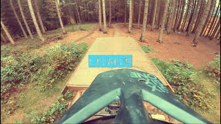
trail: Siegen Flowtrail
4:26 |
414 |
May 25, 2020 , Siegen
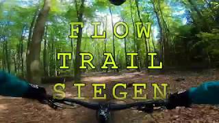
trail: Siegen Flowtrail
7:36 |
406 |
Jul 18, 2019 , Siegen
Recent Trail Reports
Activity Feed
| username | action | type | title | date |
|---|---|---|---|---|
| Hanghim | add | report | activity #96982475 and 1 more | Jun 14, 2026 @ 10:13am Jun 14, 2026 |
| trailforks | add | video | activity #96250738 | Jun 4, 2026 @ 2:00pm Jun 4, 2026 |
| Hanghim | add | report | activity #96216802 and 1 more | Jun 4, 2026 @ 4:29am Jun 4, 2026 |
| Muskelbiber | add | report | activity #96137609 and 2 more | Jun 2, 2026 @ 11:20pm Jun 2, 2026 |
| Hanghim | add | report | activity #94452092 and 1 more | May 10, 2026 @ 12:46pm May 10, 2026 |
Recent Comments
| username | type | title | comment | date |
|---|---|---|---|---|
| trail | Zumindest der Anfang ist zugewuchert und nicht... | Sep 22, 2025 @ 10:24pm Sep 22, 2025 | ||
| trail | Geil | Aug 24, 2025 @ 9:15am Aug 24, 2025 | ||
| trail | Geiler Name | Jun 20, 2025 @ 2:59am Jun 20, 2025 | ||
| trail | Sehr schöner Trail | Jun 18, 2025 @ 2:53pm Jun 18, 2025 | ||
| trail | Bitte nichtmehr befahren ist mit Förster... | Apr 28, 2025 @ 1:21am Apr 28, 2025 |
Local Badges
-

10 Black Trails0 awarded -

10 Blue Trails14 awarded -

10 Green Trails6 awarded -

Epic Mountain Bike Climb 2k4 awarded -

Climbing 10k Badge14 awarded -

Mountain Biking 100k Badge0 awarded
Bike & Skill Parks
| name | type | city | rating |
|---|---|---|---|
| Wilnsdorf motocross | skill park | Siegen |
Activity Type Stats
| activitytype | trails | distance | descent | descent distance | total vertical | rating | global rank | state rank | photos | reports | routes | ridelogs |
|---|---|---|---|---|---|---|---|---|---|---|---|---|
| Mountain Bike | 139 | 26 miles | 18,114 ft | 23 miles | 817 ft | #1,597 | #14 | 14 | 1,390 | 2,958 | ||
| E-Bike | 148 | 26 miles | 18,114 ft | 23 miles | 817 ft | #2,078 | #35 | 1,378 | 1,547 | |||
| Horse | 2 | 21 | ||||||||||
| Hike | 115 | 17 miles | 12,198 ft | 16 miles | 817 ft | #4,544 | #39 | 1,303 | 161 | |||
| Trail Running | 115 | 17 miles | 12,198 ft | 16 miles | 817 ft | #3,949 | #36 | 1,303 | 126 | |||
| Dirtbike/Moto | 1 | 12 |
Frequently Asked Questions About Siegen
▼
What are the highest rated mountain biking trails in Siegen?
The highest rated mountain biking trails in Siegen are:
- Corona Line (4.5/5)
- H...trail (Builders Edition) (4.4/5)
- Real Coward (4.4/5)
- Schwarzes Loch (2020 Edition) (4.4/5)
- Der Sender (4.4/5)
▼
Where can I park to ride in Siegen?
Check the Siegen trail map for trailhead and parking information. Community members regularly update access and parking details for trails in the area.
▼
What is the longest trail in Siegen?
The longest trail in Siegen is Siegen Flowtrail at 2.7 km. View all trails sorted by distance.
▼
How many trails are in Siegen?
Siegen has a total of 110 trails. Of those, 139 are designated for mountain biking. Browse top mountain biking trails in Siegen to find detailed information including difficulty ratings, distances, and trail conditions.
- By Sasse82
 TRAILFORKS & contributors
 - Admins: apply
- #56005 - 5,029 views
- siegen activity log | embed map of Siegen mountain bike trails |
Downloading of trail gps tracks in kml & gpx formats is enabled for Siegen.
You must login to download files.