close
-
Layers w
- Weather Layers
- Pro
- Pro
- Pro
- Pro
- Pro
- Pro
- More Layers
- Pro
- Pro
- Pro
- Pro
-
Upgrade to

3D
Trail Conditions
- Unknown
- Snow Groomed
- Snow Packed
- Snow Covered
- Snow Cover Partial
- Freeze/thaw Cycle
- Icy
- Prevalent Mud
- Wet
- Variable
- Ideal
- Dry
- Very Dry
Trail Flow (Ridden Direction)
Trailforks scans users ridelogs to determine the most popular direction each trail is ridden. A good flowing trail network will have most trails flowing in a single direction according to their intension.
The colour categories are based on what percentage of riders are riding a trail in its intended direction.
The colour categories are based on what percentage of riders are riding a trail in its intended direction.
- > 96%
- > 90%
- > 80%
- > 70%
- > 50%
- < 50%
- bi-directional trail
- no data
Trail Last Ridden
Trailforks scans ridelogs to determine the last time a trail was ridden.
- < 2 days
- < 1 week
- < 2 weeks
- < 1 month
- < 6 months
- > 6 months
Trail Ridden Direction
The intended direction a trail should be ridden.
- Downhill Only
- Downhill Primary
- Both Directions
- Uphill Primary
- Uphill Only
- One Direction
Contribute Details
Colors indicate trail is missing specified detail.
- Description
- Photos
- Description & Photos
- Videos
Trail Popularity ?
Trailforks scans ridelogs to determine which trails are ridden the most in the last 9 months.
Trails are compared with nearby trails in the same city region with a possible 25 colour shades.
Think of this as a heatmap, more rides = more kinetic energy = warmer colors.
- most popular
- popular
- less popular
- not popular
ATV/ORV/OHV Filter
Max Vehicle Width
inches
US Cell Coverage
Legend

Radar Time
Activity Recordings
Trailforks uses anonymized public activity data.
?
Activity Recordings
Trailforks uses anonymized public activity data.
?
Personal Heatmap
▶
Activity Types
all
/
none
▶
Options
2
Date range
month
–
Winter Trails
Warning
A routing network for winter maps does not exist. Selecting trails using the winter trails layer has been disabled.
Missing Trails
Most Popular
Least Popular
Trails are colored based on popularity. The more popular a trail is, the more red. Less popular trails trend towards green.
Jump Magnitude Heatmap
Heatmap of where riders jump on trails. Zoom in to see individual jumps, click circles to view jump details.
BC Backroad Status
![map legend]()
Service Road Atlas is a free to use, community-driven service for viewing and creating reports on the numerous back-country service roads around B.C. and Alberta.

Slope Aspect
Direction the slope faces
Trails Deemphasized
Trails are shown in grey.
Only show trails with no bike usage.
Suggested Layers
Based on selected activity type
Save the current map location and zoom level as your default home location whenever this page is loaded.
SaveTrail construction in Silvan Forest started in Nov 2014, and the 170 hectares of private forest has quickly become one of Nelson's favourite riding areas, with 24 hour, free public access.
A core network of fun, safe trails, with well graded single track climbing trails forming a backbone from the bottom of the property to the top ridge. Plenty of long run downhill options to ride, all with their own character.
2018 saw the pine forest harvested, with trail rebuilding happening in tandem with harvest ops - the core network of trails is back in place and improved as of Sept 2019.
Future trail development will move into the grade 4/5 area and linkage trails to the adjacent Kingsland Forest.
Trails in Silvan Forest are graded against the New Zealand Mountainbike Trail Design and Construction Guidelines (2023)
source: Silvan Forest
Primary Trail Type: All-Mountain & Downhill
eBikes Allowed:
Yes
Land Status: Private Managed Forest
Land Manager: Silvan Forest
 google parking directions
 Access Info:
Trailhead opposite #205 Champion Road, Richmond
Links
Activities Click to view
- Mountain Bike
53 trails
- E-Bike
33 trails
- Hike
38 trails
- Trail Running
39 trails
Region Details
- 8
- 7
- 22
- 6
- 4
- 1
Region Status
Open as of May 28, 2026Local Trail Association
Stats
- Avg Trail Rating
- Trails (view details)
- 53
- Trails Mountain Bike
- 55
- Trails E-Bike
- 33
- Trails Hike
- 38
- Trails Trail Running
- 39
- Total Distance
- 22 miles
- Total Descent
- 8,498 ft
- Total Vertical
- 1,746 ft
- Highest Trailhead
- 1,805 ft
- Reports
- 932
- Photos
- 75
- Ridden Counter
- 16,278
Popular Silvan Forest Mountain Biking Trails
• 95 ★ 3.9 • 1 mile • 700 ft • 713 •
Popular blue difficulty singletrack. This mountain bike primary trail can be used uphill primary and has a moderate overall physical rating with a 700 ft green climb. On average it takes 14 minutes to complete this trail.
• 95 ★ 3.8 • 2 miles • 844 ft • 670 •
Popular blue difficulty singletrack. This mountain bike primary trail can be used both directions and has a moderate overall physical rating with a 844 ft green climb. Trail visibility is always easy to follow. On average it takes 21 minutes to complete this trail.
• 90 ★ 4.3 • 2,792 ft • 44 ft • 632 •
Quick flowing single track trail used to exit the park or return to the bottom for another climb.
• 90 ★ 3.7 • 3,688 ft • 445 ft • 581 •
Top section of the climbing track. Finish is at the skyline/highest point of the park.
• 75 ★ 4.8 • 2,559 ft • 88 ft • 539 •
Short and fast down track with nicely bermed corners. Good for beginners as isn't technical.
• 80 ★ 2.5 • 259 ft • 8 ft • 529 •
Popular blue difficulty singletrack. This mountain bike primary trail can be used uphill primary and has a moderate overall physical rating with a 8 ft green climb. On average it takes minutes to complete this trail.
• 50 ★ 2.5 • 1 mile • 448 ft • 512 •
Long, traversing trail from the main trail network just above the amphitheatre, across to the Kingsland gate on Oliver Rd (bottom of ). cuts in and out of some stunning native bush gullies on its way across the face of Silvan.
Photos of Silvan Forest Mountain Bike
Videos of Silvan Forest Mountain Bike
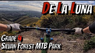
trail: de la Luna
8:08 |
386 |
Aug 24, 2024 , Nelson
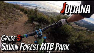
trail: de la Luna
4:07 |
247 |
Jun 16, 2024 , Nelson
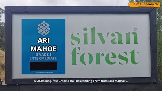
trail: Ari Mahoe
3:14 |
219 |
Feb 11, 2024 , Nelson
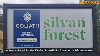
trail: Goliath
2:56 |
196 |
Feb 10, 2024 , Nelson
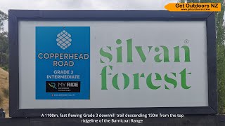
trail: Copperhead Road
3:00 |
283 |
Jan 30, 2024 , Nelson

trail: Ezra Mamaku
2:47 |
207 |
Jan 30, 2024 , Nelson

trail: Exodus
4:46 |
183 |
Jan 30, 2024 , Nelson
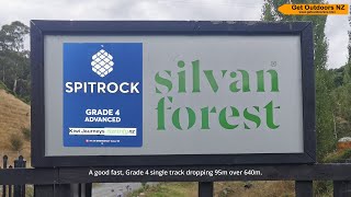
trail: Spittrock
2:20 |
239 |
Jan 26, 2024 , Nelson
Recent Trail Reports
| status | trail | date | condition | info | user |
|---|---|---|---|---|---|
| de la Luna | May 29, 2026 @ 5:23pm (Pacific/Auckland) May 28, 2026 | Dry | autopilot84 | ||
| Jericho | May 10, 2026 @ 9:27am (Pacific/Auckland) May 9, 2026 | Unknown | Rolyinnz WGTV | ||
| Jericho | Mar 17, 2026 @ 8:00am (Pacific/Auckland) Mar 16, 2026 | Dry | Mildie MTBTT | ||
| SH 6 Underpass | Mar 16, 2026 @ 10:39am (Pacific/Auckland) Mar 15, 2026 | Ideal | AIntemann | ||
| Alpha Rima | Feb 12, 2026 @ 2:48pm (Pacific/Auckland) Feb 11, 2026 | Ideal | rulbike | ||
| Omega | Feb 10, 2026 @ 2:01pm (Pacific/Auckland) Feb 9, 2026 | Dry | rulbike | ||
| Hare Down | Feb 10, 2026 @ 2:01pm (Pacific/Auckland) Feb 9, 2026 | Dry | rulbike | ||
| Kircam Alley | Feb 10, 2026 @ 2:00pm (Pacific/Auckland) Feb 9, 2026 | Dry | rulbike | ||
| Ezra Mamaku | Feb 10, 2026 @ 2:00pm (Pacific/Auckland) Feb 9, 2026 | Dry | rulbike | ||
| Alpha Wha | Feb 10, 2026 @ 1:59pm (Pacific/Auckland) Feb 9, 2026 | Ideal | rulbike |
Activity Feed
| username | action | type | title | date |
|---|---|---|---|---|
| Rosjier3sz1dh | difficultyvote | trail | activity #97291028 | Jun 18, 2026 @ 7:17pm 2 days |
| OllieMTBSILVANMCGAZZA | add | photo | activity #97131011 | Jun 16, 2026 @ 12:26pm Jun 16, 2026 |
| autopilot84 | add | report | activity #95757441 | May 28, 2026 @ 10:23pm May 28, 2026 |
| aceukC8Ti | vote | trail | activity #95380761 and 10 more | May 23, 2026 @ 11:22pm May 23, 2026 |
| aceukC8Ti | ridden | trail | activity #95380760 and 10 more | May 23, 2026 @ 11:22pm May 23, 2026 |
Recent Comments
| username | type | title | comment | date |
|---|---|---|---|---|
| report | sorted on May 10th Karolyne | May 11, 2026 @ 12:59pm May 11, 2026 | ||
| trail | A nice and short trail. Has one or two drops... | Mar 31, 2026 @ 3:59pm Mar 31, 2026 | ||
| trail | A one of the more challenging grade fours.... | Mar 31, 2026 @ 3:53pm Mar 31, 2026 | ||
| trail | Really nice cool quick trail, a little bit... | Mar 31, 2026 @ 3:48pm Mar 31, 2026 | ||
| trail | Enjoyed this track today in very dry... | Mar 24, 2026 @ 9:35pm Mar 24, 2026 |
Nearby Areas
| name | distance | ||||
|---|---|---|---|---|---|
| Richmond Hills | 5 | 1.1 km | |||
| Marsden Valley | 4 | 6 | 2.8 km | ||
| Aniseed Valley | 3 | 4.5 km | |||
| The Grampians | 1 | 3 | 5.3 km | ||
| Codgers | 4 | 6.4 km |
Local Badges
-

Completionist45 awarded
Local Trail Supporters
- http://www.mtbtrailstrust.org.nz/
Activity Type Stats
| activitytype | trails | distance | descent | descent distance | total vertical | rating | global rank | state rank | photos | reports | routes | ridelogs |
|---|---|---|---|---|---|---|---|---|---|---|---|---|
| Mountain Bike | 53 | 20 miles | 8,432 ft | 12 miles | 1,745 ft | #961 | #36 | 72 | 935 | 9,996 | ||
| E-Bike | 33 | 10 miles | 3,182 ft | 6 miles | 1,739 ft | #2,124 | #56 | 777 | 1,726 | |||
| Hike | 38 | 17 miles | 4,521 ft | 8 miles | 1,739 ft | #3,989 | #71 | 2 | 874 | 81 | ||
| Trail Running | 39 | 18 miles | 4,836 ft | 9 miles | 1,745 ft | #3,035 | #53 | 1 | 880 | 525 |
Frequently Asked Questions About Silvan Forest
▼
What are the highest rated mountain biking trails in Silvan Forest?
The highest rated mountain biking trails in Silvan Forest are:
- Hare Down (4.4/5)
- Ari Mahoe (4.3/5)
- Ezra Mamaku (4.3/5)
- de la Luna (4.2/5)
- Omega (4.2/5)
▼
What is the best time of the year to ride in Silvan Forest?
Based on ride log data, the most popular months to ride in Silvan Forest are:
- July (65 activities)
- January (55 activities)
- March (53 activities)
▼
Where can I park to ride in Silvan Forest?
There are 1 parking locations listed in Silvan Forest. The most popular parking spots are:
▼
What is the longest trail in Silvan Forest?
The longest trail in Silvan Forest is Alpha at 2.8 km. View all trails sorted by distance.
Activities
- By Mildie MTBTT & contributors
- Admins: Aorere-Enduro, NelsonCouncil, MTBTT
- #10513 - 27,319 views
- silvan forest activity log | embed map of Silvan Forest mountain bike trails | silvan forest mountain biking points of interest
Downloading of trail gps tracks in kml & gpx formats is enabled for Silvan Forest.
You must login to download files.