close
-
Layers w
- Weather Layers
- Pro
- Pro
- Pro
- Pro
- Pro
- Pro
- More Layers
- Pro
- Pro
- Pro
- Pro
-
Upgrade to

3D
Trail Conditions
- Unknown
- Snow Groomed
- Snow Packed
- Snow Covered
- Snow Cover Partial
- Freeze/thaw Cycle
- Icy
- Prevalent Mud
- Wet
- Variable
- Ideal
- Dry
- Very Dry
Trail Flow (Ridden Direction)
Trailforks scans users ridelogs to determine the most popular direction each trail is ridden. A good flowing trail network will have most trails flowing in a single direction according to their intension.
The colour categories are based on what percentage of riders are riding a trail in its intended direction.
The colour categories are based on what percentage of riders are riding a trail in its intended direction.
- > 96%
- > 90%
- > 80%
- > 70%
- > 50%
- < 50%
- bi-directional trail
- no data
Trail Last Ridden
Trailforks scans ridelogs to determine the last time a trail was ridden.
- < 2 days
- < 1 week
- < 2 weeks
- < 1 month
- < 6 months
- > 6 months
Trail Ridden Direction
The intended direction a trail should be ridden.
- Downhill Only
- Downhill Primary
- Both Directions
- Uphill Primary
- Uphill Only
- One Direction
Contribute Details
Colors indicate trail is missing specified detail.
- Description
- Photos
- Description & Photos
- Videos
Trail Popularity ?
Trailforks scans ridelogs to determine which trails are ridden the most in the last 9 months.
Trails are compared with nearby trails in the same city region with a possible 25 colour shades.
Think of this as a heatmap, more rides = more kinetic energy = warmer colors.
- most popular
- popular
- less popular
- not popular
ATV/ORV/OHV Filter
Max Vehicle Width
inches
US Cell Coverage
Legend

Radar Time
Activity Recordings
Trailforks uses anonymized public activity data.
?
Activity Recordings
Trailforks uses anonymized public activity data.
?
Personal Heatmap
▶
Activity Types
all
/
none
▶
Options
2
Date range
month
–
Winter Trails
Warning
A routing network for winter maps does not exist. Selecting trails using the winter trails layer has been disabled.
Missing Trails
Most Popular
Least Popular
Trails are colored based on popularity. The more popular a trail is, the more red. Less popular trails trend towards green.
Jump Magnitude Heatmap
Heatmap of where riders jump on trails. Zoom in to see individual jumps, click circles to view jump details.
BC Backroad Status
![map legend]()
Service Road Atlas is a free to use, community-driven service for viewing and creating reports on the numerous back-country service roads around B.C. and Alberta.

Slope Aspect
Direction the slope faces
Trails Deemphasized
Trails are shown in grey.
Only show trails with no bike usage.
Suggested Layers
Based on selected activity type
Save the current map location and zoom level as your default home location whenever this page is loaded.
Save
No description for Silver City has been added yet!
Login or register to submit one.
Activities Click to view
- Mountain Bike
110 trails
- E-Bike
10 trails
- Gravel Bike
0 trails
- Adaptive Bike
0 trails
- Horse
131 trails
- Hike
237 trails
- Trail Running
231 trails
- Dirtbike/Moto
4 trails
Region Details
- 16
- 2
- 40
- 42
- 10
Region Status
Caution as of Jun 3, 2026Stats
- Avg Trail Rating
- Trails (view details)
- 205
- Trails Mountain Bike
- 110
- Trails E-Bike
- 10
- Trails Horse
- 131
- Trails Hike
- 237
- Trails Trail Running
- 231
- Trails Dirtbike/Moto
- 4
- Trails ATV/ORV/OHV
- 3
- Total Distance
- 704 miles
- Total Descent
- 95,811 ft
- Total Vertical
- 5,652 ft
- Highest Trailhead
- 10,747 ft
- Reports
- 560
- Photos
- 474
- Ridden Counter
- 3,842
Articles

What I've Learned from Hiking America's First Wilderness Area
Jul 17, 2024 from backpacker.com
As the Gila Wilderness, the nation's first protected wilderness area, celebrates its centennial, a backpacker reflects on decades hiking it.
Sub Regions
-
Boston Hill
- 12
- 16
-
Burro Mountains
-
City of Rocks State Park
- 3
- 2
-
Fort Bayard
- 1
- 14
- 5
- 2
-
Gila Wilderness
- 1
- 5
- 3
-
Gomez Peak Area
-
Little Walnut
- 1
- 7
- 7
- 3
Popular Silver City Mountain Biking Trails
• 100 ★ 0.0 • 4,863 ft • 31 ft • 192 •
Popular blue difficulty singletrack. This mountain bike primary trail can be used both directions. On average it takes 4 minutes to complete this trail.
• 100 ★ 3.0 • 2 miles • 105 ft • 174 •
Popular green difficulty singletrack. This mountain bike primary trail can be used downhill primary. On average it takes 6 minutes to complete this trail.
• 90 ★ 4.0 • 1 mile • 18 ft • 143 •
Popular green difficulty singletrack. This mountain bike primary trail. On average it takes 8 minutes to complete this trail.
• 100 ★ 0.0 • 2 miles • 214 ft • 100 •
Popular green difficulty singletrack. This mountain bike primary trail can be used uphill primary. On average it takes 13 minutes to complete this trail.
• 95 ★ 4.0 • 2 miles • 296 ft • 93 •
Popular green difficulty singletrack. This mountain bike primary trail can be used both directions and has a moderate overall physical rating with a 296 ft green climb. On average it takes 13 minutes to complete this trail.
• 95 ★ 4.0 • 2 miles • 85 ft • 86 •
Popular green difficulty mixed. This mountain bike primary trail can be used downhill primary and has a easy overall physical rating with a 85 ft green climb. On average it takes 8 minutes to complete this trail.
• 90 ★ 3.7 • 4,810 ft • 93 ft • 85 •
Popular green difficulty singletrack. This mountain bike primary trail can be used both directions. On average it takes 8 minutes to complete this trail.
• 90 ★ 0.0 • 1 mile • 147 ft • 78 •
Popular green difficulty singletrack. This mountain bike primary trail can be used both directions. On average it takes 10 minutes to complete this trail.
Silver City Mountain Bike Routes
12 miles • 1,220 ft • 2 • Loop •
The /CDT loop is a 12-mile scenic and rugged circuit in the Saddle Rock area of the Big Burro Mountains....
4 miles • 1,471 ft • 0 • Out & Back •
This trail travels up about 1500 ft to wonderful views of the east and west. It travels through pinion...
23 miles • 3,604 ft • 0 • Loop •
This loop is close to Silver City and Mimbres but feels more remote. A seemingly dry area that has fairly...
★ 5.0 • 13 miles • 934 ft • 4 • Loop • Race •
Race course for the 2025 Tommyknocker 10 event
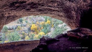
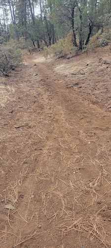
Photos of Silver City Mountain Bike
Videos of Silver City Mountain Bike
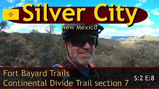
trail: CDT - Silver City (Sec 7)
15:43 |
730 |
Feb 7, 2021 , Silver City

trail: Dragonfly Loop #720
15:43 |
356 |
Feb 7, 2021 , Silver City
11:35 |
273 |
Jan 3, 2022 , Silver City
Recent Trail Reports
| status | trail | date | condition | info | user |
|---|---|---|---|---|---|
| Dragonfly Loop #720 | Apr 27, 2026 @ 3:58pm (America/Denver) Apr 27, 2026 | Very Dry | DaveFazzone | ||
| Dragonfly Loop #720 | Apr 27, 2026 @ 3:58pm (America/Denver) Apr 27, 2026 | Dry | DaveFazzone | ||
| Scenic Trail | Mar 17, 2026 @ 11:08am (America/Denver) Mar 17, 2026 | Unknown | GilaTrails GILABCH | ||
| Sycamore Canyon | Dec 29, 2025 @ 8:23am (America/Denver) Dec 29, 2025 | Unknown | GilaTrails GILABCH | ||
| Mountain Loop | Oct 3, 2025 @ 7:59am (America/Ciudad_Juarez) Oct 3, 2025 | Dry | jheynekamp STA | ||
| Dragon Trail | Oct 3, 2025 @ 7:59am (America/Ciudad_Juarez) Oct 3, 2025 | Dry | jheynekamp STA | ||
| CDT - Black Peak (NM Sec 8) | Sep 21, 2025 @ 9:57pm (America/Denver) Sep 21, 2025 | Dry | markegge | ||
| South Fork Mineral Creek | Sep 16, 2025 @ 9:32am (America/Denver) Sep 16, 2025 | Unknown | GilaTrails GILABCH | ||
| Woodhaul Wagon Road Trail | Aug 16, 2025 @ 4:23pm Aug 16, 2025 | Ideal | Singletrackz | ||
| Sawmill Wagon Road Trail | Aug 16, 2025 @ 4:23pm Aug 16, 2025 | Ideal | Singletrackz |
National Scenic Trails & Official Routes
-
Continental Divide Trail
- Mountain Bike
- Hike
- Trail Running
-
Continental Divide Trail (Bike)
- Mountain Bike

Activity Feed
| username | action | type | title | date |
|---|---|---|---|---|
| alibecker | wishlist | region | activity #96546137 | Jun 8, 2026 @ 9:44am Jun 8, 2026 |
| JeffreyNijfhr | wishlist | region | activity #95777210 | May 29, 2026 @ 7:53am May 29, 2026 |
| cowboycorbin | add | photo | activity #95437809 | May 24, 2026 @ 12:49pm May 24, 2026 |
| SGordon418 | ridden | trail | activity #95126317 | May 20, 2026 @ 12:22pm May 20, 2026 |
| 7DucIJ | ridden | trail | activity #94783799 | May 15, 2026 @ 6:39pm May 15, 2026 |
Recent Comments
| username | type | title | comment | date |
|---|---|---|---|---|
| trail | Agreed lots of trees down as of 2024 winter | Jun 27, 2025 @ 11:55am Jun 27, 2025 | ||
| trail | Super rocky pretty fun definitely a little... | Jun 27, 2025 @ 11:18am Jun 27, 2025 | ||
| trail | This is a bomb descent. Chunky descent along... | Jun 10, 2025 @ 7:16am Jun 10, 2025 | ||
| trail | Did an out and back from the CDT connector.... | Jun 9, 2025 @ 4:19pm Jun 9, 2025 | ||
| trail | Agree: fun, flowy, downhill, but don't look... | May 22, 2025 @ 3:15pm May 22, 2025 |
Local Badges
-

10 Green Trails41 awarded -

10 Blue Trails15 awarded -

Epic Ride Climb 2k69 awarded -

Climbing 10k Badge11 awarded -

Climbing 100k Badge1 awarded -

Epic Ride Descent 2k65 awarded
Local Mountain Biking Directory
-
Silver City Cycles
-
Gila Hike & BikeBike Shop
-
Spoke N' Word CyclesBike Shop
Activity Type Stats
| activitytype | trails | distance | descent | descent distance | total vertical | rating | global rank | state rank | photos | reports | routes | ridelogs |
|---|---|---|---|---|---|---|---|---|---|---|---|---|
| Mountain Bike | 110 | 251 miles | 32,598 ft | 112 miles | 3,793 ft | #1,011 | #397 | 58 | 208 | 5 | 4,243 | |
| E-Bike | 10 | 63 miles | 7,657 ft | 32 miles | 2,956 ft | #2,989 | #1,112 | 6 | 149 | 33 | ||
| Horse | 131 | 567 miles | 78,179 ft | 246 miles | 5,653 ft | #10 | #307 | 138 | 419 | 18 | ||
| Hike | 237 | 704 miles | 95,810 ft | 301 miles | 5,653 ft | #105 | #60 | 255 | 551 | 23 | 1,162 | |
| Trail Running | 231 | 703 miles | 95,518 ft | 300 miles | 5,653 ft | #100 | #48 | 553 | 20 | 111 | ||
| Dirtbike/Moto | 4 | 55 miles | 6,690 ft | 28 miles | 2,283 ft | #693 | #240 | 47 | 3 | |||
| ATV/ORV/OHV | 3 | 53 miles | 5,502 ft | 27 miles | 1,765 ft | 47 |
Frequently Asked Questions About Silver City
▼
What are the best places to ride in Silver City?
Silver City has 8 areas to explore for mountain biking. The top rated areas are:
▼
What are the highest rated mountain biking trails in Silver City?
The highest rated mountain biking trails in Silver City are:
- Signal Peak (4.1/5)
- Servis Corrals (4/5)
- Little Cherry (4/5)
- The Watering Hole (4/5)
- Cornell Ranch #758 (4/5)
▼
What is the best time of the year to ride in Silver City?
Based on ride log data, the most popular months to ride in Silver City are:
- April (20 activities)
- September (16 activities)
- November (14 activities)
▼
Where can I park to ride in Silver City?
There are 45 parking locations listed in Silver City. The most popular parking spots are:
- Dragon Fly Trailhead Parking
- Gomez Peak
- North Walnut Creek Parking
- Little Walnut Picnic Area
- Signal Peak & Tadpole Ridge Trailhead
Activities
Trails
Points of Interest
- Rocky Canyon Campground Camping
- Alum Camp Other
- Whiterock volcanic tuff formation Other
- Sapillo Group Area Campground Camping
- Lilley Park Other
- White Creek Flats Camping
- Woody's Corral Dispersed Camping area
- Ben Lilly Campground Camping
- Nabours Mountain Summit
- Yellow Mountain Summit (2,461m)
- McKnight Mountain (10,157 ft)
- Hillsboro Peak (10,016 ft)
- Reeds Peak (9,993 ft)
- By todd
 Trailforks & contributors
 - Admins: GILABCH
- #17725 - 10,097 views
- silver city activity log | embed map of Silver City mountain bike trails | silver city mountain biking points of interest
Downloading of trail gps tracks in kml & gpx formats is enabled for Silver City.
You must login to download files.