close
-
Layers w
- Weather Layers
- Pro
- Pro
- Pro
- Pro
- Pro
- Pro
- More Layers
- Pro
- Pro
- Pro
- Pro
-
Upgrade to

3D
Trail Conditions
- Unknown
- Snow Groomed
- Snow Packed
- Snow Covered
- Snow Cover Partial
- Freeze/thaw Cycle
- Icy
- Prevalent Mud
- Wet
- Variable
- Ideal
- Dry
- Very Dry
Trail Flow (Ridden Direction)
Trailforks scans users ridelogs to determine the most popular direction each trail is ridden. A good flowing trail network will have most trails flowing in a single direction according to their intension.
The colour categories are based on what percentage of riders are riding a trail in its intended direction.
The colour categories are based on what percentage of riders are riding a trail in its intended direction.
- > 96%
- > 90%
- > 80%
- > 70%
- > 50%
- < 50%
- bi-directional trail
- no data
Trail Last Ridden
Trailforks scans ridelogs to determine the last time a trail was ridden.
- < 2 days
- < 1 week
- < 2 weeks
- < 1 month
- < 6 months
- > 6 months
Trail Ridden Direction
The intended direction a trail should be ridden.
- Downhill Only
- Downhill Primary
- Both Directions
- Uphill Primary
- Uphill Only
- One Direction
Contribute Details
Colors indicate trail is missing specified detail.
- Description
- Photos
- Description & Photos
- Videos
Trail Popularity ?
Trailforks scans ridelogs to determine which trails are ridden the most in the last 9 months.
Trails are compared with nearby trails in the same city region with a possible 25 colour shades.
Think of this as a heatmap, more rides = more kinetic energy = warmer colors.
- most popular
- popular
- less popular
- not popular
ATV/ORV/OHV Filter
Max Vehicle Width
inches
US Cell Coverage
Legend

Radar Time
Activity Recordings
Trailforks uses anonymized public activity data.
?
Activity Recordings
Trailforks uses anonymized public activity data.
?
Personal Heatmap
▶
Activity Types
all
/
none
▶
Options
2
Date range
month
–
Winter Trails
Warning
A routing network for winter maps does not exist. Selecting trails using the winter trails layer has been disabled.
Missing Trails
Most Popular
Least Popular
Trails are colored based on popularity. The more popular a trail is, the more red. Less popular trails trend towards green.
Jump Magnitude Heatmap
Heatmap of where riders jump on trails. Zoom in to see individual jumps, click circles to view jump details.
BC Backroad Status
![map legend]()
Service Road Atlas is a free to use, community-driven service for viewing and creating reports on the numerous back-country service roads around B.C. and Alberta.

Slope Aspect
Direction the slope faces
Trails Deemphasized
Trails are shown in grey.
Only show trails with no bike usage.
Suggested Layers
Based on selected activity type
Save the current map location and zoom level as your default home location whenever this page is loaded.
Save
No description for Sioux City has been added yet!
Login or register to submit one.
Activities Click to view
- Mountain Bike
53 trails
- E-Bike
27 trails
- Adaptive Bike
0 trails
- Winter Fat Bike
1 trails
- Horse
5 trails
- Hike
33 trails
- Trail Running
34 trails
- Snowmobile
6 trails
Region Details
- 5
- 1
- 15
- 27
- 5
Region Status
Caution as of Jun 13, 2026Stats
- Avg Trail Rating
- Trails (view details)
- 53
- Trails Mountain Bike
- 55
- Trails E-Bike
- 27
- Trails Winter Fat Bike
- 1
- Trails Horse
- 5
- Trails Hike
- 33
- Trails Trail Running
- 34
- Trails Snowmobile
- 6
- Total Distance
- 12 miles
- Total Descent Distance
- 5 miles
- Total Descent
- 999 ft
- Total Vertical
- 296 ft
- Highest Trailhead
- 1,405 ft
- Reports
- 300
- Photos
- 269
- Ridden Counter
- 3,431
Sub Regions
-
Bacon Creek Park
- 1
-
Cone Park
- 1
- 14
- 19
- 5
-
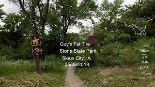
Stone State Park
- 1
- 7
Popular Sioux City Mountain Biking Trails
• 95 ★ 3.0 • 427 ft • 0 ft • 106 •
Introduction to rock features and raised wooden features.
• 100 ★ 4.0 • 627 ft • 0 ft • 105 •
Hard surfaced jump line with wooden lips. Each jump has a ride around option.
• 95 ★ 0.0 • 472 ft • 0 ft • 101 •
A man-made chunky descent line. Some large rocks here, be sure to take a look at it before riding.
• 80 ★ 4.0 • 2,133 ft • 0 ft • 94 •
Machine built jump line. Great mix of rollers, table tops and doubles. Fun to session for a wide range of jump skill sets.
• 80 ★ 4.0 • 1,512 ft • 0 ft • 93 •
Jump line with a mix of steeper lip jumps and tight berms that require more skill and practice to master. Crosses another trail. Please watch for other riders.
• 95 ★ 4.0 • 771 ft • 3 ft • 91 •
for bikes to top of hub "F". Also to tops of Cilo's Side and Scheel's Steeze.
• 100 ★ 4.0 • 686 ft • 0 ft • 91 •
Advanced slopestyle jump line with gap jumps, whale-tail, and wooden 180 degree wall ride. Hard surfaced so can be ridden as soon as the wood is dry. Caution: Wood can be slippery when wet.
• 100 ★ 0.0 • 791 ft • 0 ft • 91 •
Outstanding Velosolutions asphalt pump track. Counter clockwise is primary direction.
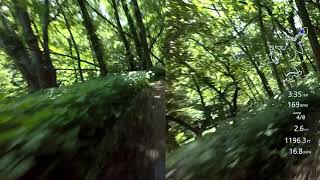
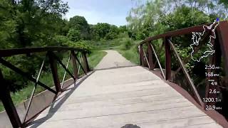
Videos of Sioux City Mountain Bike
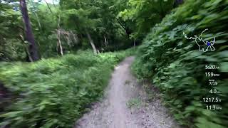
trail: Mount Lucia Trail
0:54 |
284 |
Oct 4, 2020 , Sioux City

trail: Longfoot Trail
0:54 |
266 |
Oct 4, 2020 , Sioux City

trail: Loess Trail
0:54 |
184 |
Oct 4, 2020 , Sioux City
trail: Broken Toe Trail
43:39 |
621 |
Oct 4, 2020 , Sioux City

trail: Mark's Glen Trail
43:39 |
315 |
Oct 4, 2020 , Sioux City
trail: Bacon Creek Trail
2:30 |
616 |
Oct 4, 2020 , Sioux City
trail: Bacon Creek Trail
40:55 |
957 |
Oct 4, 2020 , Sioux City
Recent Trail Reports
| status | trail | date | condition | info | user |
|---|---|---|---|---|---|
| Lane's Lane | Jun 13, 2026 @ 4:13pm (America/Chicago) Jun 13, 2026 | Dry | fryguy63 THOR | ||
| Chutes & Ladders | Jun 13, 2026 @ 3:52pm (America/Chicago) Jun 13, 2026 | Dry | fryguy63 THOR | ||
| Praire Lane | Jun 13, 2026 @ 3:51pm (America/Chicago) Jun 13, 2026 | Dry | fryguy63 THOR | ||
| Kinetic Energy | May 21, 2026 @ 1:29pm (America/Chicago) May 21, 2026 | Unknown | birdbstr | ||
| Mechanical Failure | May 16, 2026 @ 10:16am (America/Chicago) May 16, 2026 | Dry | MisterMolls | ||
| Cilo's Slide | May 16, 2026 @ 10:15am (America/Chicago) May 16, 2026 | Dry | MisterMolls | ||
| Harvest Trail | May 16, 2026 @ 10:15am (America/Chicago) May 16, 2026 | Dry | MisterMolls | ||
| The Flying Irishman | May 16, 2026 @ 10:15am (America/Chicago) May 16, 2026 | Dry | MisterMolls | ||
| Well Well Well | May 16, 2026 @ 10:12am (America/Chicago) May 16, 2026 | Dry | MisterMolls | ||
| Palmershiem's Pass | May 16, 2026 @ 10:12am (America/Chicago) May 16, 2026 | Dry | MisterMolls |
Activity Feed
| username | action | type | title | date |
|---|---|---|---|---|
| DGavlick | wishlist | region | activity #97518825 | Jun 21, 2026 @ 2:02pm 2 days |
| fryguy63 | add | report | activity #96913518 and 2 more | Jun 13, 2026 @ 1:51pm Jun 13, 2026 |
| fryguy63 | update | trail | activity #96910372 and 2 more | Jun 13, 2026 @ 1:16pm Jun 13, 2026 |
| birdbstr | add | report | activity #95189995 | May 21, 2026 @ 11:29am May 21, 2026 |
| Oneathefaintest | ridden | trail | activity #95130102 and 1 more | May 20, 2026 @ 1:29pm May 20, 2026 |
Recent Comments
| username | type | title | comment | date |
|---|---|---|---|---|
| report | Transition to first wood ramp, and wall ride... | Sep 4, 2025 @ 8:19pm Sep 4, 2025 | ||
| trail | Gmhg | Jul 14, 2025 @ 8:24am Jul 14, 2025 | ||
| trail | Bob | Jul 14, 2025 @ 8:24am Jul 14, 2025 | ||
| trail | Thistles are going to seed. | Jul 6, 2025 @ 3:54pm Jul 6, 2025 | ||
| trail | Park Maintenance cutting grass/weeds between... | Jun 23, 2025 @ 6:24pm Jun 23, 2025 |
Local Badges
-

Completionist1 awarded -

10 Blue Trails11 awarded -

10 Green Trails11 awarded -

Epic Mountain Bike Climb 2k0 awarded -

Climbing 10k Badge0 awarded -

Mountain Biking 100k Badge0 awarded
Activity Type Stats
| activitytype | trails | distance | descent | descent distance | total vertical | rating | global rank | state rank | photos | reports | routes | ridelogs |
|---|---|---|---|---|---|---|---|---|---|---|---|---|
| Mountain Bike | 53 | 12 miles | 997 ft | 5 miles | 295 ft | #4,073 | #1,370 | 251 | 285 | 1,090 | ||
| E-Bike | 27 | #7,744 | #2,336 | 238 | 304 | |||||||
| Winter Fat Bike | 1 | #409 | #1,181 | 9 | ||||||||
| Horse | 5 | 3 miles | 361 ft | 5,059 ft | 295 ft | #3,219 | #1,838 | 6 | ||||
| Hike | 33 | 12 miles | 997 ft | 5 miles | 295 ft | #3,862 | #1,367 | 19 | 97 | 255 | ||
| Trail Running | 34 | 12 miles | 997 ft | 5 miles | 295 ft | #8,667 | #2,898 | 100 | 74 | |||
| Snowmobile | 6 | 5 miles | 335 ft | 1 mile | 272 ft | #391 | #207 |
Frequently Asked Questions About Sioux City
▼
What are the best places to ride in Sioux City?
Sioux City has 3 areas to explore for mountain biking. The top rated areas are:
▼
What are the highest rated mountain biking trails in Sioux City?
The highest rated mountain biking trails in Sioux City are:
- Bacon Creek Trail (4.2/5)
- Mount Lucia Trail (4.1/5)
- Mark's Glen Trail (4.1/5)
- Cowboy's Coffee (4/5)
- Big Sioux Trail (4/5)
▼
What is the best time of the year to ride in Sioux City?
Based on ride log data, the most popular months to ride in Sioux City are:
- July (9 activities)
- August (6 activities)
- September (2 activities)
▼
Where can I park to ride in Sioux City?
There are 10 parking locations listed in Sioux City. The most popular parking spots are: View all parking and trailhead locations on the map to plan your visit.
Activities
Trails
- By Agirlcyclist & contributors
- Admins: THOR
- #41065 - 4,451 views
- sioux city activity log | embed map of Sioux City mountain bike trails | sioux city mountain biking points of interest
Downloading of trail gps tracks in kml & gpx formats is enabled for Sioux City.
You must login to download files.