close
-
Layers w
- Weather Layers
- Pro
- Pro
- Pro
- Pro
- Pro
- Pro
- More Layers
- Pro
- Pro
- Pro
- Pro
-
Upgrade to

3D
Trail Conditions
- Unknown
- Snow Groomed
- Snow Packed
- Snow Covered
- Snow Cover Partial
- Freeze/thaw Cycle
- Icy
- Prevalent Mud
- Wet
- Variable
- Ideal
- Dry
- Very Dry
Trail Flow (Ridden Direction)
Trailforks scans users ridelogs to determine the most popular direction each trail is ridden. A good flowing trail network will have most trails flowing in a single direction according to their intension.
The colour categories are based on what percentage of riders are riding a trail in its intended direction.
The colour categories are based on what percentage of riders are riding a trail in its intended direction.
- > 96%
- > 90%
- > 80%
- > 70%
- > 50%
- < 50%
- bi-directional trail
- no data
Trail Last Ridden
Trailforks scans ridelogs to determine the last time a trail was ridden.
- < 2 days
- < 1 week
- < 2 weeks
- < 1 month
- < 6 months
- > 6 months
Trail Ridden Direction
The intended direction a trail should be ridden.
- Downhill Only
- Downhill Primary
- Both Directions
- Uphill Primary
- Uphill Only
- One Direction
Contribute Details
Colors indicate trail is missing specified detail.
- Description
- Photos
- Description & Photos
- Videos
Trail Popularity ?
Trailforks scans ridelogs to determine which trails are ridden the most in the last 9 months.
Trails are compared with nearby trails in the same city region with a possible 25 colour shades.
Think of this as a heatmap, more rides = more kinetic energy = warmer colors.
- most popular
- popular
- less popular
- not popular
ATV/ORV/OHV Filter
Max Vehicle Width
inches
US Cell Coverage
Legend

Radar Time
Activity Recordings
Trailforks uses anonymized public activity data.
?
Activity Recordings
Trailforks uses anonymized public activity data.
?
Personal Heatmap
▶
Activity Types
all
/
none
▶
Options
2
Date range
month
–
Winter Trails
Warning
A routing network for winter maps does not exist. Selecting trails using the winter trails layer has been disabled.
Missing Trails
Most Popular
Least Popular
Trails are colored based on popularity. The more popular a trail is, the more red. Less popular trails trend towards green.
Jump Magnitude Heatmap
Heatmap of where riders jump on trails. Zoom in to see individual jumps, click circles to view jump details.
BC Backroad Status
![map legend]()
Service Road Atlas is a free to use, community-driven service for viewing and creating reports on the numerous back-country service roads around B.C. and Alberta.

Slope Aspect
Direction the slope faces
Trails Deemphasized
Trails are shown in grey.
Only show trails with no bike usage.
Suggested Layers
Based on selected activity type
Save the current map location and zoom level as your default home location whenever this page is loaded.
Save
No description for Sisters has been added yet!
Login or register to submit one.
Activities Click to view
- Mountain Bike
51 trails
- Gravel Bike
4 trails
- Adaptive Bike
3 trails
- Winter Fat Bike
1 trails
- Horse
56 trails
- Hike
127 trails
- Trail Running
126 trails
- Snowshoe
21 trails
- Downhill Ski
44 trails
- Backcountry Ski
33 trails
- Nordic Ski
44 trails
Region Details
- 6
- 1
- 33
- 8
- 3
Region Status
Open as of Jun 20, 2026Stats
- Avg Trail Rating
- Trails (view details)
- 216
- Trails Mountain Bike
- 51
- Trails E-Bike
- 37
- Trails Gravel Bike
- 4
- Trails Adaptive Bike
- 3
- Trails Winter Fat Bike
- 1
- Trails Horse
- 56
- Trails Hike
- 127
- Trails Trail Running
- 126
- Trails Dirtbike/Moto
- 1
- Trails ATV/ORV/OHV
- 1
- Trails Snowmobile
- 1
- Trails Snowshoe
- 21
- Trails Downhill Ski
- 44
- Trails Backcountry Ski
- 33
- Trails Nordic Ski
- 44
- Total Distance
- 387 miles
- Total Descent
- 61,792 ft
- Total Vertical
- 4,996 ft
- Highest Trailhead
- 7,744 ft
- Reports
- 1,071
- Photos
- 219
- Ridden Counter
- 19,592
Sub Regions
-
Cache Mountain
-
Peterson Ridge
- 28
- 2
- 2
Popular Sisters Mountain Biking Trails
• 100 ★ 3.7 • 3 miles • 374 ft • 1,411 •
Great for climbing or descending. Slightly more technical with more sections of blue difficulty than either PRT East or Middle PRT.
• 100 ★ 4.4 • 3 miles • 24 ft • 1,276 •
Popular green difficulty singletrack. This mountain bike primary trail can be used downhill primary. On average it takes 14 minutes to complete this trail.
• 100 ★ 5.0 • 7 miles • 735 ft • 982 •
The Peterson Ridge West and East trails are excellent XC trails for any mountain biker looking for a good workout in nice scenery. Both trails can be combined as a large loop, best ridden counter-clockwise (out the West trail and back...
• 95 ★ 4.6 • 3 miles • 157 ft • 970 •
Highly rated popular blue difficulty singletrack. This mountain bike primary trail can be used both directions. On average it takes 27 minutes to complete this trail.
• 95 ★ 3.0 • 2,297 ft • 0 ft • 781 •
Popular green difficulty singletrack. This mountain bike primary trail can be used both directions. On average it takes 2 minutes to complete this trail.
• 90 ★ 4.0 • 1,106 ft • 3 ft • 715 •
Popular green difficulty singletrack. This mountain bike primary trail can be used both directions. On average it takes 1 minutes to complete this trail.
• 95 ★ 3.3 • 2 miles • 111 ft • 695 •
The Peterson Ridge Mountain Bike and Hiking Trail was designed as a ladder system. It consists of two linear trails, the PRT West and PRT East trails, with numbered connectors marked by junction posts that allow riders and hikers to...
• 65 ★ 3.0 • 520 ft • 2 ft • 499 •
Moderately popular green difficulty singletrack. This mountain bike primary trail can be used downhill primary. On average it takes minutes to complete this trail.
Sisters Mountain Bike Routes
STA: PRT - Peterson Ridge Overlook Featured
11 miles • 559 ft • 3 •
Length: Approx. 10.6 miles Difficulty: Easy to Moderate Surface: Dirt single track and some FS roads....
20 miles • 705 ft • 2 • Point to Point •
Length: Approx 19.7 miles Elevation: 780’ Difficulty: Easy to Moderate Surface: Dirt single track and FS...
STA: PRT - Long Loop Featured
15 miles • 793 ft • 6 • Loop •
Length: Approx. 14.6 miles Elevation: 799’ Difficulty: Moderate to Advanced Surface: Dirt single track...
36 miles • 2,285 ft • 3 • Point to Point •
The Oregon Timber Trail is an iconic 670-mile backcountry mountain bike route spanning Oregon’s diverse...
★ 4.5 • 18 miles • 979 ft • 10 • Loop •
Full tour of Peterson ridge. Generally ridden clockwise.
★ 1.5 • 19 miles • 998 ft • 8 • Loop •
Mostly easy trails, a few obstacles, nice flow on the east side.
Photos of Sisters Mountain Bike
Videos of Sisters Mountain Bike
0:15 |
324 |
May 10, 2019

trail: Old Santiam Wagon Road
17:21 |
78 |
Jan 9, 2025 , Sisters

trail: Old Santiam Wagon Road
8:25 |
69 |
Jan 9, 2025 , Sisters

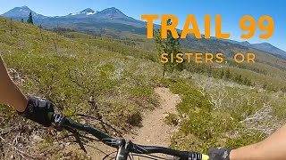
trail: Metolius Windigo - Trail 99
3:11 |
502 |
Oct 17, 2022 , Sisters

1:58:18 |
430 |
Jun 12, 2022 , Sisters
trail: Metolius Windigo - Trail 99
7:51 |
918 |
Nov 5, 2021 , Sisters
trail: Upper Glacier View
9:43 |
133 |
Aug 24, 2021 , Sisters

trail: Glacier View Loop Route
9:43 |
171 |
Aug 24, 2021 , Sisters
Recent Trail Reports
National Scenic Trails & Official Routes
-
Metolius Windigo Trail
- Mountain Bike
- E-Bike
- Horse
- Hike
- Trail Running
Activity Feed
| username | action | type | title | date |
|---|---|---|---|---|
| kbyron11 | wishlist | route | activity #97744739 | Jun 24, 2026 @ 8:23pm Jun 24, 2026 |
| dclarkmv | wishlist | route | activity #97693326 | Jun 24, 2026 @ 6:41am Jun 24, 2026 |
| wcortez | add | report | activity #97448268 and 1 more | Jun 20, 2026 @ 6:30pm Jun 20, 2026 |
| wcortez | add | report | activity #97448266 | Jun 20, 2026 @ 6:30pm Jun 20, 2026 |
| cbuehler | wishlist | route | activity #97054577 | Jun 15, 2026 @ 11:18am Jun 15, 2026 |
Recent Comments
| username | type | title | comment | date |
|---|---|---|---|---|
| trail | This trail will be realigned in 2026-27 as... | Apr 29, 2026 @ 3:25pm Apr 29, 2026 | ||
| trail | I once did a section of this that was very... | Nov 24, 2025 @ 12:05am Nov 24, 2025 | ||
| trail | Can confirm as of yesterday, the creek... | Jul 24, 2025 @ 10:11am Jul 24, 2025 | ||
| trail | Really enjoyed this one! Rode up the paved... | Jun 21, 2025 @ 1:47pm Jun 21, 2025 | ||
| report | Thanks for the report and nice job getting out... | Dec 31, 2024 @ 5:39pm Dec 31, 2024 |
Local Badges
-

10 Green Trails280 awarded -

Epic Ride Climb 2k140 awarded -

Climbing 10k Badge57 awarded -

Climbing 100k Badge0 awarded -

Epic Ride Descent 2k190 awarded -

Descent 10k Badge68 awarded
Bike & Skill Parks
| name | type | city | rating |
|---|---|---|---|
| Hoodoo Resort | bike park | Sisters | |
| Bike Park 242 | skill park | Sisters |
Local Mountain Biking Directory
-
Blazin Saddles
-
Eurosports
![Eurosports]()
-
Sisters Trails AllianceTrail Association
![Sisters Trails Alliance]()
Activity Type Stats
| activitytype | trails | distance | descent | descent distance | total vertical | rating | global rank | state rank | photos | reports | routes | ridelogs |
|---|---|---|---|---|---|---|---|---|---|---|---|---|
| Mountain Bike | 51 | 102 miles | 10,289 ft | 41 miles | 3,484 ft | #1,553 | #583 | 200 | 960 | 8 | 14,071 | |
| E-Bike | 37 | 48 miles | 2,060 ft | 14 miles | 2,405 ft | 2 | 677 | 223 | ||||
| Gravel Bike | 4 | 10 miles | 115 ft | 2 miles | 187 ft | #425 | #985 | 17 | 5 | 189 | ||
| Adaptive Bike | 3 | 8 miles | 115 ft | 2 miles | 157 ft | #375 | #1,674 | 2 | 2 | |||
| Winter Fat Bike | 1 | 3 miles | 249 ft | 1 mile | 187 ft | #282 | #1,043 | 19 | ||||
| Horse | 56 | 216 miles | 38,550 ft | 102 miles | 4,767 ft | #101 | #369 | 222 | 74 | |||
| Hike | 127 | 317 miles | 46,736 ft | 135 miles | 4,997 ft | #248 | #128 | 3 | 1,066 | 1 | 3,319 | |
| Trail Running | 126 | 314 miles | 46,709 ft | 135 miles | 4,997 ft | #386 | #152 | 2 | 1,062 | 1 | 1,049 | |
| Dirtbike/Moto | 1 | 2,530 ft | 30 ft | 2,405 ft | 30 ft | 85 | 30 | |||||
| ATV/ORV/OHV | 1 | 2,530 ft | 30 ft | 2,405 ft | 30 ft | 85 | 8 | |||||
| Snowmobile | 1 | 3 miles | 1,010 ft | 2 | ||||||||
| Snowshoe | 21 | 29 miles | 3,212 ft | 12 miles | 1,883 ft | #442 | #140 | 2 | 7 | 55 | ||
| Downhill Ski | 44 | 13 miles | 10,673 ft | 13 miles | 994 ft | #357 | #140 | 3 | 641 | |||
| Backcountry Ski | 33 | 48 miles | 3,960 ft | 18 miles | 2,526 ft | #308 | #52 | 10 | 713 | |||
| Nordic Ski | 44 | 54 miles | 4,383 ft | 20 miles | 2,526 ft | #336 | #87 | 1 | 7 | 372 |
Frequently Asked Questions About Sisters
▼
What are the best places to ride in Sisters?
Sisters has 12 areas to explore for mountain biking. The top rated areas are:
▼
What are the highest rated mountain biking trails in Sisters?
The highest rated mountain biking trails in Sisters are:
- Metolius Windigo - Trail 99 (4.5/5)
- Peterson Ridge Trail East - Upper (4.4/5)
- Peterson Ridge Trail West - Upper (4.3/5)
- South Pyramid Creek - Central (4.2/5)
- Peterson Ridge Trail East - Lower (4.2/5)
▼
What is the best time of the year to ride in Sisters?
Based on ride log data, the most popular months to ride in Sisters are:
- July (288 activities)
- June (218 activities)
- August (188 activities)
▼
Where can I park to ride in Sisters?
There are 30 parking locations listed in Sisters. The most popular parking spots are: View all parking and trailhead locations on the map to plan your visit.
Activities
Trails
Points of Interest
- Triangulation Peak Summit
- South Lodge
- Mountain View Snow Shelter Cabin
- South Snow Shelter Cabin
- Brandenburg Shelter Cabin
- Warming Hut Cabin
- Park Ridge Viewpoint
- Marion Viewpoint
- Marion Mountain Summit
- Mountain View Snow Shelter Cabin
- Bachelor Mountain (5,942 ft)
- Crescent Mountain (5,738 ft)
- Coffin Mountain (5,715 ft)
- By Brennanmorrow
 COTA MADRAS & contributors
 - Admins: STA, COTA, COTA
- #8370 - 22,420 views
- sisters activity log | embed map of Sisters mountain bike trails | sisters mountain biking points of interest
Downloading of trail gps tracks in kml & gpx formats is enabled for Sisters.
You must login to download files.